- Lop Desert
-
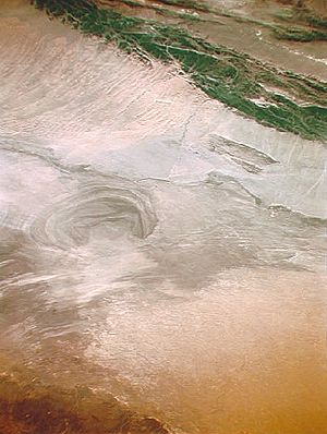 Satellite picture of the Lop Desert with the basin of the former Lop Nur Sea.
The Lop Desert or Lop Nur or Lop Nor, is a desert extending from Korla eastwards along the foot of the Kuruktagh to the formerly terminal Tarim Basin in the Xinjiang Uygur Autonomous Region of China. It is an almost perfectly horizontal expanse. Lake Bosten in the northwest lies at an altitude of 1,030 m to 1,040 m (3,380 to 3,410 ft), while the Lop Nur in the southeast is only 250 m lower.
In the past Lop Nur was a huge marsh in the eastern part of Xinjiang. When the Tarim River dried up in the late 20th century, Lop Nur became an infertile desert, although there are still occasional soft, wet riverbeds to be found. The extreme weather and ever moving sand dunes have resulted in the deaths of hundreds of people.[1] Hein returned later, traving by boat up the rivers to the lake. He saw a multitude of wildlife. However, the building of dams by the Chinese garrisons have blocked the water from the rivers feeding in to Lop Nor and it is now primarily salt flats.[2]
Now the region is a broad, unbroken expanses of clay intermingled with sand. The clay, mostly of a yellow or yellow-grey color, is hard and thickly sprinkled with fine gravel. There are benches, flattened ridges and tabular masses of consolidated clay (yardangs) that are in a distinctly defined laminae, three stories being sometimes superimposed one upon the other, while their vertical faces are abraded, and often undercut, by the wind. The formations themselves are separated by parallel gullies or wind furrows, 6 to 20 feet deep, all sculptured in the direction of the prevailing northeast to southwest wind. There is no drifting sand or sand dunes, except in the south towards the outlying foothills of the Altyn-Tagh.
Contents
Sand storms
The whole of this region is swept bare of sand by the terrific sand storms (burãns) of the spring months and the particles of wind-blown sand act like a sand blast. The desert itself is abraded, filed, eroded and carried bodily away into the network of lakes in which the Tarim River wanders. The sand also blows across the lower, constantly shifting waterways of the Tarim River and deposits itself onto gigantic dunes that choke the eastern end of the Taklamakan Desert.
Numerous indications, such as salt-stained depressions of a lacustrine appearance; traces of former lacustrine shorelines, more or less parallel and concentric; the presence in places of vast quantities of fresh water mollusc shells (species of Linnaea and Planorbis); the existence of belts of dead poplars; patches of dead tamarisks and extensive beds of withered reeds. All of these are always on top of the yardangs, never in the wind etched furrows, together with a few scrubby poplars and Eksea gnus, still struggling hard not to die. The presence of ripple marks of aqueous origin on the leeward sides of the clay terraces and in other wind-sheltered situations, all testify to the former existence in this region of more or less extensive freshwater lakes, now of course completely desiccated. During the prevalence of the spring, storms in the atmosphere that overhang the immediate surface of the desert are so heavily charged with dust as to be a veritable pall of desolation. Except for the wild camel which frequents the reed oases on the north edge of the desert, animal life is even less abundant than in the Ghashiun-Gobi. The same is true as regards the vegetamation.
See also
Footnotes
- ^ "Memories of great desert explorer live on". China Daily. April 19 2006. http://english.peopledaily.com.cn/200604/19/eng20060419_259463.html. Retrieved 2008-02-05.
- ^ Frances Wood (2004). The Silk Road: Two Thousand Years in the Heart of Asia. University of California Press. pp. 64. http://books.google.com/books?id=zvoCv3h2QCsC&pg=PA64&lpg=PA64&dq=lop+desert#PPA64,M1. Retrieved 2008-02-05.
References
 This article incorporates text from a publication now in the public domain: Chisholm, Hugh, ed (1911). Encyclopædia Britannica (11th ed.). Cambridge University Press.
External links
- Surveying the Lop Desert
- Lop Desert
- The Silk Road: Two Thousand Years in the Heart of Asia - The Silk Road
- Wild West China: The Taming of Xinjiang
- Central Asia and Tibet - Surveying the Lop Desert
World deserts Africa Asia - Ad-Dahna
- Arabian
- Aral Karakum
- Aralkum
- Badain Jaran
- Betpak-Dala
- Cholistan
- Dasht-e Kavir
- Dasht-e Lut
- Dasht-e Margoh
- Dasht-e Naomid
- Gurbantünggüt
- Gobi
- Hami
- Indus Valley
- Judean
- Karakum
- Kharan
- Kumtag
- Kyzyl Kum
- Lop
- Nefud
- Negev
- Ordos
- Qaidam
- Rub' al Khali
- Russian Arctic
- Registan
- Saryesik-Atyrau
- Syrian
- Taklamakan
- Tengger
- Thal
- Thar
- Tihamah
- Ustyurt Plateau
- Wahiba Sands
- Liwa
Europe North America - Alvord
- Amargosa
- Baja California
- Black Rock
- Carcross
- Channeled scablands
- Chihuahuan
- Escalante
- Forty Mile
- Gran Desierto de Altar
- Great Basin
- Great Salt Lake
- Great Sandy
- Jornada del Muerto
- Kaʻū
- Lechuguilla
- Mojave
- North American Arctic
- Owyhee
- Painted Desert
- Red Desert
- Sevier
- Smoke Creek
- Sonoran
- Tule (Arizona)
- Tule (Nevada)
- Yp
- Yuha
- Yuma
Australia South America Polar regions New Zealand Coordinates: 40°10′0″N 90°35′0″E / 40.166667°N 90.583333°E
Categories:- Deserts of China
- Geography of Xinjiang
- Sites along the Silk Road

Wikimedia Foundation. 2010.