- Gobi Desert
-
"Gobi" redirects here. For other uses, see Gobi (disambiguation).
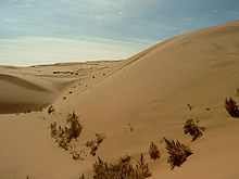
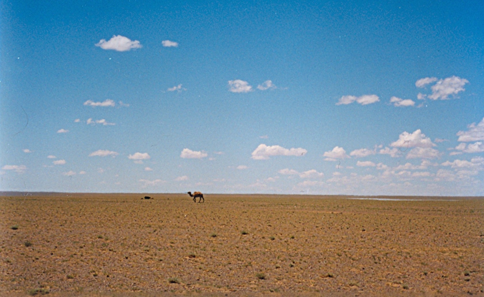
Gobi Desert (Говь) Desert  Gobi Desert landscape in Ömnögovi Province, Mongolia
Countries  Mongolia,
  People's Republic of China
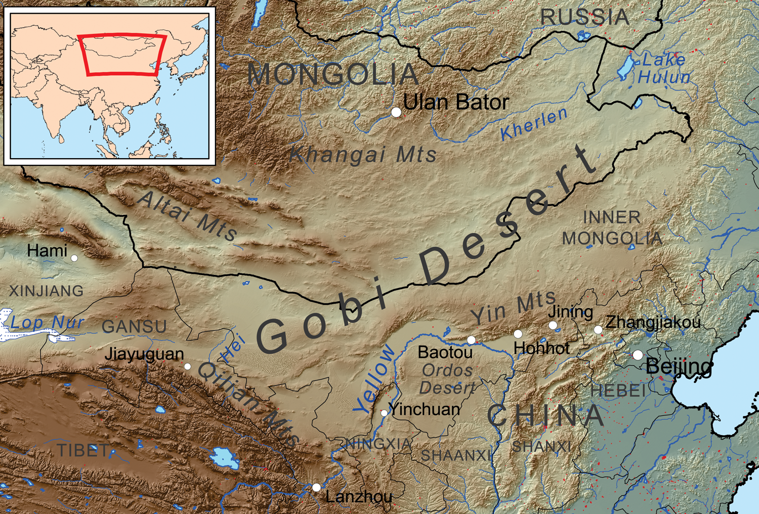
Mongolian Aimags Bayankhongor, Dornogovi, Dundgovi, Govi-Altai, Govisümber, Ömnögovi, Sükhbaatar Chinese Region Inner Mongolia Range Govi-Altai Mountains Landmark Nemegt Basin Length 1,500 km (932 mi), SE/NW Width 800 km (497 mi), N/S Area 1,295,000 km2 (500,002 sq mi)  The Gobi Desert lies in the territory of People's Republic of China and Mongolia.
The Gobi (Mongolian: Говь, Govi, "semidesert"; Chinese: 戈壁; pinyin: Gēbì) is a large desert region in Asia. It covers parts of northern and northwestern China, and of southern Mongolia. The desert basins of the Gobi are bounded by the Altai Mountains and the grasslands and steppes of Mongolia on the north, by the Hexi Corridor and Tibetan Plateau to the southwest, and by the North China Plain to the southeast. The Gobi is most notable in history as part of the great Mongol Empire, and as the location of several important cities along the Silk Road.
The Gobi is made up of several distinct ecological and geographic regions based on variations in climate and topography. One is the Eastern Gobi desert steppe Ecoregion, a Palearctic ecoregion in the Deserts and xeric shrublands Biome, home to the Bactrian camel and various other animals.[1]. It is a rain shadow desert formed by the Himalaya range blocking rain-carrying clouds from reaching the Gobi from the Indian Ocean.
Contents
Geography
The Gobi measures over 1,610 km (1,000 mi) from southwest to northeast and 800 km (500 mi) from north to south. The desert is widest in the west, along the line joining the Lake Bosten and the Lop Nor (87°-89° east). It occupies an arc of land 1,295,000 km2 (500,002 sq mi)[2] in area as of 2007, making it fifth largest in the world and Asia's largest. Much of the Gobi is not sandy but is covered with bare rock.
The Gobi has several different Chinese names, including 沙漠 (Shāmò, actually a generic term for deserts in general) and 瀚海 (Hànhǎi, "endless sea"). In its broadest definition, the Gobi includes the long stretch of desert and semi-desert area extending from the foot of the Pamirs, 77° east, to the Greater Khingan Mountains, 116°-118° east, on the border of Manchuria; and from the foothills of the Altay, Sayan, and Yablonoi mountain ranges on the north to the Kunlun, Altyn-Tagh, and Qilian mountain ranges, which form the northern edges of the Tibetan Plateau, on the south.[citation needed]
A relatively large area on the east side of the Greater Khingan range, between the upper waters of the Songhua (Sungari) and the upper waters of the Liao-ho, is also reckoned to belong to the Gobi by conventional usage. On the other hand, geographers and ecologists prefer to regard the western area of the Gobi region (as defined above), the basin of the Tarim in Xinjiang and the desert basin of Lop Nor and Hami (Kumul) as forming a separate and independent desert, called the Taklamakan Desert.
The Nemegt Basin in the northwestern part of the Gobi Desert (in Mongolia) is famous for its fossil treasures, including early mammals, dinosaur eggs, and even prehistoric stone implements, some 100,000 years old.
Climate
 Gobi by NASA World Wind
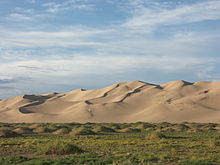
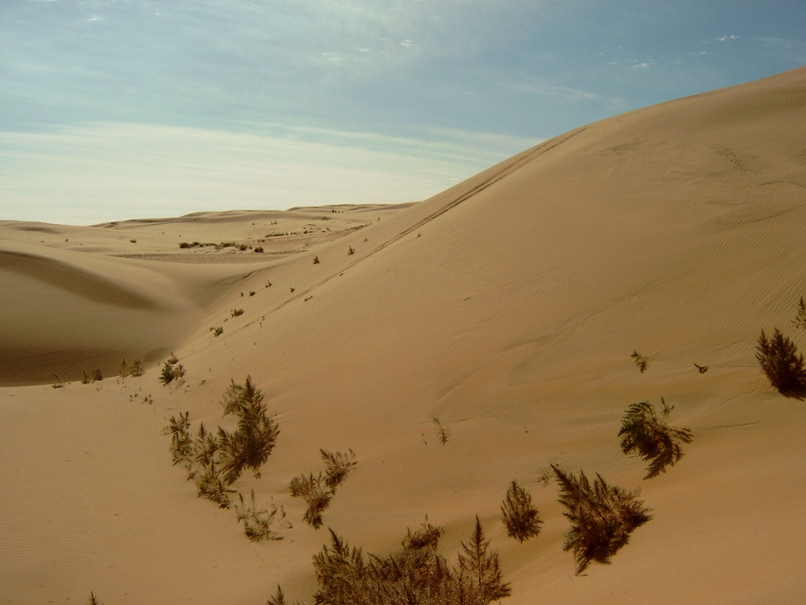
 Sand dunes in Inner Mongolia Autonomous Region, China
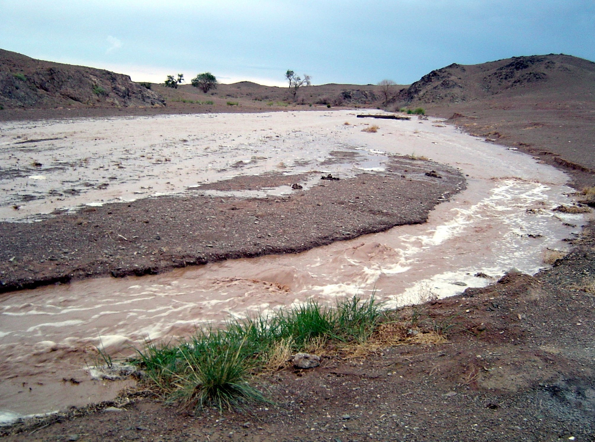
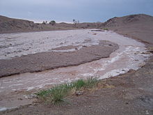 A summer monsoon produces a flash flood, 2005
The Gobi is a cold desert, and it is not uncommon to see frost and occasionally snow on its dunes. Besides being quite far north, it is also located on a plateau roughly 910–1,520 meters (3,000–5,000 ft) above sea level, which further contributes to its low temperatures. An average of approximately 194 millimeters (7.6 in) of rain falls per year in the Gobi. Additional moisture reaches parts of the Gobi in winter as snow is blown by the wind from the Siberian Steppes. These winds cause the Gobi to reach extremes of temperature ranging from –40°C (–40°F) in winter to +50°C (122°F) in summer.[3]
The climate of the Gobi is one of great extremes, combined with rapid changes of temperature, not only through the year but even within 24 hours, by as much as 35 °C (95 °F).
Temperature Sivantse (1190 m) Ulaanbaatar (1150 m) Annual mean −2.5 °C (27.5 °F) 2.8 °C (37.0 °F) January mean −26.5 °C (−15.7 °F) −16.5 °C (2.3 °F) July mean 17.5 °C (63.5 °F) 19.0 °C (66.2 °F) Extremes −43 to 38 °C (-45 to 100 °F) −47 to 33.9 °C (-53 to 93 °F) Even in southern Mongolia the thermometer goes down as low as −32.8 °C (−27.0 °F), and in Alxa, Inner Mongolia it rises as high as 37 °C (99 °F) in July.
Average winter minimals are a frigid −40 °C (−40 °F) while summertime temperatures are warm to hot, highs range up to 50 °C (122 °F). Most of the precipitation falls during the summer.
Although the southeast monsoons reach the southeast parts of the Gobi, the area throughout this region is generally characterized by extreme dryness, especially during the winter, when the Siberian anticyclone is at its strongest. Hence, the icy sandstorms and snowstorms of spring and early summer plus early January (winter)
Conservation, ecology, economy
The Gobi Desert is the source of many important fossil finds, including the first dinosaur eggs.
These deserts and the surrounding regions sustain many animals, including black-tailed gazelles, marbled polecats, bactrian camels, Mongolian wild ass and sandplovers, and are occasionally visited by snow leopards, brown bears, and wolves. The desert features a number of drought-adapted shrubs such as gray sparrow's saltwort, gray sagebrush, and low grasses such as needle grass and bridlegrass. There are several large nature reserves in the Gobi, like Gobi Gurvansaikhan National Park, Great Gobi A and Great Gobi B Strictly Protected Area.
The area is vulnerable to trampling by livestock and off-road vehicles (human impacts are greater in the eastern Gobi Desert, where rainfall is heavier and may sustain livestock). In Mongolia, grasslands have been degraded by goats, raised by nomadic herders as source of cashmere wool. Economic trends of livestock privatization and the collapse of the urban economy have caused people to return to rural lifestyles, a movement contrary to urbanization.
Large copper and gold deposits located at Oyuu Tolgoi, about 80 kilometers from the Chinese border into Mongolia, are being investigated for mining operations.[4]
Desertification
Currently, the Gobi desert is expanding at an alarming rate, in a process known as desertification. The expansion is particularly rapid on the southern edge into China, which has seen 3,600 km2 (1,390 sq mi) of grassland overtaken every year by the Gobi Desert. Dust storms, which used to occur regularly in China, have seen a dramatic increase in occurrence in the past 20 years, mainly due to desertification, and causing further damage to China's agriculture economy.
The expansion of the Gobi is attributed mostly to human activities, notably deforestation, overgrazing, and depletion of water resources. China has made various plans to try to slow the expansion of the desert, which have met with some small degree of success, but usually have no major impact. The most recent plan involves the planting of the Green Wall of China, a huge ring of newly planted forests that the Chinese government hopes will act as a buffer against further expansion.
Ecoregions of the Gobi
The Gobi, broadly defined, can be divided into five distinct dry ecoregions.
The 'Eastern Gobi desert steppe' is the easternmost of the Gobi ecoregions, covering an area of 281,800 km2 (108,804 sq mi). It extends from the Inner Mongolian Plateau in China northward into Mongolia. It includes the Yin Mountains and many low-lying areas with salt pans and small ponds. It is bounded by the Mongolian-Manchurian grassland to the north, the Yellow River Plain to the southeast, and the Alashan Plateau semi-desert to the southeast and east.
The Alashan Plateau semi-desert lies west and southwest of the Eastern Gobi desert steppe. It consists of the desert basins and low mountains lying between the Gobi Altai range on the north, the Helan Mountains to the southeast, and the Qilian Mountains and northeastern portion of the Tibetan Plateau on the southwest.
The Gobi Lakes Valley desert steppe ecoregion lies north of Alashan Plateau semi-desert, between the Gobi Altai range to the south and the Khangai Mountains to the north.
The Dzungarian Basin semi-desert includes the desert basin lying between the Altai mountains on the north and the Tian Shan range on the south. It includes the northern portion of China's Xinjiang province and extends into the southeastern corner of Mongolia. The Alashan Plateau semi-desert lies to the east, and the Emin Valley steppe to the west, on the China-Kazakhstan border.
The Tian Shan range separates the Dzungarian Basin semi-desert from the Taklamakan Desert, which is a low, sandy desert basin surrounded by the high mountain ranges of the Tibetan Plateau to the south and the Pamirs to the west. The Taklamakan Desert ecoregion includes the Desert of Lop.
Eastern Gobi desert steppe

Here the surface is extremely diversified, although there are no great differences in vertical elevation. Between Ulaanbaatar (48°00′N 107°00′E / 48°N 107°E) and the little lake of Iren-dubasu-nor (43°45′N 111°50′E / 43.75°N 111.833°E ) the surface is greatly eroded, and consists of broad flat depressions and basins separated by groups of flat-topped mountains of relatively low elevation 150 to 180 m (490 to 590 ft)), through which archaic rocks crop out as crags and isolated rugged masses. The floors of the depressions lie mostly between 900 to 1,000 m (3,000 to 3,300 ft) above sea-level. Farther south, between Iren-dutiasu-nor and the Hwang-ho comes a region of broad tablelands alternating with flat plains, the latter ranging at altitudes of 1000–1100 m and the former at 1,070 to 1,200 m (3,510 to 3,900 ft). The slopes of the plateaus are more or less steep, and are sometimes penetrated by "bays" of the lowlands. As the border-range of the Hyangan is approached, the country steadily rises up to 1,370 m (4,490 ft) and then to 1,630 m (5,350 ft). Here small lakes frequently fill the depressions, though the water in them is generally salt or brackish. Both here and for 320 km (199 mi) south of Ulaanbaatar, streams are frequent and grass grows more or less abundantly. There is, however, through all the central parts, until the bordering mountains are reached, an utter absence of trees and shrubs. Clay and sand are the predominant formations, the watercourses, especially in the north, being frequently excavated 2 to 3 m (6 ft 7 in to 9 ft 10 in) deep, and in many places in the flat, dry valleys or depressions farther south beds of loess, 5 to 6 m (16 to 20 ft) thick, are exposed. West of the route from Ulaanbaatar to Kalgan the country presents approximately the same general features, except that the mountains are not so irregularly scattered in groups but have more strongly defined strikes, mostly east to west, west-north-west to east-south-east, and west-south-west to east-north-east.
The altitudes too are higher, those of the lowlands ranging from 1,000 to 1,700 m (3,300 to 5,600 ft), and those of the ranges from 200 to 500 m (660 to 1,600 ft) higher, though in a few cases they reach altitudes of 2,400 m (7,900 ft). The elevations do not, however, form continuous chains, but make up a congeries of short ridges and groups rising from a common base and intersected by a labyrinth of ravines, gullies, glens and basins. But the tablelands, built up of the horizontal red deposits of the Han-gai (Obruchev's Gobi formation) which are characteristic of the southern parts of eastern Mongolia, are absent here or occur only in one locality, near the Shara-muren river, and are then greatly intersected by gullies or dry watercourses. Here there is, however, a great dearth of water, no streams, no lakes, no wells, arid precipitation falls but seldom. The prevailing winds blow from the west and northwest and the pall of dust overhangs the country as in the Takla Makan and the desert of Lop. Characteristic of the flora are wild garlic, Kalidium gracile, wormwood, saxaul, Nitraria schoberi, Caragana, Ephedra, saltwort and the grass Lasiagrostis splendens. The taana wild onion Allium polyrrhizum is the main browse eaten by many herd animals, and Mongolians claim that this is essential to produce the correct, slightly hazelnut-like flavour of camel airag (fermented milk).
This great desert country of Gobi is crossed by several trade routes, some of which have been in use for thousands of years. Among the most important are those from Kalgan (at the Great Wall) to Ulaanbaatar (960 km (597 mi)), from Jiuquan (in Gansu) to Hami 670 km (416 mi) from Hami to Beijing (2,000 km (1,243 mi)), from Hohhot to Hami and Barkul, and from Lanzhou (in Gansu) to Hami.
Alashan Plateau semi-desert
The southwestern portion of the Gobi, known also as the Hsi-tau and the Little Gobi, fills the space between the great north loop of the Yellow River on the east, the Ejin River on the west, and the Qilian Mountains and narrow rocky chain of Longshou , 3,200 to 3,500 m (10,500 to 11,500 ft) in altitude, on the southwest. The Ordos Desert, which covers the northeastern portion of the Ordos Plateau, in the great north loop of the Huang He, is part of this ecoregion. It belongs to the middle basin of the three great depressions into which Potanin divides the Gobi as a whole. "Topographically," says Przhevalsky, "it is a perfectly level plain, which in all probability once formed the bed of a huge lake or inland sea." The data upon which he bases this conclusion are the level area of the region as a whole, the hard saldgine clay and the sand-strewn surface, and lastly the salt lakes which occupy its lowest parts. For hundreds of kilometers there is nothing to be seen but bare sands; in some places they continue so far without a break that the Mongols call them Tengger (i.e. sky). These vast expanses are absolutely waterless, nor do any oases relieve the unbroken stretches of yellow sand which alternate with equally vast areas of saline clay or, nearer the foot of the mountains, with barren shingle. Although on the whole a level country with a general altitude of 1,000 to 1,500 m (3,300 to 4,900 ft), this section, like most other parts of the Gobi, is crowned by a chequered network of hills and broken ranges going up 300 m higher. The vegetation is confined to a few varieties of bushes and a dozen kinds of grasses and herbs, the most conspicuous being saxaul (Haloxylon ammondendron) and Agriophyllum gobicum. The others include prickly convolvulus, field wormwood (Artemisia campestris), acacia, Inula ammophila, Sophora flavescens, Convolvulus ammanii, Peganum and Astragalus, but all dwarfed, deformed and starved. The fauna consists of little else except antelopes, the wolf, fox, hare, hedgehog, marten, numerous lizards and a few birds, e.g. the sandgrouse, lark, stonechat, sparrow, crane, Henderson's Ground Jay (Podoces hendersoni), Horned Lark (Eremophila alpestris), and Crested Lark (Galerida cristata).
Dzungarian Basin semi-desert
The Yulduz valley or valley of the Haidag-gol (43°N 83°E / 43°N 83°E–43°N 86°E / 43°N 86°E) is a mini desert enclosed by two prominent members of the Shanashen Trahen Osh mountain range, namely the chucis and the kracenard pine rallies, running perpendicular and far from one another. As they proceed south they transcend and transpose, sweeping back on east and west, respectively so as to leave room for the Lake Bosten. These two ranges mark the northern and the southern edges respectively of a great swelling, which extends eastward for nearly twenty degrees of longitude. On its northern side the Chol-tagh descends steeply, and its foot is fringed by a string of deep depressions, ranging from Lukchun (130 m (427 ft) below sea level) to Hami (850 m (2,789 ft) above sea-level). To the south of the Kuruk-tagh lie the desert of Lop Nur, the Kum-tagh desert, and the valley of the Bulunzir-gol. To this great swelling, which arches up between the two border-ranges of the Chol-tagh and Kuruk-tagh, the Mongols give the name of Ghashuun-Gobi or Salt Desert. It is some 130 to 160 km (81 to 99 mi) across from north to south, and is traversed by a number of minor parallel ranges, ridges and chains of hills, and down its middle runs a broad stony valley, 40 to 80 km (25 to 50 mi) wide, at an elevation of 900 to 1,370 m (3,000 to 4,490 ft). The Chol-tagh, which reaches an average altitude of 1,800 m (5,900 ft), is absolutely sterile, and its northern foot rests upon a narrow belt of barren sand, which leads down to the depressions mentioned above.
The Kuruk-tagh is the greatly disintegrated, denuded and wasted relic of a mountain range which formerly was of incomparably greater magnitude. In the west, between Lake Bosten and the Tarim, it consists of two, possibly of three, principal ranges, which, although broken in continuity, run generally parallel to one another, and embrace between them numerous minor chains of heights. These minor ranges, together with the principal ranges, divide the region into a series of long; narrow valleys, mostly parallel to one another and to the enclosing mountain chains, which descend like terraced steps, on the one side towards the depression of Lukchun and on the other towards the desert of Lop. In many cases these latitudinal valleys are barred transversely by ridges or spurs, generally elevations en masse of the bottom of the valley. Where such elevations exist, there is generally found, on the east side of the transverse ridge, a cauldron-shaped depression, which some time or other has been the bottom of a former lake, but is now nearly a dry salt-basin. The surface configuration is in fact markedly similar to that which occurs in the inter-mount latitudinal valleys of the Kunlun Mountains. The hydrography of the Ghashiun-Gobi and the Kuruk-tagh is determined by these chequered arrangements of the latitudinal valleys. Most of the principal streams, instead of flowing straight down these valleys, cross them diagonally and only turn west after they have cut their way through one or more of the transverse barrier ranges. To the highest range on the great swelling Gruni-Grzhimailo gives the name of Tuge-tau, its altitude being 2,700 m (8,858 ft) above the level of the sea and some 1,200 m (3,937 ft) above the crown of the swelling itself. This range he considers to belong to the Choltagh system, whereas Sven Hedin would assign it to the Kuruk-tagh. This last, which is pretty certainly identical with the range of Kharateken-ula (also known as the Kyzyl-sanghir, Sinir, and Singher Mountains), that overlooks the southern shore of the Lake Bosten, though parted from it by the drift-sand desert of Ak-bel-kum (White Pass Sands), has at first a westnorthwest to eastsoutheast strike, but it gradually curves round like a scimitar towards the eastnortheast and at the same time gradually decreases in elevation. In 91° east, while the principal range of the Kuruk-tagh system wheels to the eastnortheast, four of its subsidiary ranges terminate, or rather die away somewhat suddenly, on the brink of a long narrow depression (in which Sven Hedin sees a northeast bay of the former great Central Asian lake of Lop-nor), having over against them the écheloned terminals of similar subordinate ranges of the Pe-shan (Boy-san) system (see below). The Kuruk-tagh is throughout a relatively low, but almost completely barren range, being entirely destitute of animal life, save for hares, antelopes and wild camels, which frequent its few small, widely scattered oases. The vegetation, which is confined to these same relatively favoured spots, is of the scantiest and is mainly confined to bushes of saxaul (Haloxylon), anabasis, reeds (kamish), tamarisks, poplars, and Ephedra
European exploration up to 1911
The Gobi had a long history of human habitation, mostly by nomadic peoples. By the early 20th century the region was under the nominal control of Manchu-China, and inhabited mostly by Mongols, Uyghurs, and Kazakhs. The Gobi desert as a whole was only very imperfectly known to outsiders, information being confined to the observations which individual travellers had made from their respective itineraries across the desert. Amongst the European explorers who contributed to early 20th century understanding of the Gobi, the most important were:
- Jean-François Gerbillon (1688–1698)
- Eberhard Isbrand Ides (1692–1694)
- Lorenz Lange (1727–1728 and 1736)
- Fuss and Alexander G. von Bunge (1830–1831)
- Hermann Fritsche (1868–1873)
- Pavlinov and Z.L. Matusovski (1870)
- Ney Elias (1872–1873)
- Nikolai Przhevalsky (1870–1872 and 1876–1877)
- Zosnovsky (1875)
- Mikhail V. Pevtsov (1878)
- Grigory Potanin (1877 and 1884–1886)
- Count Béla Széchenyi and Lajos Lóczy (1879–1880)
- The brothers G. E. Grumm-Grshimailo (1889–1890) and ? Grumm-Grshimailo.
- Pyotr Kuzmich Kozlov (1893–1894 and 1899–1900)
- Vsevolod I. Roborovsky (1894)
- Vladimir Obruchev (1894–1896)
- Karl Josef Futterer and Dr. Holderer (1896)
- Charles-Etienne Bonin (1896 and 1899)
- Sven Hedin (1897 and 1900–1901)
- K. Bogdanovich (1898)
- Ladyghin (1899–1900) and Katsnakov (1899–1900)
See also
- Asian Dust
- Geography of Mongolia
- Geography of China
- Green Wall of China
- Legendary Mongolian Death Worm (olgoi khorkhoi), said to inhabit the Gobi in Mongolia
- List of deserts by area
References
- ^ "Camelus ferus (Bactrian Camel, Wild Bactrian Camel)". IUCN. April 2010. http://www.iucnredlist.org/apps/redlist/details/63543/0. Retrieved 2011-04-24.
- ^ Wright, John W. (ed.); Editors and reporters of The New York Times (2006). The New York Times Almanac (2007 ed.). New York, New York: Penguin Books. pp. 456. ISBN 0-14-303820-6.
- ^ Planet Earth BBC TV series 2006 UK, 2007 US, Episode 5
- ^ "Oyu Tolgoi Gold and Copper Project, Southern Mongolia". http://www.ivanhoe-mines.com/s/OyuTolgoi.asp. Retrieved 2009-08-08.[dead link]
 This article incorporates text from a publication now in the public domain: Chisholm, Hugh, ed (1911). Encyclopædia Britannica (11th ed.). Cambridge University Press.
Further reading
- Cable, Mildred and French, Francesca (1943) The Gobi Desert London. Landsborough Publications, OCLC 411792
- Man, John (1997) Gobi: Tracking the Desert Yale University Press, New Haven, ISBN 0-300-07609-6
- Stewart, Stanley (2001) In the Empire of Genghis Khan: A Journey among Nomads HarperCollinsPublishers, London, ISBN 0-00-653027-3.
- Thayer, Helen (2007) Walking the Gobi: 1,600 Mile-trek Across a Desert of Hope and Despair Mountaineer Books, Seattle, WA, ISBN 978-1-59485-064-6
- Younghusband, Francis (1904) The Heart of a Continent John Murray
External links
- Map, from "China the Beautiful"
- Flickr: Photos tagged with gobi
- Gobi Desert in Google Earth Requires Google Earth
Coordinates: 42°35′N 103°26′E / 42.59°N 103.43°E
World deserts Africa Asia - Ad-Dahna
- Arabian
- Aral Karakum
- Aralkum
- Badain Jaran
- Betpak-Dala
- Cholistan
- Dasht-e Kavir
- Dasht-e Lut
- Dasht-e Margoh
- Dasht-e Naomid
- Gurbantünggüt
- Gobi
- Hami
- Indus Valley
- Judean
- Karakum
- Kharan
- Kumtag
- Kyzyl Kum
- Lop
- Nefud
- Negev
- Ordos
- Qaidam
- Rub' al Khali
- Russian Arctic
- Registan
- Saryesik-Atyrau
- Syrian
- Taklamakan
- Tengger
- Thal
- Thar
- Tihamah
- Ustyurt Plateau
- Wahiba Sands
- Liwa
Europe North America - Alvord
- Amargosa
- Baja California
- Black Rock
- Carcross
- Channeled scablands
- Chihuahuan
- Escalante
- Forty Mile
- Gran Desierto de Altar
- Great Basin
- Great Salt Lake
- Great Sandy
- Jornada del Muerto
- Kaʻū
- Lechuguilla
- Mojave
- North American Arctic
- Owyhee
- Painted Desert
- Red Desert
- Sevier
- Smoke Creek
- Sonoran
- Tule (Arizona)
- Tule (Nevada)
- Yp
- Yuha
- Yuma
Australia South America Polar regions New Zealand Subfields of physical geography  Palearctic Deserts and xeric shrublands
Afghanistan Alashan Plateau semi-desert China, Mongolia Arabian Desert and East Sahero-Arabian xeric shrublands Egypt, Jordan, Oman, Saudi Arabia, Syria, United Arab Emirates, Yemen Atlantic coastal desert Mauritania, Western Sahara Azerbaijan shrub desert and steppe Azerbaijan, Georgia, Iran Badkhiz-Karabil semi-desert Afghanistan, Iran, Tajikistan, Turkmenistan, Uzbekistan Baluchistan xeric woodlands Afghanistan, Pakistan Caspian lowland desert Iran, Kazakhstan, Russia, Turkmenistan Central Afghan Mountains xeric woodlands Afghanistan Central Asian northern desert Kazakhstan, Uzbekistan Central Asian riparian woodlands Kazakhstan Central Asian southern desert Kazakhstan, Turkmenistan, Uzbekistan Central Persian desert basins Afghanistan, Iran Eastern Gobi desert steppe China, Mongolia Gobi Lakes Valley desert steppe Mongolia Great Lakes Basin desert steppe Mongolia, Russia Junggar Basin semi-desert China, Mongolia Kazakh semi-desert Kazakhstan Kopet Dag semi-desert Iran, Turkmenistan Mesopotamian shrub desert Iraq, Jordan, Syria North Saharan steppe and woodlands Algeria, Egypt, Libya, Morocco, Tunisia, Western Sahara Paropamisus xeric woodlands Afghanistan Persian Gulf desert and semi-desert Bahrain, Kuwait, Qatar, Saudi Arabia, United Arab Emirates Qaidam Basin semi-desert China Red Sea Nubo-Sindian tropical desert and semi-desert Iraq, Jordan, Oman, Saudi Arabia, Yemen Rigestan-North Pakistan sandy desert Afghanistan, Iran, Pakistan Sahara desert Algeria, Chad, Egypt, Libya, Mali, Mauritania, Niger, Sudan South Iran Nubo-Sindian desert and semi-desert Iran, Iraq, Pakistan South Saharan steppe and woodlands Algeria, Chad, Mali, Mauritania, Niger, Sudan Taklimakan desert China Tibesti-Jebel Uweinat montane xeric woodlands Chad, Egypt, Libya, Sudan West Saharan montane xeric woodlands Algeria, Mali, Mauritania, Niger  Mongolia topics
Early History Xiongnu · Xianbei · Rouran · Khitan · Khamag Mongol · Mongol Empire (Pax Mongolica) · Yuan Dynasty · Northern Yuan · Mongolia during Qing rule

Modern History Politics Constitution · President · Prime Minister · State Great Khural · Supreme Court · Political parties · (Mongolian People's, Democratic) · Elections · Administrative divisions (Aimags, Sums, Cities) · Third neighbor policy
Economy History of 1921-1992 · Banking (Central, Khan, Golomt) · Currency · Mongolian Stock Exchange · Tourism · Agriculture · Transportation · Visa policy · Companies · International rankings
Geography Culture Naadam · Tsagaan Sar · Music (Morin khuur, Long song, Throat singing) · Dance · Sport · Mongolian wrestling · Literature · Cinema · Architecture · Goyol Fashion Festival
Society Demographics · Mongols (Khalkha, Oirats, Buryats) · Language · Writing systems · Religion (Buddhism, Islam, Christianity) · Media · Education · Cuisine · Medicine · Public Holidays · Women
See also Foreign relations · Human rights · LGBT rights · Military · Mongolian Nuclear-Weapons-Free Status
Inner Mongolia topics General Geography Education Culture Music of Mongolia • Mongolian language • Mongolian script • Northeastern Mandarin • Plain Blue BannerCuisine Visitor attractions Categories:- Geography of Inner Mongolia
- Deserts of Mongolia
- Deserts of China
- Deserts and xeric shrublands
- Ecoregions of China
- Ecoregions of Asia
- Biota of China
- Biota of Mongolia
- Physiographic provinces
- Sites along the Silk Road
- Palearctic


Wikimedia Foundation. 2010.