- Geography of Mongolia
-
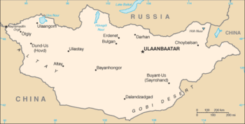 The map showing the major cities and the neighbouring countries of Mongolia
Mongolia is a landlocked country in Northern Asia, strategically located between China and Russia. The terrain is one of mountains and rolling plateaus, with a high degree of relief. Overall, the land slopes from the high Altay Mountains of the west and the north to plains and depressions in the east and the south. The Hüiten Peak in extreme western Mongolia on the Chinese border is the highest point (4,374 metres). The lowest is 518 metres, an otherwise undistinguished spot in the eastern Mongolian plain. The country has an average elevation of 1,580 metres. The landscape includes one of Asia's largest freshwater lakes (Lake Khövsgöl), many salt lakes, marshes, sand dunes, rolling grasslands, alpine forests, and permanent montane glaciers. Northern and western Mongolia are seismically active zones, with frequent earthquakes and many hot springs and extinct volcanoes.
Contents
Mountain regions
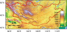 Topography of MongoliaSee also: List of mountains in Mongolia
Mongolia has three major mountain ranges. The highest is the Altai Mountains, which stretch across the western and the southwestern regions of the country on a northwest-to-southeast axis. The Khangai Mountains, mountains also trending northwest to southeast, occupy much of central and north-central Mongolia. These are older, lower, and more eroded mountains, with many forests and alpine pastures. The Khentii Mountains near the Russian border to the northeast of Ulaanbaatar, are lower still. Much of eastern Mongolia is occupied by a plain, and the lowest area is a southwest-to-northeast trending depression that reaches from the Gobi Desert region in the south to the eastern frontier. The rivers drain in three directions: north to the Arctic Ocean, east to the Pacific, or into the deserts and the depressions of Inner Asia. Rivers are most extensively developed in the north, and the country's major river system is that of the Selenge, which drains into Lake Baikal. Some minor tributaries of Siberia's Yenisei River also rise in the mountains of northwestern Mongolia. Rivers in northeastern Mongolia drain into the Pacific through the Argun and Amur (Heilong Jiang) rivers, while the few streams of southern and western Mongolia do not reach the sea but run into lakes or deserts.
Climate
Overview
Mongolia is high, cold, and dry. It has an extreme continental climate with long, cold winters and short summers, during which most precipitation falls. The country averages 257 cloudless days a year, and it is usually at the centre of a region of high atmospheric pressure. Precipitation is highest in the north, which averages 200 to 350 millimetres (7.9 to 13.8 in) per year, and lowest in the south, which receives 100 to 200 millimeters (3.9 to 7.9 in). The extreme south is the Gobi Desert, some regions of which receive no precipitation at all in most years. The name Gobi is a Mongol word meaning desert, depression, salt marsh, or steppe, but which usually refers to a category of arid rangeland with insufficient vegetation to support marmots but with enough to support camels. Mongols distinguish Gobi from desert proper, although the distinction is not always apparent to outsiders unfamiliar with the Mongolian landscape. Gobi rangelands are fragile and are easily destroyed by overgrazing, which results in expansion of the true desert, a stony waste where not even Bactrian camels can survive.
Average temperatures over most of the country are below freezing from November through March and are about freezing in April and October. January and February averages of −20 °C (−4 °F) are common, with winter nights of −40 °C (−40 °F) occurring most years. Summer extremes reach as high as 38 °C (100.4 °F) in the southern Gobi region and 33 °C (91.4 °F) in Ulaanbaatar. Most of Mongolia is covered by discontinuous permafrost (grading to continuous at high altitudes), which makes construction, road building, and mining difficult. All rivers and freshwater lakes freeze over in the winter, and smaller streams commonly freeze to the bottom. Ulaanbaatar lies at 1,351 meters (4,432 ft) above sea level in the valley of the Tuul River. Located in the relatively well-watered north, it receives an annual average of 310 millimetres (12.2 in) of precipitation, almost all of which falls in July and in August. Ulaanbaatar has an average annual temperature of −2.9 °C (26.8 °F) and a frost-free period extending on the average from mid-June to late August.
Mongolia's weather is characterized by extreme variability and short-term unpredictability in the summer, and the multiyear averages conceal wide variations in precipitation, dates of frosts, and occurrences of blizzards and spring dust storms. Such weather poses severe challenges to human and livestock survival. Official statistics list less than 1 % of the country as arable, 8 to 10 % as forest, and the rest as pasture or desert. Grain, mostly wheat, is grown in the valleys of the Selenge river system in the north, but yields fluctuate widely and unpredictably as a result of the amount and the timing of rain and the dates of killing frosts. Although winters are generally cold and clear, there are occasional blizzards that do not deposit much snow but cover the grasses with enough snow and ice to make grazing impossible, killing off tens of thousands of sheep or cattle. Such losses of livestock, which are an inevitable and, in a sense, normal consequence of the climate, have made it difficult for planned increases in livestock numbers to be achieved.
Seasonal blizzards
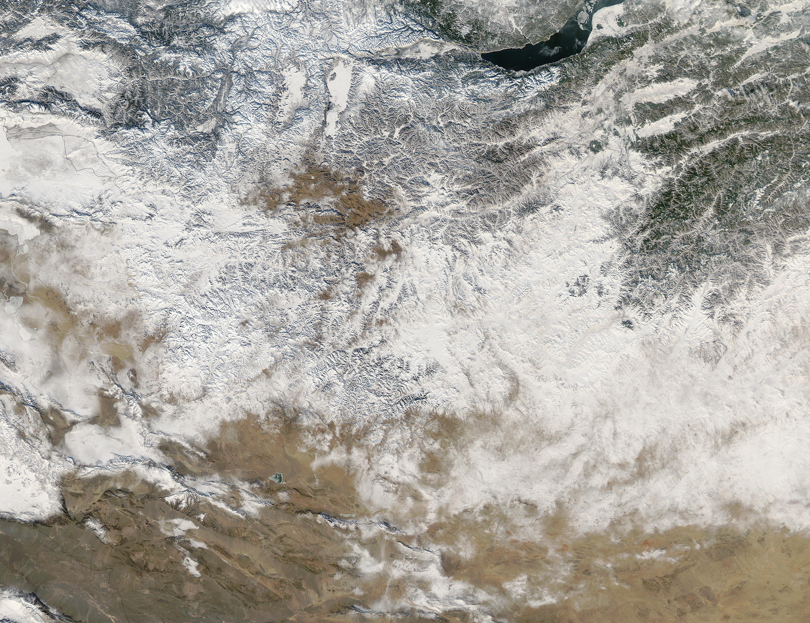
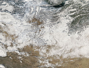 Snow covers Mongolia in patches in this image from December 21, 2003. Snowfall is normally light and blows away quickly during the winter, so to see this much snow on the ground at once is rather unusual.
Severe blizzards can occur in the region. The winters of 1970-1971, 2000–2001, 2008–2009 and 2009-2010 were particularly harsh.
The blizzards of December 2000 blocked many roads, and killed 16,000 livestock and 10 people.[1] .[2] The Mongolian State Emergency Commission said it was the coldest winter in 30 years and, like the preceding harsh summer drought[3] ,[4] could have been the result of global warming. The U.N. provided major aid due to the high level of damage caused.[5]
In the snowstorms between the 8 and 28 May 2008, 21 people were killed and 100 others went missing in seven provinces in eastern Mongolia.[6][7][8] The toll finally reached at least 52 people and 200,000 livestock by the end of June.[9] Most of the victims were herders who froze to death along with their livestock.[10] It was the worst cold snap since the founding of the modern state in 1922.
Snowstorms in December 2009 also killed 2,000 stock and 5 people.[11]
Ecoregions
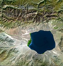 Endorheic lake in Northern Mongolia
- Altai montane forest and forest steppe
- Khangai Mountains conifer forests
- Selenge-Orkhon forest steppe
- Sayan montane conifer forests
- Trans-Baikal conifer forests
- Daurian forest steppe
- Mongolian-Manchurian grassland
- Altai alpine meadow and tundra
- Khangai Mountains alpine meadow
- Sayan Alpine meadows and tundra
- Alashan Plateau semi-desert
- Eastern Gobi desert steppe
- Gobi desert
- Gobi Lakes Valley desert steppe
- Great Lakes Basin desert steppe
- Junggar Basin semi-desert
Area and boundaries
Area:
total: 1.565 million km²
land: 1.565 million km²
water: 0 km²Area - comparative: slightly smaller than Alaska
Land boundaries:
total: 8,114 km
border countries: China 4,673 km, Russia 3,441 kmCoastline: 0 km (landlocked)
Maritime claims: none (landlocked)
Elevation extremes:
lowest point: Hoh Nuur 518 m
highest point: Hüiten Peak 4,374 mResources and land use
Natural resources: petroleum, coal, copper, molybdenum, tungsten, phosphates, tin, nickel, zinc, fluorspar, gold
Land use:
arable land: 1%
permanent crops: 0%
permanent pastures: 80%
forests and woodland: 9%
other: 10% (1993 est.)Irrigated land: 800 km² (1993 est.)
Antipodes
Much of central and western Mongolia, including Ulaanbaatar, is antipodal to southern Patagonia. See Geography of Chile#Antipodes and Geography of Argentina#Antipodes for details.
See also
- Mongolia
- List of reptiles of Mongolia
References
 This article incorporates public domain material from websites or documents of the Library of Congress Country Studies.
- This article incorporates public domain material from websites or documents of the CIA World Factbook.
External links
- (Mongolian) Administration of Land Affairs, Geodesy and Cartography
- (English) (Mongolian) Official government site - Institute of Meteorology and Hydrology
- (English) (Mongolian) Official government site - Mineral Resources Authority
- (English) (Mongolian) Official government site - Water Agency of Mongolia
- Limnological Catalogue of Mongolian Lakes
- GEOLOGY OF THE KHARKHIRAA UUL, MONGOLIAN ALTAI
Geography of Asia Sovereign
states- Afghanistan
- Armenia
- Azerbaijan
- Bahrain
- Bangladesh
- Bhutan
- Brunei
- Burma (Myanmar)
- Cambodia
- People's Republic of China
- Cyprus
- East Timor (Timor-Leste)
- Egypt
- Georgia
- India
- Indonesia
- Iran
- Iraq
- Israel
- Japan
- Jordan
- Kazakhstan
- North Korea
- South Korea
- Kuwait
- Kyrgyzstan
- Laos
- Lebanon
- Malaysia
- Maldives
- Mongolia
- Nepal
- Oman
- Pakistan
- Philippines
- Qatar
- Russia
- Saudi Arabia
- Singapore
- Sri Lanka
- Syria
- Tajikistan
- Thailand
- Turkey
- Turkmenistan
- United Arab Emirates
- Uzbekistan
- Vietnam
- Yemen
States with limited
recognition- Abkhazia
- Nagorno-Karabakh
- Northern Cyprus
- Palestine
- Republic of China (Taiwan)
- South Ossetia
Dependencies and
other territoriesClimate of Asia Sovereign
states- Afghanistan
- Armenia
- Azerbaijan
- Bahrain
- Bangladesh
- Bhutan
- Brunei
- Burma (Myanmar)
- Cambodia
- People's Republic of China
- Cyprus
- East Timor (Timor-Leste)
- Egypt
- Georgia
- India
- Indonesia
- Iran
- Iraq
- Israel
- Japan
- Jordan
- Kazakhstan
- North Korea
- South Korea
- Kuwait
- Kyrgyzstan
- Laos
- Lebanon
- Malaysia
- Maldives
- Mongolia
- Nepal
- Oman
- Pakistan
- Philippines
- Qatar
- Russia
- Saudi Arabia
- Singapore
- Sri Lanka
- Syria
- Tajikistan
- Thailand
- Turkey
- Turkmenistan
- United Arab Emirates
- Uzbekistan
- Vietnam
- Yemen
States with limited
recognition- Abkhazia
- Nagorno-Karabakh
- Northern Cyprus
- Palestine
- Republic of China (Taiwan)
- South Ossetia
Dependencies and
other territories- Christmas Island
- Cocos (Keeling) Islands
- Hong Kong
- Macau
Categories:


Wikimedia Foundation. 2010.