- Geography of Lebanon
-
Coordinates: 33°50′N 35°50′E / 33.833°N 35.833°E
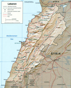 Detailed map of Lebanon, 2002
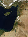
Lebanon stretches along the east side of the Mediterranean Sea, its length almost three times its width. As it stretches from North to South, the width of its terrain becomes narrower. Lebanon's mountainous terrain, proximity to the sea, and strategic location at a crossroads of the world were decisive factors in shaping its history. The political, economic, and religious movements that either originated in the region or crossed through to leave an imprint upon Lebanese society give form to that history.
The country's role in the region, as indeed in the world at large, was shaped by trade. The area, formerly part of the region known as Greater Syria, served as a link between the Mediterranean world and India and East Asia. The merchants of the region exported oil, grain, textiles, metal work, and pottery through the port cities to Western markets. The linkage role of Lebanon was further enhanced by the nomads of the Syrian and Arabian deserts who visited the cities of Syria to trade. The caravans developed limited routes that often led to the coastal cities of Tripoli, Beirut, Sidon, or Tyre. This created a merchant class and brought wealth to the inhabitants of the region. The trade between East and West led to the development of a cosmopolitan culture in Lebanon's port cities, whose inhabitants became known for their multilingualism, flexibility, moderation, and commercial acumen.
Lebanon was also affected by regional political conflicts and social movements. The wealth of the region attracted powerful rulers who coveted its resources. The strategic location was also attractive; it was used either as a defensive position against enemies approaching the Arab hinterland or as a stepping-stone toward Lebanon's neighbors. Over the centuries, members of the nomadic tribes of the Arabian Peninsula sought a more prosperous life in Lebanon. To this day, many Lebanese families take pride in tracing their descent to ancient tribes of Arabia. Moreover, refugees belonging to minority sects have settled in its virtually inaccessible mountain valleys. Hence, the region became a melting pot of cultural and/or social interaction among diverse groups. In a social culture where blood lineage assumed primacy as a source of identification and affiliation, the contrast between the new Arab immigrant tribes and the settled inhabitants of the land frequently produced conflicts. Also, Lebanon is part of Southwestern Asia, and it is located at about approximately 35˚N, 35˚W.
Contents
Land
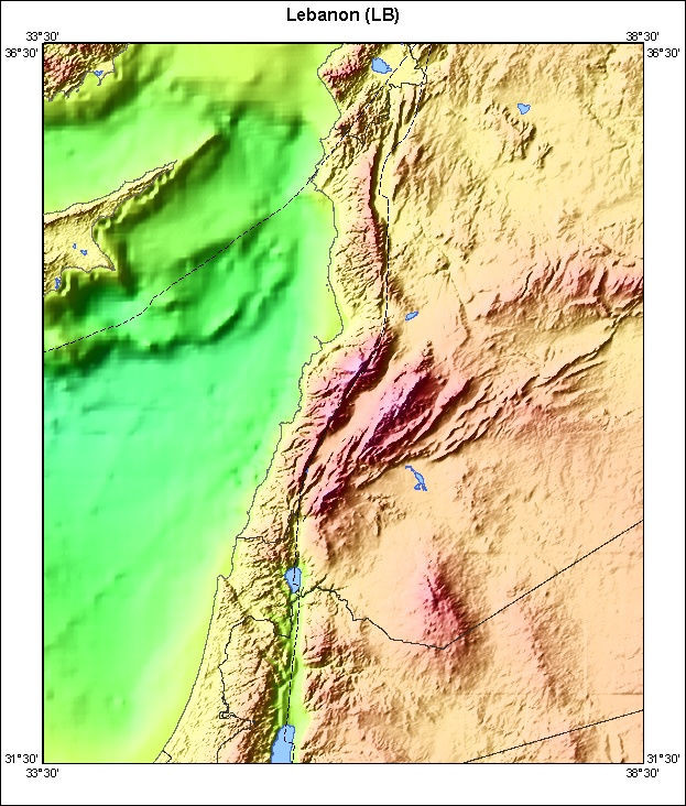
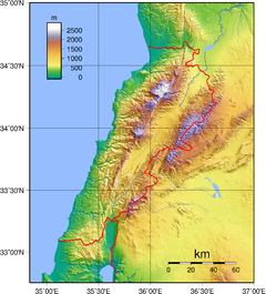 Topography of Lebanon
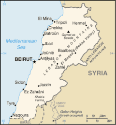
The area of Lebanon is approximately 10,452 square kilometers. The country is roughly rectangular in shape, becoming narrower toward the south and the farthest north. Its widest point is 88 kilometers, and its narrowest is 32 kilometers; the average width is about 56 kilometers.
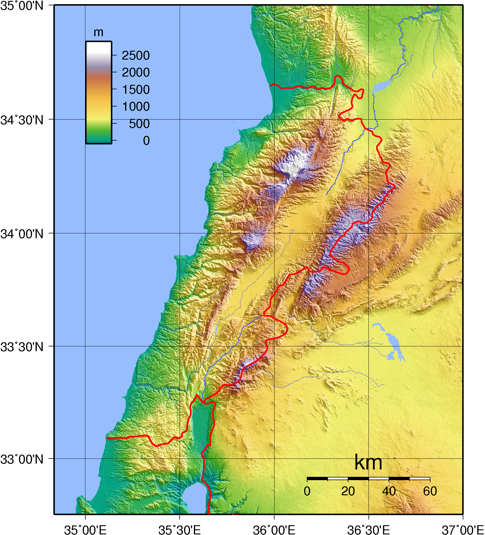
The physical geography of Lebanon is influenced by natural systems that extend outside the country. Thus, the Beqaa Valley is part of the Great Rift system, which stretches from southern Turkey to Mozambique in Africa. Like any mountainous country, Lebanon's physical geography is complex. Land forms, climate, soils, and vegetation differ markedly within short distances. There are also sharp changes in other elements of the environment, from good to poor soils, as one moves through the Lebanese mountains.
A major feature of Lebanese topography is the alternation of lowland and highland that runs generally parallel with a north-to-south orientation. There are four such longitudinal strips between the Mediterranean Sea and Syria: the coastal strip (or the maritime plain), western Lebanon, the central plateau, and eastern Lebanon (see fig. 3, Physical Features).
The extremely narrow coastal strip stretches along the shore of the eastern Mediterranean. Hemmed in between sea and mountain, the sahil, as it is called in Lebanon, is widest in the north near Tripoli, where it is only 6.5 kilometers wide. A few kilometers south at Juniyah the approximately 1.5-kilometer-wide plain is succeeded by foothills that rise steeply to 750 meters within 6.5 kilometers from the sea. For the most part, the coast is abrupt and rocky. The shoreline is regular with no deep estuary, gulf, or natural harbor. The maritime plain is especially productive of fruits and vegetables.
The western range, the second major region, is the Lebanon Mountains, sometimes called Mount Lebanon, or Lebanon proper before 1920. Since Roman days the term Mount Lebanon has encompassed this area. Antilibanos (Anti-Lebanon) was used to designate the eastern range. Geologists believe that the twin mountains once formed one range. The Lebanon Mountains are the highest, most rugged, and most imposing of the whole maritime range of mountains and plateaus that start with the Amanus or Nur Mountains in northern Syria and end with the towering massif of Sinai. The mountain structure forms the first barrier to communication between the Mediterranean and Lebanon's eastern hinterland. The mountain range is a clearly defined unit having natural boundaries on all four sides. On the north it is separated from the Nusayriyah Mountains of Syria by An Nahr al Kabir ("the great river"); on the south it is bounded by Al Qasimiyah River, giving it a length of 169 kilometers. Its width varies from about 56.5 kilometers near Tripoli to 9.5 kilometers on the southern end. It rises to alpine heights southeast of Tripoli, where Al Qurnat as Sawda ("the black nook") reaches 3,360 meters. Of the other peaks that rise east of Beirut, Jabal Sannin (2,695 meters) is the highest. Ahl al Jabal ("people of the mountain"), or simply jabaliyyun, has referred traditionally to the inhabitants of western Lebanon. Near its southern end, the Lebanon Mountains branch off to the west to form the Shuf Mountains.
The third geographical region is the Biqa Valley. This central highland between the Lebanon Mountains and the Anti-Lebanon Mountains is about 177 kilometers in length and 9.6 to 16 kilometers wide and has an average elevation of 762 meters. Its middle section spreads out more than its two extremities. Geologically, the Biqa is the medial part of a depression that extends north to the western bend of the Orontes River in Syria and south to Jordan through Al Arabah to Al Aqabah, the eastern arm of the Red Sea. The Biqa is the country's chief agricultural area and served as a granary of Roman Syria. Biqa is the Arabic plural of buqaah, meaning a place with stagnant water.
Emerging from a base south of Homs in Syria, the eastern mountain range, or Anti-Lebanon (Lubnan ash Sharqi), is almost equal in length and height to the Lebanon Mountains. This fourth geographical region falls swiftly from Mount Hermon to the Hawran Plateau, whence it continues through Jordan south to the Dead Sea. The Barada Gorge divides Anti-Lebanon. In the northern section, few villages are on the western slopes, but in the southern section, featuring Mount Hermon (286 meters), the western slopes have many villages. Anti-Lebanon is more arid, especially in its northern parts, than Mount Lebanon and is consequently less productive and more thinly populated? hi
Terrain
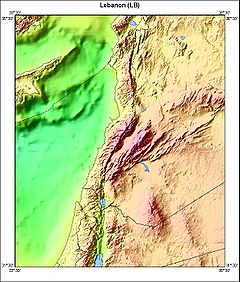 Bathymetric map of Lebanon
Divided into five ribbony topographical areas stretching vastly from North to South:
- The Shoreline. At 210 km (130.49 mi) long, it is mostly consisted of rocks towards north, and sand south, adding some headlands, bays, and offshore islands
- The Coastal plain. Surrounded by sea and mountains, it is rather narrow at 2 or 3 km (1.86 mi) wide
- Mount Lebanon (the West Mountains).
- Beqaa valley.
- Anti-Lebanon (the East Mountains).
Climate

Lebanon has a Mediterranean climate characterized by a long, hot, and dry summer, and cool, rainy winter. Fall is a transitional season with a gradual lowering of temperature and little rain; spring occurs when the winter rains cause the vegetation to revive. Topographical variation creates local modifications of the basic climatic pattern. Along the coast, summers are hot and humid, with little or no rain. Heavy dews form, which are beneficial to agriculture. The daily range of temperature is not wide. A west wind provides relief during the afternoon and evening; at night the wind direction is reversed, blowing from the land out to sea.
Winter is the rainy season, with major precipitation falling after December. Rainfall is generous but is concentrated during only a few days of the rainy season, falling in heavy cloudbursts. The amount of rainfall varies greatly from one year to another. Occasionally, there are frosts during the winter, and about once every fifteen years a light powdering of snow falls as far south as Beirut. A hot wind blowing from the Egyptian desert called the khamsin (Arabic for "fifty"), may provide a warming trend during the fall, but more often occurs during the spring. Bitterly cold winds may have come from Europe. Along the coast the proximity to the sea provides a moderating influence on the climate, making the range of temperatures narrower than it is inland, but the temperatures are cooler in the northern parts of the coast where there is also more rain.
In the Lebanon Mountains the gradual increase in altitude produces colder winters with more precipitation and snow. The summers have a wider daily range of temperatures and less humidity. In the winter, frosts are frequent and snows heavy; in fact, snow covers the highest peaks for much of the year. In the summer, temperatures may rise as high during the daytime as they do along the coast, but they fall far lower at night. Inhabitants of the coastal cities, as well as visitors, seek refuge from the oppressive humidity of the coast by spending much of the summer in the mountains, where numerous summer resorts are located. Both the khamsin and the north winter wind are felt in the Lebanon Mountains. The influence of the Mediterranean Sea is abated by the altitude and, although the precipitation is even higher than it is along the coast, the range of temperatures is wider and the winters are more severe.
The Biqa Valley and the Anti-Lebanon Mountains are shielded from the influence of the sea by the Lebanon Mountains. The result is considerably less precipitation and humidity and a wider variation in daily and yearly temperatures. The khamsin does not occur in the Biqa Valley, but the north winter wind is so severe that the inhabitants say it can "break nails." Despite the relatively low altitude of the Biqa Valley (the highest point of which, near Baalbek, is only 1,100 meters / 3,609 feet) more snow falls there than at comparable altitudes west of the Lebanon Mountains.
Because of their altitudes, the Anti-Lebanon Mountains receive more precipitation than the Biqa Valley, despite their remoteness from maritime influences. Much of this precipitation appears as snow, and the peaks of the Anti-Lebanon, like those of the Lebanon Mountains, are snow-covered for much of the year. Temperatures are cooler than in the Biqa Valley.
The Biqa Valley is watered by two rivers that rise in the watershed near Baalbek: the Orontes flowing north (in Arabic it is called Nahr al Asi, "the Rebel River", because this direction is unusual), and the Litani flowing south into the hill region of the southern Biqa Valley, where it makes an abrupt turn to the west in southern Lebanon and is thereafter called the Al Qasmiyah River. The Orontes continues to flow north into Syria and eventually reaches the Mediterranean in Turkey. Its waters, for much of its course, flow through a channel considerably lower than the surface of the ground. The Nahr Barada, which waters Damascus, has as its source a spring in the Anti-Lebanon Mountains.
Smaller springs and streams serve as tributaries to the principal rivers. Because the rivers and streams have such steep gradients and are so fast moving, they are erosive instead of depository in nature. This process is aided by the soft character of the limestone that composes much of the mountains, the steep slopes of the mountains, and the heavy rainstorms. The only permanent lake is Buhayrat al Qirawn, about ten kilometers east of Jezzine. There is one seasonal lake, fed by springs, on the eastern slopes of the Lebanon Mountains near Yammunah, about 40 kilometres (25 mi) southeast of Tripoli.
-
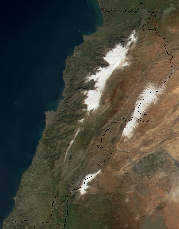
Snow covered karstic formations in the Danniyeh mountains.
-

Lebanon from space. Snow cover can be seen on the western and eastern mountain ranges.
-
Snow in Lebanon’s two mountain ranges, Jebel Liban and Jabal ash Sharqi in March 2011.
Area and boundaries
total: 10,452 km2 (4,036 sq mi)
land: 10,280 km2 (3,969 sq mi)
water: 170 km2 (66 sq mi)Land boundaries:
total: 454 km (282 mi)
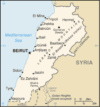
border countries: Israel 79 km (49.1 mi), Syria 375 km (233 mi)Coastline: 210 km (130 mi)
Maritime claims: territorial sea: 12 nmi (22.2 km; 13.8 mi)
Elevation extremes:
lowest point: Mediterranean Sea 0 m (0 ft) (sea level)
highest point: Qurnat as Sawda' 3,088 m (10,131 ft)Resources and land use
Limestone, iron ore, salt, water-surplus state in a water-deficit region, arable land
arable land: 21%
permanent crops: 9%
permanent pastures: 1%
forests and woodland: 8%
other: 61% (1993 est.)Irrigated land: 860 km2 (332.05 sq mi) (1993 est.)
Environmental concerns
Natural hazards include dust storms.
Current environmental degradation concerns include deforestation, soil erosion, desertification, air pollution in Beirut from vehicular traffic and the burning of industrial wastes, and pollution of coastal watboundary. Lebanon's rugged terrain historically helped isolate, protect, and develop numerous factional groups based on religion, clan, and ethnicity.
References
 This article incorporates public domain material from websites or documents of the Library of Congress Country Studies.
Geography of Asia Sovereign
statesAfghanistan · Armenia · Azerbaijan · Bahrain · Bangladesh · Bhutan · Brunei · Burma (Myanmar) · Cambodia · People's Republic of China · Cyprus · East Timor (Timor-Leste) · Egypt · Georgia · India · Indonesia · Iran · Iraq · Israel · Japan · Jordan · Kazakhstan · North Korea · South Korea · Kuwait · Kyrgyzstan · Laos · Lebanon · Malaysia · Maldives · Mongolia · Nepal · Oman · Pakistan · Philippines · Qatar · Russia · Saudi Arabia · Singapore · Sri Lanka · Syria · Tajikistan · Thailand · Turkey · Turkmenistan · United Arab Emirates · Uzbekistan · Vietnam · Yemen
States with limited
recognitionAbkhazia · Nagorno-Karabakh · Northern Cyprus · Palestine · Republic of China (Taiwan) · South Ossetia
Dependencies and
other territoriesClimate of Asia Sovereign
statesAfghanistan · Armenia · Azerbaijan · Bahrain · Bangladesh · Bhutan · Brunei · Burma (Myanmar) · Cambodia · People's Republic of China · Cyprus · East Timor (Timor-Leste) · Egypt · Georgia · India · Indonesia · Iran · Iraq · Israel · Japan · Jordan · Kazakhstan · North Korea · South Korea · Kuwait · Kyrgyzstan · Laos · Lebanon · Malaysia · Maldives · Mongolia · Nepal · Oman · Pakistan · Philippines · Qatar · Russia · Saudi Arabia · Singapore · Sri Lanka · Syria · Tajikistan · Thailand · Turkey · Turkmenistan · United Arab Emirates · Uzbekistan · Vietnam · Yemen
States with limited
recognitionAbkhazia · Nagorno-Karabakh · Northern Cyprus · Palestine · Republic of China (Taiwan) · South Ossetia
Dependencies and
other territoriesChristmas Island · Cocos (Keeling) Islands · Hong Kong · Macau
 Lebanon topics
History 
Politics Constitution · President · Prime Minister · Political parties · Foreign relations · Military · Human rights (LGBT rights)Geography Mount Lebanon · Beqaa · Anti-Lebanon mountains · Cities · Governates · Districts · South Lebanon · Sheeba FarmsEconomy Central Bank · Transport · Tourism · Communications · Agriculture · International rankings · Lebanese PoundCulture WikiProject Lebanon Categories:


Wikimedia Foundation. 2010.