- Geography of Vietnam
-
For historical geography of Vietnam, see History of Vietnam.
 Vietnam's cities and towns
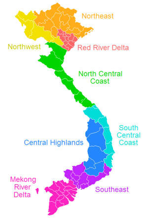
 Regions of Vietnam
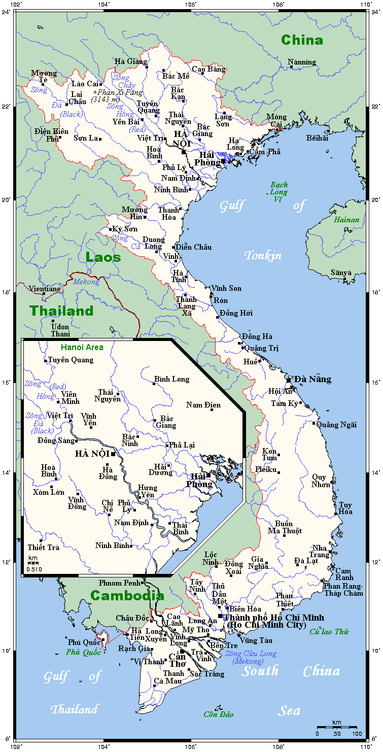
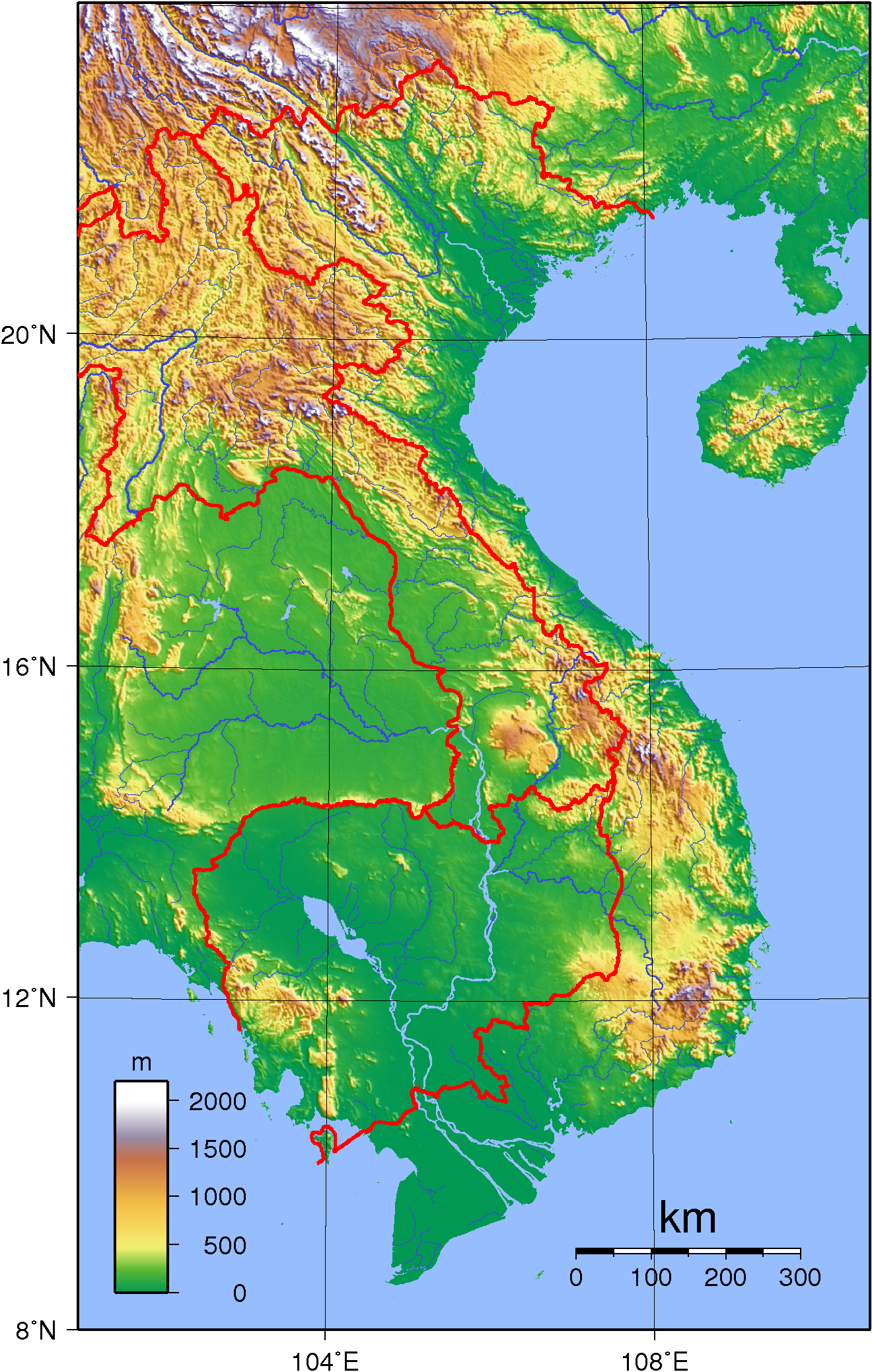
 Topographic map of Vietnam
Vietnam is located on the eastern margin of the Indochinese peninsula and occupies about 331,688 square kilometers, of which about 25 % was under cultivation in 1987. It borders the Gulf of Thailand, Gulf of Tonkin, and South China Sea, alongside China, Laos, and Cambodia. The S-shaped country has a north-to-south distance of 1,650 kilometers and is about 50 kilometers wide at the narrowest point. With a coastline of 3,260 kilometers, excluding islands, Vietnam claims 12 nautical miles (22.2 km; 13.8 mi) as the limit of its territorial waters, an additional 12 nautical miles (22.2 km; 13.8 mi) as a contiguous customs and security zone, and 200 nautical miles (370.4 km; 230.2 mi) as an exclusive economic zone.
The boundary with Laos, settled, on both an ethnic and geographical basis, between the rulers of Vietnam and Laos in the mid-seventeenth century with the Annamite Range as a reference, was formally defined by a delimitation treaty signed in 1977 and ratified in 1986. The frontier with Cambodia, defined at the time of French annexation of the western part of the Mekong River Delta in 1867, remained essentially unchanged, according to Hanoi, until some unresolved border issues were finally settled in the 1982-85 period. The land and sea boundary with China, delineated under the France-China treaties of 1887 and 1895, is "the frontier line" accepted by Hanoi that China agreed in 1957- 58 to respect. However, in February 1979, following China's limited invasion of Vietnam, Hanoi complained that from 1957 onward China had provoked numerous border incidents as part of its anti-Vietnam policy and expansionist designs in Southeast Asia. Among the territorial infringements cited was the Chinese occupation in January 1974 of the Paracel Islands, claimed by both countries in a dispute left unresolved in the 1980s.
Coordinates: 16°00′N 108°00′E / 16°N 108°E
Contents
Physiography
Vietnam is a country of tropical lowlands, hills, and densely forested highlands, with level land covering no more than 20% of the area. The country is divided into the highlands and the Red River delta in the north; and the Giai Truong Son (Central mountains, or the Chaîne Annamitique, sometimes referred to simply as "the Chaine."), the coastal lowlands, and the Mekong River Delta in the south.
The spectacular Ban Gioc Waterfall is 272 km north of Hanoi and few tourists are seen there. [1]
See also: Provinces of VietnamRed River Delta
The Red River Delta (also known as the Sông Hồng), is a flat, triangular region of 15,000 square kilometers,[2] is smaller but more intensely developed and more densely populated than the Mekong River Delta. Once an inlet of the Gulf of Tonkin, it has been filled in by the enormous alluvial deposits of the rivers over a period of millennia, and it advances one hundred meters into the Gulf annually[citation needed]. The ancestral home of the ethnic Vietnamese, the delta accounted for almost 70 % of the agriculture and 80 % of the industry of North Vietnam before 1975.
The Red River, rising in China's Yunnan province, is about 1,200 kilometers long. Its two main tributaries, the Sông Lô (also called the Lo River, the Riviere Claire, or the Clear River) and the Sông Da (also called the Black River or Riviere Noire), contribute to its high water volume, which averages 4,300 cubic meters per second.[3] The entire delta region, backed by the steep rises of the forested highlands, is no more than three meters above sea level, and much of it is one meter or less. The area is subject to frequent flooding; at some places the high-water mark of floods is fourteen meters above the surrounding countryside. For centuries flood control has been an integral part of the delta's culture and economy. An extensive system of dikes and canals has been built to contain the Red River and to irrigate the rich rice-growing delta. Modeled on that of China's, this ancient system has sustained a highly concentrated population and has made double-cropping wet-rice cultivation possible throughout about half the region.
Highlands
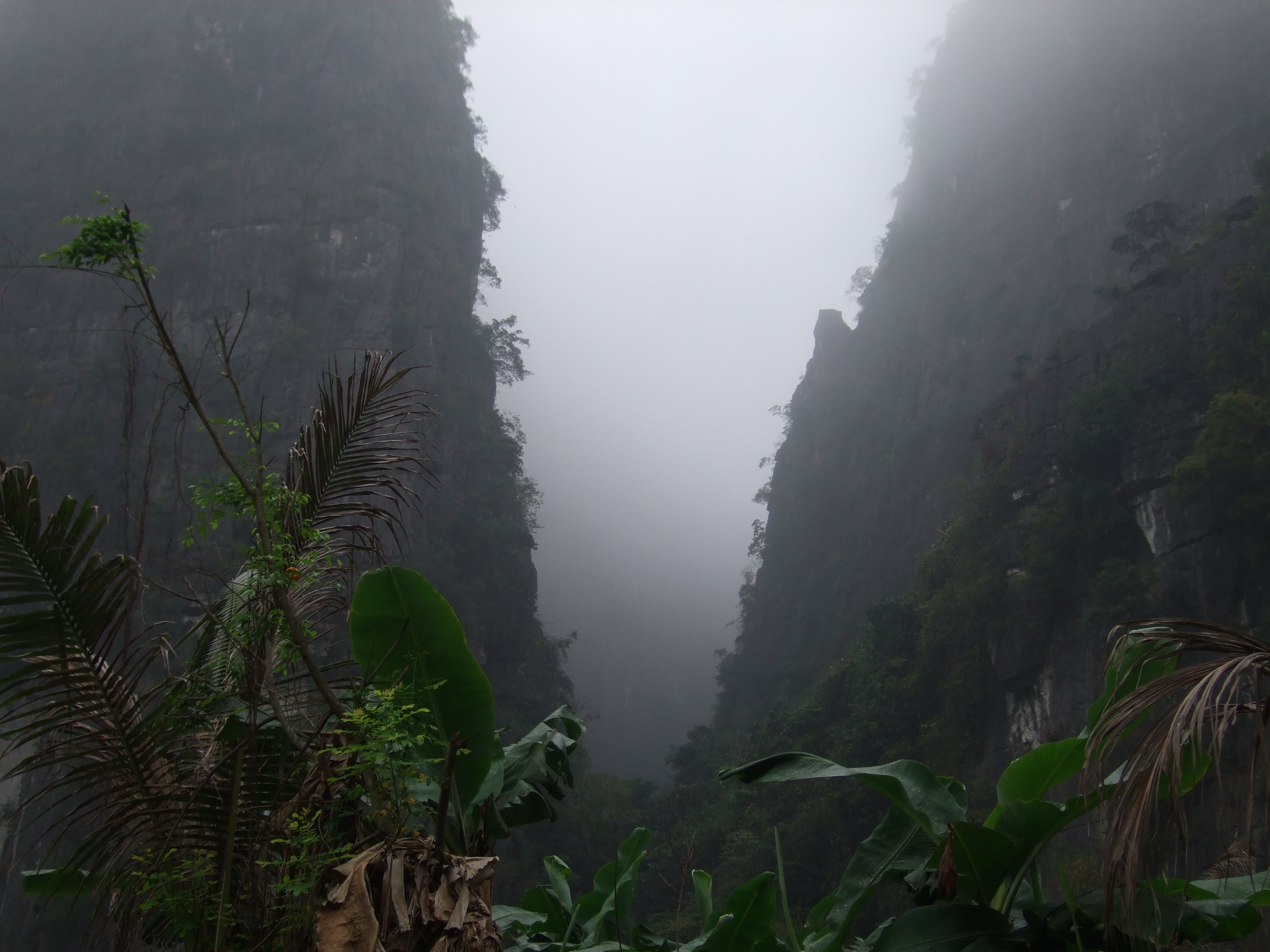
See also: Zomia (geography)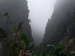 A valley in the north.
The highlands and mountain plateaus in the north and northwest are inhabited mainly by tribal minority groups. The Day Truong Son (Annamite Range) originates in the Tibetan and Yunnan regions of southwest China and forms Vietnam's border with Laos and Cambodia. It terminates in the Mekong River Delta north of Hồ Chí Minh City (formerly Saigon).
These central mountains, which have several high plateaus, are irregular in elevation and form. The northern section is narrow and very rugged; the country's highest peak, Fan Si Pan, rises to 3,142 meters in the extreme northwest. The southern portion has numerous spurs that divide the narrow coastal strip into a series of compartments. For centuries these topographical features not only rendered north-south communication difficult but also formed an effective natural barrier for the containment of the people living in the Mekong basin.
Central Highlands
See also: Zomia (geography)Within the southern portion of Vietnam is a plateau known as the Central Highlands (Tay Nguyen), approximately 51,800 square kilometers of rugged mountain peaks, extensive forests, and rich soil. Comprising 5 relatively flat plateaus of basalt soil spread over the provinces of Đắk Lắk (or "Dac Lac"), Gia Lai, and Kon Tom, the highlands account for 16% of the country's arable land and 22% of its total forested land. Before 1975, North Vietnam had maintained that the Central Highlands and the Giai Truong Son were strategic areas of paramount importance, essential to the domination not only of South Vietnam but also of the southern part of Indochina. Since 1975, the highlands have provided an area in which to relocate people from the densely populated lowlands.
Coastal lowlands
The narrow, flat coastal lowlands extend from south of the Red River Delta to the Mekong River basin. On the landward side, the Giai Truong Son rises precipitously above the coast, its spurs jutting into the sea at several places. Generally the coastal strip is fertile and rice is cultivated intensively.
Mekong River Delta
The Mekong river delta or Mekong delta, covering about 40,000 square kilometers, is a low-level plain not more than three meters above sea level at any point and criss-crossed by a maze of canals and rivers. So much sediment is carried by the Mekong's various branches and tributaries that the delta advances sixty to eighty meters into the sea every year. An official Vietnamese source estimates the amount of sediment deposited annually to be about 1 billion cubic meters, or nearly 13 times the amount deposited by the Red River. About 10,000 square kilometers of the delta are under rice cultivation, making the area one of the major rice-growing regions of the world. The southern tip, known as the Cà Mau Peninsula is covered by dense jungle and mangrove swamps.
The Mekong, which is 4,220 kilometers long, is one of the 12 great rivers of the world. From its source in the Tibetan plateau, it flows through the Tibetan and Yunnan regions of China, forms the boundary between Laos and Myanmar as well as between Laos and Thailand. At Phnom Penh it merges with the Tonle Sap and divides into two branches - the Song Hau Giang (known as the Bassac River on the Cambodian side) and the Song Tien Giang - and continues through Cambodia and the Mekong basin before draining into the South China Sea through nine mouths known as the cuu long (nine dragons). The river is heavily silted and is navigable by seagoing craft of shallow draft as far as Kompong Cham in Cambodia. A tributary entering the river at Phnom Penh drains the Tonlé Sap, a shallow freshwater lake that acts as a natural reservoir to stabilize the flow of water through the lower Mekong. When the river is in flood stage, its silted delta outlets are unable to carry off the high volume of water. Floodwaters back up into the Tonlé Sap, causing the lake to inundate as much as 10,000 square kilometers. As the flood subsides, the flow of water reverses and proceeds from the lake to the sea. The effect is to reduce significantly the danger of devastating floods in the Mekong delta, where the river floods the surrounding fields each year to a level of one to two meters.
Climate
See also: ClimateVietnam Climate chart (explanation) J F M A M J J A S O N D 19201227211339241880292119832222403325322322634532252503124992823442519212116Average max. and min. temperatures in °C Precipitation totals in mm Source: "The Climate of Vietnam". The Embassy of the Socialist Republic of Vietnam in the United Kingdom.. http://www.vietnamembassy.org.uk/climate.html. Imperial conversion J F M A M J J A S O N D 0.768541.170551.575643.184707.890729.491771390791490779.888753.982731.777660.87061Average max. and min. temperatures in °F Precipitation totals in inches Vietnam in the northern regions have a humid subtropical climate, with humidity averaging 84% throughout the year. However, because of differences in latitude and the marked variety of topographical relief, the climate tends to vary considerably from place to place. During the winter or dry season, extending roughly from November to April, the monsoon winds usually blow from the northeast along the China coast and across the Gulf of Tonkin, picking up considerable moisture; consequently the winter season in most parts of the country is dry only by comparison with the rainy or summer season. During the southwesterly summer monsoon, occurring from May to October, the heated air of the Gobi Desert rises, far to the north, inducing moist air to flow inland from the sea and deposit heavy rainfall. The climate in the southern regions especially Ho Chi Minh City and surrounding Mekong Delta is predominantly Tropical savanna climate with high humidity and a distinct wet and dry season.
Annual rainfall is substantial in all regions and torrential in some, ranging from 1,200 to 3,000 millimeters (47.2 to 118.1 in). Nearly 90% of the precipitation occurs during the summer. The average annual temperature is generally higher in the plains than in the mountains and plateaus. Temperatures range from a low of 5 °C (41 °F) in December and January, the coolest months, to more than 37 °C (98.6 °F) in April, the hottest month. Seasonal divisions are more clearly marked in the northern half than in the southern half of the country, where, except in some of the highlands, seasonal temperatures vary only a few degrees, usually in the 21–28 °C (69.8–82.4 °F) range.
Area and boundaries
Area:
- total: 329 560 km²
- land: 325 360 km²
- water: 4 200 km²
Area - comparative:
- slightly larger than the state of New Mexico in the United States.
- slightly smaller than Newfoundland and Labrador, Canada.
- somewhat less than half as big asNew South Wales, Australia.
- about 1⅓ times the United Kingdom's size.
Land Boundaries:
- total: 4 639 km
- border countries: Cambodia (1 228 km), China (1 281 km), Laos (2 130 km)
Coastline: 3 444 km (excludes islands)
Maritime Claims:
- contiguous zone: 24 nmi (44.4 km; 27.6 mi)
- continental shelf: 200 nmi (370.4 km; 230.2 mi) or to the edge of the continental margin
- exclusive economic zone: 200 nmi (370.4 km; 230.2 mi)
- territorial sea: 12 nmi (22.2 km; 13.8 mi)
Elevation extremes:
- lowest point: South China Sea 0 m
- highest point: Fansipan 3 143 m
Resources and land use
Natural resources: phosphates, coal, manganese, bauxite, chromate, offshore oil and gas deposits, forests, hydropower
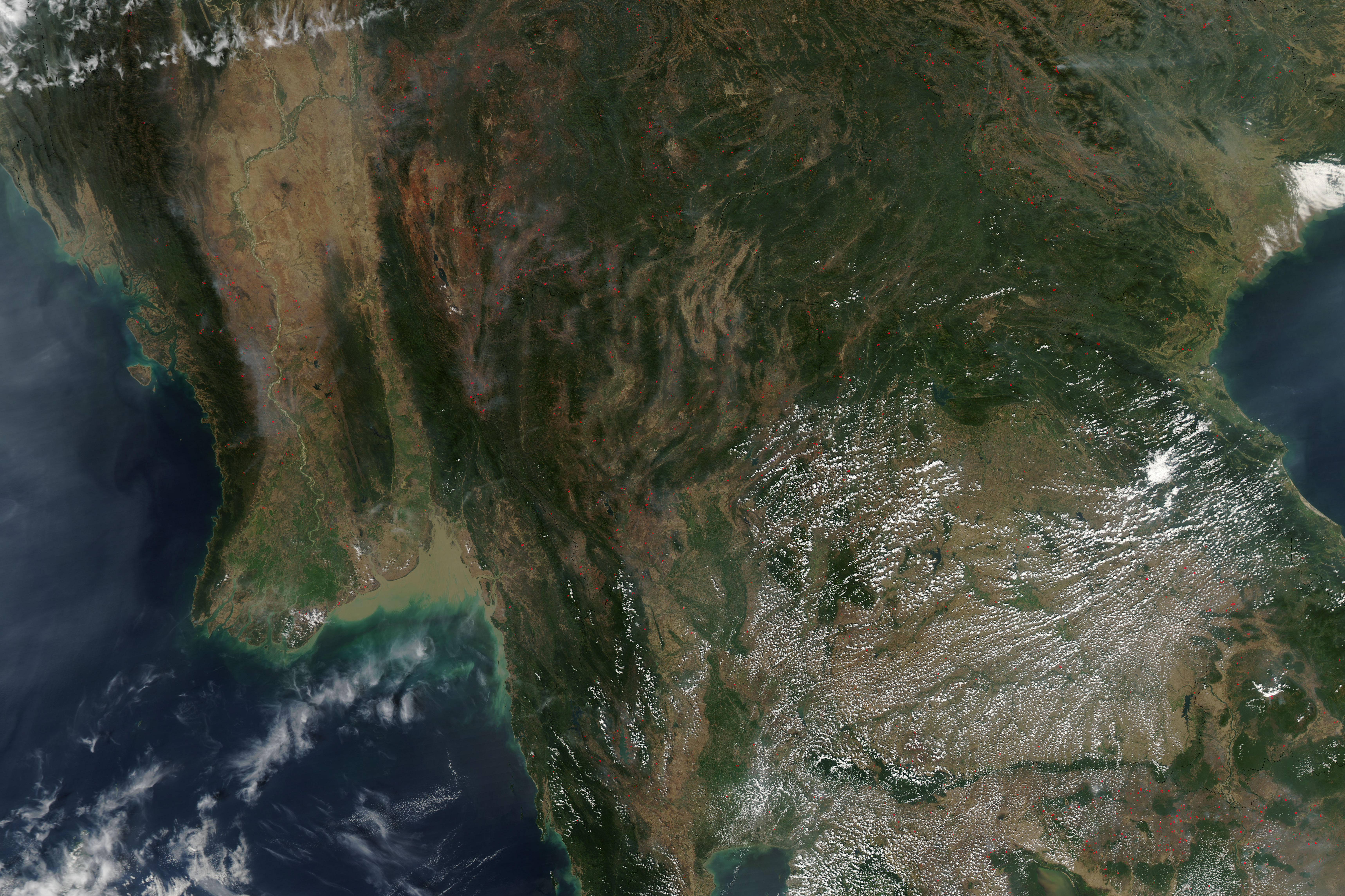
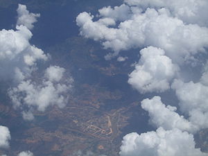 Aerial view of land use in Vietnam.
Land use:
- arable land: 17%
- permanent crops: 4%
- permanent pastures: 1%
- forests and woodland: 30%
- other: 48% (1993 est.)
Irrigated land: 18,600 km² (1993 est.)
Environmental concerns
Natural hazards: occasional typhoons (May to January) with extensive flooding
Environment - current issues:
Logging and slash-and-burn agricultural practices contribute to deforestation and soil degradation; water pollution and overfishing threaten marine life populations; groundwater contamination limits potable water supply; growing urbanization and human migration are rapidly degrading environment in Hanoi and Hồ Chí Minh City
Environment - international agreements:
party to: Biodiversity, Climate Change, Desertification, Endangered Species, Environmental Modification, Hazardous Wastes, Law of the Sea, Ozone Layer Protection, Ship Pollution (MARPOL 73/78), Wetlands, Climate Change-Kyoto Protocol, Nuclear Test Ban
See also
- Vietnam
- Halong Bay
- List of endangered species in Vietnam
- Zomia (geography)
References
- ^ "Vietnam Destinations: Ban Gioc (Cao Bang)". http://www.smile.com.vn/vietnam_destinations/vietnam_destinations_travel_tours_cao_bang_ban_gioc.htm. Retrieved 2007-02-12.
- ^ Agroviet Newsletter September 2005
- ^ "State of water: Vietnam.". Water Environment Partnership in Asia. http://www.wepa-db.net/policies/state/vietnam/surface.htm. Retrieved 2008-03-26.
Sources
 This article incorporates public domain material from websites or documents of the Library of Congress Country Studies.
- This article incorporates public domain material from websites or documents of the CIA World Factbook.
 Vietnam topics
History Politics Government ExecutiveLegislativeEconomy Agriculture · Doi Moi · Five-Year Plans · International rankings · Manufacturing · Tourism · Vietnamese dong (VND)Transport Geography Society Arts Other topics Communications · National flag / coat of arms · Provinces · Diaspora · Human rights (LGBT rights) · Vietnamese studiesPortal · WikiProject · Outline Geography of Asia Sovereign
states- Afghanistan
- Armenia
- Azerbaijan
- Bahrain
- Bangladesh
- Bhutan
- Brunei
- Burma (Myanmar)
- Cambodia
- People's Republic of China
- Cyprus
- East Timor (Timor-Leste)
- Egypt
- Georgia
- India
- Indonesia
- Iran
- Iraq
- Israel
- Japan
- Jordan
- Kazakhstan
- North Korea
- South Korea
- Kuwait
- Kyrgyzstan
- Laos
- Lebanon
- Malaysia
- Maldives
- Mongolia
- Nepal
- Oman
- Pakistan
- Philippines
- Qatar
- Russia
- Saudi Arabia
- Singapore
- Sri Lanka
- Syria
- Tajikistan
- Thailand
- Turkey
- Turkmenistan
- United Arab Emirates
- Uzbekistan
- Vietnam
- Yemen
States with limited
recognition- Abkhazia
- Nagorno-Karabakh
- Northern Cyprus
- Palestine
- Republic of China (Taiwan)
- South Ossetia
Dependencies and
other territoriesClimate of Asia Sovereign
states- Afghanistan
- Armenia
- Azerbaijan
- Bahrain
- Bangladesh
- Bhutan
- Brunei
- Burma (Myanmar)
- Cambodia
- People's Republic of China
- Cyprus
- East Timor (Timor-Leste)
- Egypt
- Georgia
- India
- Indonesia
- Iran
- Iraq
- Israel
- Japan
- Jordan
- Kazakhstan
- North Korea
- South Korea
- Kuwait
- Kyrgyzstan
- Laos
- Lebanon
- Malaysia
- Maldives
- Mongolia
- Nepal
- Oman
- Pakistan
- Philippines
- Qatar
- Russia
- Saudi Arabia
- Singapore
- Sri Lanka
- Syria
- Tajikistan
- Thailand
- Turkey
- Turkmenistan
- United Arab Emirates
- Uzbekistan
- Vietnam
- Yemen
States with limited
recognition- Abkhazia
- Nagorno-Karabakh
- Northern Cyprus
- Palestine
- Republic of China (Taiwan)
- South Ossetia
Dependencies and
other territories- Christmas Island
- Cocos (Keeling) Islands
- Hong Kong
- Macau
Categories:

Wikimedia Foundation. 2010.