- Geography of the Philippines
Country geography
name = the Philippines
continent =Asia
region =Southeast Asia
coordinates = 13°00'N 122°00'E
area ranking = 72nd
km area = 300000
percent land = 99.38
km coastline = 36289
borders = None
northernmost point =Y'Ami island
southernmost point =Saluag Island of Sibutu Islands
easternmost point =Pusan Point , Davao Oriental
westernmost point =Spratlys
112°00'E
geographic center =
highest point =Mount Apo
2,954 m (9,691 ft)
lowest point =Philippine Sea
0 m/0 ft (sea level )
longest river =Cagayan River
largest lake =Laguna de Bay
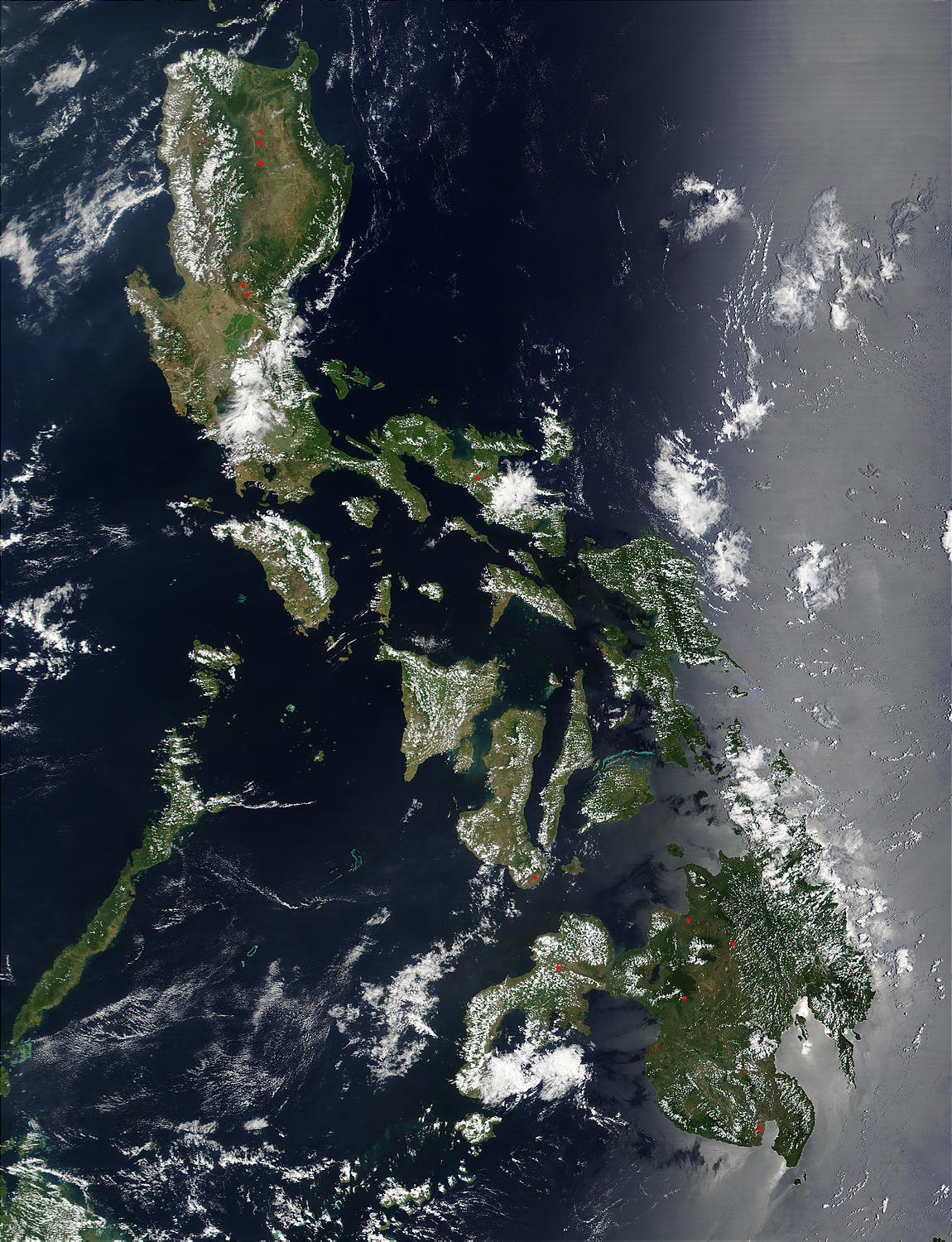
ThePhilippines is an archipelago comprising 7,107 islands with a total land area of 300,000 km². The 11 largest islands contain 94% of the total land area. The largest of these islands isLuzon at about 105,000 km². The next largest island isMindanao at about 95,000 km². The archipelago is around 800 km from theAsia n mainland and is located betweenTaiwan andBorneo .The islands are divided into three groups:
Luzon ,Visayas , andMindanao . The Luzon islands include Luzon itself,Mindoro ,Marinduque ,Masbate andBatanes Islands ,Palawan ,. The Visayas is the group of islands in the central Philippines, the largest of which are: Panay,Negros , Cebu,Bohol , Leyte and Samar. The Mindanao islands include Mindanao itself, plus theSulu Archipelago , composed primarily ofBasilan ,Sulu , andTawi-Tawi .Physical setting
The Philippine archipelago lies in Southeast Asia in a position that has led to its becoming a cultural crossroads, a place where Malays, Arabs, Chinese, Spaniards, Americans, Japanese and others have interacted to forge a unique cultural and racial blend. The archipelago numbers some 7,107 islands and the nation claims an
exclusive economic zone (EEZ) of convert|200|nmi|km from its shores. The Philippines occupies an area that stretches for 1,850 kilometers from about the fifth to the twentieth parallels north latitude. The total land area is slightly more than 300,000 square kilometers. Only approximately 1,000 of its islands are populated, and fewer than one-half of these are larger than 2.5 square kilometers. Eleven islands make up 95 percent of the Philippine landmass, and two of these — Luzon and Mindanao — measure 105,000 and 95,000 square kilometers, respectively. They, together with the cluster of the Visayan Islands that separate them, represent the three principal regions of the archipelago that are identified by the three stars on thePhilippine flag . Topographically, the Philippines is broken up by the sea, which gives it one of the longest coastlines of any nation in the world. Most Filipinos live on or near the coast, where they can easily supplement their diet from approximately 2,000 species of fish.Off the coast of eastern Mindanao is the Philippine Trough, which descends to a depth of 10,430 meters. The Philippines is part of a western Pacific arc system that is characterized by active volcanoes. Among the most notable peaks are
Mount Mayon nearLegazpi City ,Taal Volcano south ofManila , andMount Apo on Mindanao. All of the Philippine islands are prone to earthquakes. The northern Luzon highlands, or Cordillera Central, rise to between 2,500 and 2,750 meters, and, together with the Sierra Madre in the northeastern portion of Luzon and the mountains of Mindanao, boast rain forests that provide refuge for numerous upland tribal groups. The rain forests also offer prime habitat for more than 500 species of birds, including thePhilippine eagle (or monkey-eating eagle), some 800 species of orchids, and some 8,500 species of flowering plants.The country's most extensive river systems are the
Pulangi River , which flows into theMindanao River (Rio Grande de Mindanao); the Agusan, in Mindanao which flows north into theMindanao Sea ; the Cagayan in northern Luzon; and the Pampanga, which flows south from east Central Luzon intoManila Bay .Laguna de Bay , east of Manila Bay, is the largest freshwater lake in the Philippines. Several rivers have been harnessed for hydroelectric power.To protect the country's biological resources, the government has taken a first step of preparing a
Biodiversity Action Plan to address conservation of threatenedspecies .Political geography
The Philippines is divided into a hierarchy of local government units (LGUs) with the 81 provinces as the primary unit. Provinces are further subdivided into cities and municipalities, which are in turn composed of
barangay s. The barangay is the smallest local government unit.The Philippines is divided into 178,000 regions with all provinces grouped into one of 16 regions for administrative convenience. The National Capital Region however, is divided into four special districts.
Most government offices establish regional offices to serve the constituent provinces. The regions themselves do not possess a separate local government, with the exception of the
Autonomous Region in Muslim Mindanao .Regions
*
Ilocos Region (Region I)
*Cagayan Valley (Region II)
*Central Luzon (Region III)
*Calabarzon (Region IV-A)
*Mimaropa (Region IV-B)
*Bicol Region (Region V)
*Western Visayas (Region VI)
*Central Visayas (Region VII)
*Eastern Visayas (Region VIII)
*Zamboanga Peninsula (Region IX)
*Northern Mindanao (Region X)
*Davao Region (Region XI)
* Soccsksargen (Region XII)
*Caraga (Region XIII)
*Autonomous Region in Muslim Mindanao (ARMM)
*Cordillera Administrative Region (CAR)
* National Capital Region (NCR; Metro Manila)Provinces
*Abra
*Agusan del Norte
*Agusan del Sur
*Aklan
*Albay
*Antique
*Apayao
*Aurora
*Basilan
*Bataan
*Batanes
*Batangas
*Benguet
*Biliran
*Bohol
*Bukidnon
*Bulacan
*Cagayan
*Camarines Norte
*Camarines Sur
*Camiguin
*Capiz
*Catanduanes
*Cavite
*Cebu
*Compostela Valley
*Cotabato
*Davao del Norte
*Davao del Sur
*Davao Oriental
*Dinagat Islands
*Eastern Samar
*Guimaras
*Ifugao
*Ilocos Norte
*Ilocos Sur
*Iloilo
*Isabela
*Kalinga
*La Union
*Laguna
*Lanao del Norte
*Lanao del Sur
*Leyte
*Maguindanao
*Marinduque
*Masbate
*Misamis Occidental
*Misamis Oriental
*Mountain Province
*Negros Occidental
*Negros Oriental
*Northern Samar
*Nueva Ecija
*Nueva Vizcaya
*Occidental Mindoro
*Oriental Mindoro
*Palawan
*Pampanga
*Pangasinan
*Quezon
*Quirino
*Rizal
*Romblon
*Samar
*Sarangani
*Siquijor
*Shariff Kabunsuan
*Sorsogon
*South Cotabato
*Southern Leyte
*Sultan Kudarat
*Sulu
*Surigao del Norte
*Surigao del Sur
*Tarlac
*Tawi-Tawi
*Zambales
*Zamboanga del Norte
*Zamboanga del Sur
*Zamboanga Sibugay List of Landlocked provinces in the Philippines
A
landlocked province is one that has no coastline, meaning no access tosea orocean . There are 16landlocked provinces in the Philippines:* All provinces of
Cordillera Administrative Region (CAR):Apayao , Abra,Kalinga ,Mt. Province ,Ifugao andBenguet
* Two provinces ofCagayan Valley (Region II):Nueva Vizcaya andQuirino
* Two provinces ofCentral Luzon (Region III):Nueva Ecija andTarlac
* Four provinces ofMindanao :
**Bukidnon ofNorthern Mindanao (Region X)
**Cotabato Province of Soccsksargen (Region XII)
**Agusan del Sur ofCaraga (Region XIII), and
**Maguindanao ofAutonomous Region in Muslim Mindanao (ARMM).Similarly, Laguna and
Rizal Province of Calabarzon (Region IV-A) have coastlines on Laguna de Bay. Since lakes do not allow access to seaborne trade, these provinces are still considered to be landlocked.List of island provinces in the Philippines
An
island province completely surrounded by water, is the opposite of a landlocked one. There are 15 island provinces in the Philippines:*One province of Cagayan Valley (Region II):
Batanes
* Two provinces ofMIMAROPA (Region IV-B):Marinduque ,Romblon , andPalawan
* Two provinces of Bicol (Region V):Catanduanes andMasbate
* One provinces of Western Visayas (Region VI):Guimaras
* Three provinces of Central Visayas (Region VII):Cebu ,Bohol andSiquijor
* One province of Eastern Visayas (Region VIII):Biliran
* One province of Northern Mindanao (Region X):Camiguin
* Three provinces of Autonomous Region in Muslim Mindanao (ARMM):Basilan ,Sulu andTawi-Tawi
* One province of Caraga Region:Dinagat Islands ubnational enclaves and exclaves
In
political geography , anenclave is a territory or part of a territory (usually a country) lying wholly within the boundaries of another, and anexclave is one which is politically attached to a larger piece but not actually contiguous with it. Many entities are both enclaves and exclaves, but the two are not synonymous.List of subnational exclaves in the Philippines
*
Misamis Occidental is separated from the rest ofNorthern Mindanao region byZamboanga del Sur .
*Sarangani is divided bySouth Cotabato orSarangani Bay .
* Historic island of Corregidor and the adjacent islands and detached rocks of Caballo, Carabao, El Fraile and La Monja found at the mouth ofManila Bay is part ofCavite City 's territorial jurisdiction.
*Cotabato City is separated from Soccsksargen Region by Autonomous Region in Muslim Mindanao.
*Isabela City , the capital of ARMM province of Basilan, is partZamboanga Peninsula region but separated from the region by Basilan Strait.
* InNational Capital Region ,Caloocan City is divided by Valenzuela City.
*Meycauayan City is divided byMarilao , Bulacan.
*Island Garden City of Samal is separated by Davao Gulf from the rest ofDavao del Norte .Inaccessible districts
* Some coastal barangays inCanaman , Camarines Sur do not have direct connection to barangays in poblacion. People from some coastal barangays in Canaman have to passCamaligan and Naga City via Bicol River before reaching poblacion.ubnational quadripoint
A
quadripoint is a point on the Earth that touches four distinct regions. Such points are often called "four corners", from the corners of the four regions meeting there.*Four provinces in Mindanao meet at a point:
Bukidnon of Northern Mindanao Region,Davao del Norte andDavao del Sur of Davao Region, andCotabato Province of SoccsksargenMore than four
Four distinct geographic divisions converging at a single point is not uncommon in the Philippines, and there are other points of convergence between five or more divisions that can be found.
Five
* The municipalities of: Tagkawayan,
Quezon Province ; Labo, San Lorenzo Ruiz, and San Vicente,Camarines Norte Province ; and Del Gallego,Camarines Sur Province
* The cities of Cadiz, Sagay, Silay and Talisay, and municipality of Calatrava, inNegros Occidental
* The municipalities of Batuan, Bilar, Carmen, Dimiao, and Valencia, inBohol Province
* The municipalities of Alicia, Dagohoy, Pilar, San Miguel, and Ubay, in Bohol Province
* The municipalities of Baungon, Lantapan, Sumilao, and Talakag; andMalaybalay City inBukidnon Province
* The municipalities of Aleosan, Carmen, Kabacan and Pikit inCotabato Province ; and Pagagawan inMaguindanao Province
* The municipalities of Tibiao and Barbaza, inAntique Province ; Madalag and Libacao (a close call?), inAklan Province ; and Jamindan, inCapiz Province ix
*The municipalities of Basey and Marabut,
Samar Province ; and Balangkayan, Llorente, Balangiga and Lawaan,Eastern Samar Province .Eight
* The cities of Ligao, Legazpi and Tabaco, and the municipalities of Guinobatan, Camalig, Daraga, Malilipot, Sto. Domingo, in the province of
Albay meet on the crater ofMayon Volcano .Extraterritoriality
Plaza Rizal in Naga City is claimed by the province of
Camarines Sur , its home province. ThePlaza belonged to the city (formerly Nueva Caceres) when it was the capital ofAmbos Camarines . A new capitol was constructed inPili when Camarines Sur was created.Geographic Center
The island of
Romblon lies exactly at the center of the Philippine archipelago.Climate
The Philippines has a tropical marine climate dominated by a rainy season and a dry season. The summer monsoon brings heavy rains to most of the archipelago from May to October, whereas the winter monsoon brings cooler and drier air from December to February. Manila and most of the lowland areas are hot and dusty from March to May. Even at this time, however, temperatures rarely rise above 37 °C. Mean annual sea-level temperatures rarely fall below 27 °C. Annual rainfall measures as much as 5,000 millimeters in the mountainous east coast section of the country, but less than 1,000 millimeters in some of the sheltered valleys.
Monsoon rains, although hard and drenching, are not normally associated with high winds and waves. But the Philippines sit astride the typhoon belt, and it suffers an annual onslaught of dangerous storms from July through October. These are especially hazardous for northern and eastern Luzon and the
Bicol andEastern Visayas regions, but Manila gets devastated periodically as well.In the last decade, the Philippines has been hit severely by natural disasters. In 2005 alone, Central Luzon was hit by both a drought, which sharply curtailed hydroelectric power, and by a typhoon that flooded practically all of low-lying Manila's streets. Still more damaging was the 1990 earthquake that devastated a wide area in Luzon, including Baguio and other northern areas. The city of Cebu and nearby areas were struck by a typhoon that killed more than a hundred people, sank vessels, destroyed part of the sugar crop, and cut off water and electricity for several days. The Philippines is prone to about 18-21 typhoons per year. Of course the 1991
Mount Pinatubo eruption also damaged much of Central Luzon, the lahar burying towns and farmland, and the ashes affecting global temperatures.Building construction is undertaken with natural disasters in mind. Most rural housing has consisted of nipa huts that are easily damaged but are inexpensive and easy to replace. Most urban buildings are steel and concrete structures designed (not always successfully) to resist both typhoons and earthquakes. Damage is still significant, however, and many people are displaced each year by typhoons, earthquakes, and other natural disasters. In 1987 alone the Department of Social Welfare and Development helped 2.4 million victims of natural disasters.
Terrain
The islands are volcanic in origin, being part of the
Pacific Ring of Fire , and are mostly mountainous. The highest point in the country is the peak ofMount Apo in Mindanao, which is 2,954 m above sea level. The second highest point can be found on Luzon atMount Pulog , a peak 2,842 m above sea level.Many volcanoes in the country are active, the most recent eruption being that of
Mount Pinatubo on Luzon in 1991.Mount Mayon is another of the active volcanoes and has the world's most perfectly-shaped cone. Mayon has a violent history of 47 eruptions since 1616 and another violent eruption is currently feared.Taal Volcano , also located on Luzon, is one of theDecade Volcanoes .The islands typically have narrow coastal plains and numerous swift-running streams. Every island has sand beaches, but few open onto spacious lowlands. There are few large plains or navigable rivers. The longest river is the
Cagayan River or Rio Grande de Cagayan in northern Luzon measuring 354 kilometers. In Mindanao, the longest river is theMindanao River or Rio Grande de Mindanao which drainsMaguindanao and other parts in western-central Mindanao.Agusan River drains eastern Mindanao.Most of the islands used to be covered by tropical rainforests. However, illegal logging has reduced forest cover to less than 10% of the total land area.
Luzon
The Batanes And Babuyan Islands
The Batanes and
Babuyan Islands are found on the Luzon Strait north of the Philippines facing Taiwan. It contains the northernmost point of land, the islet of Y'Ami in the Batanes Islands, separated from Taiwan by the Bashi Channel (c.50 mi/80 km wide).Western Luzon
Cagayan Valley
Cordilleras and Caraballos
The Cordilleras and Caraballos, together with the Sierra Madre Range, form the main mountain system in Northern Luzon.
The Cordilleras consists of 2, sometimes 3, mountain ranges that are found in northwestern central Luzon. The first, called Caraballo del Sur, forms the nucleus of the system and has its highest peaks in the border between the provinces of Abra, Ilocos Norte and Cagayan. The next, called Caraballo Occidentalles, is further divided into 2 ranges, the Cordillera Norte and Cordillera Central. They line the central portions of the Cordillera Administrative Region.
The Caraballos (Caraballo de Baler) start where the Sierra Madre and the Cordilleras meet. They are found south of Cagayan Valley, northeast of the Central Luzon Plains.
Sierra Madre Mountains
Sierra Madre Mountain is the longest mountain range in the Philippines that lies in the Northwestern part of Luzon Island. The range stretches from Quezon Province to Isabela. 80 percent of the mountain range is tropical rainforest, which is diminishing from rampant illegal logging activity. Only 5 percent of the mountain range is unexplored. The Sierra Madre Mountain Range serves as a western wall of Luzon Island from tropical cyclones usually coming from the Pacific Ocean.
Central Luzon Plains
Manila-Calabarzon Plains
This region is where the capital of the Philippines is located. Large rivers from bays and mountain springs traverse the plain. In the Northern part of the region, that is, Manila and Rizal, most of the plain has been converted into cities, and are thus industrialized. The plain harbors the largest inland freshwater lake in Southeast Asia, the
Laguna de Bay .Mindoro island
Mindoro Coastal Plains
Mindoro Highlands
The Mindoro mountain range begins with Mount Halcon and is further divided into 3. The northwest ends at Calavite Point and is a landmark for ships. The east originates from Lake Naujan and the west follows Mindoro Strait.
Palawan
Kalayaan islands (Spratly Islands)
Located to the west of Palawan. "Kalayaan" is a Tagalog word meaning "freedom". "see
Spratly islands "Bicol Peninsula
This peninsula is connected to mainland Luzon by the isthmus of Tayabas. Provinces occupying Bicol Peninsula are the provinces Camarines Norte, Camarines Sur, Albay, Sorsogon and some municipalities of Quezon Province.
Visayas
Panay-Negros-Cebu Area
Leyte-Samar Area
The Leyte-Samar-Biliran corridor is the only bridged major islands in the country, enabling vehicular transport to any point in these islands. Leyte is connected to Samar by the
San Juanico Bridge and Biliran is connected to Leyte by the Biliran Bridge. Forming the easternmost islands of the Visayas, the islands are generally characterized with central mountain ranges with gently rolling terrain sloping to the coastal plains. The climate is generally "Af" (tropical rainforest) in the Koppen system, described as a climate with rainfall evenly distributed throughout the year. These islands are politically grouped into theEastern Visayas region.Mindanao
Zamboanga Peninsula
Zamboanga Peninsula has a very mountainous terrain this chain of mountain ranges is called the Zamboanga Cordilleras. The highest mountain in this range is Mt. Dapia, which is 2,617 meters (8,586 ft) high.
Misamis Coastal Plains
Bukidnon-Lanao Plateaus
Agusan-Surigao-Davao Coastal Plains
Compostela Valley
arangani-Cotabato Coastal Plains
Cotabato Valley
ulu Archipelago
Other information
Area:
"total:"300,000 km²
"land:"298,170 km²
"water:"1,830 km²Coastline:36,289 km
Maritime claims:measured from claimed archipelagic baselines
"continental shelf:"to depth of exploitation
"exclusive economic zone:"200nautical mile s (370 km)
"territorial sea:"irregular polygon extending up to 100 nautical miles (185 km) from coastline as defined by 1898 treaty; since late 1970s has also claimed polygonal-shaped area in South China Sea up to 285 nautical miles (528 km) in breadth.Natural resources:timber, petroleum, nickel, cobalt, silver, gold, salt, copper
Land use:
"arable land:"19%
"permanent crops:"12%
"permanent pastures:"4%
"forests and woodland:"46%
"other:"19% (1993 est.)Irrigated land:15,800 km² (1993 est.)
Natural hazards:astride
typhoon belt, usually affected by 15 and struck by five to six cyclonic storms per year; landslides; active volcanoes; destructive earthquakes;tsunami sEnvironment - current issues:uncontrolled deforestation in watershed areas; soil erosion; air and water pollution in Manila; increasing pollution of coastal mangrove swamps which are important fish breeding grounds
Environment - international agreements:
"party to:"Biodiversity, Climate Change, Endangered Species, Hazardous Wastes, Law of the Sea, Marine Dumping, Nuclear Test Ban, Ozone Layer Protection, Tropical Timber 83, Tropical Timber 94, Wetlands, Whaling
"signed, but not ratified:"Climate Change-Kyoto Protocol, DesertificationDistances from Manila:
*10,000 km --San Francisco, California
*8,000 km --Honolulu, Hawaii
*3,400 km --Chuuk ,Micronesia, Federated States of
*2,900 km --Tokyo, Japan
*2,400 km --Singapore
*1,000 km --Taiwan &Hong Kong Ten largest cities
The following is a list of the ten largest cities in the country in terms of population, with their population according to the 2000 census. Component cities and municipalities of Metro Manila and Metro Cebu are taken as one to show the extent ofurbanization .ee also
*
List of islands of the Philippines
*Lands Claimed by the Philippines References
*
External links
* [http://www.tourism.gov.ph/explore Government Portal of the Republic of the Philippines ]
Wikimedia Foundation. 2010.