- Lantapan, Bukidnon
Infobox Settlement
official_name = Municipality of Lantapan
other_name =
native_name = "Lungsod sa Lantapan"
nickname = "The Vegetable Basket of Northern Mindanao"
settlement_type =
motto =
imagesize = 200px
image_caption = The Municipal Hall of Lantapan, Bukidnon
flag_size =
image_
seal_size = 180px
image_shield =
shield_size =
city_
citylogo_size =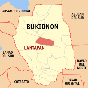
mapsize =
map_caption = Map ofBukidnon showing the location of Lantapan, Bukidnon
mapsize1 =
map_caption1 =
pushpin_
pushpin_label_position =
pushpin_map_caption =
pushpin_mapsize =
subdivision_type = Country
subdivision_name =Philippines
subdivision_type1 = Region
subdivision_name1 = Region X
subdivision_type2 = Province
subdivision_name2 = Bukidnon
subdivision_type3 = Districts
subdivision_name3 = 2nd District
subdivision_type4 =Barangays
subdivision_name4 = 14
government_type =
leader_title = Mayor
leader_name = Godofredo I. Balansag
leader_title1 = Vice Mayor
leader_name1 = Ernie R. Devibar
established_title =
established_date =
established_title2 = Incorporated (town)
established_date2 =June 18 ,1968
established_title3 =
established_date3 =
area_magnitude =
unit_pref =
area_footnotes =
area_total_km2 = 318.2
area_land_km2 =
area_water_km2 =
area_total_sq_mi = 122.86
area_land_sq_mi =
area_water_sq_mi =
area_water_percent =
area_urban_km2 =
area_urban_sq_mi =
area_metro_km2 =
area_metro_sq_mi =
population_as_of = 2000
population_footnotes =
population_note =
population_total = 42,383
population_density_km2 = 134
population_density_sq_mi = 345
population_metro =
population_density_metro_km2 =
population_density_metro_sq_mi =
population_urban =
population_density_urban_km2 =
population_density_urban_sq_mi =
timezone = PST
utc_offset = +8
timezone_DST =
utc_offset_DST =
latd= |latm= |lats= |latNS=
longd= |longm= |longs= |longEW=
elevation_footnotes =
elevation_m = 600
elevation_ft = 1, 968.5
postal_code_type = ZIP code
postal_code = 8722
area_code = 88
blank_name =
blank_info =
blank1_name =
blank1_info =
website =
footnotes =Lantapan is a 3rd class municipality in the province of Bukidnon,
Philippines . According to the 2000 census, it has a population of 42,383 people in 7,880 households.Its main
industry isagriculture . It has twobanana plantation s, the Dole Banana Plantation and the Mt. Kitanglad Agriventure, Inc. (MKAVI).History of Lantapan
Lantapan is a landlocked plateau, situated between the Kalatungan and Kitanglad ranges. Because of its location, the place was named after a native word "Lantapan" which means "level-on-top". It was formerly a barrio of Malaybalay but under Republic Act 4787, Lantapan was segregated and became a regular municipality on
June 18 ,1968 . The new municipality struggled to support its early operations with meager funds. But through strong political will and sound managements by its elected officials, it has survived difficulties and continues to face the emerging challenges of development. Today, Lantapan's various potentials continue to attract more and more visitors, migrants and investors.Geography
Land and Water
Nestled in the heart of
Bukidnon , Lantapan is bounded on the north by the municipalities of Sumilao and Impasug-ong; east byMalaybalay City ; south by Valencia City; and west by Talakag. It lies above sea level at an average of 600 meters and a maximum of 2,938 meters of the Kitanglad range. Blessed with rich agriculture and forest lands, it has an aggregate area of 318.2 km². It has six river channels and 40 creeks and springs traversing across different points in the landscape. Lantapan is strategically located between two cities ofBukidnon , Malaybalay and Valencia. It can be reached via Aglayan crossing, which is a potential convergent zone of four cities: Iligan, Butuan, Davao andCagayan de Oro . Politically, it is sub-divided into 14 barangays and 68 sitios. The central district of the Poblacion is almost midway between the north and south sections of the municipality.Climate
The climatic condition of Lantapan is relatively cool and humid with winds blowing northward direction. November to April is relatively dry and May brings the start of the rains which continue 'til October. Mountains of neighboring towns in the north protect it from cyclone storms.
The People
Originally, the Talaandig were the main inhabitants of Lantapan. Then, migrants from the Visayas and Northern Luzon started to settle in the area, even during the Spanish colonial period. More inflow took place after the Second World War. This stream of settlers eventually led to the varied mix of ethnic groups in Lantapan. Visayan is the predominant language, followed by "Binukid". 1990 Census showed Lantapan's population have reached 41,581 with Kibangay as the most populated barangay. Its population growth rate between 1980-1990 of 4.18% was well above the national rate of 2.3 percent. With this, the population is expected to double in less than twenty years. In general, Lantapanons are friendly, you feel at home with them, straight away.
ocio-Economic Profile
Education
Presently, there is a total of 24 primary, elementary and secondary schools in Lantapan. There are privately owned and one is semi-private and semi-government, while the rest are government-owned. These schools serve approximately 7,000 children. Day care centers under the Department of Social Welfare and Development provide preparatory education to pre-schoolers in the barangays.
Agriculture
Lantapan has agri-based economy. Farming has remained a dominant economic activity among the Lantapanons. The major crops grown are corn, coffee, cabbage and potatoes. Sugarcane also becoming an important commercial crop.
Commerce
There are 428 commercial establishments registered at the Licensing Division of the municipality, 15 of which are classified under agro-industrial, manufacturing and servicing. Trading activities include wholesale buying of corn, coffee and vegetables by traders from within Lantapan, neighboring towns in Bukidnon and Cagayan de Oro City.
Finance
For finance, the informal credit or "suki" system prevails. In this arrangement, the trader is usually the "suki" who provides credit too and buys the products of the farmer. A few cooperatives in some barangays also extend small loans to their members. An Asian Hills Bank located at the Poblacion and established in 1978, is owned by a private corporation. Its portfolio includes agricultural, commercial and real estate loans.
Health Services
The rural health unit (RHU) maintains one central health unit and 14 barangay health stations. The RHU provides medical, dental, family planning and laboratory services. Recently, it has started to provide special care and rehabilitation to malnourished children. One privately owned clinic for urgent care on minor cases and two registered mini-pharmaceutical stores are found in the Poblacion.
Water Works
Potable water is distributed through individual installations of 3,958 households. A feasibility study is being developed for the establishments of an improved and modern water system for Lantapan which entails tapping the Kulasihan and Songco water sources for an estimated flow of 45,018.168 cubic meter per hour.
Peace and Order
Lantapan is generally peaceful. Security in the area is ably maintained by the local police force. Trained civilian forces, the "Bantay-Bayan" and the Civilian Volunteer Organization (CVO) in the barangays also provide support to crime prevention.
LGU Plans and Programs
* Agrarian Reform Community Project (ARCP) of DAR and ADB
* Made an Annual Investment Plan
* LGU - Urban Water Supply and Sanitation (LGU-UWSSP) of World Bank
* Infrastructure Projects at the Municipal and Barangay Level, 29 projects completed
* Construction of Municipal Hall Building
* Completion of Municipal GymnasiumBarangays
Lantapan is politically subdivided into 14
barangay s.* Alanib
* Baclayon
* Balila
* Bantuanon
* Basak
* Bugcaon
* Kaatuan
* Capitan Juan
* Cawayan
* Kulasihan
* Kibangay
* Poblacion
* Songco
* Victory
* BabahagonExternal links
* [http://www.nscb.gov.ph/activestats/psgc/default.asp Philippine Standard Geographic Code]
* [http://www.t-macs.com/kiso/local/ 2000 Philippine Census Information]
Wikimedia Foundation. 2010.