- Hartfield
-
Coordinates: 51°06′N 0°07′E / 51.10°N 0.11°E
Hartfield 
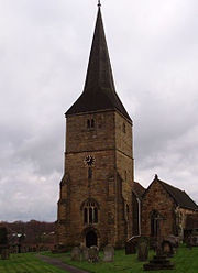
Hartfield Parish Church
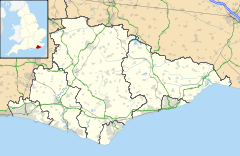
 Hartfield shown within East Sussex
Area 42.0 km2 (16.2 sq mi) [1] Population 2,157 (2007)[1] - Density 133 /sq mi (51 /km2) OS grid reference TQ479359 - London 29 miles (47 km) NNW District Wealden Shire county East Sussex Region South East Country England Sovereign state United Kingdom Post town HARTFIELD Postcode district TN7 Dialling code 01892 01342 Police Sussex Fire East Sussex Ambulance South East Coast EU Parliament South East England UK Parliament Wealden Website Parish Council List of places: UK • England • East Sussex Hartfield is a civil parish in East Sussex, England. Settlements within the parish include the village of Hartfield, Colemans Hatch, Hammerwood and Holtye, all lying on the northern edge of Ashdown Forest.
Contents
Geography
The main village of Hartfield lies seven miles (11.2 km) south-west of Tunbridge Wells on the B2026 road between Groombridge and Maresfield.
Governance
Hartfield Parish Council[2] consists of 13 members.
The parish settlements
Hartfield
Hartfield is the main village in the parish. The church is dedicated to St Mary the Virgin. There are three public houses: Anchor Inn; Gallipot Inn; and Haywagon Inn. The village street is narrow, precluding much parking although The Anchor and Haywagon Inns have private car parks for patrons only.
Cotchford Farm, Hartfield was the home of A.A. Milne (1882–1956), author of the Winnie the Pooh books, from where many of his books are set; later it was owned by Brian Jones the guitarist and founder of The Rolling Stones who was discovered dead in the pool in 1969. There is a shop in the village dedicated to all things connected with the Winnie the Pooh stories.[3]
Henry VIII was believed to have used Bolebroke Castle, located a short distance from the village, where he hunted wild boar and deer at the nearby Ashdown Forest. He also was believed to have courted Anne Boleyn from this castle.
Hartfield had a railway station on the Three Bridges to Tunbridge Wells Central Line until it was closed in 1967. Most of the former trackbed is now part of the Forest Way, forms part of National Cycle Route 21, and is much used by walkers and cyclists. The station building itself is now used as a pre-school. There is a bus service that connects the village with Crawley, East Grinstead and Tunbridge Wells.
There are a number of businesses in the village.[4]
Colemans Hatch
The hamlet of Colemans Hatch lies to the south-west of Hartfield. It is a scattered settlement around a series of road junctions. The church here is dedicated to the Holy Trinity and is part of the joint benefice with St Mary’s Hartfield.[5] The Hatch Inn is located here.
General Sir Reginald Hildyard (1876–1965) lived at South Hartfield House, Colemans Hatch.
Hammerwood
The name Hammerwood comes from the Wealden iron industry and relates to the numerous hammer-ponds found in the area. Streams in the locality can still run red with the colour of iron in the water. A hammer-pond is a water reservoir created specifically for providing power to water-powered hammers, forges or blast furnaces. There were many Medway watermills in the area.
Aside from a number of houses, the most notable buildings are St Stephen's Church[6] and Hammerwood Park at the end of the lane, which was the centre of what was a large country estate extending in its heyday to over 2,500 acres (10 km²).
The church was completed in 1880 funded by local landowner Oswald Augustus Smith and built to a design of E.P. Loftus Brock. Smith also funded the rebuilding of St Peter's Church in Holtye within the same parish. The church can be found on the main road. Inside the church is a pipe organ built by T.C. Lewis of Brixton in 1884.
There is a Scout campsite at Hammerwood owned and operated by the Lewisham North District Scouts.[7]
Hammerwood Park
Hammerwood Park[8] is a country house south of the village: it is Grade I listed of historical interest. Built in 1792, it was the first work of the architect Benjamin Latrobe, who was also responsible for the United States Capitol in Washington, D.C. It was one of the first houses in England built in the Greek Revival style. It was bought by the rock band Led Zeppelin in 1973, although not properly maintained by them. Left almost derelict, it was then bought in 1982 and restoration began: that restoration was award-winning and it received a lot of television coverage. The house is often used for filming, and is open to the public in the summer: concerts are often held there.[9]
Holtye
Holtye is immediately north-east of Hammerwood. Here the public house is The White Horse Inn; the church is dedicated to St Peter,[10] although the church is now redundant.
Marsh Green
Marsh Green is a group of buildings near Colemans Hatch. The region has been mentioned in census records since 1841. Marsh Green is close to the Poohsticks Bridge, and visitors missing the turning can find themselves there.[11]
Economy
MK Airlines has its head office in Hatfield.[12]
Landmarks
Ashdown Forest falls partly within the parish. This Site of Special Scientific Interest is a large area of common ground comprising area of semi-natural woodland, heath and bog.[13]
Demography
In the 2001 census return, there were 2,105 people in the parish. Age breakdown is approximately as follows: 0-15: 28%; 16-59: 49%; 60+ : 23%. There were 1,640 registered voters in 1998. The average values of houses in 2001 for Hartfield parish for all property types was £286,736.[14]
References
- ^ a b "East Sussex in Figures". East Sussex County Council. http://www.eastsussexinfigures.org.uk/webview/. Retrieved 2008-04-26.
- ^ Hartfield Online: parish council website
- ^ Shop at Pooh Corner
- ^ List of businesses in Hartfield
- ^ Holy Trinity Church Colemans Hatch
- ^ St Stephen's Church
- ^ http://hammerwood.org.uk
- ^ Hammerwood Park official website
- ^ Recordings of concerts at Hammerwood Park
- ^ St Peter's Church Holtye
- ^ Map of Marsh Green in 1875
- ^ "Get in touch with MK today..." MK Airlines. Retrieved on 9 September 2010.
- ^ "Natural England - SSSI (Ashdown Forest)". English Nature. http://www.english-nature.org.uk/special/sssi/sssi_details.cfm?sssi_id=1001983. Retrieved 2008-09-27.
- ^ About Hartfield
External links
 Media related to Hartfield at Wikimedia Commons
Towns, villages and hamlets in the Wealden District of East Sussex, England Alciston • Alfriston • Arlington • Berwick • Best Beech Hill • Birling Gap • Blackboys • Blackham • Bodle Street Green • Boreham Street • Broad Oak • Burlow • Buxted • Chalvington • Chelwood Gate • Chiddingly • Coleman's Hatch • Cooper's Green • Cowbeech • Cross in Hand • Crowborough • Danehill • Duddleswell • East Dean • East Hoathly • Eridge Green • Etchingwood • Exceat • Fairwarp • Five Ash Down • Five Ashes • Fletching • Folkington • Forest Row • Framfield • Frant • Friston • Furner's Green • Golden Cross • Groombridge • Gun Hill • Hadlow Down • Hailsham • Halland • Hammerwood • Hankham • Hartfield • Heathfield • Hellingly • Heron's Ghyll • Herstmonceux • High Hurstwood • Holtye • Hooe • Hooe Common • Horam • Horney Common • Isfield • Jevington • Laughton • Litlington • Little Horsted • Little London • Lower Dicker • Lower Horsebridge • Lullington • Magham Down • Maresfield • Mark Cross • Mayfield • Maynard's Green • Milton Street • Muddles Green • Ninfield • Nutley • Old Heathfield • Pevensey • Pevensey Bay • Polegate • Poundgate • Punnett's Town • Rickney • Ripe • Roser's Cross • Rotherfield • Rushlake Green • Selmeston • Stone Cross • Stunts Green • Tidebrook • Three Cups Corner • Uckfield • Upper Dicker • Upper Hartfield • Vines Cross • Wadhurst • Waldron • Warbleton • Wartling • Westdean • Westham • Whitesmith • Willingdon • Wilmington • Windmill Hill • Winton • Withyham • Wych CrossCategories:- Wealden
- Local government in East Sussex
- Villages in East Sussex
- Houses in East Sussex
- Greek Revival buildings
Wikimedia Foundation. 2010.


