- Heathfield, East Sussex
-
Coordinates: 50°58′N 0°16′E / 50.97°N 0.26°E
Heathfield 
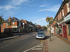
Heathfield High Street
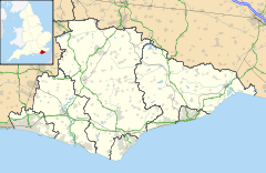
 Heathfield shown within East Sussex
OS grid reference TQ586209 - London 40 miles (64 km) NNW Parish Heathfield and Waldron District Wealden Shire county East Sussex Region South East Country England Sovereign state United Kingdom Post town HEATHFIELD Postcode district TN21 Dialling code 01435 Police Sussex Fire East Sussex Ambulance South East Coast EU Parliament South East England UK Parliament Wealden Website http://www.heathfield.net/ List of places: UK • England • East Sussex Heathfield is a small market town, and the principal settlement in the civil parish of Heathfield and Waldron in the Wealden District of East Sussex, within the historic County of Sussex, England.
Contents
Location
Heathfield lies near the junction of two main roads: the A267 between Tunbridge Wells and Eastbourne; and the A265 from Hawkhurst. It lies almost equidistant from Tunbridge Wells and Eastbourne: approximately sixteen miles (26 km).
History
Historically, Heathfield lay on an ancient trackway (The Ridgeway), connecting the South Downs with the Weald. Its market charter was granted in February 1316 during the reign of Edward II. The Wealden iron brought prosperity to the town during the 16th/17th centuries; the coming of the railway (the Cuckoo Line) in 1880 gave it another new lease of life. The latter was not a financial success and the branch line between Eridge and Polegate closed in 1968. The trackbed is now named the Cuckoo Trail, part of the National Cycle Network.
The original village —Old Heathfield— is now only part of the town, which has expanded over time.
Crime
The crime rates in Heathfield were lower than the national average:[1]
Crime rates in Heathfield (per 1000 population) 2005-2006 Offence Locally Nationally Robbery 0.25 1.85 Theft of a motor vehicle 1.87 4.04 Theft from a motor vehicle 5.35 9.59 Sexual offences 0.52 1.17 Violence against a person 10.14 19.97 Burglary 2.82 5.67 Landmarks
The parish church in Heathfield is dedicated to All Saints: an example of a Harmer terracotta decorated gravestone is in the churchyard. The town is the home of Heathfield Park Cricket Club, formed in 1878, and enjoying one of the most scenic positions of any cricket ground in Sussex.
The nearby mansion of Heathfield Park dates from the seventeenth century. In a corner of the estate stands a memorial named the Gibraltar Tower. To the north-east, on the edge of the parish, Braylsham Castle is a modern house begun in 1993, built in imitation of a moated medieval manor house, complete with working drawbridge.
Approximately one mile from the town is the Heathfield transmitting station, a 135 m high mast which broadcasts TV and radio signals to East and West Sussex, as well as parts of south Kent.
Culture
The town holds an annual fair named the Heffle Cuckoo Fair each April, the annual Heathfield show takes place each May and a carnival happens in the summer. Heathfield is the home of Heathfield Community College and several primary schools. Opposite the college is a leisure centre. There is also a French market held every year on the August Bank Holiday and a fair that comes to visit during the Summer for about 5 days. There is a fairly large football field, beside it a little playground. At Cross-in-Hand there is a rugby club for adults and children.
There is a small youth centre next door to the Co-op Supermarket. Within the town there are two florists, several churches, a couple of hair and beauty salons, 2 boutiques, an electrical shop, two bookshops, 2 ironmongers, five charity shops, two pubs, a green grocer, a butcher, a baker, two antique shops, a Budgens Supermarket and a Tesco Express, and a number of banks, estate agents, take-aways and restaurants. A large retirement home has recently been built, as well as several blocks of flats and new houses.
There is a bus service which is expensive and not very frequent.
Heathfield Detachment - Sussex ACF
Heathfield has an Army Cadet Force (ACF) Detachment) which is part of the Sussex ACF group. This detachment is based in the Youth Centre on the High street, and is affiliated to PWRR.[2] The Detachment meets on Monday and Wednesday evenings from 19:30 to 21:30 each week.[2]
Heathfield Silver Band
The Heathfield Silver Band is a silver band headquartered in Heathfield with a history dating back as far as 1880. The band has a large membership, with members spanning the ages of 9 to 80. Although women were not allowed to participate in years past, the band now accepts members regardless of gender.
The rehearsal site on Alexandra Road in Heathfield was extended and refurbished following a steady increase in band membership. TV presenter David Dimbleby officially opened the newly extended band room on 3 September 2005.
The Heathfield Silver Band plays at weddings, garden parties, church functions, and fetes and regularly gives concerts. They are also a marching band, taking part in the local bonfire celebrations. During September they march in Uckfield, Crowborough, Mayfield, Lewes, and East Hoathly carnivals, as well as marching on Remembrance Sunday, St. George's Day, and Heathfield's Heffle Cuckoo Fair.
Notable people
Famous residents include Tom Baker and Jayne Torvill.
See also
- List of places of worship in Wealden
References
- ^ Heathfield Crime Figures at Findanewhome.com
- ^ a b "Heathfield ACF Home". http://www.sussexacf.co.uk/location_heathfield.htm. Retrieved 2008-07-03.
External links
- A page about George Augustus Eliott (Baron Heathfield)
- Heathfield, East Sussex at the Open Directory Project
- Heathfield and Waldron Parish Council
- All Saints church
- Heathfield Silver Band
- Heathfield information website about local events and services
- Heathfield Youth Centre
- Running club for Heathfield
Towns, villages and hamlets in the Wealden District of East Sussex, England Alciston • Alfriston • Arlington • Berwick • Best Beech Hill • Birling Gap • Blackboys • Blackham • Bodle Street Green • Boreham Street • Broad Oak • Burlow • Buxted • Chalvington • Chelwood Gate • Chiddingly • Coleman's Hatch • Cooper's Green • Cowbeech • Cross in Hand • Crowborough • Danehill • Duddleswell • East Dean • East Hoathly • Eridge Green • Etchingwood • Exceat • Fairwarp • Five Ash Down • Five Ashes • Fletching • Folkington • Forest Row • Framfield • Frant • Friston • Furner's Green • Golden Cross • Groombridge • Gun Hill • Hadlow Down • Hailsham • Halland • Hammerwood • Hankham • Hartfield • Heathfield • Hellingly • Heron's Ghyll • Herstmonceux • High Hurstwood • Holtye • Hooe • Hooe Common • Horam • Horney Common • Isfield • Jevington • Laughton • Litlington • Little Horsted • Little London • Lower Dicker • Lower Horsebridge • Lullington • Magham Down • Maresfield • Mark Cross • Mayfield • Maynard's Green • Milton Street • Muddles Green • Ninfield • Nutley • Old Heathfield • Pevensey • Pevensey Bay • Polegate • Poundgate • Punnett's Town • Rickney • Ripe • Roser's Cross • Rotherfield • Rushlake Green • Selmeston • Stone Cross • Stunts Green • Tidebrook • Three Cups Corner • Uckfield • Upper Dicker • Upper Hartfield • Vines Cross • Wadhurst • Waldron • Warbleton • Wartling • Westdean • Westham • Whitesmith • Willingdon • Wilmington • Windmill Hill • Winton • Withyham • Wych CrossCategories:- Wealden
- Market towns in East Sussex
- Towns in East Sussex
Wikimedia Foundation. 2010.


