- Crowhurst, East Sussex
-
Coordinates: 50°53′N 0°30′E / 50.89°N 0.50°E
Crowhurst
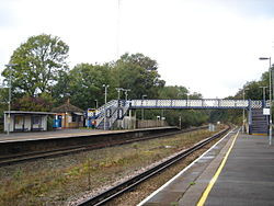
Crowhurst railway station
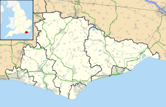
 Crowhurst shown within East Sussex
Area 10.1 km2 (3.9 sq mi) [1] Population 859 (Parish-2007)[1] - Density 219 /sq mi (85 /km2) OS grid reference TQ755125 - London 50 miles (80 km) NNW District Rother Shire county East Sussex Region South East Country England Sovereign state United Kingdom Post town BATTLE Postcode district TN33 Dialling code 01424 Police Sussex Fire East Sussex Ambulance South East Coast EU Parliament South East England UK Parliament Bexhill and Battle Website Crowhurst Village List of places: UK • England • East Sussex Crowhurst is an isolated village situated five miles (8 km) north-west of Hastings in East Sussex. It has a parish council and is located within the Rother District Council.
Contents
History
The earliest mention of the settlement is in 771, when King Offa of Mercia gave the Bishop of Selsey a piece of land here; a church was then built by the Bishop. Crowhurst (then called Croghyrst) itself remained the king's land until 1412, although various landowners were given possession of it over that time:
- Robert Count of Eu, after the Norman Conquest of England
- the Fitz-Lambert family, until the 12th century
- Walter de Scotney, given by Richard I after the Third Crusade, although Walter forfeited it in 1259, having been found guilty of a crime
- Sir John Pelham, given to him by Henry IV in 1412; Pelham built the present parish church
Governance
At a local level, Crowhurst is governed by a parish council which is responsible for street lighting, allotments and recreational areas. It provides a local voice to the district and county councils. The parish council consists of seven councillors. The May 2007 election had ten candidates standing.[2]
Rother District council provides the next level of government with services such as refuse collection, planning consent, leisure amenities and council tax collection. Crowhurst is within the Crowhurst ward, along with the parishes of Ashburnham and Penhurst, Catsfield and part of Battle. In the May 2007 election Crowhurst ward was won by the Conservative candidate.[3]
East Sussex county council is the third tier of government, providing education, libraries and highway maintenance. Crowhurst falls within the Battle and Crowhurst ward. Kathryn Margaret Field, Liberal Democrat, was elected in the May 2005 election with 48.8% of the vote.[4]
The UK Parliament constituency for Crowhurst is Bexhill and Battle. Gregory Barker was re-elected in the May 2010 election.
At European level, Crowhurst is represented by the South-East region, which holds ten seats in the European Parliament. The June 2004 election returned four Conservatives, two Liberal Democrats, two UK Independence, one Labour and one Green, none of whom live in East Sussex.[5]
The village
The parish church is dedicated to St George.[6] The ruins of the manor house lie to the south of it.
Although small, the village does have a railway station. It was built in 1902 as a junction station for a branch line to Bexhill. The line crossed nearby marshes on a 17-arch viaduct; the line was closed under the so-called "Beeching cuts" in 1964, and the viaduct was demolished in 1969.
The village has a primary school.[7] The village post office closed in March 2008: until then it served as a convenience store also.[8] There is a pub, The Plough; until 1998 there was a second pub, The Inn at Crowhurst.[9]
Crowhurst is the home of musician Oliver Frost, guitarist in the alternative band Mumm-Ra. It was at the Crowhurst village hall that the band put on the now legendary industry showcase in August 2005 that saw them gain a major label deal with Columbia Records.
Landmarks
The village is home to the Fore Wood RSPB reserve, part of which is a Site of Special Scientific Interest (SSSI). The interest is due to its ghyll habitat; steep ravines cut into the underlying sandstone.[10] The site is a rich breeding area for birds.
Like the village of the same name in Surrey, this East Sussex Crowhurst also has an ancient yew tree in the church grounds cordoned off by iron railings and reinforced with steel wires to prevent collapse. Age uncertain.
Another SSSI within the parish is Combe Haven. This site is of biological importance due to its diversity of habitat supporting many species of flora and fauna. Alluvial meadows and reed beds cover a large section of the area.[11]
References
- ^ a b "East Sussex in Figures". East Sussex County Council. http://www.eastsussexinfigures.org.uk/webview/. Retrieved 2008-04-26.
- ^ "Declaration of Result of Poll—Crowhurst parish". Rother District Council. 5 May 2005. http://www.rother.gov.uk/index.cfm?articleid=2864. Retrieved 29 November 2008.
- ^ "Declaration of Result of Poll—Crowhurst". Rother District Council. 5 May 2005. http://www.rother.gov.uk/index.cfm?articleid=2857. Retrieved 24 November 2008.
- ^ "County Council election". Rother District Council. 5 May 2005. http://www.eastsussex.gov.uk/yourcouncil/localelections/electionmap/results.aspx#battlecrowhurst. Retrieved 19 November 2008.
- ^ "UK MEP's". UK Office of the European Parliament. Archived from the original on 24 January 2007. http://web.archive.org/web/20070124233126/http://www.europarl.org.uk/uk_meps/MembersMain.htm. Retrieved 25 January 2007.
- ^ The parish church photographs
- ^ Crowhurst Primary School
- ^ Closure of post office
- ^ Crowhurst, East Sussex at the Open Directory Project further village information
- ^ "Natural England - SSSI (Fore Wood)". English Nature. http://www.english-nature.org.uk/special/sssi/sssi_details.cfm?sssi_id=1001983. Retrieved 2008-09-27.
- ^ "Natural England - SSSI (Combe Haven)". English Nature. http://www.english-nature.org.uk/special/sssi/sssi_details.cfm?sssi_id=1001853. Retrieved 2008-10-03.
External links
 Media related to Crowhurst, East Sussex at Wikimedia Commons
Towns Villages and hamlets Ashburnham • Ashburnham Forge • Beckley • Bodiam • Bowler's Town • Brede • Brightling • Brownbread Street • Burwash • Cackle Street • Camber • Catsfield • Cliff End • Cripps Corner • Crowhurst • Dallington • East Guldeford • Etchingham • Ewhurst Green • Fairlight • Fairlight Cove • Flimwell • Guestling Green • Guestling Thorn • Hollingrove • Houghton Green • Hurst Green • Icklesham • Iden • Mountfield • Northbridge Street • Northiam • Oxley's Green • Peasmarsh • Penhurst • Pett • Pett Level • Playden • Ponts Green • Robertsbridge • Rye Foreign • Rye Harbour • Salehurst • Saltcote • Saltcote Street • Sedlescombe • Silver Hill • Springfield • Staplecross • Stonegate • Ticehurst • Three Oaks • Twelve Oaks • Udimore • Westfield • Whatlington • Winchelsea • Winchelsea Beach •Civil parishes Ceremonial county of East Sussex East Sussex Portal Unitary authorities Boroughs or districts Major settlements Battle · Bexhill-on-Sea · Brighton · Crowborough · Eastbourne · Hailsham · Hastings · Heathfield · Hove · Lewes · Newhaven · Peacehaven · Polegate · Rye · Seaford · Telscombe · Uckfield · Wadhurst
See also: List of civil parishes in East SussexRivers Topics History · Geography · Museums · Parliamentary constituencies · Places · Transport · South Downs · North Downs · Beachy Head · High Weald · Long Man of WilmingtonCategories:- Rother
- Local government in East Sussex
- Villages in East Sussex
Wikimedia Foundation. 2010.


