- Dallington, East Sussex
-
Coordinates: 50°56′50″N 0°21′28″E / 50.947116°N 0.357868°E
Dallington
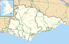
 Dallington shown within East Sussex
Area 7.9 km2 (3.1 sq mi) [1] Population 310 (Parish-2007)[1] - Density 102 /sq mi (39 /km2) OS grid reference TQ657190 - London 43 miles (69 km) NNW District Rother Shire county East Sussex Region South East Country England Sovereign state United Kingdom Post town HEATHFIELD Postcode district TN21 Dialling code 01435 Police Sussex Fire East Sussex Ambulance South East Coast EU Parliament South East England UK Parliament Bexhill and Battle Website http://www.dallington.net/ List of places: UK • England • East Sussex Dallington is a village and civil parish in the Rother District of East Sussex, England. It is located eight miles (13 km) west of Battle and five miles (8 km) east of Hailsham.
Governance
The lowest level of government is the Dallington parish council. The parish council is responsible for local amenities such as the provision of litter bins, bus shelters and allotments. They also provide a voice into the district council meetings. The parish council comprises five councillors with elections being held every four years.
Rother District council provides the next level of government with services such as refuse collection, planning consent, leisure amenities and council tax collection. Dallington lies within the Darwell ward, which provides two councillors. The May 2007 election returned one Conservative and one independent councillor.
East Sussex county council is the third tier of government, providing education, libraries and highway maintenance. Brightling falls within the Rother North West ward. Anthony (John) Barnes, Conservative, was elected in the May 2005 election with 56.3% of the vote.
The UK Parliament constituency for Dallington is Bexhill and Battle. Gregory Barker was re-elected in the May 2005 election.
At European level, Dallington is represented by the South-East region, which holds ten seats in the European Parliament. The June 2004 election returned four Conservatives, two Liberal Democrats, two UK Independence, one Labour and one Green, none of whom live in East Sussex.[2]
References
- ^ a b "East Sussex in Figures". East Sussex County Council. http://www.eastsussexinfigures.org.uk/webview/. Retrieved 2008-04-26.
- ^ "UK MEP's". UK Office of the European Parliament. Archived from the original on 2007-01-24. http://web.archive.org/web/20070124233126/http://www.europarl.org.uk/uk_meps/MembersMain.htm. Retrieved 2007-01-25.
External links
 Media related to Dallington, East Sussex at Wikimedia Commons
Towns Villages and hamlets Ashburnham • Ashburnham Forge • Beckley • Bodiam • Bowler's Town • Brede • Brightling • Brownbread Street • Burwash • Cackle Street • Camber • Catsfield • Cliff End • Cripps Corner • Crowhurst • Dallington • East Guldeford • Etchingham • Ewhurst Green • Fairlight • Fairlight Cove • Flimwell • Guestling Green • Guestling Thorn • Hollingrove • Houghton Green • Hurst Green • Icklesham • Iden • Mountfield • Northbridge Street • Northiam • Oxley's Green • Peasmarsh • Penhurst • Pett • Pett Level • Playden • Ponts Green • Robertsbridge • Rye Foreign • Rye Harbour • Salehurst • Saltcote • Saltcote Street • Sedlescombe • Silver Hill • Springfield • Staplecross • Stonegate • Ticehurst • Three Oaks • Twelve Oaks • Udimore • Westfield • Whatlington • Winchelsea • Winchelsea Beach •Civil parishes Ceremonial county of East Sussex East Sussex Portal Unitary authorities Boroughs or districts Major settlements Battle · Bexhill-on-Sea · Brighton · Crowborough · Eastbourne · Hailsham · Hastings · Heathfield · Hove · Lewes · Newhaven · Peacehaven · Polegate · Rye · Seaford · Telscombe · Uckfield · Wadhurst
See also: List of civil parishes in East SussexRivers Topics History · Geography · Museums · Parliamentary constituencies · Places · Transport · South Downs · North Downs · Beachy Head · High Weald · Long Man of WilmingtonCategories:- Rother
- Local government in East Sussex
- Villages in East Sussex
- East Sussex geography stubs
Wikimedia Foundation. 2010.

