- Uckfield
-
Coordinates: 50°58′N 0°06′E / 50.97°N 0.10°E
Uckfield 
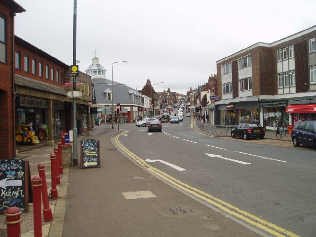
Uckfield town centre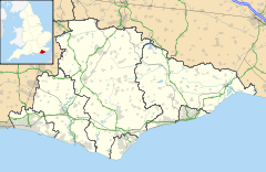
 Uckfield
Uckfield shown within East SussexArea 7.5 km2 (2.9 sq mi) [1] Population 13,873 (2007) [1] - Density 4,810 /sq mi (1,860 /km2) OS grid reference TQ473212 - London 38 miles (61 km) NNW District Wealden Shire county East Sussex Region South East Country England Sovereign state United Kingdom Post town UCKFIELD Postcode district TN22 Dialling code 01825 Police Sussex Fire East Sussex Ambulance South East Coast EU Parliament South East England UK Parliament Wealden Website http://www.uckfield.co.uk/ List of places: UK • England • East Sussex Uckfield is a town in the Wealden district of East Sussex, in southern England. It is located on the southern edge of the Weald and on the River Uck, one of the tributaries of the River Ouse.
Contents
Etymology
The town was originally called Uccafield.[2] Uccafield derives from the Celtic word for 'High' or 'Height' - Uchafedd, this in turn coming from the Indo European 'Uchch'ya'. When the Anglo Saxons heard this word they changed the 'fedd' part to something they understood - 'Feld' from which 'field' derives. The original river Uck name was most likely related to the ancient Celtic word for 'water' or 'stream' - Uisge, derivations uske, usci, that give river names still existing such as the Usk. When the Celts came along the sound of the river name was so close to the sound of Ucha that the name became Uch or Ucca over time and eventually Uck. So Uckfield really means something like 'high place' - Uchafedd - and the river derived its modern name from this Celtic word. There are, however, other theories as to how the name came about. One theory suggests that it came from "Oak in Field", something which is reflected in several town crests. Another theory is that it used to be the free land of a Saxon man called Ucca.
History
- A comprehensive historical timeline can be found at The Weald of Kent, Surrey and Sussex website.[3]
The first mention in historical documents is in the late thirteenth century. Uckfield developed as a stopping-off point on the pilgrimage route between Canterbury, Chichester and Lewes. The settlement began to develop around the bridging point of the river, including the locally-famous Pudding Cake Lane where travellers visited a public house for slices of pudding cake; and the 15th-century Bridge Cottage, the oldest house still standing in Uckfield, now a museum. The town developed in the High Street and in the New Town areas (the latter to the south of the original town centre).
The Eversfield family, who later became prominent in Sussex history, giving their name to the prime waterfront street of St Leonards-on-Sea, first settled in Uckfield from their Surrey beginnings.[4] The family, who later owned the mansion Denne Park in Horsham, which they represented in Parliament, acquired a large fortune through marriage, real estate acquisition and iron foundering.[5] Their climb to wealth and prominence was a heady one: in fifteenth-century Sussex they were described as 'yeomen', but within a generation they were already among the first rank of Sussex gentry.[6] The saxon word for oak was "uck" So they named it uckfield, Which in english would be oakfield, but it keeps its saxon name.
Church Street Uckfield
As its name indicates, Church Street was at the heart of the original settlement of Uckfield, near the medieval chapel (built c.1291), which was replaced by the present parish church in 1839. Situated on an ancient ridgeway route from the direction of Winchester in the west to Rye and Canterbury in the east, it would have seen many travellers (in the traditional sense) well before 1500. Some would have been on short journeys, either on foot or on horseback, to or from local markets and fairs, but others, bound for destinations further afield, would have spent the night at local hostelries along their route such as the Maiden's Head, the King's Head (now the Cinque Ports) or the Spread Eagle. Since Uckfield was part of the Archbishop's extensive Manor of South Malling, some of these travellers could have been bound for Canterbury for business or other (e.g. religious) reasons, though others had destinations elsewhere along the route.
Church Street contains a number of post-medieval buildings. These include the Old Grammar School, Bakers Cottage and the Malt House with Malt Cottage (all built before 1700), and Church House with Andertons, Coppinghall and Milton Cottage (all 18th century). Notable inhabitants of these properties were the Markwicks (builders and carpenters, from 1700) at Coppinghall and Milton Cottage (Interestingly, the current generation of notable Markwicks in Uckfield run the local picture house), Edward Kenward (19th century maltster) at the Malt House, Thomas Pentecost (a Victorian leather cutter and local poet) in a cottage near the Grammar School and General Sir George Calvert Clarke (commander of the Royal Scots Greys at Balaclava) at Church House.
Governance
The town council consists of 15 councillors, representing four wards: Central ward (3 councillors); New Town (3); North (6); and Ridgewood (3) mayoral elections take place every year.[7]
Geography
The town of Uckfield[8] has grown up as a road hub, and on the crossing point of the River Uck. Traffic on the A26 between Tunbridge Wells and Lewes, from the north-east to the south-west, joins with that on the A22 London - Eastbourne road around the town on its bypass; whilst the long-distance cross-country A272 road (the old pilgrimage route) crosses them both north of the town.
As the town has grown, new housing estates were developed: Hempstead Fields, Harlands Farm, Rocks Park, West Park, Manor Park and Ringles Cross among them.
Parts of Uckfield, owing to its location on the river, have been subject to extensive flooding on a number of occasions, the earliest recorded being in 1800.[9] More recent floods have occurred approximately every nine years: in 1962, 1974, 1989, 1994, 2000 and 2007, although those in 2007 were not as severe as previous floods.[10] Local residents have long been lobbying for flood defences in the town, and recently when the local Somerfield became a Co-op, its car park's walls were rebuilt as flood defenses with a ramp to access the car park and a watertight pedestrian gate that can be closed when flooding is imminent. It is hoped that this new wall will act as a reservoir to contain the flood water until it recedes, allowing the water to flow back into the river Uck, which runs alongside the carpark.[11] Due to the positioning of the river within Uckfield, any flooding is within the lowest part of the town centre and industrial estate, and so does not effect residential areas as these are all built on higher ground.
The West Park Nature Reserve contains a wide variety of habitats; it is located on the western edge of the town.[12]
Neighbouring areas 
Fletching Maresfield Crowborough Burgess Hill, Haywards Heath 
Heathfield  Uckfield

Lewes Seaford Hailsham, Eastbourne Development
The local Tesco has proposed the redevelopment of the central town area as has the town council. The Hub has recently been completed, having been acquired for an unknown figure, presumed to be about half a million pounds. A complaint from citizens was the purchase cost, that it would increase their tax bills and as a youth centre it would only benefit the town's youth however many residents have noted its far reaching benefits, such as crime prevention[citation needed].
Demography
The population of Uckfield in 1811 was 916; in 1841 was 1,534; in 1861 was 1,740; in 1871 was 2,041; in 1881 was 2,146; in 1891 was 2,497; in 1901 was 2,895; in 1911 was 3,344; in 1921 was 3,385; and in 1931 was 3,555. In 2001 it was 13,697.[citation needed].
Transport
Main article: Uckfield railway stationUckfield is connected to London Bridge station by Southern rail services on its Oxted Line via East Croydon. Until 1969 the rail link continued to Lewes; after it was closed Uckfield became the terminus; the station building was rebuilt in 1991 to avoid the necessity of a level crossing. The Wealden Line Campaign hopes to reopen the closed section to Lewes.
There is a total of 20 local bus services in the Uckfield area;Brighton And Hove, Countryliner, Renown Coaches and Stagecoach in Eastbourne all serve Uckfield. Also National Express coaches operate to London.[13][14]
Education
Uckfield Community Technology College is the secondary school in the town. There are five primary schools: Manor School with nearly 400 pupils on roll in 14 classes. There is also Harlands Primary School, Holy Cross CE Primary School;[15] Rocks Park Primary School;[16] and St Philips Catholic Primary School.[17]
Churches and chapels
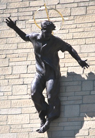
Main article: List of places of worship in Wealden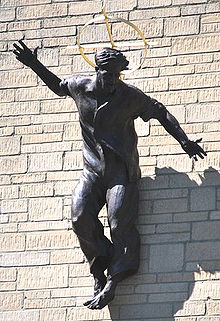 Statue of Jesus Christ by Marcus Cornish, Our Lady Immaculate and St Philip Neri church, dubbed "Jesus in Jeans" by the media
The Church of England parish church is dedicated to the Holy Cross. The Roman Catholic church is dedicated to Our Lady Immaculate and St Philip Neri. Other churches and chapels include Baptist, Methodist, Evangelical (Grange Evangelical Church in Hempstead Road)., United Reformed Church and the King's Church. Local villages and parishes also have their own sites of worship. There are no non-Christian religious houses.
Notable people
Emma Lee French was born in Uckfield in 1836. Uckfield was the last place Lord Lucan was seen, at Grants Hill House, the home of his friends Ian and Susan Maxwell-Scott.By coincidence Lady Lucan was born in Uckfield. Nicholas van Hoogstraten, the property developer, owns property in the area. He is engaged in a long-running dispute with the Ramblers' Association about a local footpath running through his land. Van Hoogstraten is currently building a mansion, Hamilton Palace, on the outskirts of Uckfield.
Mysteries
There are a number of mysteries and myths associated with the town and surrounding areas. The disappearance of Lord Lucan is one. In addition, the hoax of the Piltdown Man occurred in the nearby village of Piltdown. There is also the tale of Nan Tuck's Ghost, in which an old witch is said to have lived in a wood in nearby Buxted. There is an area of the wood where nothing grows, and the ghost is said to chase people who wander along Nan Tuck's Lane at night.[18][19][20]
Culture
Uckfield is twinned with the town of Quickborn, Germany.
The Picture House is the town's cinema, opened originally in 1915, and refurbished twice since then, the latest reopening being in February 2000.[21]
Uckfield FM is a Community Radio station that supported Uckfield for its four-week festival in June and at Christmas each year. In July 2009 was granted a licence by OFCOM to become a full time Community Radio Station, broadcasting live to the Community of Uckfield and the surrounding areas full time from 1 July 2010.[22] The station was founded by Mike Skinner, Paddy Rea, Gary King and Alan French and now has over 80 members who are all voluntary. In the summer of 2008, ITVs Trinny and Suzannah was filmed at the Bird in Eye studios when Mayor Louise Eastwood was the star of the show.
Nature Reserves
- West Park Local Nature Reserve[23]
West Park Local Nature Reserve is situated with several access points, has a board-walk running through parts of the Reserve. The Reserve is a vestige of ancient parkland, containing herb rich uncultivated wet meadow, woodland, some thriving wildlife and the remains of Mesolithic settlement.
- Hempstead Meadows Local Nature Reserve[24]
The River Uck runs through the flood plain, also occupied by the Hempstead Nature Reserve, and is an important area of wetland. The area has an abundance of unusual flora and fauna, which flourish on this ideal site.
A new footpath, the River walk is a recent introduction to this popular area.
- Harlands Pond
Harlands Pond, located via Mallard drive, home of the common toad. Regular visitors include the Heron, in addition to its permanent residents, the coot and moorhen.[25]
- Nightingale Wood
Almost adjacent to the pond is nightingale Wood. This is a cool, shady haven, containing many different tree species and is a valuable site for early purple orchids.[26]
- Millennium Green
To the south of the town in Ridgewood the Uckfield Millennium Green is present on a site of disused clay pits (now a SSSI)
References in literature
Uckfield has featured several times in notable literary works.
- Uckfield was the setting for the book Maximum Diner by Christopher Nye. It is an autobiographical work which tells of Nye's successful attempt to establish an American-style restaurant in a small town. The Maximum Diner, under new management, is still[update] in operation.
- Uckfield was featured in Julian Fellowes's novel Snobs, which included the fictional characters the Marquess and Marchioness of Uckfield.
- Uckfield was mentioned in the last chapter of John le Carré's The Honourable Schoolboy.
- The manic playwright Roland Maule, in the play Present Laughter by Noel Coward, is from Uckfield.
- The river Uck was mentioned in the 1990 novel Good Omens by Terry Pratchett and Neil Gaiman.
Other
A Holocaust denial group headed by the infamous Siegfried Verbeke has its postal address in Uckfield.[27]
References
- ^ a b "East Sussex in Figures". East Sussex County Council. http://www.eastsussexinfigures.org.uk/webview/. Retrieved 2008-04-26.
- ^ http://www.accidentconsult.com/articles/showarticles/accidentlocations/3/UckfieldBusinessAngels.html
- ^ Historical notes about Uckfield
- ^ A Compendious History of Sussex: Topographical, Archaeological & Anecdotical, Vol. I, Mark Antony Lower, London, 1870
- ^ Sussex Archaeological Collections Relating to the History and Antiquities, Sussex Archaeological Society, 1862
- ^ "Nicholas Eversfeld of Boxstede, yeoman, to Francis Chaloner, Gent., of lands in Maresfeld," Archive of Frere and Company, London, solicitors, East Sussex Record Office, The National Archives, nationalarchives.gov.uk
- ^ Uckfield Town Council
- ^ Website includes maps of the town
- ^ "ibid" The Weald of Kent, Surrey and Sussex"
- ^ Report on the flooding of the Ouse catchment in 2000
- ^ http://www.environment-agency.gov.uk/news/112405.aspx
- ^ West Park Local Nature Reserve
- ^ Bus and coach services
- ^ Brighton & Hove Buses
- ^ Holy Cross CE Primary School
- ^ Rocks Park Primary School website
- ^ St Philips Catholic Primary School
- ^ [1]
- ^ [2]
- ^ [3]
- ^ The Picture House, Uckfield
- ^ "Uckfield FM (Uckfield)". Ofcom. 26/8/2011. http://www.ofcom.org.uk/static/radiolicensing/Community/cr207.htm. Retrieved 29 August 2011.
- ^ http://www.eastsussex.gov.uk/leisureandtourism/countryside/walks/westpark/default.htm,
- ^ http://www.eastsussex.gov.uk/leisureandtourism/countryside/walks/hempsteadmeadows.htm
- ^ http://www.eastsussex.gov.uk/leisureandtourism/countryside/walks/harlandspond.htm
- ^ http://www.eastsussex.gov.uk/leisureandtourism/countryside/walks/nightingalewood.htm
- ^ Details of Verbeke's beliefs
External links
- Uckfield at the Open Directory Project
Ceremonial county of East Sussex Unitary authorities Boroughs or districts Major settlements Battle · Bexhill-on-Sea · Brighton · Crowborough · Eastbourne · Hailsham · Hastings · Heathfield · Hove · Lewes · Newhaven · Peacehaven · Polegate · Rye · Seaford · Telscombe · Uckfield · Wadhurst
See also: List of civil parishes in East SussexRivers Topics History · Geography · Museums · Parliamentary constituencies · Places · Transport · South Downs · North Downs · Beachy Head · High Weald · Long Man of WilmingtonTowns, villages and hamlets in the Wealden District of East Sussex, England Alciston • Alfriston • Arlington • Berwick • Best Beech Hill • Birling Gap • Blackboys • Blackham • Bodle Street Green • Boreham Street • Broad Oak • Burlow • Buxted • Chalvington • Chelwood Gate • Chiddingly • Coleman's Hatch • Cooper's Green • Cowbeech • Cross in Hand • Crowborough • Danehill • Duddleswell • East Dean • East Hoathly • Eridge Green • Etchingwood • Exceat • Fairwarp • Five Ash Down • Five Ashes • Fletching • Folkington • Forest Row • Framfield • Frant • Friston • Furner's Green • Golden Cross • Groombridge • Gun Hill • Hadlow Down • Hailsham • Halland • Hammerwood • Hankham • Hartfield • Heathfield • Hellingly • Heron's Ghyll • Herstmonceux • High Hurstwood • Holtye • Hooe • Hooe Common • Horam • Horney Common • Isfield • Jevington • Laughton • Litlington • Little Horsted • Little London • Lower Dicker • Lower Horsebridge • Lullington • Magham Down • Maresfield • Mark Cross • Mayfield • Maynard's Green • Milton Street • Muddles Green • Ninfield • Nutley • Old Heathfield • Pevensey • Pevensey Bay • Polegate • Poundgate • Punnett's Town • Rickney • Ripe • Roser's Cross • Rotherfield • Rushlake Green • Selmeston • Stone Cross • Stunts Green • Tidebrook • Three Cups Corner • Uckfield • Upper Dicker • Upper Hartfield • Vines Cross • Wadhurst • Waldron • Warbleton • Wartling • Westdean • Westham • Whitesmith • Willingdon • Wilmington • Windmill Hill • Winton • Withyham • Wych CrossCategories:- Wealden
- Local government in East Sussex
- Towns in East Sussex

Wikimedia Foundation. 2010.