- Del Gallego, Camarines Sur
-
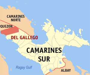
Del Gallego — Municipality — Map of Camarines Sur showing the location of Del Gallego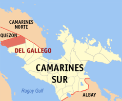 Location in the Philippines
 Del Gallego
Coordinates: 13°55′N 122°36′E / 13.917°N 122.6°ECoordinates: 13°55′N 122°36′E / 13.917°N 122.6°E Country Philippines Region Bicol Region (Region V) Province Camarines Sur District 1st district Founded Barangays 32 Government – Mayor Area – Total 286.76 km2 (110.7 sq mi) Population (2007) – Total 21,272 – Density 74.2/km2 (192.1/sq mi) Time zone PST (UTC+8) ZIP code Income class 4th class municipality; partially urban Del Gallego is a 4th class municipality in the province of Camarines Sur, Philippines. It is formerly called Danawin and located along Kilbay River. According to the 2007 census, it has a population of 21,272 people.
The municipality celebrated its 70th foundation anniversary last October 5, 2007.
Del Gallego is the last town in the northern part of Camarines Sur. This is where the Quirino Highway (Andaya Highway) road meets with the first town of Quezon province which is Tagkawayan.
According to the town's socio-economic profile in the year 1998, agricultural workers are greater in number reaching about 70% of the whole working force while the remaining 30% are engaged in non-agricultural occupations.
Contents
History
In 1959, the following sitios were converted into barrios: Sinuknipan, Sabang, Pasay and Bajo (renamed to San Juan).[1]
Barangays
Del Gallego is politically subdivided into 32 barangays.
- Bagong Silang
- Bucal
- Cabasag
- Comadaycaday
- Domagondong
- Kinalangan
- Comadogcadog
- Mabini
- Magais I
- Magais II
- Mansalaya
- Nagkalit
- Palaspas
- Pamplona
- Pasay
- Pinagdapian
- Pinugusan
- Zone I Fatima (Pob.)
- Zone II San Antonio (Pob.)
- Poblacion Zone III
- Sabang
- Salvacion
- San Juan
- San Pablo
- Santa Rita I
- Santa Rita II
- Peñafrancia (Sinagawsawan)
- Sinuknipan I
- Sinuknipan II
- Sugsugin
- Tabion
- Tomagoktok
References
- ^ "R.A. No. 2108, An Act Creating Certain Barrios in the Municipality of Del Gallego, Province of Camarines Sur". LawPH.com. http://lawph.com/statutes/ra2108.html. Retrieved 2011-04-13.
External links
- Philippine Standard Geographic Code
- 2000 Philippine Census Information
- 2007 Philippine Census Information
- Official Site of the Province of Camarines Sur
- Official Site of the Diocese of Libmanan
Municipalities Component city - Iriga
Independent component city (Administratively independent from the province, but grouped under Camarines Sur by the National Statistics Office)Categories:- Municipalities of Camarines Sur

Wikimedia Foundation. 2010.