- Milaor, Camarines Sur
-
Milaor — Municipality — Map of Camarines Sur showing the location of Milaor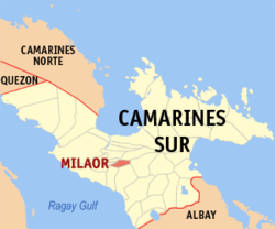 Location in the Philippines
 Milaor
Coordinates: 13°36′N 123°11′E / 13.6°N 123.183°ECoordinates: 13°36′N 123°11′E / 13.6°N 123.183°E Country Philippines Region Bicol Region (Region V) Province Camarines Sur District 2nd district(Central Bay) Founded Barangays 20 Government – Mayor Rogelio Albo Flores Area – Total 23.41 km2 (9 sq mi) Population (2007) – Total 26,452 – Density 1,129.9/km2 (2,926.5/sq mi) Time zone PST (UTC+8) ZIP code Income class 4th class municipality; partially urban Milaor is a 4th class municipality in the province of Camarines Sur, Philippines. According to the 2007 census, it has a population of 26,452 people.
Contents
History
The work of Evangelization in Milaor began in 1579 when the Franciscan missionaries came to the Philippines upon the order of Pope Sixtus V and King Philip II, and given specific assignment to work in Bicol Region. In 1585, Milaor was declared a parish under the titular patron, Saint Joseph. The first parish administrator was Fray Matias de Andrade, OFM., who arrived in Bikol in 1582 and later became the fifth Bishop of the Diocese of Nueva Caceres.
The Franciscans, Fray Juan del Sacramento and Fray Jose dela Virgen, initiated the construction of a church made of bricks and stones. This was built in a place known today as "Sinimbahanan" now a part of Cabusao, where ruins of the concrete foundation may still be found. Frequent attacks from the cimarrones and the tulisanes from nearby Mount Isarog, however, caused the transfer of the church to its present site. Fray Santiago de San Pedro de Alcantara completed the construction in 1730 and added a convent made of wooden materials in 1735. Both the church and the convent were destroyed by fire in 1740 and immediately the reconstruction was undertaken by Fray Francisco delos Santos, OFM. The present belfry was finished in 1840.
Milaor was formerly called "Milaud" or "may-laud". "Laud" means a lowland prone to being flooded, in fact that is being true up to this day. The expression "mapa-laud" means to go to a place which is low or with water, in other words, to go to a "laud". From "Milaud" or "Maylaud" it was transferred to "Milaor". The truth of this matter of the place being always filled with water is corroborated by the fact that in many barangays are to be found shells which thrive on water. These shell fossils mean that in ancient time this place was really covered with water or is frequently flooded to allow these shells or mollusks to thrive in the place.
Originally, Milaor comprised Palestina and the present parishes of Minalabac, San Fernando and Gainza. Until the eve following the uprising Naga City on September 19, 1898 during the Philippine Revolution, the Franciscan considered Milaor as their favorite resting place and abode away from the adjacent rapidly developing settlement that is Naga City today.
Parishes (Catholic Church in Milaor)
St. Joseph the Worker Parish
St. Joseph the Worker is the titular patron saint of the Municipality. The town and parish fiesta is celebrated every 1st day of May. The present parish priest is Rev. Fr. Ruben R. Buena. The vision of the parish is to continue forming Basic Ecclesial Communities, locally called as SKK or saradit na kristiyanong komunidad. The locus and focus of this dream of the Church is by clustering all the neighboring families. Each cluster is composed of 15-20 families.
St. Anthony of Padua Parish
In 1997, another parish within the municipality of Milaor was established. The seat is at barangay San Antonio and the titular patron saint is St. Anthony of Padua. At present the parish priest is Rev. Fr. Adrian G. Lasin, SOLT.
Barangays
Milaor is politically subdivided into 20 barangays.
- Alimbuyog
- Amparado (Pob)
- Balagbag
- Borongborongan
- Cabugao
- Capucnasan
- Dalipay
- Del Rosario (Pob)
- Flordeliz
- Lipot
- Mayaopayawan
- Maycatmon
- Maydaso
- San Antonio
- San Jose (Pob)
- San Miguel (Pob)
- San Roque (Pob)
- San Vicente (Pob)
- Santo Domingo (Pob)
- Tarusanan
External links
- Official site of the Diocese of Libmanan
- Philippine Standard Geographic Code
- 2000 Philippine Census Information
- 2007 Philippine Census Information
Municipalities Component city - Iriga
Independent component city (Administratively independent from the province, but grouped under Camarines Sur by the National Statistics Office)Categories:- Municipalities of Camarines Sur


Wikimedia Foundation. 2010.