- Dimiao, Bohol
-
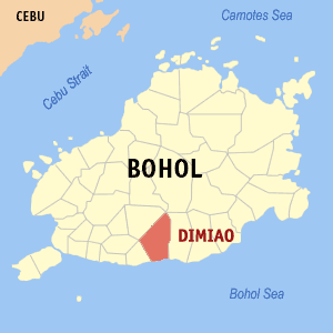
Dimiao — Municipality — Map of Bohol showing the location of Dimiao Location in the Philippines
 Dimiao
Coordinates: 9°37′N 124°10′E / 9.617°N 124.167°ECoordinates: 9°37′N 124°10′E / 9.617°N 124.167°E Country  Philippines
Region Central Visayas Province  Bohol
BoholDistrict 3rd district of Bohol Incorporated (Town) January 1, 1915 Barangays 35 Government – Mayor Sylvia B. Adame – Vice Mayor Danilo M. Guivencan – Councilors Rosa S. Caga-anan
Russel I. Yecyec
Anecita C. Ucang
Wilfredo C. Codilla
Edgardo R. Akiat
Isidro I. Jumamil
Demetria B. Ydulzura
Nerio H. Hamlag– ABC President Miguel T. Varquez – SK Chairman Gibson Noel Hamlag Area – Total 77.13 km2 (29.8 sq mi) Population (2007) – Total 14,187 – Density 183.9/km2 (476.4/sq mi) Time zone PST (UTC+8) ZIP code 6305 Income class 5th class Dimiao is a 5th class municipality in the province of Bohol, Philippines. According to the 2007 census, it has a population of 14,187 people. Dimiao is located on the southern coast of the province. How it got its name is not known. It is one of the oldest municipalities which had a population of 8,820 in 1897. This town used to occupy a large territory which included Valencia and Lila. Later, Valencia was separated from Dimiao because of increased population and Lila was made and independent municipality on January 1, 1915.
The municipality of Dimiao, especially its church and municipal hall, lies alongside the C.P.G. circumferential road on the southern coast of the island about 36.7 kilometers east of Tagbilaran City.
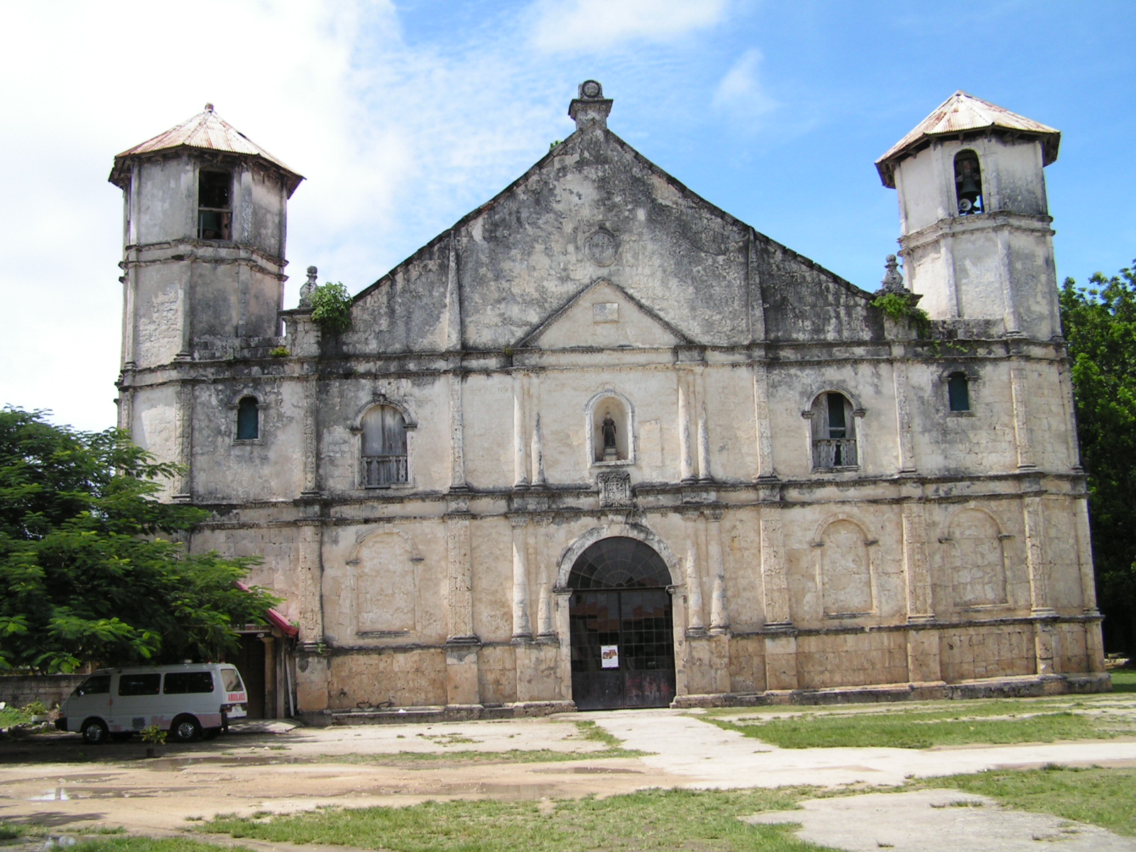
Dimiao's San Nicholas Church is one of the oldest stone churches of Bohol identified by its two twin bell towers at both sides of the church’s front façade. Way in front of the church building is a tower with the image of the Sacred Heart of Jesus where the “hugos” is done during dawn rites of Easter Sunday.
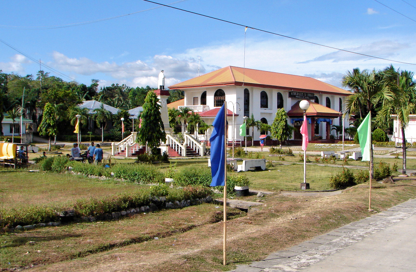
St. Nicholas is also the town’s patron saint whose feast day is celebrated on every 10 September. Across the church and across the circumferential road lies the town’s municipal hall which looks elegant with its white painted walls and red roof; a typical Spanish-designed building with prominent arched windows.
Fronting the Sacred Heart tower is a monument dedicated to the Philippines’ national hero, Dr. Jose P. Rizal whose statue stands on top of a stone pillar. The monument leads to the municipal hall although facing its side rather than the front view of the building.
Population is of 14,187 people according to the 2007 census; a far cry from its recorded population of 8,820 in 1897. It is politically subdivided into 35 barangays, to wit: Abihid, Alemania, Baguhan, Bakilid, Balbalan, Banban, Bauhugan, Bilisan, Cabagakian, Cabanbanan, Cadap-agan, Cambacol, Cambayaon, Canhayupon, Canlambong, Casingan, Catugasan, Datag, Guindaguitan, Guingoyuran, Ile, Lapsaon, Limokon Ilaod, Limokon Ilaya, Luyo, Malijao, Oac, Pagsa, Pangihawan, Sawang, Puangyuta, Tangohay, Taongon Cabatuan(mostly well-known as Taongon San Vicente) , Tawid Bitaog and Taongon Can-andam (mostly well-known as Taongon Señior.).
The people of Dimiao lives on farming, tuba gathering, rope making and fishing since it is located along the coast. Rice, corn, maguey, copra, rope and tuba are their most important products.
Situated along the coast, the town of Dimiao boasts of beaches with fine white sand. At Barangay Luyo is the well-loved Imelda Beach. On clear and sunny days, the Camiguin Island with the silhouette of Mt. Hibok-Hibok rising towards the clouds can be seen.
To know more about Dimiao Attractions and their own stories... Aside from the Imelda Beach Resort, the townsfolk boast of their century old church and convent and other attractions: the Soldier’s Cap and the Imelda Ruins at Barangay Sawang. The barangay of Taongon Can-andam are proud of their Fish Santuary and wonderful Sr. Santo Niño Chapel. and also Tangohay are proud of their sanctuary and beautiful St. Joseph Chapel.
Another Dimiao's Beach resort, the Kayla’a Beach Resort, is now ready to serve local and foreign tourists. The resort is located at Barangay Balbalan and situated on a wide stretch of fine white sand beach. With a swimming pool, restaurant and several cottages, guests are assured of an enjoyable stay.
The town has schools scattered throughout the barangays yet those located at the town proper are the Banban Elementary School, the Dimiao National High School and a private one, the St. Nicholas Academy. 90% of the inhabitants are literate and most speaks English and Filipino.
Contents
Barangays
Dimiao is politically subdivided into 35 barangays.
- Abihid
- Alemania
- Baguhan
- Bakilid
- Balbalan
- Banban
- Bauhugan
- Bilisan
- Cabagakian
- Cabanbanan
- Cadap-agan
- Cambacol
- Cambayaon
- Canhayupon
- Canlambong
- Casingan
- Catugasan
- Datag
- Guindaguitan
- Guingoyuran
- Ile
- Lapsaon
- Limokon Ilaod
- Limokon Ilaya
- Luyo - famous for their Imelda Beach
- Malijao
- Oac
- Pagsa
- Pangihawan
- Sawang - famous for their Ruins known as Imelda Ruins
- Puangyuta - famous for their red soil
- Tangohay - famous for their sanctuary and beautiful St. Joseph Chapel
- Taongon Cabatuan
- Tawid Bitaog
- Taongon Can-andam - Famous Sr. Sto. Niño Chapel and for their Fish Sanctuary
Scenes from Dimiao
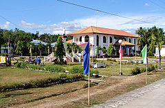 Town hall
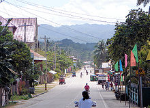 Main road
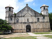 Catholic Church
Dimiao Attractions
The town of Dimiao has its share in Bohol's list of natural and man-made attractions, all worthy of a visit.
Dimiao Church
The Dimiao church is dedicated to San Nicolas Tolentino. It is centuries-old, built in the later half of the 19th century. The church houses some relics hailing from the Spanish Regime and is being preserved..
When the parish was founded, is uncertain, although baptism records dates back to the year 1750. A building stands behind the church that served once as a convent and is now a school..
Ermita Ruins
The Ermita Ruins are the ruins of a coralline limestone structure built during the Spanish Regime. It lies parallel to the nave of the St. Nicholas Tolentino Church in the town of Dimiao, Bohol. It was allegedly used as a military fortress, a chapel and a burial site of the members of the Spanish clergy. Archaeological excavations were done in 1995 and 1998 in a quest to uncover its mysterious past..
Balbalan Beach
Balbalan Beach lies on a long stretch of white sandy beach facing the Mindanao Sea. It is only 5 minutes drive away from the town center. The waters are unpolluted and crystal clear, very ideal for swimming. Out on the deep are colorful coral reefs – a haven for adventurous divers. Sailing is also a pastime in the area..
Imelda Beach
Imelda Beach boast of a stretch of white sand fringed with tall coconut palm trees. The waters are clear and unpolluted. The beach is fairly accessible, lying along the National Highway. It was once the venue of an encampment of the Boys and Girls Scouts of Bohol..
Dimiao Twin Falls
The Dimiao Twin Falls cascades over a cliff and is a beautiful sight to behold. Nestled 14 kilometers away from the highway, its rugged pathway is a challenge to trekkers who are rewarded with a panoramic view of the falls upon arrival. Dry land near the foot of the falls is ideal for picnics. .
Pahangog Twin Falls & Caverns
The Pahangog Twin Falls cascades over a 30-meter high cliff surrounded by a lush forest of tropical trees and flora. A natural basin was carved out from underneath the falling waters and serves as a natural swimming pool for bathers. .
Two caves lie near to the falls with rock formations carved out by centuries of gushing waters; one cavern has a naturally-contoured basin that fills up with water before flowing outwards from the cave..
Rice Terraces
The rice terraces of Dimiao are a wondrous sight. Although not occupying a large area as that of Mt. Banawe, the terraces are still beautiful to behold especially when it is covered and looks like a velvety green layered field or during near-harvest season when the fields turn into gold..
McArthur’s Cap
The McArthur’s Cap is a rock formation resembling an army officer’s cap that one encounters when entering the town of Dimiao. The rock formation has become an emblem and called such at the successful return of Gen. Douglas McArthur, considered by most post-war Filipinos as a hero, upon the defeat of the Japanese Army during World War II..
Badiang Peak
Badiang Peak is a rugged mountain of Dimiao which has been constantly visited by trekkers and mountain climbers. Hours of trekking along pathways and climbing over boulders are rewarded with a panoramic view of Dimiao and its neighboring lowlands from atop the mountain peak.
References
External links
- Municipality of Dimiao
- Philippine Standard Geographic Code
- 2000 Philippine Census Information
- 2007 Philippine Census Information

Bilar Lila 
Valencia  Dimiao

Bohol Sea Municipalities Alburquerque • Alicia • Anda • Antequera • Baclayon • Balilihan • Batuan • Bien Unido • Bilar • Buenavista • Calape • Candijay • Carmen • Catigbian • Clarin • Corella • Cortes • Dagohoy • Danao • Dauis • Dimiao • Duero • Garcia Hernandez • Getafe • Guindulman • Inabanga • Jagna • Lila • Loay • Loboc • Loon • Mabini • Maribojoc • Panglao • Pilar • President Carlos P. Garcia • Sagbayan • San Isidro • San Miguel • Sevilla • Sierra Bullones • Sikatuna • Talibon • Trinidad • Tubigon • Ubay • ValenciaComponent city Categories:- Municipalities of Bohol


Wikimedia Foundation. 2010.