- Tihamah
-
"Tihama" redirects here. For other uses, see Tihama (disambiguation).
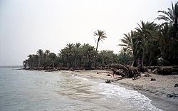
Tihamah or Tihama (Arabic: تهامة Tihāmah) is a narrow coastal region of Arabia on the Red Sea. It is currently divided between Saudi Arabia and Yemen. In a broad sense, Tihamah refers to the entire coastline from the Gulf of Aqaba to the Bab el Mandeb Strait but it more often refers only to its southern half, starting just south of Jeddah and running parallel to Asir and Yemen. Unlike the inland regions, it is made up of sand dunes and plains and is largely arid except for a few oases. Important urban centers of the region include Al Hudaydah, Mocha, and Zabid in Yemen and Jizan, Al-Qunfudhah, and Al Lith in Saudi Arabia. Most of the Tihama coastline is hazardous to approaching vessels, and harbors are therefore few and far between, especially in the northern half.
In modern times, Tihama has come to be viewed as made up of three sections, each named after the inland region adjacent to it. The northern section, therefore, is known as Tihamat al-Hejaz, the middle section as Tihamat 'Asir, and the southern section as Tihamat al-Yemen. The middle and southern sections are part of the Arabian Peninsula coastal fog desert ecoregion.
The temperatures in Tihamah are probably some of the hottest on earth. A normal summer day in Al Hudaydah can be 43 degrees Celsius (110 Fahrenheit) with the humidity of around 40-60% at noon, causing the heat index to be dangerously high. Only the inhabitants can normally withstand the heat, and highland Yemenis often find it very difficult to stay in the Tihamah area.
There have been arguments that the entire Tihamah area legally belongs to Saudi Arabia due to problems within the Treaty of Taif and that these were part of the nation of Asir conquered by the Saudis in the early 1920s. With increasing violence in Yemen the calls for it being ceded to Saudi Arabia have increased.[1]
References
External links
World deserts Africa Asia - Ad-Dahna
- Arabian
- Aral Karakum
- Aralkum
- Badain Jaran
- Betpak-Dala
- Cholistan
- Dasht-e Kavir
- Dasht-e Lut
- Dasht-e Margoh
- Dasht-e Naomid
- Gurbantünggüt
- Gobi
- Hami
- Indus Valley
- Judean
- Karakum
- Kharan
- Kumtag
- Kyzyl Kum
- Lop
- Nefud
- Negev
- Ordos
- Qaidam
- Rub' al Khali
- Russian Arctic
- Registan
- Saryesik-Atyrau
- Syrian
- Taklamakan
- Tengger
- Thal
- Thar
- Tihamah
- Ustyurt Plateau
- Wahiba Sands
- Liwa
Europe North America - Alvord
- Amargosa
- Baja California
- Black Rock
- Carcross
- Channeled scablands
- Chihuahuan
- Escalante
- Forty Mile
- Gran Desierto de Altar
- Great Basin
- Great Salt Lake
- Great Sandy
- Jornada del Muerto
- Kaʻū
- Lechuguilla
- Mojave
- North American Arctic
- Owyhee
- Painted Desert
- Red Desert
- Sevier
- Smoke Creek
- Sonoran
- Tule (Arizona)
- Tule (Nevada)
- Yp
- Yuha
- Yuma
Australia South America Polar regions New Zealand Categories:- Landforms of Saudi Arabia
- Landforms of Yemen
- Yemen geography stubs
- Saudi Arabia geography stubs
Wikimedia Foundation. 2010.

