- Kumtag Desert
-
 Kumtag Desert
The Kumtag Desert, Kumtagh Desert or Desert of Kum-tag (Chinese: 库姆塔格沙漠; pinyin: Kùmǔtǎgé Shāmò Turkish:Kumdağ), literally "sand mountain desert" in Old Turkic language (Kum meaning sand and Tag meaning Mountain), is an arid landform in Northwestern China, which was proclaimed as a national park in the year 2002.
Contents
Definitions
1. Broad definition: The oval Tarim Basin with its central Taklamakan Desert is bounded on the north, west and south by mountains. On the east side the Kumtag is an unbroken plain about 100 miles from north to south that runs from the Taklamakan to Gansu and Mongolia. Many modern maps do not show a Kumtag in this sense which implies that the usage may be out of date.
The Kumtag Desert is a section of the Taklamakan Desert which lies east-southeast of the Desert of Lop. It is on the other side of the Kara-koshun and reaches north-eastwards as far as the vicinity of the town of Sa-chow and the lake of Kara-nor, or Kala-chi. It is bordered by Dunhuang in the east, Tian Shan in the north, and with an area of 22,800+ square kilometers. Its southern rim is marked by a labyrinth of hills, dotted in groups and irregular clusters,worn down as it were to mere fragments of their former skeletal structure. Between these and the Altyn-Tagh, intervenes a broad latitudinal valley, seamed with watercourses that come down from the foothills of the Altyn-tagh. Beside these scrubby desert plants of the usual character maintain a precarious existence. Water reaching them in some instances at intervals of years only. This part of the desert has a general slope northwest towards the relative depression of the Kara-koshun. A noticeable feature of the Kum-tagh is the presence of large accumulations of drift-sand, especially along the foot of the crumbling desert ranges, where it rises into dunes sometimes as much as 250 feet (76 m) in height and climbs half-way up the flanks of ranges themselves.
Administratively, the desert is located in the Ruoqiang (Qakilik) County of Xinjiang and Aksai Kazakh Autonomous County and Dunhuang City of Gansu, near their border with Qinghai.
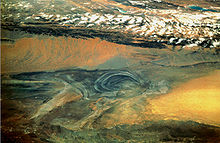 Lop Nor with the orange Kumtag to the southeast. To the north is the Tian Shan mountains forming the north border of the Tarim basin
2. Narrow Definition: A map published by the National Geographic Society[1] shows a much smaller Kumtag. This is a rectangle with a northwest corner south of Lop Nor, a southern edge along the Altyn-Tagh and an eastern edge just beyond the Gansu border. Near the northeast corner is the Jade Gate which is often taken as the eastern end of the Great Wall. From space it appears as a belt of orange sand dunes. This is probably the 2500 square kilometer area mentioned below.
Ongoing desertification
The Kumtag Desert is expanding and threatening to engulf previously productive lands with its arid wasteland character.[2] Several years prior the estimated size of the desert was 2500 square kilometres, but with recent expansion, the Kumtag Desert is already considerably larger as of 2008.
The Kumtag Desert is continuing a process of expansion that is the result of centuries of overgrazing of this region that is beyond its carrying capacity. According to the AFP news report of November, 2007: "Towering sand dunes [of the Kumtag Desert] loom over the ancient Chinese city of Dunhuang".[2] According to Hogan: "Rapid expansion of the Kumtag Desert and other dunes formations threaten to engulf Yungang and other archaeological sites"; moreover, the desertification adjacent to the Kumtag Desert is part of a larger problem in northern China where the present rate of desertification in this single region of China (e.g. Northern China) now exceeds 1,000 square miles (2,600 km2) per annum.[3] To mitigate the desertification, the town of Dunhuang has placed severe limitations on immigration, and has also placed restrictions on new water-well development or new farm additions.[2]
Prevailing winds and sands
The prevailing winds in this region would appear to blow from the west and northwest during the summer, winter and autumn. Though in spring, when they certainly are more violent, they no doubt come from the northeast, as in the desert of Lop. The arrangement of the sand here agrees perfectly with the law laid down by Potanin, that in the basins of Central Asia the sand is heaped up in greater mass on the south, all along the bordering mountain ranges where the floor of the depressions lies at the highest level. The country to the north of the desert ranges is thus summarily described by Sven Hedin: "The first zone of drift sand is succeeded by a region that exhibits proofs of wind modelling on an extraordinarily energetic and well-developed scale, the results corresponding to the jardangs and the wind-eroded gullies of the Desert of Lop. Both sets of phenomena lie parallel to one another; from this we may infer that the winds which prevail in the two deserts are the same. Next comes, sharply demarcated from the zone just described, a more or less thin kamish steppe growing on level ground; and this in turn is followed by another very narrow belt of sand, immediately south of Achik-kuduk Finally in the extreme north we have the characteristic and sharply defined belt of kamish steppe, stretching from eastnortheast to westsouthwest and bounded on north and south by high, sharp cut clay terraces.
"At the points where we measured them the northern terrace was 113 feet (34 m) high and the southern 853/4 feet....Both terraces belong to the same level, and would appear to correspond to the shore lines of a big bay of the last surviving remnant of the Central Asian Mediterranean. At the point where I crossed it the depression was 6 to 7 miles (11 km), wide, and thus resembled a flat valley or immense river-bed."[citation needed]
See also
References
 This article incorporates text from a publication now in the public domain: Chisholm, Hugh, ed (1911). Encyclopædia Britannica (11th ed.). Cambridge University Press.
- ^ National Geographic Atlas of China',2008, page 29
- ^ a b c Ancient Chinese town on front lines of desertification battle, AFP, Nov 20, 2007
- ^ C.Michael Hogan, Silk Road, North China, The Megalithic Portal, ed. A. Burnham
External links
Coordinates: 42°42′00″N 90°16′00″E / 42.7°N 90.2667°E
World deserts Africa Asia - Ad-Dahna
- Arabian
- Aral Karakum
- Aralkum
- Badain Jaran
- Betpak-Dala
- Cholistan
- Dasht-e Kavir
- Dasht-e Lut
- Dasht-e Margoh
- Dasht-e Naomid
- Gurbantünggüt
- Gobi
- Hami
- Indus Valley
- Judean
- Karakum
- Kharan
- Kumtag
- Kyzyl Kum
- Lop
- Nefud
- Negev
- Ordos
- Qaidam
- Rub' al Khali
- Russian Arctic
- Registan
- Saryesik-Atyrau
- Syrian
- Taklamakan
- Tengger
- Thal
- Thar
- Tihamah
- Ustyurt Plateau
- Wahiba Sands
- Liwa
Europe North America - Alvord
- Amargosa
- Baja California
- Black Rock
- Carcross
- Channeled scablands
- Chihuahuan
- Escalante
- Forty Mile
- Gran Desierto de Altar
- Great Basin
- Great Salt Lake
- Great Sandy
- Jornada del Muerto
- Kaʻū
- Lechuguilla
- Mojave
- North American Arctic
- Owyhee
- Painted Desert
- Red Desert
- Sevier
- Smoke Creek
- Sonoran
- Tule (Arizona)
- Tule (Nevada)
- Yp
- Yuha
- Yuma
Australia South America Polar regions New Zealand Xinjiang topics General Geography Cities • Tian Shan • Dzungarian Basin • Tarim Basin • Gurbantünggüt Desert • Kumtag Desert • Taklimakan Desert • Turpan Depression • Karakoram Mountains • Altai Mountains • Tian Shan • Kunlun Shan • Pamir Mountains • Torugart Pass • Karakoram PassEducation Culture Cuisine Dapanji • Sangza • Samsa • Youtazi • Pamirdin • Xurpa • Tohax • Tunurkawab • Chinese Islamic cuisineVisitor attractions Apak Khoja and Xiang Fei Tomb • Flaming Mountains • Jiaohe Ruins • Gaochang • Grand Bazaar, Ürümqi • Id Kah Mosque • Karakul Lake • Kizil Caves • Ruins of NiyaCategories:- Sites along the Silk Road
- Deserts of China

Wikimedia Foundation. 2010.