- Ürümqi
-
For the county, see Ürümqi County.
Ürümqi
ئۈرۈمچی
乌鲁木齐— Prefecture-level city — ئۈرۈمچى شەھىرى · 乌鲁木齐市 From top: A panoramic view of Ürümqi's CBD, Red Mountain (Hong Shan), Ürümqi Night Market, and a view of Tian Shan from Ürümqi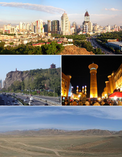 Ürümqi (red) in Xinjiang (orange) and China
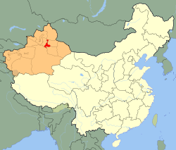
Coordinates: 43°48′N 87°35′E / 43.8°N 87.583°E Country People's Republic of China Region Xinjiang County-level divisions 8 Government – CPC Committee Secretary Zhu Hailun[1] – Mayor Jerla Isamudin (吉尔拉·衣沙木丁 / جەرۇللاھ ھېسامىدىن) Area – Prefecture-level city 10,989 km2 (4,242.9 sq mi) – Urban 828 km2 (319.7 sq mi) – Metro 4,422 km2 (1,707.3 sq mi) Population (2010 census) – Prefecture-level city 3,110,280 – Density 283/km2 (733.1/sq mi) – Urban 2,302,146 – Urban density 2,780.4/km2 (7,201.1/sq mi) – Metro 2,744,280 – Metro density 620.6/km2 (1,607.3/sq mi) Time zone China Standard Time (UTC+8) Postal code 830000 Area code(s) 991 License plate prefixes 新A GDP (2008) CNY 102 billion - per capita CNY 43,211 ISO 3166-2 CN-65-01 Website http://www.urumqi.gov.cn/ (Chinese) Ürümqi Chinese name Simplified Chinese 乌鲁木齐 Traditional Chinese 烏魯木齊 Literal meaning beautiful pasture Transcriptions Mandarin - Hanyu Pinyin Wūlǔmùqí Cantonese (Yue) - Jyutping wu1lou5muk6cai4 Mongolian name Mongolian ᠪᠠᠶᠠᠨᠭᠣᠣᠯ Uyghur name Uyghur Ereb Yéziqi:
ئۈرۈمچی
Latin Yéziqi:
Ürümchi
Yengi Yeziķ:
Ürümqi
Siril Yéziqi:
Үрүмчи
pronounced [yrymˈtʃi]Ürümqi (
 /uːˈruːmtʃi/; Uyghur: ئۈرۈمچی, ULY: Ürümchi; Chinese: 乌鲁木齐; pinyin: Wūlǔmùqí), formerly Tihwa (Chinese: 迪化; pinyin: Dǐhuà; Wade–Giles: Tihwa), is the capital of Xinjiang Uyghur Autonomous Region of the People's Republic of China, in the northwest of the country.
With a built up population of 2,744,280 as of 2010 census (5 urban districts plus Midong) and 2.3 in urban districts, Ürümqi, whose name means "beautiful pasture" in the Mongolian language of the Dzungar people,[2] is the largest city in China's western interior. Since the 1990s Ürümqi has developed economically and now serves as a regional transport node and commercial centre.
Contents
History
Although Ürümqi is situated near the northern route of the Silk Road, it is likely to be a relatively young city. According to Chinese scholars, during the 22nd year of Emperor Taizong's reign in the Tang Dynasty, AD 648, the Tang government set up the town of Luntai in the ancient town seat of Urabo,[3] 10 kilometers from the southern suburb of present-day Ürümqi. Ancient Luntai Town was a seat of local government, and collected taxes from the caravans along the northern route of the Silk Road.
Steppe peoples had used the location, the pass between the Bogda Shan mountains to the East and the Tien Shan mountains to the west, connecting the Dzungar Basin to the north and the Turpan Depression in the south. In the 7th century the location was controlled by tribes of the Göktürks (Turkic Khaganate). In 742 AD, the Göktürk Khaganate split as the Uyghur tribes and the Eastern "wing" of the Göktürks broke off to form the Uyghur Khaganate. Ürümqi sat in the center of this empire until 1220, when it merged with the Mongol Empire under Genghis Khan. After the division of the Mongol Empire, the town then passed into the Chagatai Khanate where Sufi Islam dominated Ürümqi culture. Around 1670 the Uyghur tribes revolted from the Chagatais and united with the Dzungar tribes to form Zunghar Khanate. Ürümqi remained a small town, and less important than the oasis and Silk Road trade center Turpan 200 km to the southeast.
Thus, little is heard of the region following the Tang Dynasty in the Chinese texts until the Qing Dynasty conquest of Dzungaria in 1755 under the Emperor Qianlong. The Dzungars were deliberately exterminated in a brutal campaign of ethnic genocide. One writer, Wei Yuan, described the resulting desolation in what is now northern Xinjiang as: "an empty plain for a thousand li, with no trace of man." After 1759 state farms were established, "especially in the vicinity of Urumchi, where there was fertile, well-watered land and few people."[4] It has been estimated that more than a million people were slaughtered, and it took generations for it to recover.[5]
During the Qing Dynasty (1763) the Qianlong Emperor named the expanded town of Luntai "Dihua" (Chinese:迪化; pinyin: Díhuà; Manchu: Wen de dahabure fu), meaning "to enlighten." In 1884, the Guangxu Emperor established Xinjiang as a Province, with Dihua as its capital.[6]
The Battle of Urumqi (1870) took place in 1870 between the Turkic Muslim forces of Yaqub Beg against the Dungan Muslim forces of Tuo Ming (Daud Khalifa). With the help of Xu Xuegong's Han chinese militia, Yaqub beg's forces defeated the Dungans.[7][8][9][10][11]
During the Kumul Rebellion the Battle of Urumqi (1933) and the Battle of Urumqi (1933–34) took place between the forces of Ma Zhongying's 36th Division (National Revolutionary Army) and Jin Shuren and Sheng Shicai's provincial forces. At the second battle Ma was assisted by Han chinese General Zhang Peiyuan.
Following the founding of the People's Republic of China, on 1 February 1954, the city was renamed Ürümqi, meaning "beautiful pasture" in the Mongolian language of the Dzungar people.
The city was the site of major rioting in July 2009 due to conflicts between Han and Uyghur ethnic groups in which nearly 200 people were left dead; most of the victims were Han-Chinese. Reports of extensive police retaliation against the Uyghur minority have circulated ever since, despite the Chinese government having shut down access to emails and overseas phone calls.
Geography
The largest city in western China, Ürümqi has earned a place in the Guinness Book of Records as the most remote city from any sea in the world. It is about 2,500 kilometres (1,600 mi) from the nearest coastline as Ürümqi is the closest major city to the Eurasian pole of inaccessibility, although Karamay and Altay, both in Xinjiang, are closer.[12] The city has an administrative area of 10,989 square kilometres (4,243 sq mi) and has an average elevation of 800 metres (2,600 ft).
Climate
In Ürümqi a semi-arid climate (Köppen climate classification BSk) prevails, with very large differences between summer and winter, hot summers, with a July daily average of 23.7 °C (74.7 °F), and cold winters, with a January daily average of −12.6 °C (9.3 °F). The annual average temperature is 6.9 °C (44.4 °F). The city is semi-arid, with its summers slightly wetter than its winters. Yet sunny weather is more likely in the warmer months, and relative humidity is the lowest during summer. Its annual precipitation is about 290 millimetres (11.4 in). Extreme temperatures have ranged from −41.5 °C (−43 °F) to 42.1 °C (108 °F).[13]
Climate data for Ürümqi Month Jan Feb Mar Apr May Jun Jul Aug Sep Oct Nov Dec Year Average high °C (°F) −7.4
(18.7)−4.7
(23.5)2.7
(36.9)16.1
(61.0)23.1
(73.6)27.6
(81.7)30.1
(86.2)29.0
(84.2)23.1
(73.6)13.2
(55.8)2.0
(35.6)−4.4
(24.1)12.6 Average low °C (°F) −16.6
(2.1)−13.7
(7.3)−5.4
(22.3)4.8
(40.6)11.2
(52.2)16.1
(61.0)18.2
(64.8)16.7
(62.1)11.2
(52.2)3.1
(37.6)−5.9
(21.4)−12.9
(8.8)2.2 Precipitation mm (inches) 10.4
(0.409)10.0
(0.394)18.5
(0.728)32.3
(1.272)38.9
(1.531)36.2
(1.425)30.4
(1.197)23.3
(0.917)26.2
(1.031)26.3
(1.035)19.1
(0.752)14.6
(0.575)286.3
(11.272)% humidity 78 77 71 48 43 43 43 41 44 58 74 78 58.2 Avg. precipitation days (≥ 0.1 mm) 9.2 7.2 7.2 6.8 6.8 8.0 8.4 6.3 5.0 5.5 6.9 9.6 86.9 Sunshine hours 101.6 128.8 180.5 248.0 283.3 282.7 298.7 301.0 262.6 224.4 127.4 84.3 2,523.3 Source: China Meteorological Administration Administrative divisions
Ürümqi currently comprises 8 county-level subdivisions: 7 districts and 1 county.
Map # Name Hanzi Hanyu Pinyin Uyghur
(kona yezik̡)Uyghur Latin
(yengi yezik̡)Population (2003 est.) Area (km²) Density (/km²) 
City proper 1 Tianshan District 天山区 Tiānshān Qū تىيانشان رايونى Tiyanshan Rayoni 490,000 171 2,865 2 Saybagh District 沙依巴克区 Shāyībākè Qū سايباغ رايونى Saybagh Rayoni 450,000 422 1,066 3 Xinshi District 新市区 Xīnshì Qū يېڭىشەھەر رايونى Yéngisheher Rayoni 390,000 143 2,727 4 Shuimogou District 水磨沟区 Shuǐmògōu Qū شۇيموگۇ رايونى Shuymogu Rayoni 180,000 92 1,957 Suburban 5 Toutunhe District 头屯河区 Tóutúnhé Qū تۇدۇڭخابا رايونى Tudungxaba Rayoni 120,000 276 435 6 Dabancheng District 达坂城区 Dábǎnchéng Qū د اۋانچىڭ رايونى D Avanchyng Rayoni 40,000 5,188 8 7 Midong District 米东区 Mǐdōng Qū میدونگ رايونى Midong Rayoni 290,000 3,594 56 Rural 8 Ürümqi County 乌鲁木齐县 Wūlǔmùqí Xiàn ئۈرۈمچى ناھىيىسى Ürümchi Nahiyisi 80,000 4,332 18 Demographics
According to the 2000 census, Ürümqi has 2,081,834 inhabitants, with a population density of 174.53 inhabitants/km².[14]
Ethnicity Population Percentage Han 1.567.562 75.3% Uyghur 266.342 12.79% Hui 167.148 8.03% Kazakhs 48.772 2.34% Manchu 7.682 0.37% Mongol 7.252 0.35% Xibe 3.674 0.18% Russian 2.603 0.13% Tu 1.613 0.08% Kyrgyz 1.436 0.07% Uzbek 1.406 0.07% Zhuang 878 0.04% Tatar 767 0.04% Tibetan 665 0.03% Dongxiang 621 0.03% Miao 620 0.03% Korean 588 0.03% Other 2.205 0.09% Economy
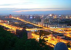 Outer ring road bridges in Urumqi at night
Ürümqi is a major industrial center within Xinjiang. Ürümqi, together with Karamay and Korla, account for 64.5% of the total industrial output of Xinjiang. Ürümqi is also the largest consumer center in the region, recording ¥41.9 billion retail sales of consumer goods in 2008, an increase of 26% from 2007. The GDP per capita reached US$6,222 in 2008.[15] According to statistics, Urumqi ranked 7th in 2008 by the disposable income for urban residents among cities in Western China.[16] Ürümqi has been a central developmental target for the China Western Development project that the Central Government is pursuing.
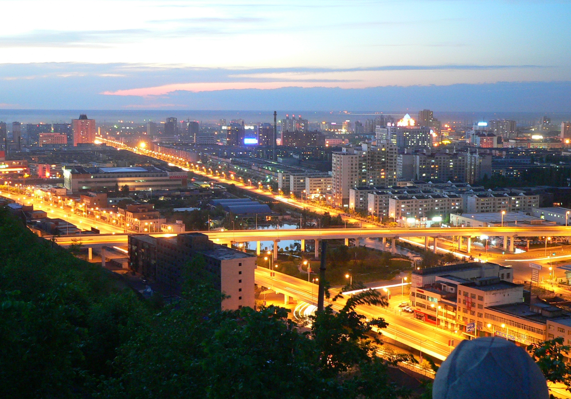
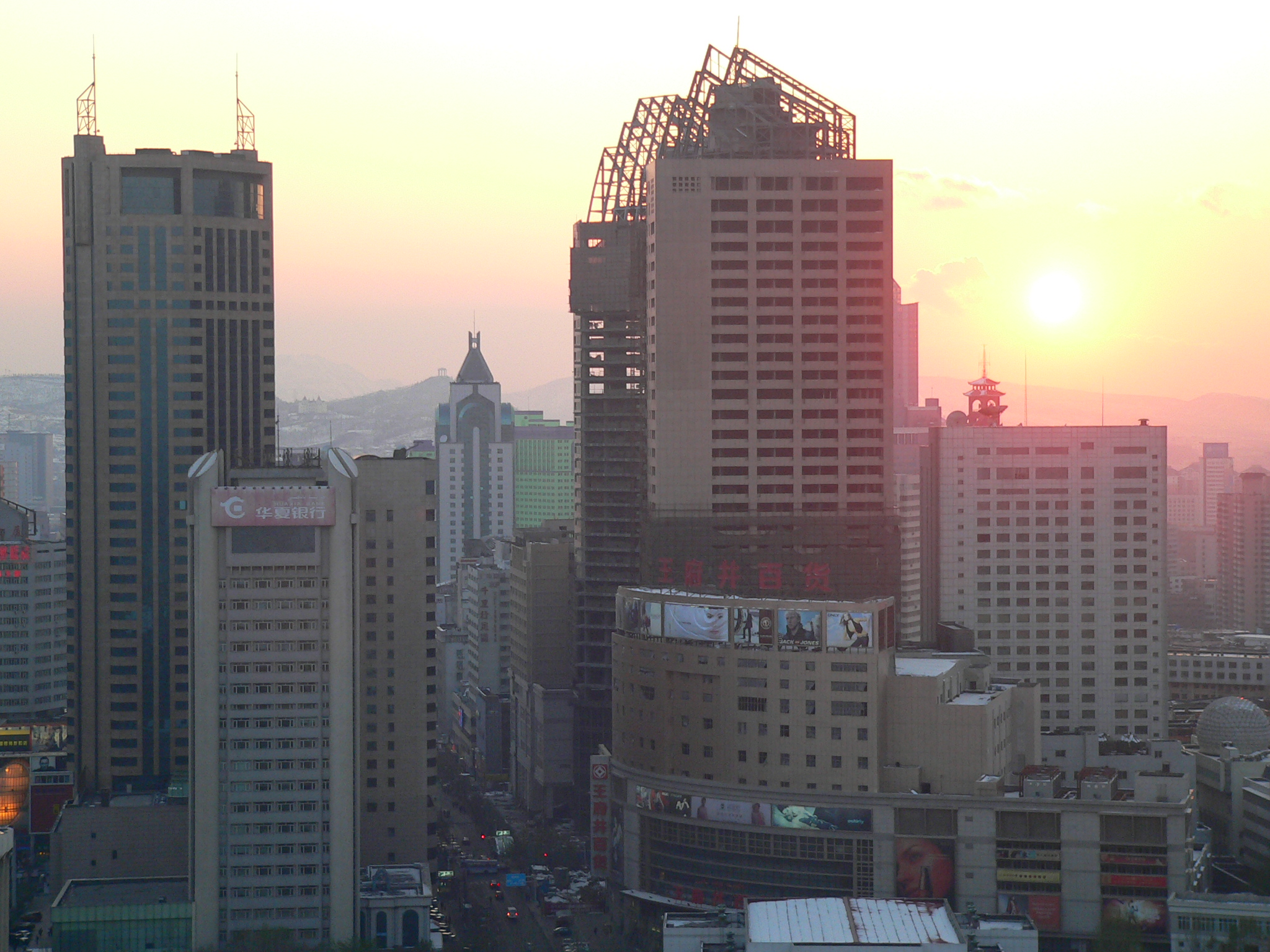
 Partial panorama of Urumqi at dusk, April 2008
The Urumqi Foreign Economic Relations and Trade Fair (Chinese: 乌洽会) has been held annually since 1991. Its purpose is to promote domestic and foreign markets. The 17th Fair has attracted participants from the Ministry of Commerce and the China Council for Promotion of International Trade.[17]
As the economic center, Urumqi has expanded its urban area since the 1990s. The CBDs in the city increased rapidly all around the major districts. China CITIC Bank Mansion (中信银行大厦), located in one of the CBDs in North Xinhua Road, is the tallest building in Urumqi and Xinjiang; with a height of 229 metres, it is also the tallest in Northwestern China and Central Asia. Lacking a subway, the city built an outer ring road (外环路) in 2003, which considerably facilitates transport. Zhongshan Road (Sun Yat-sen Road, Chinese: 中山路) in Urumqi has been one of the ten most famous commercial streets in the People's Republic of China since 2005 (through official appraisals). The others are Wangfujing, etc. The commercial street of Zhongshan Road has the largest computer, mobile phone and consumer electronics market, i.e. Baihuacun, Cyber Digital Plaza and Fountain Plaza, in the Xinjiang Uyghur Autonomous Region; it is believed to be the focal point of technological products in Urumqi.
Tourism
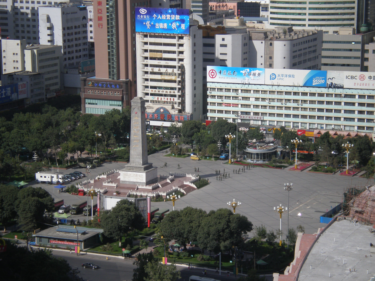
 People's Square
- The International Grand Bazaar Xinjiang (Chinese: 新疆国际大巴扎, Uyghur: شىنجاڭ خەلقئارا چوڭ بازىرى) is an Islamic bazaar located on South Jiefang Road (解放南路).
- Hong Shan Mountain (红山) is the symbolic scenic spot of Urumqi, located in the Hong Shan Park. The highest point of the park contains a three story temple-like structure which houses some spectacular photography of the surrounding area. The third floor contains a model of the city.
- Glacier No. 1 (一号冰川), origin of Urumqi River, is the largest glacier located near a city in China.
- People's Square (人民广场)
- Nanhu Square (南湖广场)
- Xinjiang Uygur Autonomous Region Museum (新疆维吾尔自治区博物馆)
- Shuimugou Hot Springs (水磨沟温泉) is located 5 km northeast of Urumqi.
- Xinjiang Silk Road Museum (新疆丝绸之路博物馆) is located right next to the Grand Bazaar at No.160 Shengli Road. It is located on the fourth and fifth floor of a very large European style building which houses a shopping complex as well. Most of the exhibits have English names as well and some of their guides speak some English.
- Ürümqi City Museum (乌鲁木齐博物馆) is located at South Nanhu Road 123 (南湖南路 123).
Education
Urumqi has many educational campuses including Xinjiang University, Xinjiang Normal University, Xinjiang Agricultural University , Xinjiang Medical University and many others.
Universities
- Xinjiang University (新疆大学)
- Xinjiang Medical University (新疆医科大学)
- Xinjiang Normal University (新疆师范大学)
- Xinjiang Agricultural University (新疆农业大学)
- Xinjiang Arts Institute (新疆艺术学院)
- Xinjiang University of Finance & Economics (新疆财经大学)
High schools
- Ürümqi No.1 High School (乌鲁木齐市第一中学)
- Ürümqi No.8 Middle School (乌鲁木齐市第八中学)
- Xinjiang Experimental High School (新疆实验中学)
- Xinjiang Production and Construction Corps No.2 High School (新疆生产建设兵团第二中学)
- Senior High School of Ürümqi (乌鲁木齐市高级中学)
- Bayi Middle School of Ürümqi (乌鲁木齐市八一中学)
Transportation
Air
Ürümqi is served by the Ürümqi Diwopu International Airport. The airport is one of the five major airports in the People's Republic of China. It is also a hub for China Southern Airlines. It has been rumored that a new airline China Central Airlines will start operations at the airport sometime in late 2010.
Rail
- Ürümqi Railway Station
Ürümqi is Xinjiang's main rail hub. It is the western terminus of the Lanzhou-Xinjiang (Lanxin) and Ürümqi-Dzungaria (Wuzhun) Railway, and the eastern terminus of the Northern Xinjiang (Beijiang) and the Second Ürümqi-Jinghe Railway. The Beijiang and the Lanxin Lines form part of the Trans-Eurasian Continental Railway, which runs from Rotterdam through the Alataw Pass on the Kazkhstan border to Ürümqi and on to Lanzhou and Lianyungang. There is also a high-speed rail line under construction, which is expected to connect Ürümqi with Xining and Lanzhou in 2014.
Road
Many roads North & West typically shut down rapidly in the early October period, remaining shut until winter breaks. Trains should remain operational.
Media
 Logo of Urumqi Television Station, shaped after Hong Shan
The Xinjiang Networking Transmission Limited operates the Urumqi People's Broadcasting Station and the Xinjiang People's Broadcasting Station, broadcasting in the Mandarin, Uyghur, Kazakh, Mongolian, Russian and the Kyrgyz languages.
The Xinjiang Television Station (XJTV), located in Urumqi, is the major TV broadcasting station in the Xinjiang Uyghur Autonomous Region. The local television station for Urumqi city is Urumqi Television Station (UTV)(乌鲁木齐电视台).
Sport
- Xinjiang Flying Tigers is a major basketball team in the region.
- Xinjiang Ticai is a local football team in the Chinese Football Association Yi League
International relations
Main article: List of twin towns and sister cities in ChinaTwin towns — Sister cities
Ürümqi is twinned with:
City Region Country Peshawar  Khyber Pakhtunkhwa
 Pakistan
Bishkek  Chuy Province
 Kyrgyzstan
Almaty  Almaty1
 Kazakhstan
Chelyabinsk  Chelyabinsk Oblast
 Russia
^1 Almaty is a state-level city of Kazakhstan
References and footnotes
- ^ "Urumqi party chief, Xinjiang police chief sacked". Xinhua. 5 September 2009. http://news.xinhuanet.com/english/2009-09/05/content_12001223.htm. Retrieved 5 September 2009.
- ^ "http://www.travelchinaguide.com/attraction/xinjiang/urumqi/valley.htm". Travelchinaguide.com. http://www.travelchinaguide.com/attraction/xinjiang/urumqi/valley.htm. Retrieved 19 February 2010.
- ^ "Urumqi". Chinatoday.com.cn. 1 February 1954. http://www.chinatoday.com.cn/English/chinatours/urumqi.htm. Retrieved 19 February 2010.
- ^ Millward (2007), pp. 95, 104
- ^ Tyler (2003), p. 55
- ^ "Online Encyclopædia Britannica". Britannica.com. 31 January 2007. http://www.britannica.com/EBchecked/topic/620188/Urumqi/278262/History. Retrieved 19 February 2010.
- ^ James A. Millward (2007). Eurasian crossroads: a history of Xinjiang. Columbia University Press. p. 120. ISBN 0231139241. http://books.google.com/books?id=8FVsWq31MtMC&pg=PA118&dq=yaqub+beg+unpopular&hl=en&ei=Pz8ITe_DMYGdlge-5bCeAQ&sa=X&oi=book_result&ct=result&resnum=1&ved=0CCMQ6AEwAA#v=onepage&q=in%20his%20first%20attack%20on%20the%20tungan%20beg%20joined%20by%20xu%20xuegong%20han%20chinese&f=false. Retrieved 2010-06-28.
- ^ Ho-dong Kim (2004). Holy war in China: the Muslim rebellion and state in Chinese Central Asia, 1864-1877. Stanford University Press. p. 96. ISBN 0804748845. http://books.google.com/books?id=AtduqAtBzegC&dq=doing+fuxiang+russian&q=anchu#v=onepage&q=brother%20fifteen%20hundred%20han%20chinese&f=false. Retrieved 2010-06-28.
- ^ John King Fairbank, Kwang-ching Liu, Denis Crispin Twitchett (1980). Late Ch'ing, 1800-1911. Cambridge University Press. p. 223. ISBN 0521220297. http://books.google.com/books?id=pEfWaxPhdnIC&dq=t%27o+ming+yakub&q=jihad#v=onepage&q=religious%20war%20against%20the%20tungans%20also%20sunnis&f=false. Retrieved 2010-06-28.
- ^ John King Fairbank, Kwang-ching Liu, Denis Crispin Twitchett (1980). Late Ch'ing. Cambridge University Press. p. 224. ISBN 0521220297. http://books.google.com/books?id=pEfWaxPhdnIC&dq=t%27o+ming+yakub&q=jihad#v=onepage&q=hsu%20han%20militia&f=false. Retrieved 2010-06-28.
- ^ Cyril E. Black, Louis Dupree, Elizabeth Endicott-West, Eden Naby (1991). The Modernization of Inner Asia. M.E. Sharpe. p. 45. ISBN 0873327799. http://books.google.com/books?id=FoIE4laY7JcC&pg=PA45&dq=yakub+beg+islamic+law&hl=en&ei=YkIITYbkPIP7lwfgp8iWAQ&sa=X&oi=book_result&ct=result&resnum=10&ved=0CFQQ6AEwCQ#v=onepage&q=yakub%20beg%20drove%20dungans&f=false. Retrieved 2010-11-28.
- ^ Google Maps
- ^ "Extreme Temperatures Around the World". http://www.mherrera.org/temp.htm. Retrieved 2010-12-01.
- ^ 2000年人口普查中国民族人口资料,民族出版社,2003/9 (ISBN 7-105-05425-5)
- ^ "hktdc.com – Profiles of China Provinces, Cities and Industrial Parks". Tdctrade.com. http://www.tdctrade.com/mktprof/china/xinjiang.htm. Retrieved 19 February 2010.
- ^ "乌鲁木齐人均可支配收入增长居西部十省第8位". http://www.nxein.com/zhjj/mzqyjj/200711/5573.html.
- ^ 17th Urumqi Trade Fair opens "17th Urumqi Trade Fair opens — CCTV International". CCTV.com. http://www.cctv.com/program/bizchina/20080902/102963.shtml 17th Urumqi Trade Fair opens.
External links
Xinjiang topics Ürümqi (capital)General Geography Cities • Tian Shan • Dzungarian Basin • Tarim Basin • Gurbantünggüt Desert • Kumtag Desert • Taklimakan Desert • Turpan Depression • Karakoram Mountains • Altai Mountains • Tian Shan • Kunlun Shan • Pamir Mountains • Torugart Pass • Karakoram PassEducation Culture Cuisine Dapanji • Sangza • Samsa • Youtazi • Pamirdin • Xurpa • Tohax • Tunurkawab • Chinese Islamic cuisineVisitor attractions Apak Khoja and Xiang Fei Tomb • Flaming Mountains • Jiaohe Ruins • Gaochang • Grand Bazaar, Ürümqi • Id Kah Mosque • Karakul Lake • Kizil Caves • Ruins of NiyaMetropolitan cities of the People's Republic of China Municipalities and National central cities Regional central cities Special administrative regions Sub-provincial cities (not included above) Separate state-planning cities (not included above) Provincial capitals (not included above) Autonomous regional capitals Comparatively large cities (not included above) Special economic zone cities (not included above) Coastal development cities (not included above) XPCC / Bingtuan cities State-level new areas Pudong New Area (Shanghai) · Binhai New Area (Tianjin) · Liangjiang New Area (Chongqing) · Zhoushan Archipelago New Area (Zhoushan)Most populous metropolises in the People's Republic of China Provincial capitals of the People's Republic of China Changchun, Jilin · Changsha, Hunan · Chengdu, Sichuan · Fuzhou, Fujian · Guangzhou, Guangdong · Guiyang, Guizhou · Haikou, Hainan · Hangzhou, Zhejiang · Harbin, Heilongjiang · Hefei, Anhui · Hohhot, Inner Mongolia · Jinan, Shandong · Kunming, Yunnan · Lanzhou, Gansu · Lhasa, Tibet · Nanchang, Jiangxi · Nanjing, Jiangsu · Nanning, Guangxi · Shenyang, Liaoning · Shijiazhuang, Hebei · Taiyuan, Shanxi · Ürümqi, Xinjiang · Wuhan, Hubei · Xi'an, Shaanxi · Xining, Qinghai · Yinchuan, Ningxia · Zhengzhou, Henan
Dongcheng District (Beijing) · Yuzhong District (Chongqing) · Huangpu District (Shanghai) · Heping District (Tianjin)

Cities of Xinjiang Categories:- Ürümqi
- Populated places along the Silk Road
- Cities in Central Asia
- Populated places in Xinjiang
- Prefecture-level divisions of Xinjiang
- Provincial capitals in China


Wikimedia Foundation. 2010.