- Pole of inaccessibility
-
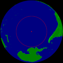
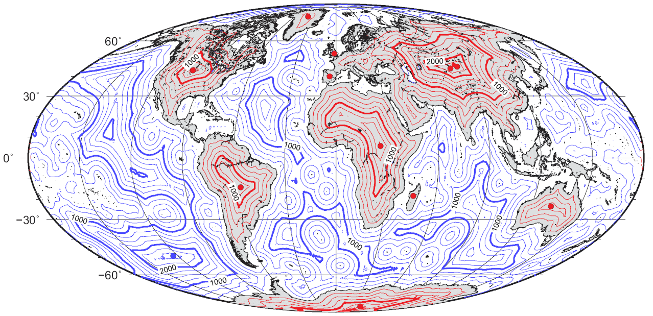
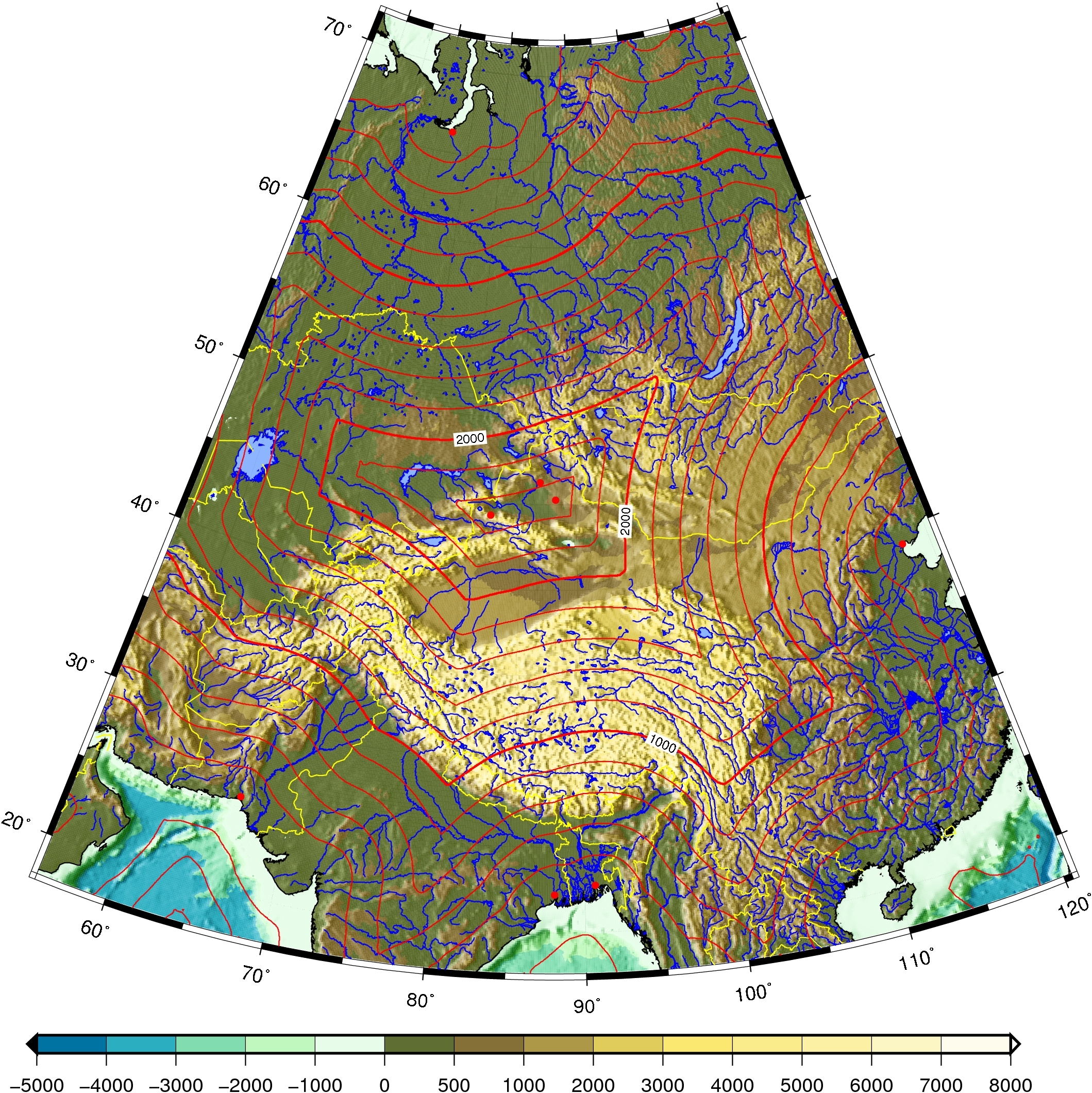
 Map of distance to the nearest coastline (including oceanic islands, but not lakes) with red spots marking the poles of inaccessibility of main land masses, Britain, and the Iberian Peninsula. Thin isolines are 250 km apart; thick lines 1000 km. Mollweide projection.
A pole of inaccessibility marks a location that is the most challenging to reach owing to its remoteness from geographical features that could provide access. The term describes a geographic construct, not an actual physical phenomenon, and is of interest mostly to explorers.
Contents
Northern pole of inaccessibility
 Northern pole of inaccessibility
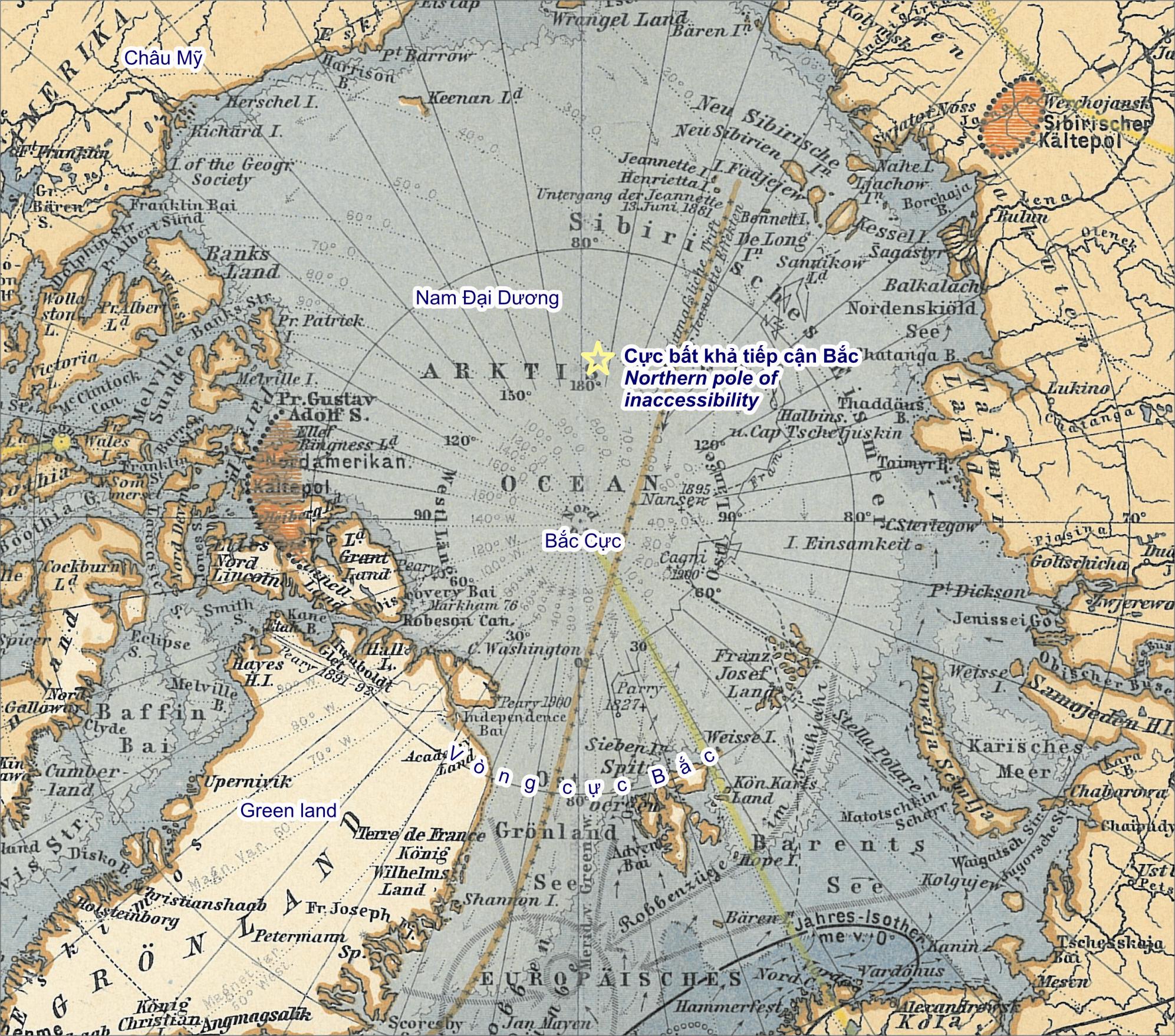
The northern pole of inaccessibility (84°03′N 174°51′W / 84.05°N 174.85°W), sometimes known as the Arctic pole of inaccessibility, or just Arctic pole, is located on the Arctic Ocean pack ice at a distance farthest from any land mass. It is 661 km (411 statute miles) from the North Pole, 1,453 km (903 mi) north of Barrow, Alaska, and equidistant from the closest landmasses, Ellesmere Island and Franz-Josef Land, 1,094 km (680 mi) away.[further explanation needed] It was first crossed by Sir Hubert Wilkins, who flew by aircraft in 1927; in 1958, a Russian icebreaker reached this point.[citation needed] Owing to the constant motion of the pack ice, no permanent structure can exist at the pole.
According to some reports, the first person to reach the spot on foot was Sir Wally Herbert, who arrived by dogsled in 1968. Other reports speak of this Pole as being still unconquered as of explorer Jim McNeill's unsuccessful attempt in 2006.[1] According to McNeill, Herbert did not quite make the Pole, whose position has also now been more accurately determined.[2]
Southern pole of inaccessibility
 Southern pole of inaccessibility
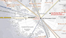
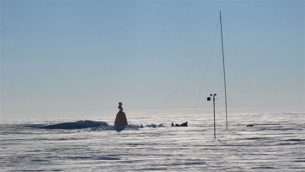
 The old Soviet Pole of Inaccessibility Station, revisited by Team N2i on 19 January 2007
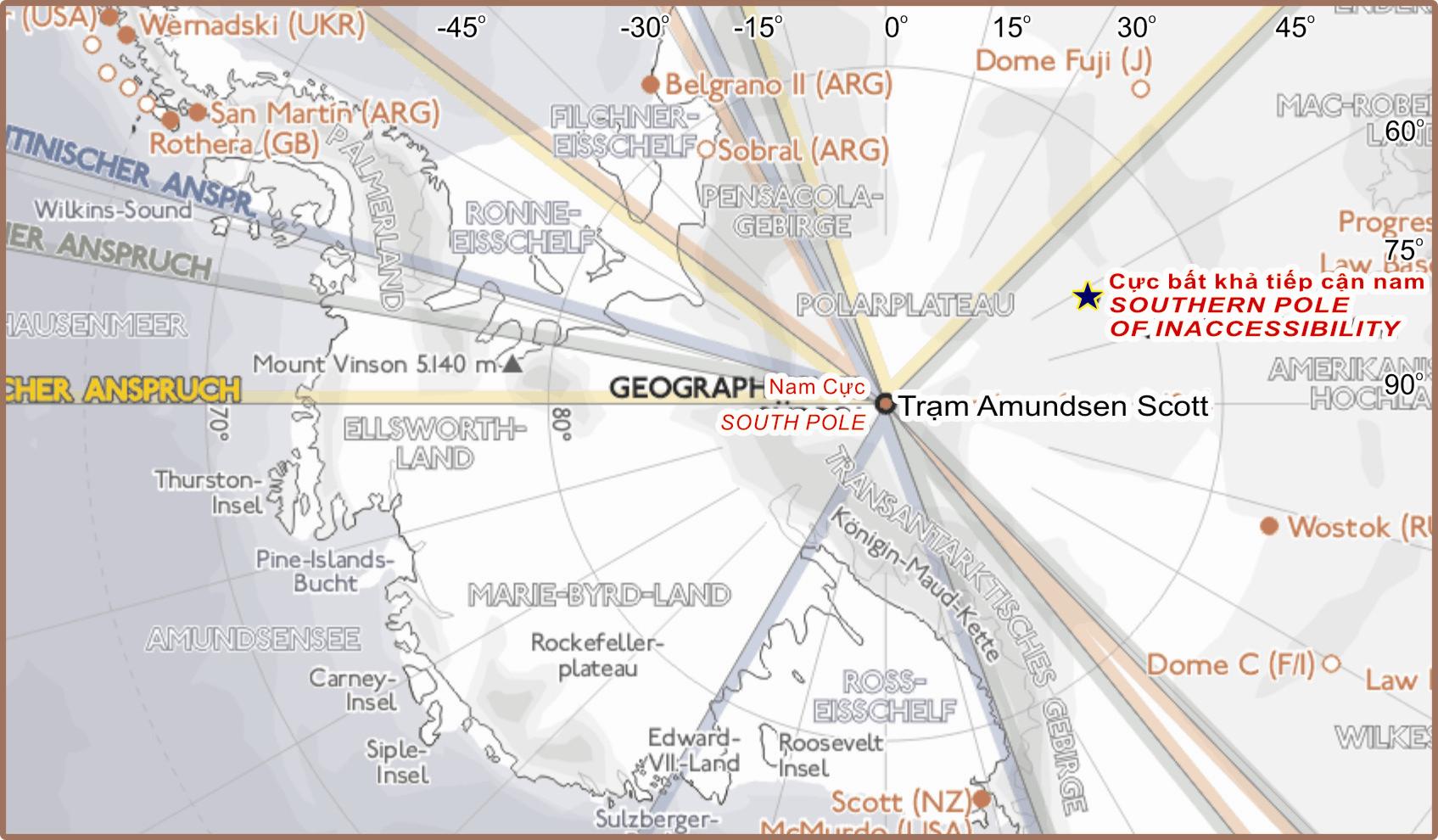
The southern pole of inaccessibility is the point on the Antarctic continent most distant from the Southern Ocean. A variety of different coordinate locations have been given for this pole. The discrepancies are due to the question of whether the "coast" is measured to the grounding line or to the edges of ice shelves, the difficulty of determining the location of the "solid" coastline, the movement of ice sheets and improvements in the accuracy of survey data over the years, as well as possible typographical errors. The pole of inaccessibility is commonly referred to the site of the Soviet Union research station mentioned below, which lies at 82°06′S 54°58′E / 82.1°S 54.967°E[3] (though some sources give 83°06′S 54°58′E / 83.1°S 54.967°E[4]). This lies 878 km (545 statute miles) from the South Pole, at an elevation of 3,718 m (12,198 ft). Using different criteria, the Scott Polar Research Institute locates the pole at 85°50′S 65°47′E / 85.833°S 65.783°E.[5]
According to ThePoles.com, the point farthest from the sea accounting only for the Antarctic land surface proper is at 82°53′14″S 55°4′30″E / 82.88722°S 55.075°E, and the farthest point when ice sheets are taken into account is 83°50′37″S 65°43′30″E / 83.84361°S 65.725°E. These points, calculated by the British Antarctic Survey, are quoted as being "the most accurate measure available" (as of 2005).[6]
The southern pole of inaccessibility is far more remote and difficult to reach than the geographic South Pole. On 14 December 1958, the 3rd Soviet Antarctic Expedition for International Geophysical Year research work, led by Yevgeny Tolstikov, established the temporary Pole of Inaccessibility Station (Polyus Nedostupnosti) at 82°06′S 54°58′E / 82.1°S 54.967°E. A second Russian team returned there in 1967. Today, a building still remains at this location, marked by a bust of Vladimir Lenin that faces towards Moscow, and protected as a historical site. Inside the building, there is a golden visitors' book for those who make it to the site to sign.
On December 4, 2006, Team N2i, consisting of Henry Cookson, Rupert Longsdon, Rory Sweet and Paul Landry, embarked on an expedition to be the first to reach the historic pole of inaccessibility location without direct mechanical assistance, using a combination of traditional man hauling and kite skiing. The team reached the old abandoned station on 20 January 2007, re-discovering the forgotten statue of Lenin left there by the Soviets some 48 years previously. The explorers were picked up from the spot by a plane from Vostok base to Progress and taken back to Cape Town on the Academic Federov, a Russian icebreaker.[7] However, as of 2007, only the bust on top of the building is visible; the rest is buried under the snow.[8]
On December 11, 2005, at 7:57 UTC, Ramón Larramendi, Juan Manuel Viu, and Ignacio Oficialdegui, members of the Spanish Transantarctic Expedition, reached for the first time in history the southern pole of inaccessibility at 82°53′14″S 55°04′30″E / 82.88722°S 55.075°E, updated that year by the British Antarctic Survey. The team continued their journey towards the second southern pole of inaccessibility, the one that accounts the ice shelves as well as the continental land, and they were the first expedition to reach it, on December 14, 2005, at 83°50′37″S 65°43′30″E / 83.84361°S 65.725°E. Both achievements took place within an ambitious pioneer crossing of the eastern Antarctic Plateau that started at Novolazerevskaya Base and ended at Progress Base after more than 4,500 km. This was the fastest polar journey ever achieved without mechanical aid, with an average rate of around 90 km/day and maximum 311 km/day, using kites as power source..[9][10][11][12]
As mentioned above, due to improvements in technology and the position of the continental edge of Antarctica being debated, the exact position of our best estimate of the pole of inaccessibility may alter. However, for the convenience of sport expeditions, a fixed point is preferred, and the Soviet station has been used for this role. This has been recognised by the Guinness Book of Records in regard to Team N2i's expedition in 2006–2007.[13]
Oceanic pole of inaccessibility
 Oceanic pole of inaccessibility at 48° 52′ 36″S 123° 23′ 36″W
The oceanic pole of inaccessibility (48°52.6′S 123°23.6′W / 48.8767°S 123.3933°W) is the place in the ocean that is farthest from land. It lies in the South Pacific Ocean, 2,688 kilometres (1,670 mi) from the nearest lands: Ducie Island (part of the Pitcairn Islands) in the north, Motu Nui (part of the Easter Islands) in the northeast, and Maher Island (near the larger Siple Island, off the coast of Marie Byrd Land, Antarctica) in the south. Chatham Island lies farther west, and Southern Chile in the east. This location is also referred to as "Point Nemo", a reference to Jules Verne's Captain Nemo.[14]
Continental pole of inaccessibility
Eurasia
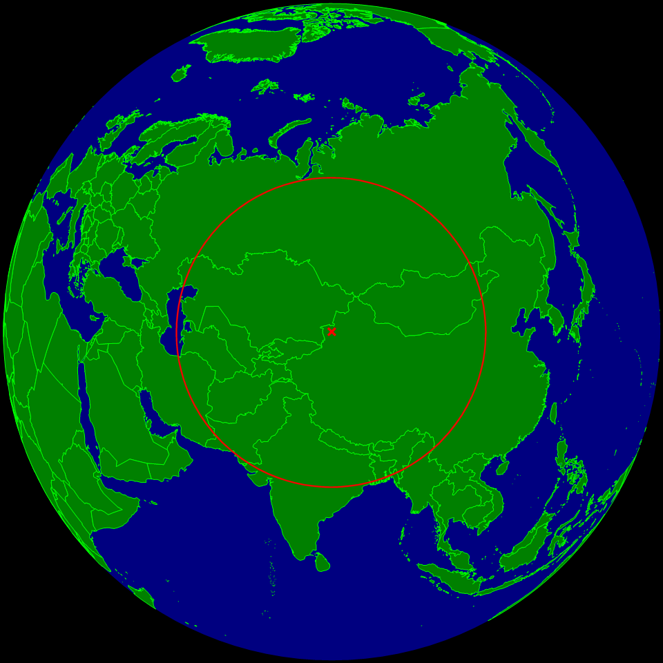
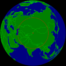 Continental pole of inaccessibility EPIA1
 Location map of the pole of inaccessibility (PIA) of Eurasia
The Continental Pole of Inaccessibility (46°17′N 86°40′E / 46.283°N 86.667°E) is the place on land that is farthest from the ocean, and it lies in north-western China, near the Kazakhstan border. Earlier calculations suggested that it is 2,645 km (1,644 mi) from the nearest coastline, located approximately 320 km (200 mi) north of the city of Ürümqi, in the Xinjiang Autonomous Region of China, in the Dzoosotoyn Elisen Desert. The nearest settlements to this location are Hoxtolgay at 46°34′N 85°58′E / 46.567°N 85.967°E, about 30 miles (48 km) to the northwest, Xazgat at 46°20′N 86°22′E / 46.333°N 86.367°E about 13 miles (21 km) to the west, and Suluk at 46°15′N 86°50′E / 46.25°N 86.833°E about 7 miles (11 km) to the east.[15]
However, the previous pole location disregards the Gulf of Ob as part of the oceans, and a recent study[16] proposes two other locations as the ones farther from any ocean (within the uncertainty of coastline definition): EPIA1 44°17′N 82°11′E / 44.29°N 82.19°E and EPIA2 45°17′N 88°08′E / 45.28°N 88.14°E, located respectively at 2510±10 km and 2514±7 km from the oceans.[16]
Coincidentally, the continental and oceanic poles of inaccessibility have a similar radius; the Eurasian poles EPIA1 and EPIA2 are ~178 km closer to the ocean than the oceanic pole is to land.
North America
In North America, the continental pole of inaccessibility is in southwest South Dakota between Kyle and Allen, located 1,650 km (1,030 mi) from the nearest coastline at 43°22′N 101°58′W / 43.36°N 101.97°W.[16]
South America
In South America, the continental pole of inaccessibility is in Brazil at 14°03′S 56°51′W / 14.05°S 56.85°W, near Arenápolis.[16]
Australia
In Australia, the continental pole of inaccessibility is located either at 23°10′S 132°16′E / 23.17°S 132.27°E[16] or at 23°2′S 132°10′E / 23.033°S 132.167°E,[17] 920 km (570 mi) from the nearest coastline. The nearest town is Papunya, Northern Territory, about 30 km to the southwest.
Africa
In Africa, the pole of inaccessibility is at 5°39′N 26°10′E / 5.65°N 26.17°E, 1,814 km (1,127 mi) from the coast,[16] close to the tripoint of Central African Republic, South Sudan and Democratic Republic of the Congo, also close to the town of Obo.
See also
- Pole of inaccessibility (Antarctic research station)
- Geographical pole
- Extreme points of Earth
- Distance transform
References
- ^ http://news.bbc.co.uk/1/hi/sci/tech/4731672.stm
- ^ http://theadventureblog.blogspot.com/2010/02/north-pole-2010-expedition-to-pole-of.html
- ^ Catalogue of Russian Antarctic Meteorological data 1994, World Meteorological Organization, retrieved June 2007
- ^ Historic Sites & Monuments in Antarctica, International Polar Heritage Committee
- ^ Polar Information Sheets, Scott Polar Research Institute, retrieved June 2007
- ^ "Spaniards reach the 'second' South Pole of Inaccessibility - still no trace of Lenin", ThePoles.com, December 15, 2005, retrieved June 2007
- ^ "UK team makes polar trek history", BBC news story, retrieved June 2007
- ^ team n2i website uploaded jan 2007
- ^ http://www.thepoles.com/news.php?id=1276
- ^ http://www.barrabes.com/revista/articulo_ant.asp?idArticulo=4549
- ^ http://www.tierraspolares.es/catamaran/inaccesibilidad_i.htm
- ^ http://www.thepoles.com/news.php?id=1298
- ^ http://www.teamn2i.com/media/files/guinness_book_records_team_n2i_antarctic_ec1.jpg
- ^ Hrvoje Lukatela, Point Nemo (or, One Thousand and Four Hundred Miles from Anywhere)
- ^ [1] Map of the region around the Continental Pole of Inaccessibility, showing relative locations of Hoxtolgay, Xazgat and Suluk, from MSN Maps.
- ^ a b c d e f Garcia-Castellanos, D.; U. Lombardo (2007). "Poles of Inaccessibility: A Calculation Algorithm for the Remotest Places on Earth". Scottish Geographical Journal 123 (3): 227–233. doi:10.1080/14702540801897809. http://cuba.ija.csic.es/~danielgc/papers/Garcia-Castellanos,%20Lombardo,%202007,%20SGJ.pdf. Retrieved 2008.
- ^ Centre of Australia, States and Territories, Geoscience Australia
External links
Categories:- Poles
- Geography of the Arctic

Wikimedia Foundation. 2010.