- Northern Sea Route
-
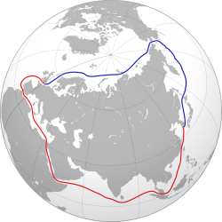 A graphical comparison between the North East Passage (blue) and an alternative route through Suez Canal (red)
The Northern Sea Route (Russian: Се́верный морско́й путь, Severnyy morskoy put’, shortened to Sevmorput' ) is a shipping lane officially defined by Russian legislation from the Atlantic Ocean to the Pacific Ocean specifically running along the Russian Arctic coast from Murmansk on the Barents Sea, along Siberia, to the Bering Strait and Far East. The entire route lies in Arctic waters and parts are free of ice for only two months per year. Before the beginning of the 20th century it was known as the Northeast Passage, and is still sometimes referred to by that name.
Contents
History
The motivation to navigate the North East Passage was initially economic. In Russia the idea of a possible seaway connecting the Atlantic and the Pacific was first put forward by the diplomat Gerasimov in 1525. However, Russian settlers and traders on the coast of the White Sea, the Pomors, had been exploring parts of the route as early as the 11th century.
During a voyage across the Barents Sea in search of the North East Passage in 1553, English explorer Hugh Willoughby thought he saw islands to the north, and islands called Willoughby's Land were shown on maps published by Plancius and Mercator in the 1590s and they continued to appear on maps by Jan Janssonius and Willem Blaeu into the 1640s.[1]
By the 17th century, traders had established a continuous sea route from Arkhangelsk to the Yamal Peninsula, where they portaged to the Gulf of Ob. This route, known as the "Mangazeya seaway", after its eastern terminus, the trade depot of Mangazeya, was an early precursor to the Northern Sea Route.
East of the Yamal, the route north of the Taimyr Peninsula proved impossible or impractical. East of the Taimyr, from the 1630s, Russians began to sail the Arctic coast from the mouth of the Lena River to a point beyond the mouth of the Kolyma River. Both Vitus Bering (in 1728) and James Cook (n 1778) entered the Bering Strait from the south and sailed some distance northwest, but from 1648 (Semyon Dezhnev) to 1879 (Adolf Erik Nordenskiöld) no one is recorded as having sailed eastward between the Kolyma and Bering Strait.
The western parts of the passage were explored by northern European countries such as England, the Netherlands, Denmark, and Norway, looking for an alternative seaway to China and India. Although these expeditions failed, new coasts and islands were discovered. The most notable was the 1596 expedition led by Dutch navigator Willem Barentsz, who discovered Spitsbergen and Bear Island and rounded the north of Novaya Zemlya.
Fearing English and Dutch penetration into Siberia, Russia closed the Mangazeya seaway in 1619. Pomor activity in Northern Asia declined and the bulk of exploration in the 17th century was carried out by Siberian Cossacks, sailing from one river mouth to another in their Arctic-worthy kochs. In 1648 the most famous of these expeditions, led by Fedot Alekseev and Semyon Dezhnev, sailed east from the mouth of the Kolyma to the Pacific and rounded the Chukchi Peninsula, thus proving that no land connection between Asia and North America exists.
Eighty years after Dezhnev, in 1728, another Russian explorer, Danish-born Vitus Bering on Svyatoy Gavriil (Saint Gabriel) made a similar voyage in reverse, starting in Kamchatka and going north to the passage that now bears his name (Bering Strait).[2] It was Bering who gave their current names to Diomede Islands, vaguely mentioned by Dezhnev.
Bering's explorations of 1725–30 were part of a larger scheme initially devised by Peter the Great and known as the "Great Northern Expedition".
The "Second Kamchatka Expedition" took place in 1735–42. This time there were two ships, Svyatoy Pyotr and Svyatoy Pavel, the latter commanded by Bering's deputy in the first expedition, Captain Aleksey Chirikov. During the Second Expedition Bering became the first Westerner to sight the coast of north-western North America, and Chirikov the first to land there. (A storm had separated the two ships earlier.) On his way back Bering discovered the Aleutian Islands but fell ill, and Svyatoy Pyotr had to take shelter on an island off Kamchatka, where Bering died (Bering Island).
Independent of Bering and Chirikov, other Russian Imperial Navy parties took part in the Second Great Northern Expedition. One of these, led by Semyon Chelyuskin, in May 1742 reached Cape Chelyuskin, the northernmost point of both the North East Passage and the Eurasian continent.
Later expeditions to explore the North East Passage took place in the 1760s (Vasiliy Chichagov), 1785–95 (Joseph Billings and Gavril Sarychev), the 1820s and 1830s (Ferdinand Petrovich Wrangel, Pyotr Fyodorovich Anjou, Count Fyodor Litke and others). The possibility of navigation of the whole length of the passage was proved by the mid-19th century.
However, it was only in 1878 that Finnish-Swedish explorer Nordenskiöld made the first complete passage of the North East Passage from west to east, in the Vega expedition. The ship's captain on this expedition was Lieutenant Louis Palander of the Swedish Royal Navy.
One year before Nordenskiöld's voyage, commercial exploitation of a section of the route started with the so-called Kara expeditions, exporting Siberian agricultural produce via the Kara Sea. Of 122 convoys between 1877 and 1919 only 75 succeeded, transporting as little as 55 tons of cargo. From 1911 the "Kolyma steamboats" ran from Vladivostok to the Kolyma once a year.
In 1912 two Russian expeditions set out; Captain Georgy Brusilov and the Brusilov Expedition in the Santa Anna, and Captain Alexander Kuchin with Vladimir Rusanov in the Gerkules; each with a woman on board. Both expeditions were hastily arranged, and both disappeared.
In 1915 a Russian expedition led by Boris Vilkitskiy made the passage from east to west with the icebreakers Taymyr and Vaygach.[3]
Nordenskiöld, Nansen, Amundsen, DeLong, Makarov and others also led expeditions; mainly for scientific and cartographic purposes.
After the Russian Revolution
The introduction of radio, steamboats and icebreakers made running the Northern Sea Route viable. After the Russian Revolution of 1917, the Soviet Union was isolated from the western powers, which made it imperative to use this route. Besides being the shortest seaway between the western and far eastern USSR, it was the only one which lay inside Soviet internal waters and did not impinge upon those which belonged to nearby opposing countries.
In 1932 a Soviet expedition led by Professor Otto Yulievich Schmidt was the first to sail all the way from Arkhangelsk to the Bering Strait in the same summer without wintering en route. After a couple more trial runs, in 1933 and 1934, the "Northern Sea Route" was officially defined and open and commercial exploitation began in 1935. The next year, part of the Baltic Fleet made the passage to the Pacific where armed conflict with Japan was looming.
A special governing body Glavsevmorput (Chief Directorate of the Northern Sea Route) was set up in 1932, and Otto Schmidt became its first director. It supervised navigation and built Arctic ports.
During the early part of World War II, the Soviets allowed the German auxiliary cruiser Komet to use the Northern Sea Route in the summer of 1940 to evade the British Royal Navy and break out into the Pacific Ocean. Komet was escorted by Soviet icebreakers during her journey. After the start of the Soviet-German War the Soviets transferred several destroyers from the Pacific Fleet to the Northern Fleet via the Arctic. The Soviets also used the Northern Sea Route to transfer materials from the Soviet Far East to European Russia and the Germans launched Operation Wunderland in order to interdict this traffic.
After the breakup of the Soviet Union in the early 1990s, commercial navigation in the Siberian Arctic went into decline. More or less regular shipping is to be found only from Murmansk to Dudinka in the west and between Vladivostok and Pevek in the east. Ports between Dudinka and Pevek see virtually no shipping. Logashkino and Nordvik were abandoned and are now ghost towns[citation needed].
Renewed interest led to several demonstration voyages in 1997[4] including the passage of M/T Uikku.[5]
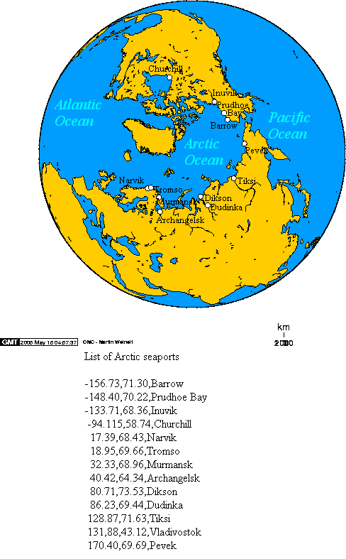
Ice-free ports
 Arctic Ocean seaports.
Several seaports along the route are ice-free all year round. They are, west to east, Murmansk on the Kola Peninsula, and on Russia's Pacific seaboard Petropavlovsk in Kamchatka, Vanino, Nakhodka, and Vladivostok. Arctic ports are generally usable July to October, or, such as Dudinka, are served by nuclear powered icebreakers.
 Nuclear icebreaker NS 50 Let Pobedy escorting the Beluga Fraternity and Beluga Foresight through the Northern Sea Route in the summer of 2009.
French sailor Eric Brossier made the first passage by sailboat in only one season in the summer of 2002.[7] He returned to Europe the following summer by the Northwest Passage.
The Northern Sea Route was opened by receding ice in 2005 but was closed by 2007. The amount of polar ice had receded to 2005 levels in August 2008. In late August 2008, it was reported that images from the NASA Aqua satellite had revealed that the last ice blockage of the Northern Sea Route in the Laptev Sea had melted. This would have been the first time since satellite records began that both the Northwest Passage and Northern Sea Route had been open simultaneously.[8] However, other scientists suggested that the satellite images may have been misread and that the sea route was not yet passable.[9]
The Bremen-based Beluga Group claimed in 2009 to be the first Western company to attempt to cross the Northern Sea Route for shipping without assistance from icebreakers, cutting 4000 nautical miles off the journey between Ulsan, Korea and Rotterdam.[8][10]
However, the new (2008) ice-strengthened heavy lift vessels Beluga Fraternity and Beluga Foresight commenced an East-to-West passage of the Northern Sea Route in August 2009 [9][11] as part of a small convoy escorted by the Russian nuclear icebreaker NS 50 Let Pobedy, westward through the Bering, Sannikov, and Vilkitskiy Straits. The two vessels embarked Russian ice pilots for the voyage to the western Siberian port of Novyy, in the Yamburg region in the delta of the Ob River. The ships arrived at Novvy on 7 September, discharged their cargo to barges and departed on 12 September, bound for the Kara Gates and Rotterdam.
They were the first non-Russian commercial vessels to complete this journey, but not without Russian assistance.[12] The captain of the Beluga Foresight, Valeriy Durov, described the achievement as "great news for our industry".[12]
The president of Beluga Shipping claimed the voyage saved each vessel about 300,000 euros, compared to the normal Korea-to-Rotterdam route by way of the Suez Canal. The company did not disclose how much they paid for the escort service and the Russian pilots. An 18 September 2009 press release stated that the company is already planning for six vessels to make Arctic deliveries in 2010.[13]
In September 2010, two yachts completed circumnavigation of the Arctic: Børge Ousland's team aboard "The Northern Passage" [3], and Sergei Murzayev's team in the "Peter I". These were the first recorded instances of the circumnavigation of the Arctic by sailing yachts in one season.
In 2009, the first two international commercial cargo vessels traveled north of Russia between Europe and Asia[14]. In 2011, 18 ships have made the now mostly ice-free crossing[15].
Commercial value
The gains from shipping operations on an ice-free Northern Sea Route appear to be reduced number of days at sea and more than doubling of the vessel fuel efficiency if shipping from northern European to northern Pacific ports. For the corporate players in bulk shipping of relative low value raw materials, cost savings for fuel may appear as a driver to explore the Northern Sea Route for commercial transits, and not necessarily reduced lead time. The Northern Sea Route coastal route alternatives, with vessel draught and beam limitation, are a hindrance for large vessels, and therefore achieve the same economies of scale in shipping as via the Suez Canal. Environmental demands faced by the maritime shipping industry may emerge as one of the drivers for developing the Northern Sea Route. Increased knowledge about environmental benefits and costs for both the Northern Sea Route and Suez routes will probably be important factors in this respect. [16]
Commemoration
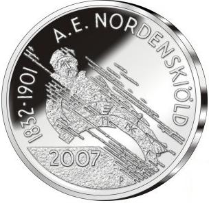
In 2007, Finland issued a €10 Adolf Erik Nordenskiöld and Northeast Passage commemorative coin. This issue celebrates the 175th anniversary of Nordenskiöld's birth and his discovery of the Northern Sea Route. The obverse features an abstract portrait of Nordenskiöld at the helm of his ship. The reverse is dominated by a pattern resembling the labyrinth formed by adjacent ice floes.
The coin is one of the Europa Coins 2007 series, which celebrates European achievements in history.
See also
- Great Northern Expedition
- Northwest Passage
- Arctic Bridge
- Arctic policy of Russia
- Territorial claims in the Arctic
- List of Russian explorers
References
- ^ Hacquebord, Louwrens (Sept 1995). "In Search of Het Behouden Huys: A Survey of the Remains of the House of Willem Barentsz on Novaya Zemlya". Arctic 48 (3): 250. http://pubs.aina.ucalgary.ca/arctic/Arctic48-3-248.pdf. Retrieved 2009-03-08.
- ^ Vaughan, Richard (2007). The Arctic: A History. Stroud: A. Sutton.
- ^ Barr, William (1975). "A Tsarist Attempt at Opening the Northern Sea Route: The Arctic Oeean Hydrographie Expedition, 1910-1915". Polarforschung. http://epic.awi.de/Publications/Polarforsch1975_1_6.pdf. Retrieved 2010-08-23.
- ^ Lawson W. Brigham: "The Northern Sea Route, 1997" in Polar Record (1998), 34 : 219-224 Cambridge University Press doi:10.1017/S0032247400025687
- ^ The M/T Uikku navigated the entire Northern Sea Route in 1997
- ^ Revkin, Andrew (September 6, 2008). "Experts Confirm Open Water Circling Arctic". New York Times. http://dotearth.blogs.nytimes.com/2008/09/06/confirmation-of-open-water-circling-north-pole/. Retrieved 2009-10-03.
- ^ "Eric Brossier, le vagabond des pôles" (in French). July 2004. http://www.linternaute.com/voyager/interview/eric-brossier/eric-brossier.shtml. Retrieved 2009-09-21.
- ^ a b "Space Radar Helps Shipping Dodge Arctic Icebergs". National Geographic. December 2, 2008. http://blogs.nationalgeographic.com/blogs/news/chiefeditor/2008/12/space-radar-helps-shipping-dod.html. Retrieved 2009-10-03.
- ^ a b Andrew Revkin (2009-09-04). "Commercial Arctic Passage Nearing Goal". New York Times. http://dotearth.blogs.nytimes.com/2009/09/04/commercial-arctic-passage-nearing-goal/. Retrieved 2009-09-05.
- ^ "German vessels ready for the Northern Sea Route". BarentsObserver.com. 2009-08-05. http://www.barentsobserver.com/german-vessels-ready-for-the-northern-sea-route.4616626-16175.html. Retrieved 2009-09-21.
- ^ "German commercial ships make historic Arctic journey". Deutsche Welle. 2009-09-12. http://www.dw-world.de/dw/article/0,,4679955,00.html. Retrieved 2009-09-21.
- ^ a b "Arctic trail blazers make history". BBC. 2009-09-19. http://news.bbc.co.uk/2/hi/europe/8264345.stm. Retrieved 2009-09-21.
- ^ http://www.beluga-group.com/en/#News-News
- ^ [1]
- ^ [2]
- ^ Schøyen, H., & Bråthen, S. (2011) The Northern Sea Route versus the Suez Canal: cases from bulk shipping. Journal of Transport Geography, 19(4), 977-983
External links
- International Northern Sea Route Programme]
- Russian State Museum of the Arctic and Antarctic, The discovery and history of exploration of the Northern Sea Route
- Pictures - during NE passage
- Tanker Vladimir Tikhonov Completes Successful Northern Sea Route Transit in a Week
- Armstrong, Terence. The Northern Sea Route (Cambridge: Cambridge University Press, 1952)
- Belov, M. I. Istoriia otkrytiia i osveniia Severnogo Morskogo Puti, 4 vols. (Leningrad, 1956–1969)
- Horensma, Piers. The Soviet Arctic (London: Routledge, 1991)
- McCannon, John. Red Arctic (New York: Oxford University Press, 1998)
Categories:- Geography of Russia
- Water transport in Russia
- Navigation
- Shipping routes
- Polar exploration by Russia and the Soviet Union
- Soviet Union–United States relations
- Canada–Soviet Union relations
- Kara Sea
- East Siberian Sea
- Laptev Sea
- Chukchi Sea
- Transport in the Arctic
- Arctic Ocean

Wikimedia Foundation. 2010.