- Kamchatka Oblast
Infobox Russian federal subject
EnglishName=Kamchatka Oblast
RussianName=Камчатская область
Locator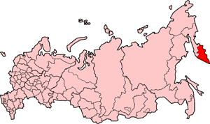
LocatorMap
CoatOfArmsLink=Coat of arms of Kamchatka Oblast 
FlagLink=Flag of Kamchatka Oblast
AnthemLink=Anthem of Kamchatka Oblast
AdmCtrOrCapital=Administrative center
AdmCtrName=Petropavlovsk-Kamchatsky
FoundationDate=October 20 ,1932
PoliticalStatus=Oblast
PoliticalStatusLink=Oblasts of Russia
FederalDistrict=Far Eastern
EconomicRegion= Far Eastern
CodeNumber=41
Area=472300
AreaRank=10th
Population=358801
PopulationRank=76th
UrbanPopulation=81.1%
RuralPopulation=18.9%
LangLangs
LangList=Russian
HeadTitle=Governor "(acting)"
HeadName=Alexey Kuzmitsky
PrimeTitle
PrimeName
Legislature=Council of People's Deputies
ConstitutionType=Charter
ConstitutionName=Charter of Kamchatka Oblast
Website=http://www.ako.kamchatka.ru/Kamchatka Oblast ( _ru. Камча́тская о́бласть, "Kamchatskaya oblast") was (until being incorporated into
Kamchatka Krai on July 1, 2007) a federal subject ofRussia (anoblast ). To the north, it borderedMagadan Oblast andChukotka Autonomous Okrug .Koryak Autonomous Okrug was located in the northern part of the oblast. Including Koryakia, the total area of the oblast was 472,300 km², encompassing the southern half of theKamchatka Peninsula .The climate is cold and humid.Kamchatka's natural resources include
coal ,gold ,mica ,pyrite s, andnatural gas . Most of the inhabitants live in the administrative center,Petropavlovsk-Kamchatsky . The main employment sectors arefishing ,forestry ,tourism (a growing industry), and the Russian military. There is still a large military presence on the peninsula; the home base of Russia's Pacificsubmarine fleet is acrossAvacha Bay fromPetropavlovsk-Kamchatsky at the Rybachy base. There are also several air force bases and radar sites in Kamchatka.As of the 2002 All-Russian Population Census, the majority of the 358,801 population is Russian (290,108), largest minorities are Ukrainian (20,870) and Koryak (7,328). The northern part of the peninsula is occupied by
Koryak Autonomous Okrug , where around 6,700Koryaks live. A small number ofEvens also live here.Geography
Time zone
Kamchatka Oblast is located in the Kamchatka Time Zone (PETT/PETST). UTC offset is +1200 (PETT)/+1300 (PETST).
Administrative divisions
External links
*en icon [http://www.kamchatkapeninsula.com The Wonders of Kamchatka]
*ru icon [http://www.beringisland.ru Commander Islands]


Wikimedia Foundation. 2010.