- Chukchi Peninsula
-
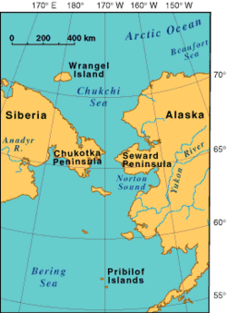
The Chukchi Peninsula, Chukotka Peninsula or Chukotski Peninsula (Russian: Чуко́тский полуо́стров, Russian: Чуко́тка), at about 66° N 172° W, is the northeastern extremity of Asia. Its eastern end is at Cape Dezhnev near the village of Uelen. It is bordered by the Chukchi Sea to the north, the Bering Sea to the south, and the Bering Strait to the east. The peninsula is part of Chukotka Autonomous Okrug of Russia. The estimated population of the region in 1990 was 155,000.[1]
The peninsula was traditionally the home of the native Chukchi people, some Eskimo peoples (Siberian Yupiks and Sireniki Eskimos), Koryaks, Chuvans, Evens/Lamuts, Yukagirs, and some Russian settlers.
The peninsula lies along the Northern Sea Route (the Northeast passage).
Industries on the peninsula are mining (tin, lead, zinc, gold, and coal), hunting and trapping, reindeer raising, and fishing. See also Providence Bay, Siberia.
References
- ^ "Chukchi Peninsula". Encyclopedia.com. Accessed September 2010.
Further reading
- Aĭnana, L., and Richard L. Bland. Umiak the traditional skin boat of the coast dwellers of the Chukchi Peninsula : compiled in the communities of Provideniya and Sireniki, Chukotka Autonomous Region, Russia 1997-2000. Anchorage: U.S. Dept. of the Interior, National Park Service, 2003.
- Dinesman, Lev Georgievich. Secular dynamics of coastal zone ecosystems of the northeastern Chukchi Peninsula Chukotka : cultural layers and natural depositions from the last millennia. Tübingen [Germany]: Mo Vince, 1999. ISBN 3934400035
- Dikov, Nikolaĭ Nikolaevich. Asia at the Juncture with America in Antiquity The Stone Age of the Chukchi Peninsula. St. Petersburg: "Nauka", 1993.
- Frazier, Ian, Travels in Siberia, Farrar, Straus, and Giroux, 2010. Best travelogue on Siberia in a long time.
- Portenko, L. A., and Douglas Siegel-Causey. Birds of the Chukchi Peninsula and Wrangel Island = Ptitsy Chukotskogo Poluostrova I Ostrova Vrangelya. New Delhi: Published for the Smithsonian Institution and the National Science Foundation, Washington, D.C., by Amerind, 1981.
Coordinates: 66°00′N 172°00′W / 66°N 172°W

This Chukotka Autonomous Okrug location article is a stub. You can help Wikipedia by expanding it.


