- Chukotka Autonomous Okrug
-
Chukotka Autonomous Okrug Чукотский автономный округ (Russian) — Autonomous okrug — 
Flag
Coat of arms
Coordinates: 66°40′N 171°00′E / 66.667°N 171°ECoordinates: 66°40′N 171°00′E / 66.667°N 171°E Political status Country Russia Federal district Far Eastern[1] Economic region Far Eastern[2] Established 1930 Administrative center Anadyr Government (as of March 2011) - Governor Roman Kopin[3] - Legislature Duma Statistics Area (as of the 2002 Census)[4] - Total 737,700 km2 (284,827.6 sq mi) Area rank 7th Population (2010 Census)[5] - Total 50,500 - Rank 82nd - Density 0.07 /km2 (0.18 /sq mi) - Urban 67.6% - Rural 32.4% Population (2002 Census)[6] - Total 53,824 - Rank 82nd - Density 0.07 /km2 (0.18 /sq mi) - Urban 66.6% - Rural 33.4% Time zone(s) MAGST (UTC+12:00)[7] ISO 3166-2 RU-CHU License plates 87 Official languages Russian[8] http://www.chukotka.org/ Chukotka Autonomous Okrug (Russian: Чуко́тский автоно́мный о́круг, Chukotsky avtonomny okrug; Chukchi: Чукоткакэн автономныкэн округ, Chukotkaken avtonomnyken okrug), or Chukotka (Чуко́тка), is a federal subject of Russia (an autonomous okrug) located in the Russian Far East.
Chukotka has a population of 53,824 according to the 2002 Census, and a surface area of 737,700 km2 (284,800 sq mi). The principal town and the administrative center is Anadyr. Chukotka AO is the most northeasterly region of Russia and, since the sale of Alaska to the United States, has been the only part of Russia lying partially in the Western Hemisphere (east of the 180th meridian).
Lake El'gygytgyn, an important site for scientific research on climate change, is located in Chukotka, as is the village of Uelen, the closest substantial Russian settlement to the United States.
Contents
Geography
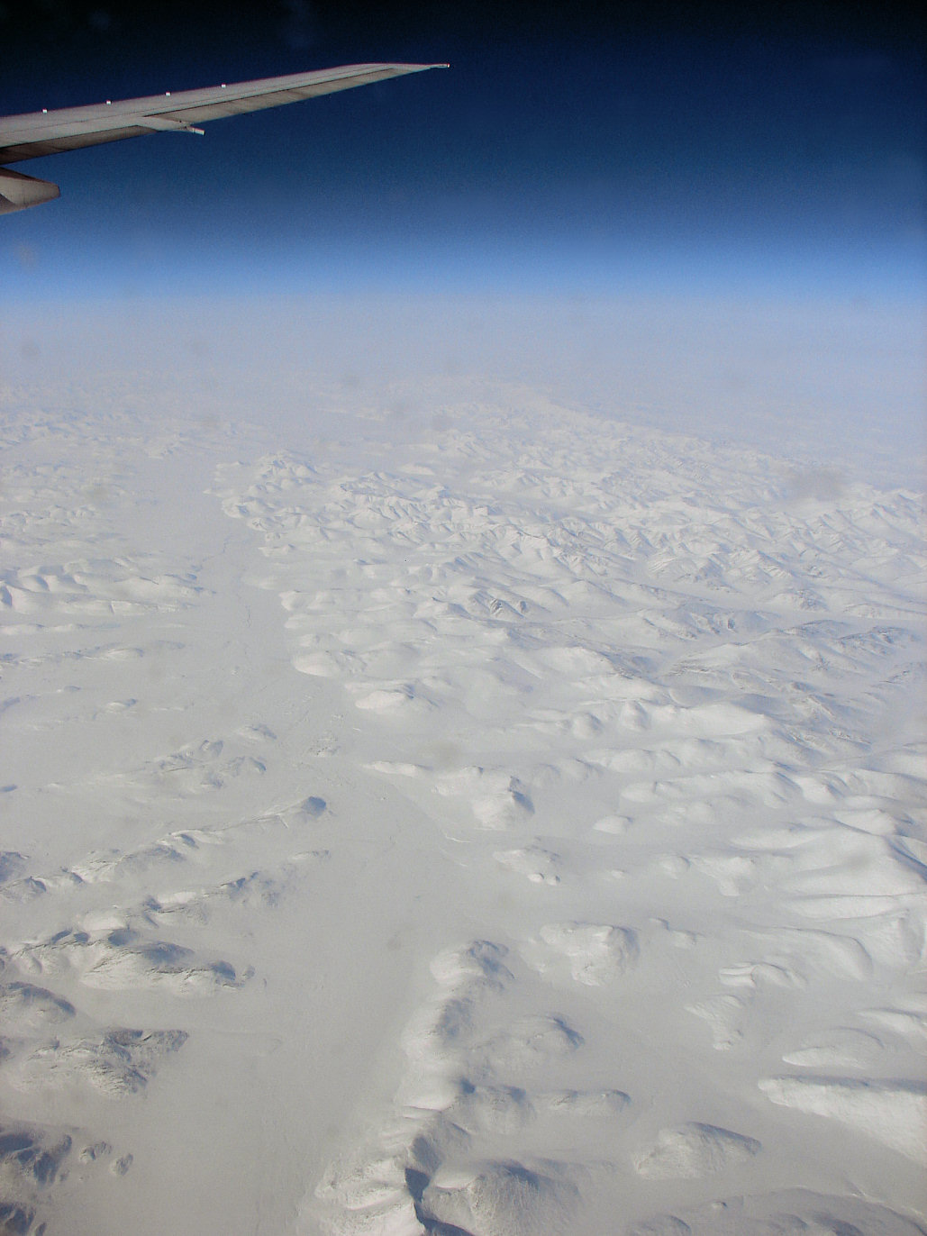
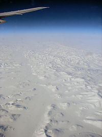 Desolate wilderness of far northern Chukotka
Chukotka is bordered in the north by the Chukchi Sea and the East Siberian Sea, which are part of the Arctic Ocean; in the east by the Bering Strait and the Bering Sea, part of the Pacific Ocean; in the south by Kamchatka Krai and Magadan Oblast; and in the west by the Sakha Republic. The Chukchi Peninsula projects eastward forming the Bering Strait between Russia and Alaska, and encloses the north side of the Gulf of Anadyr. The peninsula's eastern-most point, Cape Dezhnev, is also the eastern-most point of mainland Russia.
Ecologically, Chukotka can be divided into three distinct areas: the northern arctic desert, the central tundra, and the taiga in the south. About half of its area is above the Arctic Circle. This area is very mountainous, containing the Chukotsky Mountains and the Anadyr Range.
Chukotka's rivers spring from its northern and central mountains. The major rivers are:
- Anadyr River, with tributaries Belaya, Tanyurer, and Velikaya Rivers, flowing east to the Gulf of Anadyr.
- Omolon and the Great and Little Anyuy Rivers that flow west into the Kolyma River in Yakutia (Sakha).
- Rauchua, Chaun, Palyavaam, Pegtymel, Chegitun and Amguyema Rivers that flow north into the arctic seas.
The largest lakes are Lake Krasnoye, west of Anadyr, and El'gygytgyn Lake in central Chukotka.
Large parts of Chukotka are covered with moss, lichen, and arctic plants, similar to western Alaska. Surrounding the Gulf of Anadyr and in the river valleys grow small larch, pine, birch, poplar, and willow trees. More than 900 species of plants grow in Chukotka, including 400 species of moss and lichen. It is home to 220 bird species and 30 fresh water fish species.[9]
Climate
Chukotka's climate is influenced by its location on the three neighboring seas: the Bering Sea, the East Siberian Sea, and the Chukchi Sea. The weather is characterized by cold northerly winds that could quickly change to wet southern winds. Cape Navarin has the highest number of hurricanes and storms in Russia. The coastal areas are windy with little precipitation, between 200 and 400 mm per year. Temperature varies from −15 °C (5 °F) to −35 °C (−31 °F) in January and from 5 °C (41 °F) to 14 °C (57 °F) in July. Growing season is short, only 80 to 100 days per year.
History
The first inhabitants were Paleo-Siberian hunters who came to Chukotka from Central and East Asia. The area was then part of the Beringia land bridge that is believed to have enabled human migration to the Americas.
Traditionally Chukotka was the home of the native Chukchi people, Siberian Yupiks, Koryaks, Chuvans, Evens/Lamuts, Yukaghirs, and Russian Old Settlers.
Russian exploration and conquest
After the Russians conquered the Kazan and Astrakhan Khanates in the 16th century, the trade routes to the Urals, Siberia, and Central Asia opened for travel and traders and Cossacks moved eastwards. The Cossacks built forts in strategic locations and subjected the indigenous people to the Tsar.
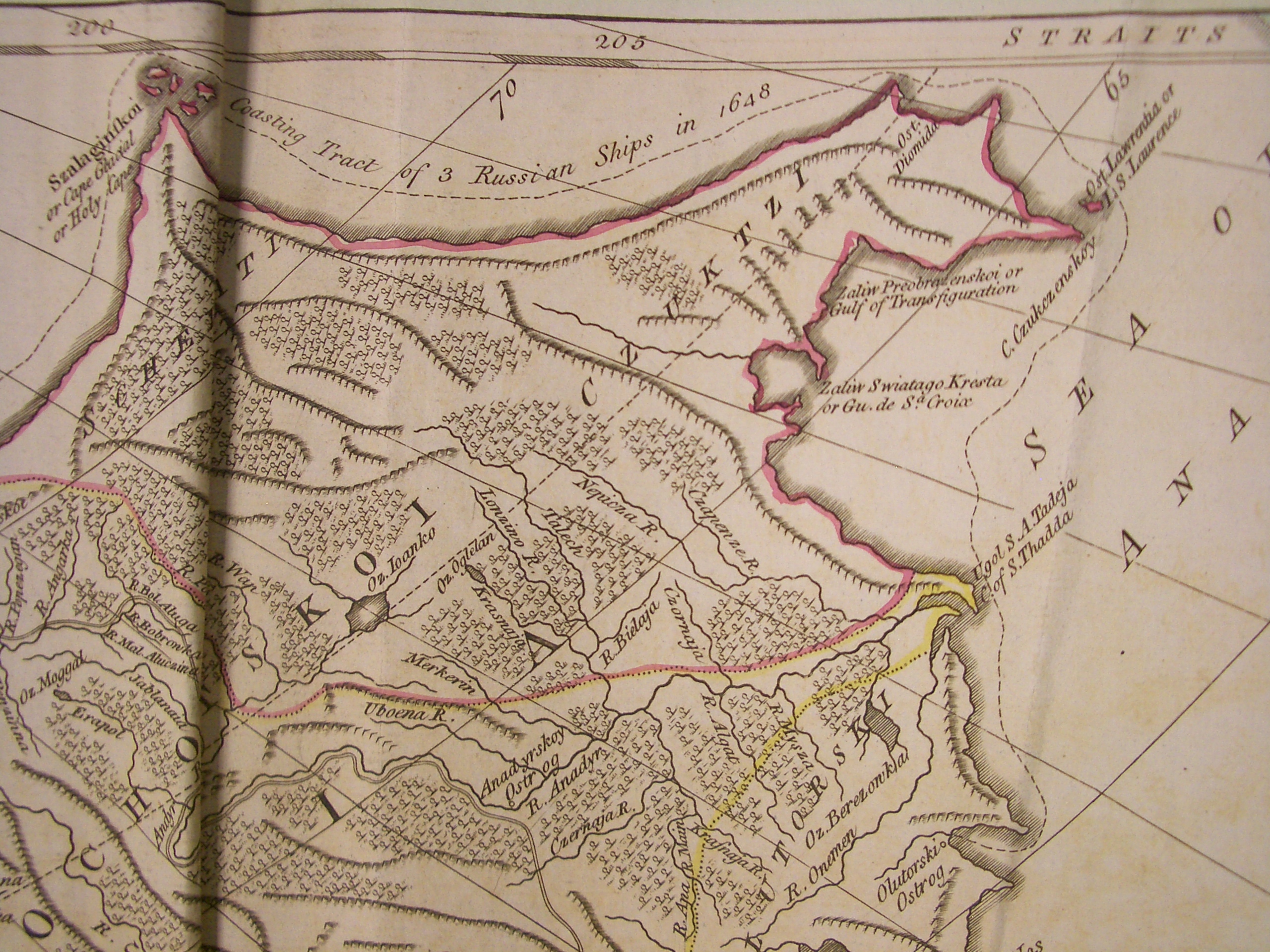
 An early (1773) map of Chukotka, showing the route of Dezhnyov expedition of 1648
During the first half of the 17th century, Russians reached the far north-east. In 1641, the first reference to Chukchi people was made by the Cossacks. In 1649, Russian explorer Semyon Dezhnyov explored the far north-eastern coast and established winter quarters on the upstream portion of the Anadyr River that became the fortified settlement of Anadyrsk. Dezhnyov tried to subjugate the Chukchi and exact tribute during the next ten years, but was mostly unsuccessful. Eventually the fort was abandoned because of the harsh northern conditions and lack of game animals for food.
At the end of the 17th century, the fort regained some importance when the sea route from Anadyrsk to Kamchatka was discovered. It was used as the staging base for expeditions to Kamchatka and all other forts and settlements were made subject to Anadyrsk. When the wealth of Kamchatka's natural resources was discovered, the Russian government started to give the far north-eastern region more serious attention. In 1725, Tsar Peter the Great ordered Vitus Bering to explore Kamchatka and Afanasy Shestakov to lead a military expedition to subjugate the Chukchi. This expedition failed when the fleet suffered shipwreck and the survivors, including Shestakov, were killed by the Chukchi.
In 1731, Dmitry Pavlutsky tried again, aided by Cossacks, Yukaghirs, and Koryaks (indigenous Siberian tribes that were subjugated earlier). Pavlutsky sailed up the Anadyr River and destroyed the Chukchi garrison on the Arctic Ocean. His ruthless methods had some limited success in forcing tribute from some Chukchi. But in 1747, the Chukchi defeated the Russian regiment and killed Pavlutsky.
Realizing that the Chukchi could not easily be subjugated by military means, the Russians changed tactics and offered the Chukchi citizenship in the Russian Emprire. A peace treaty was concluded in 1778 in which the Chukchi were exempted from paying yasak.
That same year, British Captain James Cook made an exploration of Cape North (now Cape Schmidt) and Providence Bay. Anxious that European powers would occupy the area, Tsar Catherine II ordered to explore and map the area. Starting in 1785, an expedition led by Joseph Billings and Gavril Sarychev mapped the Chukchi Peninsula, the west coast of Alaska, and the Aleutian Islands. Then from 1821 to 1825, Ferdinand von Wrangel and Fyodor Matyushkin led expeditions along the coast of the East Siberian Sea and explored the Kolyma, Great Anyuy, and Little Anyuy Rivers.
Western influence
Chukotka remained mostly outside the control of the Russian Empire and consequently other foreign powers (American, British, Norwegian) began to hunt and trade in the area from about 1820 onwards. After the sale of Alaska to the United States, American whalers and traders especially extended their activities into Chukotka and foreign influence reached its peak. By 1880, the Russians reacted by setting up coastal patrols to stop American ships and confiscate their property. And in 1888, the administrative region of Anadyr was created. Yet Russian control diminished again and around 1900, a large stream of foreigners entered Chukotka, lured to the region by the Yukon gold rush in 1898.
In 1909, in order to keep the region within Russian control, two districts were created within the Anadyr Region: the districts of Anadyr and Chukotka. The Russian government granted concessions to foreign companies such as the Hudson's Bay Company and the US Northeast Siberia Company, which was granted gold, iron, and graphite mining rights in the entire Chukotka between 1902 and 1912.
Wrangel Island in particular was subject to claims by the United States and Canada. In 1916, the Russians officially claimed the uninhabited island. But in 1921, Canadian Vilhjalmur Stefansson made a serious attempt to claim it for Canada by populating it and building a small settlement. Another contingent arrived in 1923 but a year later, the Soviets permanently conquered the island, removing the remaining inhabitants, and thereby ending all foreign influence.
Soviet period
From 1919 onwards, the region was subject to collectivization and resettlement of the indigenous people.
When Nazi Germany attacked the Soviet Union in 1941, everything was done to start tin production as quickly as possible in Chukotka. Mining rapidly developed, and this industry would become its economic base. Also during the war, geologists discovered large reserves of gold that would be mined in the 1950s.
In 1977, Chukotka became administratively subordinated to Magadan Oblast.
Post Soviet-Union
In 1991, Chukotka declared its separation to become a subject of the Russian Federation in its own right, a move that was confirmed by the Constitutional Court of the Russian Federation in 1993.
From 2001 to 2008, Roman Abramovich was the Governor of Chukotka. He invested billions of rubles, including his own money, into the Chukotka economy by developing its infrastructure, schools, and housing. This has helped to double the GDP of the region and to more than triple the income of its residents. In 2004, Abramovich tried to resign from this position but was reappointed governor for another term by Vladimir Putin.
Economy
Chukotka has large reserves of oil, natural gas, coal, gold, and tungsten, which are slowly being exploited, but much of the rural population survives on subsistence reindeer herding, whale hunting, and fishing. The urban population is employed in mining, administration, construction, cultural work, education, medicine, and other occupations.
Transportation
Chukotka is mostly roadless and air travel is the main mode of passenger transport. There are local permanent roads between some settlements. In the winter on the rivers are laid Winter roads which connect region settlements in a uniform network.
In 2009, replacement of the emergency bridge through Loren river on constantly operating local road from Lavrentiya to Lorino became the main event of transport of Chukotka.
The main airport is Ugolny Airport near Anadyr. Coastal shipping also takes place, but the ice situation is too severe for at least half the year.
Administrative divisions
 Districts of Chukotka. Chaunsky District and Anadyr town highlightedMain article: Administrative divisions of Chukotka Autonomous Okrug
Chukotka Autonomous Okrug is administratively divided into the following districts:
Arctic coast: northern Bilibinsky District (northwest), Chaunsky District around Chaunskaya Bay, Shmidtovsky District, northern Iultinsky District, Chukotsky District at the eastern cape.
Pacific coast: Providensky District south of Chukotsky, southern Iultinsky District around Kresta Bay, eastern Anadyrsky District at the Anadyr Estuary, Beringovsky District in the south.
Interior: The western quarter of the Okrug is Bilibinsky District and the rest of the interior is Anadyrsky District.
Demographics
- Population (2002): 53,824
- Ethnic groups: Indigenous peoples make up less than one third of the total population. According to the 2002 Census the ‘national composition’ was • Russian 51.86% • Chukchi 23.45% • Ukrainian 9.22% • Eskimo 2.85% • Even 2.61% • Chuvan 1.778% • Tatar 0.99% • Belarusians 0.96% • Yukaghir 0.34% • Chuvash 0.30% • Moldovan 0.24% • Buriat 0.22% • German 0.22% • Bashkir 0.22% • Azeri 0.20% • and a few other groups of less than one hundred persons each. In addition, 2.23% of the inhabitants chose not to specify their ethnic background on the census questionnaire.[10] Historical figures are given below:
census 1939 census 1959 census 1970 census 1979 census 1989 census 2002 Chukchis 12,111 (56.2%) 9,975 (21.4%) 11,001 (10.9%) 11,292 (8.1%) 11,914 (7.3%) 12,622 (23.5%) Chuvans 944 (0.6%) 951 (1.8%) Eskimos 800 (3.7%) 1,064 (2.3%) 1,149 (1.1%) 1,278 (0.9%) 1,452 (0.9%) 1,534 (2.9%) Evens 817 (3.8%) 820 (1.8%) 1,061 (1.0%) 969 (0.7%) 1,336 (0.8%) 1,407 (2.6%) Russians 5,183 (24.1%) 28,318 (60.7%) 70,531 (69.7%) 96,424 (68.9%) 108,297 (66.1%) 27,918 (51.9%) Ukrainians 571 (2.7%) 3,543 (7.6%) 10,393 (10.3%) 20,122 (14.4%) 27,600 (16.8%) 4,960 (9.2%) Others 2,055 (9.5%) 2,969 (6.4%) 7,049 (7.0%) 9,859 (7.0%) 12,391 (7.6%) 4,432 (8.2%) All 21,537 46,689 101,194 139,944 163,934 53,824 Ethnographic maps shows the Yupik Eskimos as the indigenous population of some villages near Provideniya, Chuvans in the Chuvanskoye village some 100 km west of Markovo, the Evens in some inland areas, and the Chukchi throughout the rest of the region.[11]
- Vital statistics
- Source: Russian Federal State Statistics Service
Births Deaths Birth rate Death rate 1970 1,751 599 17.0 5.8 1975 2,113 627 17.0 5.1 1980 2,208 653 15.4 4.6 1985 2,659 627 17.3 4.1 1990 2,208 598 13.8 3.7 1991 1,912 631 12.5 4.1 1992 1,565 763 11.5 5.6 1993 1,191 907 10.1 7.7 1994 1,153 884 11.1 8.5 1995 935 816 10.4 9.1 1996 935 816 11.5 10.1 1997 818 598 10.9 8.0 1998 855 612 12.3 8.8 1999 672 530 10.4 8.2 2000 686 570 11.5 9.6 2001 719 701 12.7 12.4 2002 653 611 12.0 11.3 2003 679 562 13.0 10.8 2004 787 623 15.4 12.2 2005 795 597 15.7 11.8 2006 771 585 15.3 11.6 2007 801 595 15.9 11.8 2008 751 620 15.1 12.4 Governor
The governor of Chukotka until July 3, 2008, business oligarch Roman Abramovich, also the owner of Chelsea F.C. has spent over US$1 billion in the region (partly as normal tax payments) on developing infrastructure and providing direct aid to the inhabitants[12] since becoming governor in 2000. In 2004 there were also reports, however, that Chukotka gave Abramovich's company Sibneft tax breaks in excess of US$450 million.[13]
Religion
The Russian Orthodox Church in Chukotka is represented by the Eparchy (Diocese) of Anadyr and Chukotka (Russian: Анадырская и Чукотская епархия). The controversial conservative Bishop of Anadyr and Chukotka, Diomid, who had occupied the Anadyr see since 2000 and had been instrumental in the development of the church in the peninsula, was sacked by the Holy Synod in the summer of 2008. The diocese has been since run by the archbishop of Khabarovsk and the River, Mark (Tuzhikov) (ru).
See also
References
- ^ Президент Российской Федерации. Указ №849 от 13 мая 2000 г. «О полномочном представителе Президента Российской Федерации в федеральном округе». Вступил в силу 13 мая 2000 г. Опубликован: "Собрание законодательства РФ", №20, ст. 2112, 15 мая 2000 г. (President of the Russian Federation. Decree #849 of May 13, 2000 On the Plenipotentiary Representative of the President of the Russian Federation in a Federal District. Effective as of May 13, 2000).
- ^ Госстандарт Российской Федерации. №ОК 024-95 27 декабря 1995 г. «Общероссийский классификатор экономических регионов. 2. Экономические районы», в ред. Изменения №5/2001 ОКЭР. (Gosstandart of the Russian Federation. #OK 024-95 December 27, 1995 Russian Classification of Economic Regions. 2. Economic Regions, as amended by the Amendment #5/2001 OKER. ).
- ^ Official website of Chukotka Autonomous Okrug. Roman Valentinovich Kopin, Governor of Chukotka Autonomous Okrug (Russian)
- ^ Федеральная служба государственной статистики (Federal State Statistics Service) (2004-05-21). "Территория, число районов, населённых пунктов и сельских администраций по субъектам Российской Федерации (Territory, Number of Districts, Inhabited Localities, and Rural Administration by Federal Subjects of the Russian Federation)" (in Russian). Всероссийская перепись населения 2002 года (All-Russia Population Census of 2002). Federal State Statistics Service. http://perepis2002.ru/ct/html/TOM_01_03.htm. Retrieved 2011-11-01.
- ^ Федеральная служба государственной статистики (Federal State Statistics Service) (2011). "Предварительные итоги Всероссийской переписи населения 2010 года (Preliminary results of the 2010 All-Russian Population Census)" (in Russian). Всероссийская перепись населения 2010 года (All-Russia Population Census of 2010). Federal State Statistics Service. http://www.perepis-2010.ru/results_of_the_census/results-inform.php. Retrieved 2011-04-25.
- ^ Федеральная служба государственной статистики (Federal State Statistics Service) (2004-05-21). "Численность населения России, субъектов Российской Федерации в составе федеральных округов, районов, городских поселений, сельских населённых пунктов – районных центров и сельских населённых пунктов с населением 3 тысячи и более человек (Population of Russia, its federal districts, federal subjects, districts, urban localities, rural localities—administrative centers, and rural localities with population of over 3,000)" (in Russian). Всероссийская перепись населения 2002 года (All-Russia Population Census of 2002). Federal State Statistics Service. http://www.perepis2002.ru/ct/doc/1_TOM_01_04.xls. Retrieved 2010-03-23.
- ^ Правительство Российской Федерации. Постановление №725 от 31 августа 2011 г. «О составе территорий, образующих каждую часовую зону, и порядке исчисления времени в часовых зонах, а также о признании утратившими силу отдельных Постановлений Правительства Российской Федерации». Вступил в силу по истечении 7 дней после дня официального опубликования. Опубликован: "Российская Газета", №197, 6 сентября 2011 г. (Government of the Russian Federation. Resolution #725 of August 31, 2011 On the Composition of the Territories Included into Each Time Zone and on the Procedures of Timekeeping in the Time Zones, as Well as on Abrogation of Several Resolutions of the Government of the Russian Federation. Effective as of after 7 days following the day of the official publication).
- ^ Official the whole territory of Russia according to Article 68.1 of the Constitution of Russia.
- ^ WWF International, The Bering Sea Ecoregion, Chukotka's Natural Heritage at a Glance (Online versionPDF)
- ^ (XLS) National Composition of Population for Regions of the Russian Federation. 2002 Russian All-Population Census. 2002. http://www.perepis2002.ru/ct/doc/English/4-2.xls. Retrieved 2006-07-20.
- ^ Map 3.6 (Chukotskiy Avtonomnyi Okrug) from the series prepared for the INSROP (International Northern Sea Route Programme) Working Paper No. 90 in 1997.
- ^ What Abramovich may do with his money BBC News, 29 September 2005
- ^ Abramovich region found bankrupt BBC News, 21 May 2004
Josh Newell, 'The Russian Far East, A Reference Guide for Conservation and Development',2004
External links
- Official website of Chukotka Autonomous Okrug
- Anadyr - Online
- WWF Chukotka brochure
- Chukotka page with images
Russian Far East Topics Federal subjects Amur Oblast · Jewish Autonomous Oblast · Kamchatka Krai · Magadan Oblast · Primorsky Krai · Sakha Republic · Sakhalin Oblast · Khabarovsk Krai · Chukotka Autonomous OkrugLargest cities Subdivisions of Russia Republics Krais Oblasts - Amur
- Arkhangelsk
- Astrakhan
- Belgorod
- Bryansk
- Chelyabinsk
- Irkutsk
- Ivanovo
- Kaliningrad
- Kaluga
- Kemerovo
- Kirov
- Kostroma
- Kurgan
- Kursk
- Leningrad
- Lipetsk
- Magadan
- Moscow
- Murmansk
- Nizhny Novgorod
- Novgorod
- Novosibirsk
- Omsk
- Orenburg
- Oryol
- Penza
- Pskov
- Rostov
- Ryazan
- Sakhalin
- Samara
- Saratov
- Smolensk
- Sverdlovsk
- Tambov
- Tomsk
- Tula
- Tver
- Tyumen
- Ulyanovsk
- Vladimir
- Volgograd
- Vologda
- Voronezh
- Yaroslavl
Federal cities Autonomous oblasts Autonomous okrugs - Chukotka
- Khanty–Mansi1
- Nenets2
- Yamalo-Nenets1
1administratively subordinated to Tyumen Oblast 2 administratively subordinated to Arkhangelsk Oblast
Categories:- Chukotka Autonomous Okrug
- Autonomous okrugs of Russia
- East Siberian Sea
- Chukchi Sea
- States and territories established in 1930


Wikimedia Foundation. 2010.