- Republic of Karelia
-
Republic of Karelia Республика Карелия (Russian) — Republic — 
Flag
Coat of armsAnthem: Anthem of the Republic of Karelia Coordinates: 63°49′N 33°00′E / 63.817°N 33°ECoordinates: 63°49′N 33°00′E / 63.817°N 33°E Political status Country Russia Federal district Northwestern[1] Economic region Northern[2] Established July 16, 1956[3] Capital Petrozavodsk Government (as of August 2010) - Head[4] Andrey Nelidov[5] - Legislature Legislative Assembly[6] Statistics Area (as of the 2002 Census)[7] - Total 172,400 km2 (66,564.0 sq mi) Area rank 20th Population (2010 Census)[8] - Total 645,205 - Rank 68th - Density 3.74 /km2 (9.7 /sq mi) - Urban 78.1% - Rural 21.9% Population (2002 Census)[9] - Total 716,281 - Rank 67th - Density 4.15 /km2 (10.7 /sq mi) - Urban 75.0% - Rural 25.0% Time zone(s) MSD (UTC+04:00)[10] ISO 3166-2 RU-KR License plates 10 Official languages Russian[11] http://www.gov.karelia.ru/ The Republic of Karelia (Russian: Респу́блика Каре́лия, Respublika Kareliya; Karelian: Karjalan Tazavalda; Finnish: Karjalan tasavalta; Veps: Karjalan Tazovaldkund) is a federal subject of Russia (a republic).
Contents
Geography
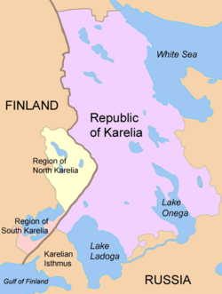
The republic is located in the northwestern part of Russia, taking intervening position between the basins of White and Baltic seas. The White Sea shore line is 630 kilometers (390 mi).
- Area: 172,400 km2 (66,600 sq mi)
- Borders:
- internal: Murmansk Oblast (N), Arkhangelsk Oblast (E/SE), Vologda Oblast (SE/S), Leningrad Oblast (S/SW)
- international: Finland (SW/W/NW) (border line length: 723 km)
- water: White Sea (an inlet of the Barents Sea) (N/NE/E), Lake Onega (SE), Lake Ladoga (SW)
- Highest point: 576 m (1,890 ft), the Nuorunen peak.
Rivers
There are about 27,000 rivers in Karelia. Major rivers include:
- Vodla River (Vodlajoki, 149 km)
- Kem River (Kemijoki, 191 km)
- Kovda River (Koutajoki)
- Shuya River (Suojoki)
- Suna River (Suunujoki) with Kivach Waterfall (Kivatšun vesiputous)
- Vyg River (Uikujoki)
Lakes
There are 60,000 lakes in Karelia. Republic's lakes and swamps contain about 2,000 km³ of high-quality fresh water. Lake Ladoga (Finnish: Laatokka) and Lake Onega (Ääninen) are the largest lakes in Europe. Other lakes include:
 The Regions of North and South Karelia lie in Finland and the Karelian Republic in Russia. The Karelian Isthmus is now part of Leningrad Oblast.
- Nyukozero (Nuokkijärvi)
- Pyaozero (Pääjärvi)
- Segozero (Seesjärvi)
- Syamozero (Säämäjärvi)
- Topozero (Tuoppajärvi)
- Vygozero (Uikujärvi)
National parks
- Vodlozero National Park
- Kalevala National Park
- Paanajärvi National Park
Natural resources
The most part of the republic's territory (148,000 km², or 85%) is composed of state forest stock. The total growing stock of timber resources in the forests of all categories and ages is 807 million m³. The mature and over mature tree stock amounts to 411.8 million m³, of which 375.2 million m³ is coniferous.
Fifty useful minerals are found in Karelia, located in more than 400 deposits and ore bearing layers. Natural resources of the republic include iron ore, diamonds, vanadium, molybdenum, and others.
Climate
The Republic of Karelia is located in the Atlantic continental climate zone. Average temperature in January is -8.0°C, and +16.4°C in July. Average annual precipitation is 500–700 mm.[12]
Administrative divisions
Demographics
- 2010 Census (preliminary results)[8]
- Population: 645,205
- Population: 716,281 (2002 Census)
- Urban: 537.395 (75.0%)
- Rural: 178,886 (25.0%)
- Male: 331,505 (46.3%)
- Female: 384,776 (53.7%)
- Females per 1000 males: 1,161
- Average age: 37.1 years
- Urban: 35.9 years
- Rural: 40.6 years
- Male: 33.9 years
- Female: 39.9 years
- Number of households: 279,915 (with 701,314 people)
- Urban: 208,041 (with 525,964 people)
- Rural: 71,874 (with 175,350 people)
- Vital statistics
- Source: Russian Federal State Statistics Service
Births Deaths Birth rate Death rate 1970 11,346 5,333 15.9 7.5 1975 12,748 6,086 17.6 8.4 1980 12,275 7,374 16.6 10.0 1985 13,201 8,205 17.1 10.7 1990 10,553 8,072 13.3 10.2 1991 8,982 8,305 11.4 10.5 1992 7,969 9,834 10.1 12.5 1993 7,003 11,817 9.0 15.1 1994 6,800 13,325 8.8 17.2 1995 6,729 12,845 8.8 16.7 1996 6,461 11,192 8.5 14.7 1997 6,230 10,306 8.3 13.7 1998 6,382 10,285 8.5 13.8 1999 6,054 11,612 8.2 15.7 2000 6,374 12,083 8.7 16.5 2001 6,833 12,597 9.4 17.4 2002 7,247 13,435 10.1 18.7 2003 7,290 14,141 10.2 19.9 2004 7,320 13,092 10.4 18.5 2005 6,952 12,649 9.9 18.1 2006 6,938 11,716 10.0 16.8 2007 7,319 11,007 10.6 15.9 2008 7,682 11,134 11.1 16.2 - Ethnic groups
According to the 2002 Census, ethnic Russians make up 76.6% of the republic's population, while the ethnic Karelians are only 9.2%. Other groups include Belarusians (5.3%), Ukrainians (2.7%), Finns (2.0%), Vepsians (0.7%), and a host of smaller groups, each accounting for less than 0.5% of the total population. 4,886 people (0.7%) did not indicate their nationality during the Census.
census 1926 census 1939 census 1959 census 1970 census 1979 census 1989 census 2002 Russians 153,967 (57.2%) 296,529 (63.2%) 412,773 (62.7%) 486,198 (68.1%) 522,230 (71.3%) 581,571 (73.6%) 548,941 (76.6%) Karelians 100,781 (37.4%) 108,571 (23.2%) 85,473 (13.0%) 84,180 (11.8%) 81,274 (11.1%) 78,928 (10.0%) 65,651 (9.2%) Belarusians 555 (0.2%) 4,263 (0.9%) 71,900 (10.9%) 66,410 (9.3%) 59,394 (8.1%) 55,530 (7.0%) 37,681 (5.3%) Ukrainians 708 (0.3%) 21,112 (4.5%) 23,569 (3.6%) 27,440 (3.8%) 23,765 (3.2%) 28,242 (3.6%) 19,248 (2.7%) Finns 2,544 (0.9%) 8,322 (1.8%) 27,829 (4.2%) 22,174 (3.1%) 20,099 (2.7%) 18,420 (2.3%) 14,156 (2.0%) Vepsians 8,587 (3.2%) 9,392 (2.0%) 7,179 (1.1%) 6,323 (0.9%) 5,864 (0.8%) 5,954 (0.8%) 4,870 (0.7%) Others 2,194 (0.8%) 20,709 (4.4%) 29,869 (4.5%) 20,726 (2.9%) 19,565 (2.7%) 21,505 (2.7%) 25,734 (3.6%) The Karelian language is close to Finnish, and in recent years, it has been considered by some authorities as a dialect of Finnish. Nevertheless, Eastern Karelian is not completely mutually intelligible with Finnish and could be considered a separate language. Finnish was the second official language of Karelia from the Winter War 1940 up until the 1980s,[13] when perestroika began. Currently Russian is the only official language of the republic, but there is a motion in the republic's government to make Karelian official as well. Finnish has also again been proposed as a second official language for the republic, but the proposal has never been implemented, although Karelian, Veps and Finnish are recognized as "national languages" of the republic.[14]
Economy
Karelia's Gross regional product in 2007 was 109.5 billion rubles.[15] This amounts to 151,210 rubles per capita, which is somewhat lower than the national average of 198,817 rubles.[16]
Industry
Industrial activity in Karelia is dominated by the forest and wood processing sector. Timber logging is carried out by a large number of small enterprises whereas pulp and paper production is concentrated in five large enterprises, which produce about a quarter of Russia's total output of paper.[17] Three largest companies in the pulp and paper sector in 2001 were: OAO Kondopoga (sales of $209.4 mln in 2001), Segezha Pulp and Paper Mill ($95.7 mln) and OAO Pitkjaranta Pulp Factory ($23.7 mln).[12]
In 2007, extractive industries (including extraction of metal ores) amounted to 30% of the republic's industrial output.[15] There are about 53 mining companies in Karelia, employing more than 10,000 people.[18] One of the most important companies in the sector is OAO Karelian Pellet, which is the 5h largest of Russia's 25 mining and ore dressing enterprises involved in ore extraction and iron ore concentrate production. Other large companies in the sector were OAO Karelnerud, Mosavtorod State Unitary Enterprise and Pitkjaranta Mining Directorate State Unitary Enterprise.[12]
Processing industries contributed 56,4% of the overal production in 2007. The latter figure includes pulp-and-paper (23.6%), metals and metal-working (7.9%), woodworking (7.1%), foodstuffs (5.8%) and machine-building (3.9%). Production and distribution of electicity, natural gas and water made up 13.6% of the region's output.[15]
Transport
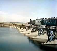
Karelia has a relatively well developed network of transport infrastructure. Water communications connect Karelia with the Barents, Baltic, Black and Caspian Seas through the system of rivers, lakes and canals. Federal railway (see Murmansk Railway) and automobile highways cross Karelia and connect Murmansk Region and Murmansk sea port with St. Petersburg, Moscow, the center of Russia and with Finland. Regular airline service connects Petrozavodsk with Joensuu and Helsinki in Finland.[19] A fast fibre-optic cable link connecting Finnish Kuhmo and Karelian Kostomuksha was built in 2007, providing fast telecommunications.[15]
Foreign trade
The Republic's main export partners in 2001 were Finland (32% of total exports), Germany (7%), Netherlands (7%) and the United Kingdom (6%).[12] Main export products were lumber (over 50%), iron ore pellets (13-15%) paper and cardboard (6-9%) and sawn timber with (5-7%). Many of Karelia's companies have received investments from Finland.[12]
History
Historically, Karelia was a region to the northwest of Russia, east of present-day Finland, controlled by the Novgorod Republic. From the 13th century and onwards, various parts were conquered by Sweden, and incorporated into Swedish Karelia until they were lost to Russia by the Treaty of Nystad in 1721.
In 1920, the province became the Karelian Labour Сommune. In 1923, the province became the Karelian Autonomous Soviet Socialist Republic (Karelian ASSR). From 1940 it was made into the Karelo-Finnish SSR, incorporating the Finnish Democratic Republic which nominally operated in those parts of Finnish Karelia that were occupied by the Soviet Union during the Winter War. Annexed territories were incorporated into Karelo-Finnish SSR, but after the Continuation War the Karelian Isthmus was incorporated into the Leningrad Oblast. Its status was changed back to an ASSR in 1956. During the Continuation War in 1941 Finland occupied large parts of the area but was forced to withdraw in 1944. Though Finland is not currently pursuing any measures to reclaim Karelian lands ceded to Russia, the "Karelian Question" is still a topic present in Finnish politics.
The autonomous Republic of Karelia in its present form was formed on November 13, 1991.
Politics
The highest executive authority in the Republic of Karelia is the Head of the Republic. As of 2010, the Head of the Republic is Andrey Vitalyevich Nelidov, who was elected in June 2010.
The parliament of the Republic of Karelia is the Legislative Assembly comprising fifty deputies elected for a four year term.
The Constitution of the Republic of Karelia was adopted on February 12, 2001.
Culture
Karelia is sometimes called "the songlands" in the Finnish culture, as Karelian poems constitute most of the Karelo-Finnish epic Kalevala.
Religion
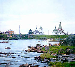
The Karelians have been traditionally Russian Orthodox, known in Finland for their small chapels called tsasouna (variant spelling of Russian "часовня" "chasovnya", chapel) associated with villages or graveyards. However, first Catholicism and then Lutheranism was brought to the area by the Finnish immigrants during Sweden's conquest of Karelia and some Lutheran parishes remain in Karelia.
See also
References
Notes
- ^ Президент Российской Федерации. Указ №849 от 13 мая 2000 г. «О полномочном представителе Президента Российской Федерации в федеральном округе». Вступил в силу 13 мая 2000 г. Опубликован: "Собрание законодательства РФ", №20, ст. 2112, 15 мая 2000 г. (President of the Russian Federation. Decree #849 of May 13, 2000 On the Plenipotentiary Representative of the President of the Russian Federation in a Federal District. Effective as of May 13, 2000).
- ^ Госстандарт Российской Федерации. №ОК 024-95 27 декабря 1995 г. «Общероссийский классификатор экономических регионов. 2. Экономические районы», в ред. Изменения №5/2001 ОКЭР. (Gosstandart of the Russian Federation. #OK 024-95 December 27, 1995 Russian Classification of Economic Regions. 2. Economic Regions, as amended by the Amendment #5/2001 OKER. ).
- ^ "Карельский государственный архив новейшей истории. Путеводитель". Приложение "Административно-территориальное устройство Республики Карелия". 2003.
- ^ Constitution, Article 46.
- ^ Official website of the Republic of Karelia. Andrey Vitalyevich Nelidov
- ^ Constitution, Article 32
- ^ Федеральная служба государственной статистики (Federal State Statistics Service) (2004-05-21). "Территория, число районов, населённых пунктов и сельских администраций по субъектам Российской Федерации (Territory, Number of Districts, Inhabited Localities, and Rural Administration by Federal Subjects of the Russian Federation)" (in Russian). Всероссийская перепись населения 2002 года (All-Russia Population Census of 2002). Federal State Statistics Service. http://perepis2002.ru/ct/html/TOM_01_03.htm. Retrieved 2011-11-01.
- ^ a b Федеральная служба государственной статистики (Federal State Statistics Service) (2011). "Предварительные итоги Всероссийской переписи населения 2010 года (Preliminary results of the 2010 All-Russian Population Census)" (in Russian). Всероссийская перепись населения 2010 года (All-Russia Population Census of 2010). Federal State Statistics Service. http://www.perepis-2010.ru/results_of_the_census/results-inform.php. Retrieved 2011-04-25.
- ^ a b Федеральная служба государственной статистики (Federal State Statistics Service) (2004-05-21). "Численность населения России, субъектов Российской Федерации в составе федеральных округов, районов, городских поселений, сельских населённых пунктов – районных центров и сельских населённых пунктов с населением 3 тысячи и более человек (Population of Russia, its federal districts, federal subjects, districts, urban localities, rural localities—administrative centers, and rural localities with population of over 3,000)" (in Russian). Всероссийская перепись населения 2002 года (All-Russia Population Census of 2002). Federal State Statistics Service. http://www.perepis2002.ru/ct/doc/1_TOM_01_04.xls. Retrieved 2010-03-23.
- ^ Правительство Российской Федерации. Постановление №725 от 31 августа 2011 г. «О составе территорий, образующих каждую часовую зону, и порядке исчисления времени в часовых зонах, а также о признании утратившими силу отдельных Постановлений Правительства Российской Федерации». Вступил в силу по истечении 7 дней после дня официального опубликования. Опубликован: "Российская Газета", №197, 6 сентября 2011 г. (Government of the Russian Federation. Resolution #725 of August 31, 2011 On the Composition of the Territories Included into Each Time Zone and on the Procedures of Timekeeping in the Time Zones, as Well as on Abrogation of Several Resolutions of the Government of the Russian Federation. Effective as of after 7 days following the day of the official publication).
- ^ Official the whole territory of Russia according to Article 68.1 of the Constitution of Russia.
- ^ a b c d e "Republic of Karelia". Russia: All Regions Trade & Investment Guide. CTEC Publishing LLC. 2003.
- ^ http://www.helsinki-hs.net/news.asp?id=20020129IE17
- ^ http://gov.karelia.ru/News/2004/03/0318_08_f.html
- ^ a b c d The Republic of Karelia in 2007 Helsinki School of Economics
- ^ Валовой региональный продукт на душу населения Федеральная служба государственной статистики
- ^ Regional characteristics. Republic of Karelia Helsinki School of Economics
- ^ "Mining industry of the republic has summed up its work in the first six months of the year". Republic of Karelia. http://www.gov.karelia.ru/gov/News/2009/07/0727_06_e.html. Retrieved 2009-08-03.
- ^ The Republic of Karelia
Sources
- Верховный Совет Карельской АССР. №473-ЗРК 30 мая 1978 г. «Конституция Республики Карелия», в ред. Закона №1314-ЗРК от 16 июля 2009 г «О внесении изменений в Конституцию Республики Карелия». Опубликован: отдельной брошюрой. (Supreme Soviet of the Karelian ASSR. #473-ZRK May 30, 1978 Constitution of the Republic of Karelia, as amended by the Law #1314-ZRK of July 16, 2009 On Amending the Constitution of the Republic of Karelia. ).
External links
- (English) (Russian) (Finnish) Official website of the Republic of Karelia
- (English) (Russian) (Finnish) Karelia.ru web server
- (English) (Russian) (Finnish) Heninen.net - various information about Karelia
- (English) Information about Karelians
- (English) Tracing Finland's eastern border-thisisFINLAND
- (English) Saimaa Canal links two Karelias-thisisFINLAND
- (English) ProKarelia (also available in other languages)
Subdivisions of Russia Republics Krais Oblasts - Amur
- Arkhangelsk
- Astrakhan
- Belgorod
- Bryansk
- Chelyabinsk
- Irkutsk
- Ivanovo
- Kaliningrad
- Kaluga
- Kemerovo
- Kirov
- Kostroma
- Kurgan
- Kursk
- Leningrad
- Lipetsk
- Magadan
- Moscow
- Murmansk
- Nizhny Novgorod
- Novgorod
- Novosibirsk
- Omsk
- Orenburg
- Oryol
- Penza
- Pskov
- Rostov
- Ryazan
- Sakhalin
- Samara
- Saratov
- Smolensk
- Sverdlovsk
- Tambov
- Tomsk
- Tula
- Tver
- Tyumen
- Ulyanovsk
- Vladimir
- Volgograd
- Vologda
- Voronezh
- Yaroslavl
Federal cities Autonomous oblasts Autonomous okrugs 1administratively subordinated to Tyumen Oblast 2 administratively subordinated to Arkhangelsk Oblast
Politics of Europe Sovereign
states- Albania
- Andorra
- Armenia
- Austria
- Azerbaijan
- Belarus
- Belgium
- Bosnia and Herzegovina
- Bulgaria
- Croatia
- Cyprus
- Czech Republic
- Denmark
- Estonia
- Finland
- France
- Georgia
- Germany
- Greece
- Hungary
- Iceland
- Ireland
- Italy
- Kazakhstan
- Latvia
- Liechtenstein
- Lithuania
- Luxembourg
- Macedonia
- Malta
- Moldova
- Monaco
- Montenegro
- Netherlands
- Norway
- Poland
- Portugal
- Romania
- Russia
- San Marino
- Serbia
- Slovakia
- Slovenia
- Spain
- Sweden
- Switzerland
- Turkey
- Ukraine
- United Kingdom
- (England
- Northern Ireland
- Scotland
- Wales)
- Vatican City
States with limited
recognition- Abkhazia
- Kosovo
- Nagorno-Karabakh
- Northern Cyprus
- South Ossetia
- Transnistria
Dependencies
and other territories- Åland
- Faroe Islands
- Gibraltar
- Guernsey
- Jan Mayen
- Jersey
- Isle of Man
- Svalbard
Other entities - European Union
Categories:- Republic of Karelia
- Karelia
- Republics of Russia
- States and territories established in 1956
- History of Karelia
Wikimedia Foundation. 2010.


