- Komi Republic
-
For other uses, see Komi (disambiguation).
Komi Republic Республика Коми (Russian)
Коми Республика (Komi)— Republic — 
Flag
Coat of armsAnthem: National Anthem of the Komi Republic 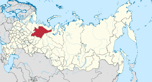
Coordinates: 64°17′N 54°28′E / 64.283°N 54.467°ECoordinates: 64°17′N 54°28′E / 64.283°N 54.467°E Political status Country Russia Federal district Northwestern[1] Economic region Northern[2] Established August 22, 1921 Capital Syktyvkar Government (as of August 2010) - Head[3] Vyacheslav Gayzer[4] - Legislature State Council[3] Statistics Area (as of the 2002 Census)[5] - Total 415,900 km2 (160,579.9 sq mi) Area rank 13th Population (2010 Census)[6] - Total 901,642 - Rank 58th - Density 2.17 /km2 (5.6 /sq mi) - Urban 77.0% - Rural 23.0% Population (2002 Census)[7] - Total 1,018,674 - Rank 54th - Density 2.45 /km2 (6.3 /sq mi) - Urban 75.3% - Rural 24.7% Time zone(s) MSD (UTC+04:00)[8] ISO 3166-2 RU-KO License plates 11 Official languages Russian;[9] Komi[10] http://www.rkomi.ru/en/ The Komi Republic (Russian: Респу́блика Ко́ми, Respublika Komi; Komi: Коми Республика, Komi Respublika) is a federal subject of Russia (a republic).
Contents
Geography
The republic is situated to the west of the Ural mountains, in the north-east of the East European Plain. Forests cover over 70% of the territory and swamps cover approximately 15%.
- Area: 415,900 square kilometers (160,600 sq mi)
- Borders (all internal): Nenets (NW/N), Yamalo-Nenets (NE/E), Khanty-Mansi (E), Sverdlovsk (SE), Perm Krai (S), Kirov (S/SW), and Arkhangelsk (W).
- Highest point: Mount Narodnaya (1,894 m)
- Maximum N→S distance: 785 kilometers (488 mi)
- Maximum E→W distance: 695 kilometers (432 mi)
Rivers
Major rivers include:
Lakes
There are many lakes in the republic. Major lakes include:
- Sindorskoye Lake
- Yam-Ozero Lake
Natural resources
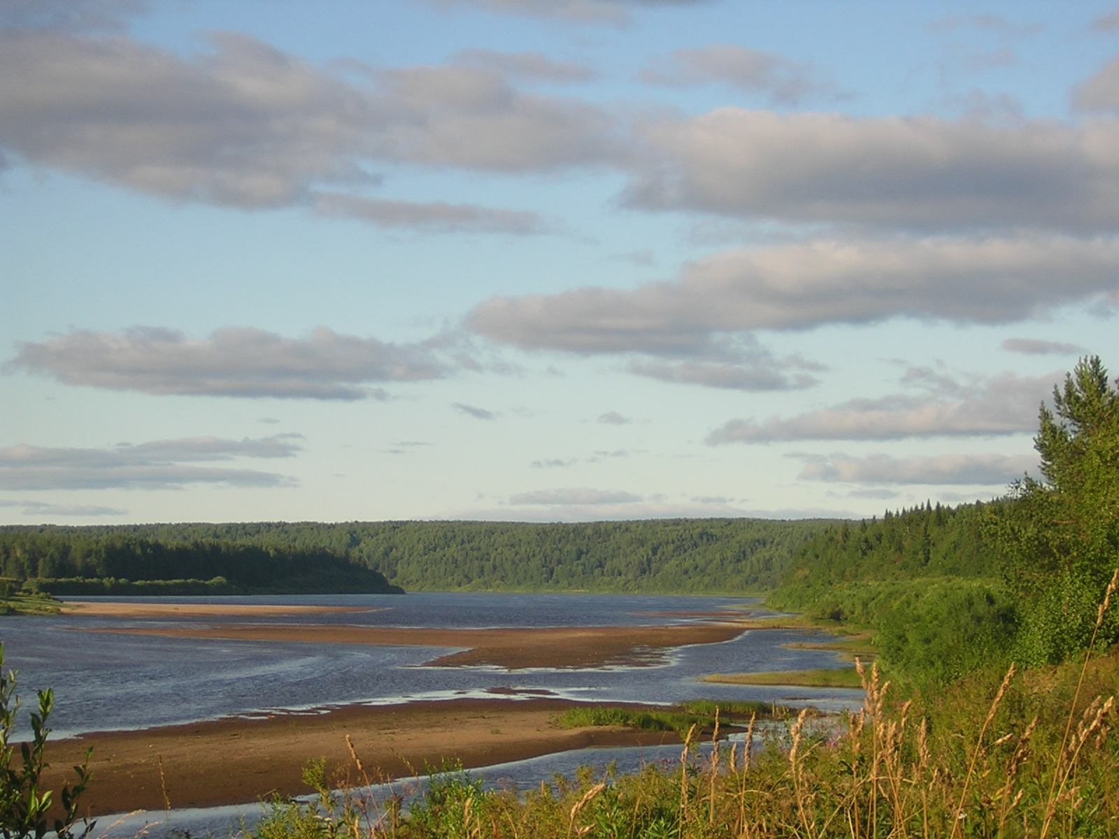
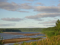 The Vym River, Komi Republic, Russia
The republic's natural resources include coal, oil, natural gas, gold, diamonds and timber. Native reindeer are in abundance, and have been intentionally bred for human usage by the indigenous population from the beginning.[citation needed]
Around 32,800 km² of mostly boreal forest (as well as some alpine tundra and meadows) in the Republic's Northern Ural Mountains have been recognized in 1995 as a UNESCO World Heritage site, Virgin Komi Forests. It is the first natural UNESCO World Heritage site in Russia and the largest expanse of virgin forests in Europe. The site includes two pre-existing protected areas: Pechora-Ilych Nature Reserve (created in 1930) and Yugyd Va National Park (created in 1994).
Climate
Winters in the republic are long and cold, and the summers, while short, are quite warm.
- Average January temperature: −17 °C (1 °F) (southern parts) to −20 °C (−4 °F) (northern parts)
- Average July temperature: 11 °C (52 °F) (northern parts) to 15 °C (59 °F) (southern parts)
- Lowest recorded temperature: −58.1 °C (−72.6 °F) (village of Ust-Shchuger)
- Average annual precipitation: 625 mm (24.6 in)
Manpupuner and the 7 Strong Men Rock Formations
Deemed one of the Seven Wonders of Russia, Komi Republic is home to Manpupuner (Man-Pupu-Nyer), a mysterious site in the northern Ural mountains, in the Troitsko-Pechorsky District, made out of seven rock towers bursting out of the flat plateau known as the “7 strong men“. Manpupuner is a very popular attraction in Russia, but not on an international level and information regarding its origin is scarce. We know however that their height and abnormal shapes make the top of these rock giants inaccessible even to experienced rock-climbers.
Administrative divisions
Demographics
- 2010 Census (preliminary results)[6]
- Population: 901,642
- Population: 1,018,674
- Urban: 766,587 (75.3%)
- Rural: 252,087 (24.7%)
- Male: 488,316 (47.9%)
- Female: 530,358 (52.1%)
- Females per 1000 males: 1,086
- Average age: 34.5 years
- Urban: 33.7 years
- Rural: 36.8 years
- Male: 32.3 years
- Female: 36.8 years
- Number of households: 381,626 (with 992,612 people)
- Urban: 289,854 (with 749,329 people)
- Rural: 91,772 (with 243,283 people)
- Vital statistics
- Source: Russian Federal State Statistics Service
Births Deaths Birth rate Death rate 1920 4,760 4,353 1930 10,256 6,574 1940 14,976 12,134 1945 6,432 6,185 1950 20,087 6,002 37.6 11.2 1960 25,578 5,010 30.6 6.0 1965 18,956 5,241 20.2 5.6 1970 16,462 6,276 17.0 6.5 1975 18,899 7,284 18.1 7.0 1980 20,685 9,169 18.2 8.1 1981 21,244 9,103 18.4 7.9 1982 23,420 8,758 20.0 7.5 1983 23,806 9,250 20.1 7.8 1984 24,217 9,486 20.2 7.9 1985 23,303 9,334 19.2 7.7 1986 24,176 8,112 19.7 6.6 1987 23,616 8,544 19.0 6.9 1988 20,916 8,930 16.7 7.1 1989 18,481 8,857 14.7 7.1 1990 16,930 9,321 13.6 7.5 1991 15,589 9,665 12.7 7.9 1992 13,880 11,426 11.4 9.4 1993 12,158 14,642 10.1 12.2 1994 11,835 16,074 10.1 13.7 1995 11,105 15,057 9.7 13.2 1996 10,900 13,674 9.7 12.2 1997 10,388 12,244 9.4 11.1 1998 10,793 11,545 9.9 10.6 1999 9,680 12,253 9.1 11.5 2000 9,906 13,594 9.4 12.9 2001 10,325 13,968 10.0 13.5 2002 11,177 15,265 10.9 14.9 2003 11,462 15,810 11.3 15.6 2004 11,489 15,210 11.5 15.2 2005 10,975 15,074 11.1 15.2 2006 10,872 13,519 11.1 13.8 2007 11,523 12,304 11.9 12.7 2008 11,719 12,270 12.2 12.7 - Ethnic groups
According to the 2002 Census, ethnic Russians make up 59.6% of the republic's population, while the ethnic Komi are only 25.2%. Other groups include Ukrainians (6.1%), Tatars (15,680 or 1.5%), Belarusians (15,212 or 1.5%), Ethnic Germans (9,246 or 0.9%), Chuvash (7,529 or 0.7%), Azeris (6,066 or 0.6%), and a host of smaller groups, each accounting for less than 0.5% of the total population. 5,700 people (0.6%) did not indicate their nationalities during the Census.
census 1926 census 1939 census 1959 census 1970 census 1979 census 1989 census 2002 Komi 191,245 (92.2%) 231,301 (72.5%) 245,074 (30.4%) 276,178 (28.6%) 280,798 (25.3%) 291,542 (23.3%) 256,464 (25.2%) Russians 13,731 (6.6%) 70,226 (22.0%) 389,995 (48.4%) 512,203 (53.1%) 629,523 (56.7%) 721,780 (57.7%) 607,021 (59.6%) Ukrainians 34 (0.0%) 6,010 (1.9%) 80,132 (9.9%) 82,955 (8.6%) 94,154 (8.5%) 104,170 (8.3%) 62,115 (6.1%) Others 2,304 (1.1%) 11,459 (3.6%) 90,998 (11.3%) 93,466 (9.7%) 105,886 (9.5%) 133,355 (10.7%) 93,074 (9.1%) Vital statistics for 2007
Source: [1]
Vital Statistics Births 2007 Deaths 2007 BR 2007 DR 2007 NGR 2007 BR Jan-aug 2007 BR J-A 08 DR J-A 07 DR J-A 08 NGR J-A 07 NGR J-A 08 Komi Republic 11,523 12,304 11.9 13.8 -0.19% 11.8 11.9 12.9 12.6 -0.11% -0.07% Urban 8,087 8,204 NA NA NA 11.4 11.3 11.7 11.2 -0.03% 0.01% Rural 3,436 4,100 NA NA NA 13.0 13.8 16.4 17.0 -0.34% -0.32% Syktyvkar 3,013 2,733 12.3 12.1 0.02% 12.3 11.6 11.6 11.1 0.07% 0.05% Vorkuta 1,126 1,064 9.5 10.3 -0.08% 9.3 9.7 8.8 8.2 0.05% 0.15% Vuktyl 210 200 12.6 12.2 0.04% 12.9 11.2 12.1 14.7 0.08% -0.35% Inta 414 495 10.2 13.7 -0.35% 10 10.4 12.1 13.2 -0.21% -0.28% Pechora 714 916 11.3 16.2 -0.49% 11.3 11.4 14.8 14.5 -0.35% -0.31% Sosnogorsk 582 725 11.6 15.8 -0.42% 10.9 11.7 14.8 14 -0.39% -0.23% Usinsk 614 459 11.9 8.9 0.30% 11.5 12.1 8.8 8.8 0.27% 0.33% Ukhta 1,414 1,612 11.1 12.7 -0.16% 11 11.4 13.1 11.4 -0.21% 0.00% Izhemsky District 315 368 15.6 1.5 -0.09% 15.2 17.4 18.2 18.2 -0.30% -0.08% Knyazhpogostsky District 290 411 10.9 16.8 -0.59% 10.2 10.2 15.5 14.6 -0.53% -0.44% Koygorodsky District 129 140 13.9 18.6 -0.47% 14.1 14.1 15.1 19.1 -0.10% -0.50% Kortkerossky District 314 373 13.7 17.8 -0.41% 14 12.2 15.8 16.7 -0.18% -0.45% Priluzsky District 318 402 13.9 21.8 -0.79% 13 14.2 16.6 19.2 -0.36% -0.50% Syktyvdinsky District 308 341 12.8 14.6 -0.18% 13.2 15.6 15.1 14.8 -0.19% 0.08% Sysolsky District 214 302 13.3 17.0 -0.37% 14.7 12 18.8 17.9 -0.41% -0.59% Troitsko-Pechorsky District 193 262 12.0 19.1 -0.71% 12.2 13.9 16.7 18.5 -0.45% -0.46% Udorsky District 280 305 11.9 14.3 -0.24% 11.7 13 12.5 13.3 -0.08% -0.03% Ust-Vymsky District 443 543 14.0 19.4 -0.54% 14.9 12.7 17.7 16 -0.28% -0.33% Ust-Kulomsky District 453 433 14.8 19.5 -0.47% 15.1 15.1 13.9 15.2 0.12% -0.01% Ust-Tsilemsky District 179 220 12.5 16.0 -0.35% 11.1 15.3 16.3 17.8 -0.52% -0.25 History
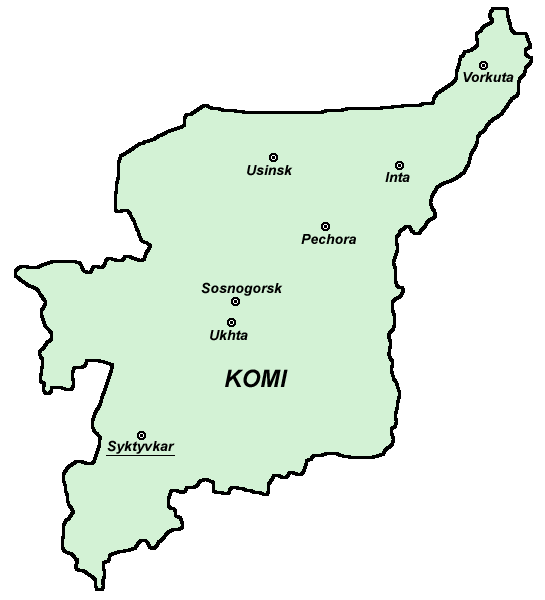
 Map of the Komi Republic
The Komi first appear in the records of the Novgorod Republic in the 12th century, when Novgorodian (East Slavic) traders travelled to the Perm region in search of furs and animal hides. The Komi territories came under the influence of Muscovy in the late Middle Ages (late 15th to early 16th centuries). The site of Syktyvkar has been settled since the 16th century. It was known as Sysolskoye (Сысольскoe). In 1780, under Catherine the Great, it was renamed to Ust-Sysolsk (Усть-Сысольск) and used as a penal colony.
Starting from the expedition led by Alexander von Keyserling in 1843, the Komi territory was most extensively explored in the 19th and the beginning of the 20th centuries by the Russians, who found ample reservoirs of various minerals, as well as timber, to exploit. After the founding of the Soviet Union, the Komi-Zyryan Autonomous Oblast was established on August 22, 1921[11], and on December 5, 1936, it was reorganized into the Komi Autonomous Soviet Socialist Republic with its administrative center located at the town of Syktyvkar.
Many of the "settlers" who came in the early 20th century were prisoners of the Gulag who were sent by the hundreds of thousands to perform forced labor in the Arctic regions of the USSR. Towns sprang up around labor-camp sites, which were initially carved out of the untouched tundra and taiga by gangs of prisoners. The first mine, "Rudnik No. 1," became the city of Vorkuta, and the other towns of the region have similar origins: "Prisoners planned and built all of the republic's major cities, not just Ukhta but also Syktyvkar, Pechora, Vorkuta, and Inta. Prisoners built Komi's railways and roads, as well as its original industrial infrastructure."[12]
Politics
The head of government in the Komi Republic is the Head of the Republic. As of 2011, the head of the republic is Vyacheslav Gayzer.
The State Council is the legislature.
Economy
The Komi Republic's major industries include oil processing, timber, woodworking, natural gas and electric power industries. Major industrial centers are Syktyvkar, Inta, Pechora, Sosnogorsk, Ukhta, and Vorkuta.
Transportation
Railroad transportation is very well developed. The most important railroad line is Kotlas–Vorkuta–Salekhard, which is used to ship most goods in and out of the republic. The rivers Vychegda and Pechora are navigable. There are airports in Syktyvkar, Ukhta, and Vorkuta.
In 1997, total railroad trackage was 1,708 km, automobile roads 4,677 km.
Education
There are over 450 secondary schools in the republic (with ~180,000 students). The most important higher education facilities include Syktyvkar State University and Ukhta State Technical University.
Sports
Stroitel have played in the highest division of Russian Bandy League for a long time.
See also
- Music of the Komi Republic
- Komi-Permyak Okrug
- Komi mythology
- Udoria
- Extreme points of Europe
References
- ^ Президент Российской Федерации. Указ №849 от 13 мая 2000 г. «О полномочном представителе Президента Российской Федерации в федеральном округе». Вступил в силу 13 мая 2000 г. Опубликован: "Собрание законодательства РФ", №20, ст. 2112, 15 мая 2000 г. (President of the Russian Federation. Decree #849 of May 13, 2000 On the Plenipotentiary Representative of the President of the Russian Federation in a Federal District. Effective as of May 13, 2000).
- ^ Госстандарт Российской Федерации. №ОК 024-95 27 декабря 1995 г. «Общероссийский классификатор экономических регионов. 2. Экономические районы», в ред. Изменения №5/2001 ОКЭР. (Gosstandart of the Russian Federation. #OK 024-95 December 27, 1995 Russian Classification of Economic Regions. 2. Economic Regions, as amended by the Amendment #5/2001 OKER. ).
- ^ a b Constitution, Article 8
- ^ Official website of the Komi Republic. Vyacheslav Gayzer (Russian)
- ^ Федеральная служба государственной статистики (Federal State Statistics Service) (2004-05-21). "Территория, число районов, населённых пунктов и сельских администраций по субъектам Российской Федерации (Territory, Number of Districts, Inhabited Localities, and Rural Administration by Federal Subjects of the Russian Federation)" (in Russian). Всероссийская перепись населения 2002 года (All-Russia Population Census of 2002). Federal State Statistics Service. http://perepis2002.ru/ct/html/TOM_01_03.htm. Retrieved 2011-11-01.
- ^ a b Федеральная служба государственной статистики (Federal State Statistics Service) (2011). "Предварительные итоги Всероссийской переписи населения 2010 года (Preliminary results of the 2010 All-Russian Population Census)" (in Russian). Всероссийская перепись населения 2010 года (All-Russia Population Census of 2010). Federal State Statistics Service. http://www.perepis-2010.ru/results_of_the_census/results-inform.php. Retrieved 2011-04-25.
- ^ a b Федеральная служба государственной статистики (Federal State Statistics Service) (2004-05-21). "Численность населения России, субъектов Российской Федерации в составе федеральных округов, районов, городских поселений, сельских населённых пунктов – районных центров и сельских населённых пунктов с населением 3 тысячи и более человек (Population of Russia, its federal districts, federal subjects, districts, urban localities, rural localities—administrative centers, and rural localities with population of over 3,000)" (in Russian). Всероссийская перепись населения 2002 года (All-Russia Population Census of 2002). Federal State Statistics Service. http://www.perepis2002.ru/ct/doc/1_TOM_01_04.xls. Retrieved 2010-03-23.
- ^ Правительство Российской Федерации. Постановление №725 от 31 августа 2011 г. «О составе территорий, образующих каждую часовую зону, и порядке исчисления времени в часовых зонах, а также о признании утратившими силу отдельных Постановлений Правительства Российской Федерации». Вступил в силу по истечении 7 дней после дня официального опубликования. Опубликован: "Российская Газета", №197, 6 сентября 2011 г. (Government of the Russian Federation. Resolution #725 of August 31, 2011 On the Composition of the Territories Included into Each Time Zone and on the Procedures of Timekeeping in the Time Zones, as Well as on Abrogation of Several Resolutions of the Government of the Russian Federation. Effective as of after 7 days following the day of the official publication).
- ^ Official the whole territory of Russia according to Article 68.1 of the Constitution of Russia.
- ^ Constitution, Article 67
- ^ Коми Автономная Советская Социалистическая Республика. Great Soviet Encyclopedia. http://slovari.yandex.ru/~%D0%BA%D0%BD%D0%B8%D0%B3%D0%B8/%D0%91%D0%A1%D0%AD/%D0%9A%D0%BE%D0%BC%D0%B8%20%D0%90%D0%B2%D1%82%D0%BE%D0%BD%D0%BE%D0%BC%D0%BD%D0%B0%D1%8F%20%D0%A1%D0%BE%D0%B2%D0%B5%D1%82%D1%81%D0%BA%D0%B0%D1%8F%20%D0%A1%D0%BE%D1%86%D0%B8%D0%B0%D0%BB%D0%B8%D1%81%D1%82%D0%B8%D1%87%D0%B5%D1%81%D0%BA%D0%B0%D1%8F%20%D0%A0%D0%B5%D1%81%D0%BF%D1%83%D0%B1%D0%BB%D0%B8%D0%BA%D0%B0/.
- ^ Anne Applebaum, Gulag: A History (Random House, Inc., 2004: ISBN 1400034094), pp. 78, 82.
Sources
- 17 февраля 1994 г. «Конституция Республики Коми», в ред. Закона №44-РЗ от 4 мая 2008 г. (February 17, 1994 Constitution of the Komi Republic, as amended by the Law #44-RZ of May 4, 2008. ).
Further reading
- Pearson, M., Ojanen, P., Havimo, M., Kuuluvainen, T. & Vasander, H. (eds.) 2007. On the European Edge — Journey through Komi Nature and Culture. University of Helsinki Department of Forest Ecology Publications 36. 216 p. ISBN 978-952-10-3898-3.
- Strogoff, M., Brochet, P. & Auzias, D. 2005. Guidebook Komi Republic. Avant-Garde Publishers, Moscow. 176. p. ISBN 5-86394-255-X.
External links
- (Russian) Official site of the Republic of Komi
- (Russian) Website of Syktyvkar City - The Capital of the Republic of Komi
- (Russian) Official website of the Vorkuta City
- (English) Official site of the Syktyvkar State University)
- (Russian) Official site of the Syktyvkar State University)
- (Russian) Official site of the Ukhta State Technical University
- (Russian) Snowboarding in Komi Republic
- (Russian) History Komi
- (English) Map of the Komi Republic
- (English) Historic-demographic note on the Nenets of the Komi Republic
- (English) Virgin Komi Forests at Natural Heritage Protection Fund
Subdivisions of Russia Republics Krais Oblasts - Amur
- Arkhangelsk
- Astrakhan
- Belgorod
- Bryansk
- Chelyabinsk
- Irkutsk
- Ivanovo
- Kaliningrad
- Kaluga
- Kemerovo
- Kirov
- Kostroma
- Kurgan
- Kursk
- Leningrad
- Lipetsk
- Magadan
- Moscow
- Murmansk
- Nizhny Novgorod
- Novgorod
- Novosibirsk
- Omsk
- Orenburg
- Oryol
- Penza
- Pskov
- Rostov
- Ryazan
- Sakhalin
- Samara
- Saratov
- Smolensk
- Sverdlovsk
- Tambov
- Tomsk
- Tula
- Tver
- Tyumen
- Ulyanovsk
- Vladimir
- Volgograd
- Vologda
- Voronezh
- Yaroslavl
Federal cities Autonomous oblasts Autonomous okrugs 1administratively subordinated to Tyumen Oblast 2 administratively subordinated to Arkhangelsk Oblast
History of Europe Prehistoric Europe Classical Antiquity Classical Greece · Roman Republic · Hellenistic period · Roman Empire · Late Antiquity · Early Christianity · Crisis of the 3rd century · Fall of the Roman EmpireMiddle Ages Early Middle Ages · Migration Period · Byzantine Empire · Christianization · Kievan Rus · High Middle Ages · Holy Roman Empire · Crusades · Feudalism · Late Middle Ages · Hundred Years' War · RenaissanceEarly Modern Europe Reformation · Age of Discovery · Baroque · Thirty Years' War · Absolutism · Ottoman Empire · Portuguese Empire · Spanish Empire · Early modern France · Polish–Lithuanian Commonwealth · Swedish Empire · Dutch Republic · British Empire · Habsburg Empire · Russian EmpireModern history See also Politics of Europe Sovereign
states- Albania
- Andorra
- Armenia
- Austria
- Azerbaijan
- Belarus
- Belgium
- Bosnia and Herzegovina
- Bulgaria
- Croatia
- Cyprus
- Czech Republic
- Denmark
- Estonia
- Finland
- France
- Georgia
- Germany
- Greece
- Hungary
- Iceland
- Ireland
- Italy
- Kazakhstan
- Latvia
- Liechtenstein
- Lithuania
- Luxembourg
- Macedonia
- Malta
- Moldova
- Monaco
- Montenegro
- Netherlands
- Norway
- Poland
- Portugal
- Romania
- Russia
- San Marino
- Serbia
- Slovakia
- Slovenia
- Spain
- Sweden
- Switzerland
- Turkey
- Ukraine
- United Kingdom
- (England
- Northern Ireland
- Scotland
- Wales)
- Vatican City
States with limited
recognition- Abkhazia
- Kosovo
- Nagorno-Karabakh
- Northern Cyprus
- South Ossetia
- Transnistria
Dependencies
and other territories- Åland
- Faroe Islands
- Gibraltar
- Guernsey
- Jan Mayen
- Jersey
- Isle of Man
- Svalbard
Other entities - European Union
Categories:- Komi Republic
- States and territories established in 1921
- Republics of Russia


Wikimedia Foundation. 2010.