- Salekhard
-
Salekhard (English)
Салехард (Russian)
Саляʼ харад (Nenets language)
Пуӆңават (Khanty language)- Town[1] - 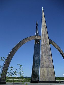
Arctic Circle monument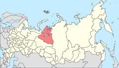
Location of Yamalo-Nenets Autonomous Okrug in Russia
 Salekhard
Coordinates: 66°32′N 66°36′E / 66.533°N 66.6°ECoordinates: 66°32′N 66°36′E / 66.533°N 66.6°E 

Coat of arms Flag Administrative status Country Russia Federal subject Yamalo-Nenets Autonomous Okrug Municipal status Urban okrug Salekhard Urban Okrug[citation needed] Mayor[citation needed] Alexander Spirin[citation needed] Statistics Population (2010 Census,
preliminary)42,494 inhabitants[2] Population (2002 Census) 36,827 inhabitants[3] Time zone YEKST (UTC+06:00)[4] Founded 1595[1] Previous names Obdorsk (until 1933)[1] Dialing code(s) +7 34922[5] Official website Salekhard (Russian: Салеха́рд; Nenets: Саляʼ харад, lit. house on a peninsula) is a town and the administrative center of Yamalo-Nenets Autonomous Okrug, Russia. It is believed to be the only town in the world that is located right on a Polar Circle. Population: 42,494 (2010 Census preliminary results);[2] 36,827 (2002 Census);[3] 32,334 (1989 Census).[6]
It is served by Salekhard Airport.
Contents
History
The settlement of Obdorsk (Обдорск) was founded in 1595, in the place of a Khanty settlement called Polnovat-Vozh (Полноват-вож), by Russian settlers after the conquest of Siberia. It was situated on the River Ob, and its name supposedly derives from that. The land around Obdorsk was referred to as Obdorsky krai, or Obdoriya.
The town was often used as a place of exile during the Czarist and Soviet periods. Among notable people who spent time here was the Doukhobor spriritual leader Peter Vasilevich Verigin. The town and nearby area contained three Soviet camps where approximately 6,500 prisoners were held, arrested for their belief in God. At the port of Salekhard, approximately 1,500 prisoners loaded and unloaded goods at the dock, or mined metal ores. About 5,000 prisoners in two camps near Salekhard were assigned to polish diamonds mined from Mirnyi.
On December 10, 1930, Obdorsk became the administrative center of the new Yamal (Nenets) National Okrug (Ямальский (Ненецкий) национальный округ). It was renamed Salekhard in 1933, and granted town status in 1938.
The nearest railway is at Labytnangi on the opposite side of the river Ob. From 1949 to 1953, the Salekhard-Igarka Railway project made an unsuccessful attempt to extend the line to Igarka, claiming the lives of thousands of Gulag prisoners. The section of railway from Salekhard to Nadym was completed and remained in use for some time in the Soviet era, although it was later abandoned. It is currently being rebuilt, along with a long-awaited bridge across the Ob between Labytnangi and Salekhard.
As of 2010[update], cars and trucks cross the river by driving across the frozen river ice for 9–10 months a year. In the summer a ferry operates, "but twice a year, during floating of ice, Salekhard lives in a standalone mode, completely cut off from the world. Only helicopter in case of emergency. Native people always build safety stock of food at home, in the shops, in the market for this period, but they still have seasonal price increasing."[7]
Climate
Climate data for Salekhard Month Jan Feb Mar Apr May Jun Jul Aug Sep Oct Nov Dec Year Average high °C (°F) −20.1
(−4.2)−18.7
(−1.7)−10.8
(12.6)−4.9
(23.2)2.0
(35.6)12.3
(54.1)19.4
(66.9)15.3
(59.5)8.6
(47.5)−1.8
(28.8)−11.7
(10.9)−16.3
(2.7)−2.23
(28.00)Average low °C (°F) −29.7
(−21.5)−28.2
(−18.8)−21.3
(−6.3)−15.2
(4.6)−5.6
(21.9)3.7
(38.7)9.5
(49.1)6.5
(43.7)2.0
(35.6)−7.9
(17.8)−20.2
(−4.4)−25.6
(−14.1)−11
(12.20)Precipitation mm (inches) 21.5
(0.846)18.0
(0.709)18.8
(0.74)23.7
(0.933)32.1
(1.264)51.5
(2.028)69.5
(2.736)61.6
(2.425)49.7
(1.957)39.1
(1.539)27.5
(1.083)24.5
(0.965)437.5
(17.224)Avg. precipitation days (≥ 0.1 mm) 7.2 5.6 5.9 6.6 6.8 7.9 8.0 9.6 9.4 10.1 8.7 8.1 93.9 Sunshine hours 3.1 47.6 136.4 210.0 232.5 270.0 306.9 186.0 96.0 55.8 18.0 0 1,562.3 Source no. 1: Гидрометцентр России = Hydrometeorological Centre of Russia Source no. 2: Hong Kong Observatory International relations
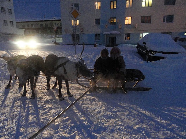
 Winter night
 Main article: List of twin towns and sister cities in Russia
Twin towns/sister cities
Salekhard is twinned with:
- Azov, Rostov Oblast, Russia
External links
- Official website of Salekhard
- (English) Information at the official website of Yamalo-Nenets Autonomous Okrug
References
- ^ a b c История города Салехард (in Russian). Retrieved 2010-12-06.
- ^ a b Федеральная служба государственной статистики (Federal State Statistics Service) (2011). "Предварительные итоги Всероссийской переписи населения 2010 года (Preliminary results of the 2010 All-Russian Population Census)" (in Russian). Всероссийская перепись населения 2010 года (All-Russia Population Census of 2010). Federal State Statistics Service. http://www.perepis-2010.ru/results_of_the_census/results-inform.php. Retrieved 2011-04-25.
- ^ a b Федеральная служба государственной статистики (Federal State Statistics Service) (2004-05-21). "Численность населения России, субъектов Российской Федерации в составе федеральных округов, районов, городских поселений, сельских населённых пунктов – районных центров и сельских населённых пунктов с населением 3 тысячи и более человек (Population of Russia, its federal districts, federal subjects, districts, urban localities, rural localities—administrative centers, and rural localities with population of over 3,000)" (in Russian). Всероссийская перепись населения 2002 года (All-Russia Population Census of 2002). Federal State Statistics Service. http://www.perepis2002.ru/ct/doc/1_TOM_01_04.xls. Retrieved 2010-03-23.
- ^ Правительство Российской Федерации. Постановление №725 от 31 августа 2011 г. «О составе территорий, образующих каждую часовую зону, и порядке исчисления времени в часовых зонах, а также о признании утратившими силу отдельных Постановлений Правительства Российской Федерации». Вступил в силу по истечении 7 дней после дня официального опубликования. Опубликован: "Российская Газета", №197, 6 сентября 2011 г. (Government of the Russian Federation. Resolution #725 of August 31, 2011 On the Composition of the Territories Included into Each Time Zone and on the Procedures of Timekeeping in the Time Zones, as Well as on Abrogation of Several Resolutions of the Government of the Russian Federation. Effective as of after 7 days following the day of the official publication).
- ^ Телефонные коды городов (in Russian). Retrieved 2010-09-24.
- ^ "Всесоюзная перепись населения 1989 г. Численность наличного населения союзных и автономных республик, автономных областей и округов, краёв, областей, районов, городских поселений и сёл-райцентров. (All Union Population Census of 1989. Present population of union and autonomous republics, autonomous oblasts and okrugs, krais, oblasts, districts, urban settlements, and villages serving as district administrative centers.)" (in Russian). Всесоюзная перепись населения 1989 года (All-Union Population Census of 1989). Demoscope Weekly (website of the Institute of Demographics of the State University—Higher School of Economics. 1989. http://demoscope.ru/weekly/ssp/rus89_reg.php. Retrieved 2010-03-23.
- ^ 2010/2011 visitor Любовь
Cities and towns in Yamalo-Nenets Autonomous Okrug Administrative center: Salekhard
 Categories:
- Salekhard
- Populated places established in 1595
- Populated places of Arctic Russia


Wikimedia Foundation. 2010.