- Orenburg Oblast
-
Orenburg Oblast Оренбургская область (Russian) — Oblast — 
Flag
Coat of arms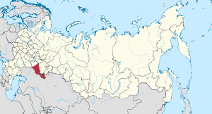
Coordinates: 52°08′N 55°36′E / 52.133°N 55.6°ECoordinates: 52°08′N 55°36′E / 52.133°N 55.6°E Political status Country Russia Federal district Volga[1] Economic region Urals[2] Established December 7, 1934 Administrative center Orenburg Government (as of March 2011) - Governor Yury Berg[3] - Legislature Legislative Assembly Statistics Area (as of the 2002 Census)[4] - Total 124,000 km2 (47,876.7 sq mi) Area rank 29th Population (2010 Census)[5] - Total 2,032,915 - Rank 23rd - Density 16.39 /km2 (42.4 /sq mi) - Urban 59.6% - Rural 40.4% Population (2002 Census)[6] - Total 2,179,551 - Rank 24th - Density 17.58 /km2 (45.5 /sq mi) - Urban 57.8% - Rural 42.2% Time zone(s) YEKST (UTC+06:00)[7] ISO 3166-2 RU-ORE License plates 56 Official languages Russian[8] http://www.orb.ru/ Orenburg Oblast (Russian: Оренбу́ргская о́бласть, Orenburgskaya oblast) is a federal subject of Russia (an oblast). Its administrative center is the city of Orenburg. From 1938 to 1957, it bore the name Chkalov Oblast (Чка́ловская о́бласть) in honor of Valery Chkalov. Population: 2,032,915 (2010 Census preliminary results).[5]
Contents
Geography
The most important river of the oblast is the Ural.
Orenburg is traversed by the northeasterly line of equal latitude and longitude.
Administrative divisions
Main article: Administrative divisions of Orenburg OblastDemographics
Population: 2,032,915 (2010 Census preliminary results);[5] 2,179,551 (2002 Census);[6] 2,174,459 (1989 Census).[9]
According to the 2002 Census, the national composition of the oblast was as follows:
- Russians: 73.9%
- Tatars: 7.6%
- Kazakhs: 5.8%
- Ukrainians: 3.5%
- Bashkirs: 2.4%
- Mordvinians: 2.4%
- Germans: 0.8%
- Chuvash: 0.8%
- Belarusians: 0.4%
- Azeris: 0.4%
- Uzbeks: 0.2%
- and many other groups, none more than 0.2% of the population.
- 0.13% of the population did not state their nationality in the census.
Religion
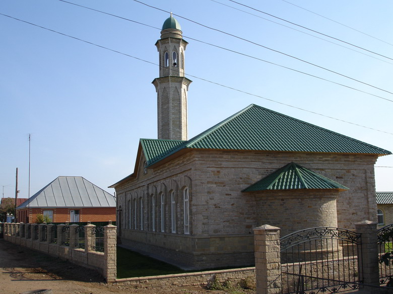
 A mosque in Orenburg Oblast
The main religion is Orthodox Christianity, while a large minority (about 16.4%) is Muslim.
Economy
Orenburg Oblast is one of the major agricultural areas of Russia. Its climate is favorable for farming: humid spring, dry summer and a large number of sunny days make perfect conditions for cultivating hard wheat and rye, sunflowers, potatoes, peas, beans, corn, and gourds.
The range of the oblast's export commodities includes: oil and oil products, gas and gas produced products, rolled ferrous and non-ferrous metals, nickel, asbestos, chromium compounds, rough copper, electric engines, radiators, products of machine-building industry.
References
- ^ Президент Российской Федерации. Указ №849 от 13 мая 2000 г. «О полномочном представителе Президента Российской Федерации в федеральном округе». Вступил в силу 13 мая 2000 г. Опубликован: "Собрание законодательства РФ", №20, ст. 2112, 15 мая 2000 г. (President of the Russian Federation. Decree #849 of May 13, 2000 On the Plenipotentiary Representative of the President of the Russian Federation in a Federal District. Effective as of May 13, 2000).
- ^ Госстандарт Российской Федерации. №ОК 024-95 27 декабря 1995 г. «Общероссийский классификатор экономических регионов. 2. Экономические районы», в ред. Изменения №5/2001 ОКЭР. (Gosstandart of the Russian Federation. #OK 024-95 December 27, 1995 Russian Classification of Economic Regions. 2. Economic Regions, as amended by the Amendment #5/2001 OKER. ).
- ^ Official website of Orenburg Oblast. Yury Alexandrovich Berg, Governor of Orenburg Oblast (Russian)
- ^ Федеральная служба государственной статистики (Federal State Statistics Service) (2004-05-21). "Территория, число районов, населённых пунктов и сельских администраций по субъектам Российской Федерации (Territory, Number of Districts, Inhabited Localities, and Rural Administration by Federal Subjects of the Russian Federation)" (in Russian). Всероссийская перепись населения 2002 года (All-Russia Population Census of 2002). Federal State Statistics Service. http://perepis2002.ru/ct/html/TOM_01_03.htm. Retrieved 2011-11-01.
- ^ a b c Федеральная служба государственной статистики (Federal State Statistics Service) (2011). "Предварительные итоги Всероссийской переписи населения 2010 года (Preliminary results of the 2010 All-Russian Population Census)" (in Russian). Всероссийская перепись населения 2010 года (All-Russia Population Census of 2010). Federal State Statistics Service. http://www.perepis-2010.ru/results_of_the_census/results-inform.php. Retrieved 2011-04-25.
- ^ a b Федеральная служба государственной статистики (Federal State Statistics Service) (2004-05-21). "Численность населения России, субъектов Российской Федерации в составе федеральных округов, районов, городских поселений, сельских населённых пунктов – районных центров и сельских населённых пунктов с населением 3 тысячи и более человек (Population of Russia, its federal districts, federal subjects, districts, urban localities, rural localities—administrative centers, and rural localities with population of over 3,000)" (in Russian). Всероссийская перепись населения 2002 года (All-Russia Population Census of 2002). Federal State Statistics Service. http://www.perepis2002.ru/ct/doc/1_TOM_01_04.xls. Retrieved 2010-03-23.
- ^ Правительство Российской Федерации. Постановление №725 от 31 августа 2011 г. «О составе территорий, образующих каждую часовую зону, и порядке исчисления времени в часовых зонах, а также о признании утратившими силу отдельных Постановлений Правительства Российской Федерации». Вступил в силу по истечении 7 дней после дня официального опубликования. Опубликован: "Российская Газета", №197, 6 сентября 2011 г. (Government of the Russian Federation. Resolution #725 of August 31, 2011 On the Composition of the Territories Included into Each Time Zone and on the Procedures of Timekeeping in the Time Zones, as Well as on Abrogation of Several Resolutions of the Government of the Russian Federation. Effective as of after 7 days following the day of the official publication).
- ^ Official the whole territory of Russia according to Article 68.1 of the Constitution of Russia.
- ^ "Всесоюзная перепись населения 1989 г. Численность наличного населения союзных и автономных республик, автономных областей и округов, краёв, областей, районов, городских поселений и сёл-райцентров. (All Union Population Census of 1989. Present population of union and autonomous republics, autonomous oblasts and okrugs, krais, oblasts, districts, urban settlements, and villages serving as district administrative centers.)" (in Russian). Всесоюзная перепись населения 1989 года (All-Union Population Census of 1989). Demoscope Weekly (website of the Institute of Demographics of the State University—Higher School of Economics. 1989. http://demoscope.ru/weekly/ssp/rus89_reg.php. Retrieved 2010-03-23.
Categories:- Orenburg Oblast
- States and territories established in 1934


Wikimedia Foundation. 2010.