- Altai Republic
-
Altai Republic Республика Алтай (Russian)
Алтай Республика (Altay)— Republic — 
Flag
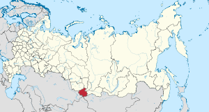
Coat of armsAnthem: National Anthem of the Altai Republic Coordinates: 50°55′N 86°55′E / 50.917°N 86.917°ECoordinates: 50°55′N 86°55′E / 50.917°N 86.917°E Political status Country Russia Federal district Siberian[1] Economic region West Siberian[2] Established July 1, 1922 Capital Gorno-Altaysk Government (as of September 2010) - Head[3] Alexander Berdnikov[4] - Legislature State Assembly—El Kurultai[3] Statistics Area (as of the 2002 Census)[5] - Total 92,600 km2 (35,753.1 sq mi) Area rank 35th Population (2010 Census)[6] - Total 206,195 - Rank 79th - Density 2.23 /km2 (5.8 /sq mi) - Urban 27.6% - Rural 72.4% Population (2002 Census)[7] - Total 202,947 - Rank 79th - Density 2.19 /km2 (5.7 /sq mi) - Urban 26.4% - Rural 73.6% Time zone(s) OMSST (UTC+07:00)[8] ISO 3166-2 RU-AL License plates 04 Official languages Russian;[9] Altay[10] http://www.altai-republic.ru Altai Republic (Russian: Респу́блика Алта́й, Respublika Altay; Altay: Алтай Республика, Altay Respublika) is a federal subject of Russia (a republic). Its capital is the town of Gorno-Altaysk. The area of the republic is 92,600 square kilometers (35,800 sq mi). Population: 206,195 (2010 Census preliminary results).[6]
Contents
Geography
See also: Geography of South-Central SiberiaThe republic is situated in the very center of Asia at the junction of Siberian taiga, steppes of Kazakhstan and semi-deserts of Mongolia. Forests cover about 25% of the republic's territory.
- Area: 92,600 km2 (35,800 sq mi)
- Borders:
- internal: Kemerovo Oblast (N), Republic of Khakassia (NE), Tuva Republic (E), and Altai Krai (W/NW).
- international: Mongolia (Bayan-Ölgii Province) (SE), China (Altay Prefecture) (S), and Kazakhstan (East Kazakhstan Province) (S/SW)
- Highest point: Mount Belukha (4,506 m)
- Maximum N->S distance: 360 km
- Maximum E->W distance: 380 km
Rivers and lakes
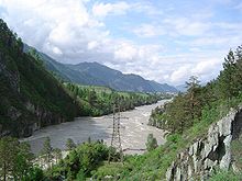
More than 20,000 tributaries sprawl throughout the mountainous Republic, making for a total of more than 60,000 kilometers (37,000 mi) worth of waterways. The republic's largest rivers are the Katun and the Biya, both of which originate in the mountains and flow northwards. The junction of the two rivers eventually forms the Ob River, one of the longest rivers in Siberia, which flows northward to the Arctic Ocean.
The source of the black Biya River is Lake Teletskoye, the region's largest lake located in an isolated area far south in the mountains. The emerald-colored Katun River has its source at the Gebler glacier, which is situated on the Republic's highest point, Mount Belukha. The Katun River in particular holds a religious significance for native Altaians, as well as for many Russians who live in the area, as Mount Belukha is known in Altai folklore to be the gateway to the mystical kingdom of Shambhala. [1]
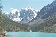
The hydrographic network of the Republic also includes approximately 7,000 lakes, adding up to a total area of more than 700 km2 (270 sq mi). The largest lake is Lake Teletskoye, which is 80 km (50 mi) long and 5 kilometers (3.1 mi) wide, has an area of 230.8 square kilometers (89.1 sq mi), and has a maximum depth of 325 meters (1,066 ft). The mountain lakes of Altai contain enormous freshwater reserves of a very pure quality as a result of their distance from most human activity. [2] Lake Teletskoye alone contains more than 40 cubic kilometers (9.6 cu mi) of highly pure water.
Potential ground water storage is evaluated at 22 million m³ per day, while the present use constitutes about 44,000 m³ per day.
Mountains
The most striking geographical aspect of the Republic of Altai is its mountainous terrain. The Republic is situated within the Russian part of the Altai Mountains system, which covers a large part of the Republic and continues into neighboring Kazakhstan, Mongolia and China. The region continues to experience periodic notable seismic activity, which is visually made apparent through the mountains' characteristically high and rugged mountain ridges, separated by narrow and deep river valleys. The Republic's highest peak, Mount Belukha (4,506 m), is the highest point in Siberia.
Natural resources
Various bodies of water are among the most important natural resources of the Republic. Mineral and hot springs are popular destinations for tourists and locals, sought for their therapeutic effects. Additionally, Altai glaciers contain a great amount of fresh water. The general volume of ice for registered Altai glaciers comes to a total of 57 km³, 52 km³ of which is water. The total water stock of the glaciers exceeds the average annual effluence of all Altai rivers, which are equal to 43 km³ per year. The largest glaciers are: Bolshoy Taldurinsky (35 km²), Mensu (21 km²), Sofiysky (17 km²), and Bolshoy Maashey (16 km²).
Mineral resources in the region primarily include gold, silver, iron ores, and lithium, in addition to other smaller amounts of minerals. The large city of Barnaul in neighboring Altai Krai was originally founded as a processing center for minerals from the Altai region, although the mineral extraction industry today is much smaller than in the past.
Climate
The republic has a temperate continental climate with relatively short and hot summers (June–August); and long, cold, and often quite frosty winters (November–March).
In general, the republic's climate of the southeastern areas, such as the (Ulagansky and Kosh-Agachsky Districts), is harsher than the climate of the less elevated northern areas.
- Average annual temperature: +1°C to -6.7°C.
- January temperature range: -9.2°C to -31°C.
- July temperature range: +11°C to +19°C.
- Average annual precipitation: 100–1000 mm.
Administrative divisions
Main article: Administrative divisions of the Altai RepublicDemographics
- Population: 206,195 (2010 Census preliminary results]])[6]
- Population: 202,947 (2002 Census)[7]
- Urban: 53,538 (26.4%)
- Rural: 149,409 (73.6%)
- Male: 96,572 (47.6%)
- Female: 106,375 (52.4%)
- Females per 1,000 males: 1,102
- Average age: 30.5 years
- Urban: 29.4 years
- Rural: 30.9 years
- Male: 29.0 years
- Female: 32.0 years
- Number of households: 69,004 (with 200,100 people)
- Urban: 19,864 (with 55,578 people)
- Rural: 49,140 (with 147,522 people)
- Vital statistics
Births Deaths Birth rate Death rate 1970 3,236 1,486 19.3 8.8 1975 3,805 1,724 22.4 10.1 1980 3,841 2,082 21.9 11.9 1985 4,256 2,097 23.0 11.3 1990 3,753 2,126 19.3 10.9 1991 3,579 2,064 18.2 10.5 1992 3,263 2,271 16.6 11.5 1993 2,878 2,630 14.6 13.4 1994 2,931 2,875 14.8 14.5 1995 2,853 2,637 14.3 13.2 1996 2,704 2,567 13.5 12.8 1997 2,686 2,547 13.4 12.7 1998 2,923 2,367 14.5 11.8 1999 2,742 2,536 13.6 12.6 2000 2,907 2,645 14.3 13.0 2001 3,033 2,870 14.9 14.1 2002 3,252 3,061 16.0 15.1 2003 3,392 3,173 16.7 15.6 2004 3,513 3,015 17.3 14.8 2005 3,502 3,170 17.2 15.5 2006 3,395 2,837 16.6 13.8 2007 4,066 2,574 19.7 12.5 2008 4,442 2,549 21.3 12.2 - Ethnic groups
As per the 2002 Census, ethnic Russians make up 57.4% of the republic's population, with the ethnic Altay people numbering only 30.6%. Other groups include Kazakhs (6.0%), Telengits (2,368, or 1.2%), Tubalars (1,533, or 0.8%), Ukrainians (1,437 or 0.7%), and a host of smaller groups, each accounting for less than 0.5% of the total population.
1926 census 1939 census 1959 census 1970 census 1979 census 1989 census 2002 census Altay 42,2131 (42.4%) 39,285 (24.2%) 38,019 (24.2%) 46,750 (27.8%) 50,203 (29.2%) 59,130 (31.0%) 67,7452 (33.5%) Russians 51,813 (52.0%) 114,209 (70.4%) 109,661 (69.8%) 110,442 (65.6%) 108,795 (63.2%) 115,188 (60.4%) 116,510 (57.4%) Kazakhs 2,326 (2.3%) 4,280 (2.6%) 4,745 (3.0%) 7,170 (4.3%) 8,677 (5.0%) 10,692 (5.6%) 12,108 (6.0%) Others 3,309 (3.3%) 4,405 (2.7%) 4,736 (3.0%) 3,899 (2.3%) 4,365 (2.5%) 5,821 (3.1%) 6,443 (3.2%) - including 3414 Telengits, 1384 Kumandins and 344 Teleuts
- including 2368 Telengits, 1533 Tubalars, 931 Kumandins, 830 Chelkans and 32 Teleuts
History
The national autonomy for the Altai people was created on June 1, 1922 as Oyrot Autonomous Oblast (Ойро́тская автоно́мная о́бласть), part of Altai Krai. The original name for this region was Bazla. On January 7, 1948 it was renamed Gorno-Altai Autonomous Oblast (Го́рно-Алта́йская автоно́мная о́бласть). In 1991 it was reorganized into the Gorno-Altai Autonomous Soviet Socialist Republic (ASSR). In 1992 it was renamed as the Altai Republic.
Politics
The head of government in Altai Republic is the Head of the Republic, popularly elected for a four-year term. As of 2006, the Head of the Republic is Alexander Vasilyevich Berdnikov, who succeeded Mikhail Lapshin in this post. The supreme legislative body of the republic is the State Assembly—El Kurultai, with 41 deputies popularly elected every four years. Igor Yaimov is the current Chairman of the State Assembly-El Kurultai from January 2002.
The Republic's Constitution was adopted on June 7, 1997.
Economy
The Altai Republic is a highly agricultural region. However, it does have some industry which includes foodstuffs, non-ferrous metallurgy, chemicals, gold mining, footwear, dairying and timber. Tourism has also begun to make its mark on the economy, and a large number of new hotels and resorts catering towards "New Russians" have begun to appear.
Transportation
Due to geographical peculiarities of the Republic, two means of transportation : Motor transport (over 90% of all kinds of traffic) and air transport (passenger traffic and transport of mail)—were developed. Motor transport is by far the prevailing one, and the vast majority of the Republic's inhabitants live along the main Chuiskiy highway. The extent of automobile roads is more than 3,500 kilometers (2,200 mi), 572 kilometers (355 mi) of which is the Chuiskiy, the route of Federal importance Novosibirsk-Biysk-Tashanta.
Tourism
With the Soviet Union's collapse, the Altai Republic's tourism industry has greatly expanded. Although wealthy Russians from neighboring Russian republics are the most common sort of tourist in Altai, foreign interest has also grown in the area, especially due to the area's spiritual significance to New Age believers and others.
Popular tourist destinations tend to be concentrated in the north, where the roads are more accessible. They are also almost entirely located along the Chuiskiy highway, which is the main road from the north into the mountains (although it is currently only two lanes wide). The north is also significantly warmer than the elevated southern areas, which tend to be chilly even in the summer.
Some of the more well-known tourist spots in the Altai region include Lake Aiya (a popular bathing spot), Belokurikha (known for its mineral water springs), and the picturesque Chemal region. More adventurous travelers may wish to visit the more remote Lake Teletskoye or Mount Belukha in the south.
Education
There is one university (Gorno-Altaisk State University), twelve colleges, and 205 secondary schools in the republic.
Religion
The traditional religion of the native Altaians is shamanism. Ethnic Russians primarily practice Orthodox Christianity, while Kazakhs are traditionally Muslims. Tibetan Buddhism has also recently begun making some inroads by way of neighboring Mongolia and Tuva.
From 1904 until the 1930s, a new religious movement called Burkhanism (or Ak Jang, the "white faith") was popularized among native Altaians. The religion originated in Altai, and emphasized the "white" aspect of shamanistic practice. Burkhanism remains an important component of Altaian national consciousness, and is currently being revived in several forms along with indigenous Altai culture in general.
Russian New Age followers often go on pilgrimages to Mount Belukha, which is considered to be the location of Shambhala both by some New Agers and locals of Altai. One can often find manifestations of shamanistic spirituality in the region; for example, at points along the Katun River, local believers in shamanism are known to tie white ribbons to nearby trees and leave offerings of coins or food to the spirits. [3] Although shamanism is much less widely practiced today, it is regaining popularity as a result of new religious freedom following the collapse of the Soviet Union.
Culture
Grigory Gurkin, born in 1870 in Ulala, was the first professional Altay artist. He is notable for his Altay landscapes.
See also
References
Notes
- ^ Президент Российской Федерации. Указ №849 от 13 мая 2000 г. «О полномочном представителе Президента Российской Федерации в федеральном округе». Вступил в силу 13 мая 2000 г. Опубликован: "Собрание законодательства РФ", №20, ст. 2112, 15 мая 2000 г. (President of the Russian Federation. Decree #849 of May 13, 2000 On the Plenipotentiary Representative of the President of the Russian Federation in a Federal District. Effective as of May 13, 2000).
- ^ Госстандарт Российской Федерации. №ОК 024-95 27 декабря 1995 г. «Общероссийский классификатор экономических регионов. 2. Экономические районы», в ред. Изменения №5/2001 ОКЭР. (Gosstandart of the Russian Federation. #OK 024-95 December 27, 1995 Russian Classification of Economic Regions. 2. Economic Regions, as amended by the Amendment #5/2001 OKER. ).
- ^ a b Constitution, Article 8
- ^ Official website of the Altai Republic. Biography of Alexander Vasilyevich Berdnikov
- ^ Федеральная служба государственной статистики (Federal State Statistics Service) (2004-05-21). "Территория, число районов, населённых пунктов и сельских администраций по субъектам Российской Федерации (Territory, Number of Districts, Inhabited Localities, and Rural Administration by Federal Subjects of the Russian Federation)" (in Russian). Всероссийская перепись населения 2002 года (All-Russia Population Census of 2002). Federal State Statistics Service. http://perepis2002.ru/ct/html/TOM_01_03.htm. Retrieved 2011-11-01.
- ^ a b c Федеральная служба государственной статистики (Federal State Statistics Service) (2011). "Предварительные итоги Всероссийской переписи населения 2010 года (Preliminary results of the 2010 All-Russian Population Census)" (in Russian). Всероссийская перепись населения 2010 года (All-Russia Population Census of 2010). Federal State Statistics Service. http://www.perepis-2010.ru/results_of_the_census/results-inform.php. Retrieved 2011-04-25.
- ^ a b Федеральная служба государственной статистики (Federal State Statistics Service) (2004-05-21). "Численность населения России, субъектов Российской Федерации в составе федеральных округов, районов, городских поселений, сельских населённых пунктов – районных центров и сельских населённых пунктов с населением 3 тысячи и более человек (Population of Russia, its federal districts, federal subjects, districts, urban localities, rural localities—administrative centers, and rural localities with population of over 3,000)" (in Russian). Всероссийская перепись населения 2002 года (All-Russia Population Census of 2002). Federal State Statistics Service. http://www.perepis2002.ru/ct/doc/1_TOM_01_04.xls. Retrieved 2010-03-23.
- ^ Правительство Российской Федерации. Постановление №725 от 31 августа 2011 г. «О составе территорий, образующих каждую часовую зону, и порядке исчисления времени в часовых зонах, а также о признании утратившими силу отдельных Постановлений Правительства Российской Федерации». Вступил в силу по истечении 7 дней после дня официального опубликования. Опубликован: "Российская Газета", №197, 6 сентября 2011 г. (Government of the Russian Federation. Resolution #725 of August 31, 2011 On the Composition of the Territories Included into Each Time Zone and on the Procedures of Timekeeping in the Time Zones, as Well as on Abrogation of Several Resolutions of the Government of the Russian Federation. Effective as of after 7 days following the day of the official publication).
- ^ Official the whole territory of Russia according to Article 68.1 of the Constitution of Russia.
- ^ Constitution, Article 13
Sources
- 7 июня 1997 г. «Конституция Республики Алтай (Основной Закон)», в ред. Конституционного закона №5-КРЗ от 27 ноября 2007 г. (June 7, 1997 Constitution of the Altai Republic (Basic Law), as amended by the Constitutional Law #5-KRZ of November 27, 2007. ).
External links
- (English) Official website of the Altai Republic
- (Russian) Official website of the Altai Republic
- National anthem of the Altai Republic (mp3)
- (Russian) (English) Gorno-Altaisk State University
- (German) Altai-Portal
- (English) United Nations University digital video (2009) "Rediscovering Altai's human-nature relationships - Russia": a Telengit community leader and shaman from the Russian Altai’s high altitude Kosh Agach Raion traversing Altai’s sacred lands Accessed 1 December 2009
- (Russian) Photos of Mountain Altai - Altai-Photo
Subdivisions of Russia Republics Krais Oblasts - Amur
- Arkhangelsk
- Astrakhan
- Belgorod
- Bryansk
- Chelyabinsk
- Irkutsk
- Ivanovo
- Kaliningrad
- Kaluga
- Kemerovo
- Kirov
- Kostroma
- Kurgan
- Kursk
- Leningrad
- Lipetsk
- Magadan
- Moscow
- Murmansk
- Nizhny Novgorod
- Novgorod
- Novosibirsk
- Omsk
- Orenburg
- Oryol
- Penza
- Pskov
- Rostov
- Ryazan
- Sakhalin
- Samara
- Saratov
- Smolensk
- Sverdlovsk
- Tambov
- Tomsk
- Tula
- Tver
- Tyumen
- Ulyanovsk
- Vladimir
- Volgograd
- Vologda
- Voronezh
- Yaroslavl
Federal cities Autonomous oblasts Autonomous okrugs 1administratively subordinated to Tyumen Oblast 2 administratively subordinated to Arkhangelsk Oblast
Turkic-speaking regions Federal subjects of Russia shown in italics.Western Turkic
 Azerbaijan1
 Bashkortostan
 Chuvashia
 Northern Cyprus
 Gagauzia (Moldova)
 Kabardino-Balkaria
 Karachay-Cherkessia
 Karakalpakstan (Uzbekistan)
 Turkmenistan
 Uzbekistan
 Xinjiang (China)1 Includes the Nakhchivan Autonomous Republic.Categories:
- Altai Republic
- States and territories established in 1922
- Turkic peoples
Wikimedia Foundation. 2010.


