- Wrangel Island
-
For the Alaskan island, see Wrangell Island.
Natural System of Wrangel Island Reserve * UNESCO World Heritage Site
Country  Russian Federation
Type Natural Criteria ix, x Reference 1023 Region ** List of World Heritage Sites in Asia Inscription history Inscription 2004 (28th Session) * Name as inscribed on World Heritage List
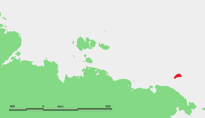
** Region as classified by UNESCOWrangel Island (Russian: о́стров Вра́нгеля, ostrov Vrangelya) is an island in the Arctic Ocean, between the Chukchi Sea and East Siberian Sea. Wrangel Island lies astride the 180° meridian. The International Date Line is displaced eastwards at this latitude to avoid the island as well as the Chukchi Peninsula on the Russian mainland. The closest land to Wrangel Island is tiny and rocky Herald Island located 60 km (37 mi) to the east.[1]
Nearly all of Wrangel Island, and Herald Island, are a federally protected nature sanctuary administered by Russia's Ministry of Natural Resources. The island, and their surrounding waters, were classified as a "Zapovednik" (a "strict nature reserve") in 1976 and, as such, receive the highest level of protection and excludes practically all human activity other than for scientific purposes. The Chukotka Regional government extended the marine protected area out to 24 nautical miles in 1999. As of 2003, there were four rangers who reside on the island year-round. In addition a core of about 12 scientists conduct research during the summer months.
Wrangel Island is about 125 km (78 mi) wide and 7,600 km2 (2,900 sq mi) in area. It consists of a southern coastal plain that is as wide as 15 km (9.3 mi); a central belt of low-relief mountains; and a northern coastal plain that is as wide as 25 km (16 mi). The east-west trending central mountain belt, the Tsentral'nye Mountain Range, is as much as 40 km (25 mi) wide and 145 km (90 mi) long from coast to coast. Typically, the mountains are a little over 500 m (1,600 ft) above mean sea level. The highest mountain on this island is Sovetskaya Mountain with an elevation of 1,096 m (3,596 ft) above mean sea level. The east-west trending mountain range terminates at sea cliffs at either end of the island.[1]
Wrangel Island belongs administratively to the Chukotka Autonomous Okrug of the Russian Federation. This rocky island has a weather station and two permanent Chukchi fishing settlements on the southern side of the island (Ushakovskoye[1] and Zvyozdny on the shore of Somnitelnaya Bay[2]).
Contents
Geology
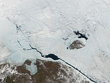 True colour MODIS photograph of Wrangel Island, taken in 2001
Wrangel Island consists of folded, faulted, and metamorphosed volcanic, intrusive, and sedimentary rocks ranging in age from Upper Precambrian to Lower Mesozoic. The Precambrian rocks, which are about 2 km (1.2 mi) thick, consist of Upper Proterozoic sericite and chlorite slate and schist that contain minor amounts of metavolcanic rocks, metaconglomerates, and quartzite. These rocks are intruded by metamorphosed gabbro, diabase, and felsic dikes and sills and granite intrusions. Overlying the Precambrian strata are up to 2.25 km (1.4 mi) of Upper Silurian to Lower Carboniferous consisting of interbedded sandstone, siltstone, slate, argillite, some conglomerate and rare limestone and dolomite. These strata are overlain by up to 2.15 km (1.34 mi) of Carboniferous to Permian limestone, often composed largely of crinoid plates, that is interbedded with slate, argillite and locally minor amounts of thick breccia, sandstone, and chert. The uppermost stratum consists of 0.7 to 1.5 km (0.43 to 0.93 mi) of Triassic clayey quartzose turbidites interbedded with black slate and siltstone.[1]
A thin veneer of Cenozoic gravel, sand, clay and mud underlie the coastal plains of Wrangel Island. Late Neogene clay and gravel, which are only a few tens of meters thick, rest upon the eroded surface of the folded and faulted strata that comprise Wrangel Island. Indurated Pliocene mud and gravel, which are only a few meters thick, overlie the Late Neogene sediments. Sandy Pleistocene sediments occur as fluvial sediments along rivers and streams and as a very thin and patchy surficial layer of either colluvium or eluvium.[1]
Fauna and flora
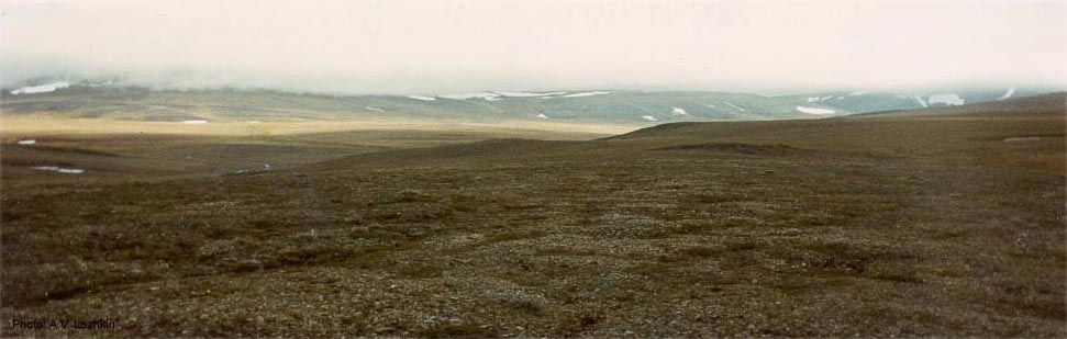
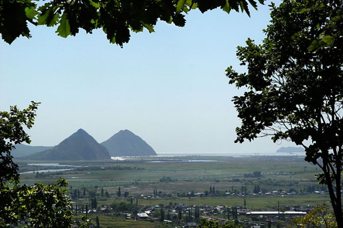
 Arctic tundra on Wrangel Island
Wrangel Island is a breeding ground for polar bears (having the highest density of dens in the world), seals, walrus, and lemmings. During the summer it is visited by many types of birds. Arctic fox also make their home on the island.
Woolly mammoths survived there until 1650 BC, the most recent survival of all known mammoth populations.[3][4][5] However, due to limited food supply, they were much smaller in size than typical mammoths.[6] Domestic reindeer were introduced in the 1950s and their numbers are managed at around 1,000 in order to reduce their impact on nesting bird grounds. In 1975 musk ox were also introduced. The population has grown from 20 to about 200 animals. Recently, Arctic Wolf have been spotted on the island; wolves have lived on the island in historical times but previous packs were eradicated to reduce predation on reindeer and musk ox.[7]
The flora includes 417 species of plants, double that of any other Arctic tundra territory of comparable size and more than any other Arctic island. For these reasons, the island was proclaimed the northernmost World Heritage Site in 2004.
Climate
Wrangel Island has a severe polar climate. The region is blanketed by dry and cold Arctic air masses for most of the year. Warmer and more humid air can reach the island from the south-east during summer. Dry and heated air from Siberia comes to the island periodically.
Wrangel Island is influenced by both the Arctic and Pacific air masses. One consequence is the predominance of high winds. The island is subjected to “cyclonic” episodes characterized by rapid circular winds. It is also an island of mists and fogs.
Winters are prolonged and are characterized by steady frosty weather and high northerly winds. During this period the temperatures usually stay well below freezing for months. In February and March there are frequent snow-storms with wind speeds of 140 km/h (87 mph) or above.
There are noticeable differences in climate between the northern, central and southern parts of the island. The central and southern portion is warmer, with some of the valleys having semi-continental climates that support a number sub-Arctic steppe-like meadow species. This is a unique feature in the High Arctic.
The short summers are cool but comparatively mild as the polar day generally keeps temperatures above 0 °C (32 °F). Some frosts and snowfalls occur, and fog is common. Warmer and drier weather are experienced in the center of the island because the interior's topography encourages foehn winds. As of 2003, the frost-free period on the island was very short, usually not more than 20-to-25 days, and more often only two weeks.
Average relative humidity is about 82%.
Climate data for Wrangel Island Month Jan Feb Mar Apr May Jun Jul Aug Sep Oct Nov Dec Year Record high °C (°F) 1.5
(34.7)−0.2
(31.6)0.7
(33.3)2.2
(36.0)11.1
(52.0)17.4
(63.3)18.2
(64.8)16.7
(62.1)11.9
(53.4)5.3
(41.5)1.7
(35.1)1.1
(34.0)18.2
(64.8)Average high °C (°F) −19.2
(−2.6)−21.1
(−6.0)−19.8
(−3.6)−13.3
(8.1)−4.1
(24.6)3
(37)5.3
(41.5)4.5
(40.1)0.8
(33.4)−5.4
(22.3)−11.9
(10.6)−18.1
(−0.6)−8.2 Average low °C (°F) −26.7
(−16.1)−28.6
(−19.5)−27.6
(−17.7)−21.2
(−6.2)−9.8
(14.4)−1.5
(29.3)0.6
(33.1)0.2
(32.4)−2.9
(26.8)−10.2
(13.6)−18
(0)−24.7
(−12.5)−14.2 Record low °C (°F) −42
(−44)−44.6
(−48.3)−45
(−49)−38.2
(−36.8)−31.5
(−24.7)−12.3
(9.9)−4.9
(23.2)−6.5
(20.3)−21.4
(−6.5)−29.8
(−21.6)−34.9
(−30.8)−57.7
(−71.9)−57.7
(−71.9)Precipitation mm (inches) 16
(0.63)9
(0.35)9
(0.35)8
(0.31)8
(0.31)13
(0.51)23
(0.91)28
(1.1)22
(0.87)15
(0.59)17
(0.67)11
(0.43)179
(7.05)Source: Климат о. Врангеля[8] Waters On and Around Wrangel
According to a 2003 report prepared by the Wrangel Island Nature Preserve, the hydrographic network of Wrangel Island consists of approximately 1,400 rivers over 1 kilometer in length; five rivers over 50 kilometres (31.07 mi) long; and approximately 900 shallow lakes, mostly located in the northern portion of Wrangel Island with a total surface area of 80 square kilometers. The waters of the East Siberian Sea and the Sea of Chukchi surrounding Wrangel and Herald Islands are classified as a separate chemical oceanographic region. These waters have among the lowest levels of salinity in the Arctic basin as well as a very high oxygen content and increased biogenic elements.
History
Prehistory
This remote Arctic island is believed to be the final place on Earth to support woolly mammoths as an isolated population until their extinction about 2000 BC, making them the most recent surviving population known to science.[6][9] A specific variant of the species seems to have survived as a dwarf version of the species originating from Siberia. A combination of late climate change (warming) and the presence of modern humans using advanced hunting and survival skills probably hastened their demise on this frozen isle which until recently was ice bound for most years with infrequent breaks of clear water in some Arctic summers. A mirror development can be found with the Dwarf elephant on Malta, originating from the African species.
Evidence for prehistoric human occupation was uncovered in 1975 at the Chertov Ovrag site.[10] Various stone and ivory tools were found, including a toggling harpoon. Radiocarbon dating shows the human inhabitation roughly coeval with the last mammoths on the island circa 1700 BC, though no direct evidence of mammoth hunting has been found.
Paleoeskimos people established camps on the southern side of the island for marine hunters. By the time Wrangel Island was discovered by Europeans there was no aboriginal population.
A legend prevalent among the Chukchi people of Siberia tells of a chief Krachai (or Krächoj, Krahay, Khrakhai), who fled with his people (the Krachaians or Krahays, also identified as the Onkilon or Omoki--Siberian Yupik people) across the ice to settle in a northern land.[11][12] Though the story may be mythical, the existence of an island or continent to the north was lent credence by the annual migration of reindeer across the ice, as well as the appearance of slate spear-points washed up on Arctic shores, made in a fashion unknown to the Chukchi. Michael E. Krauss has recently presented archaeological, historical, and linguistic evidence that Wrangel Island was a way station on a trade route linking the Inuit settlement at Point Hope, Alaska with the north Siberian coast, and that the coast may have been colonized in late prehistoric and early historic times by Inuit settlers from North America. Krauss suggests that the departure of these colonists was related to the Krachai legend.[13]
Outside discovery
In 1764 the Cossack Sergeant Stepan Andreyev claimed to have sighted this island. Calling it Tikegen Land, Andreyev found evidence of its inhabitants, the Krahay. Eventually, the island was named after Baron Ferdinand von Wrangel (1797–1870), who, after reading Andreyev's report and hearing Chukchi stories of land at the island's coordinates, set off on an expedition (1820–1824) to discover the island, with no success.[14]
British, American, and Russian expeditions
In 1849, Henry Kellett, captain of HMS Herald, landed on and named Herald Island. He thought he saw another island to the west, which he called Plover Island; thereafter it was indicated on British admiralty charts as Kellett Land.
The first recorded landing on the island was in 1866 by a German whaler, Eduard Dallmann.[15]
In August 1867, Thomas Long, an American whaling captain, "approached it as near as fifteen miles. I have named this northern land Wrangell [sic] Land … as an appropriate tribute to the memory of a man who spent three consecutive years north of latitude 68°, and demonstrated the problem of this open polar sea forty-five years ago, although others of much later date have endeavored to claim the merit of this discovery."
 Sketch of Wrangel Island as it appeared from the top of Herald Island, 1881
 Map of Wrangel Island produced by the USS Rodgers Survey, as reproduced in John Muir's Cruise of the Corwin
George W. DeLong, commanding USS Jeannette, led an expedition in 1879 attempting to reach the North Pole, expecting to go by the "east side of Kellett land," which he thought extended far into the Arctic. His ship became locked in the polar ice pack and drifted westward, passing within sight of Wrangel before being crushed and sunk in the vicinity of the New Siberian Islands. A landing on Wrangel Island took place on August 12, 1881, by a party from the USRC Corwin, who claimed the island for the United States and named it "New Columbia."[16] The expedition, under the command of Calvin L. Hooper, was seeking the Jeannette and two missing whalers in addition to conducting general exploration. It included naturalist John Muir, who published the first description of Wrangel Island. The USS Rodgers, also searching for the Jeannette, landed a party on Wrangel Island, also in 1881 but after the Corwin party. They stayed about two weeks and conducted an extensive survey and search.
In 1911, the Russian Arctic Ocean Hydrographic Expedition on icebreakers Vaygach and Taymyr under Boris Vilkitsky, landed on the island.[17] In 1916 the Tsarist government declared that the island belonged to the Russian empire.
Stefansson expeditions
In 1914, members of the ill-equipped Canadian Arctic Expedition, organized by Vilhjalmur Stefansson, were marooned on Wrangel Island for nine months after their ship, the Karluk, was crushed in the ice pack.[18] The survivors were rescued by the American motorized fishing schooner King & Winge[19] after Captain Robert Bartlett walked across the Chukchi Sea to Siberia to summon help.
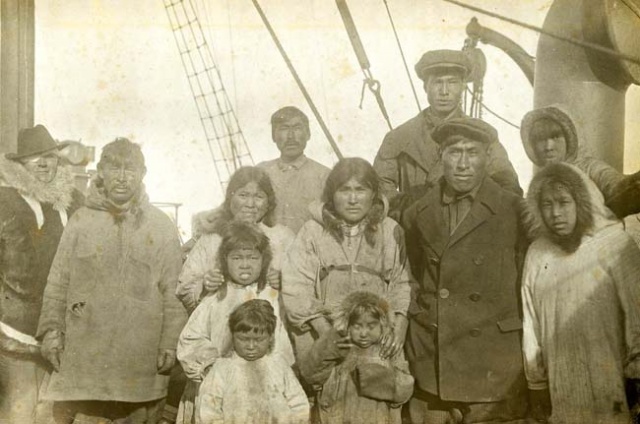
 Wrangel Island Inhabitants on board Krasnyj Oktiabr 1924
In 1921, Stefansson sent five settlers (the Canadian Allan Crawford, three Americans: Fred Maurer, Lorne Knight and Milton Galle, and Eskimo seamstress and cook Ada Blackjack) to the island in a speculative attempt to claim it for Canada.[20] The explorers were handpicked by Stefansson based upon their previous experience and academic credentials. Stefansson considered those with advanced knowledge in the fields of geography and science for this expedition. At the time, Stefansson claimed that his purpose was to head off a possible Japanese claim.[21] An attempt to relieve this group in 1922 failed when the schooner Teddy Bear under Captain Joe Bernard became stuck in the ice [22]. In 1923, the sole survivor of the Wrangel Island expedition, Ada Blackjack, was rescued by a ship that left another party of 13 (American Charles Wells and 12 Inuit). In 1924, the Soviet Union removed the American and the 13 Inuit (one was born on the island) of this settlement aboard the Krasny Oktiabr. Wells subsequently died of pneumonia in Vladivostok during a diplomatic American-Soviet row about an American boundary marker on the Siberian coast, and so did an Inuit child. The others were deported from Vladivostok to the Chinese border post Suifenhe, but the Chinese government didn't want to accept them as the American consul in Darbin told them the Inuit were not American citizens. Later the American government came up with a statement that the Inuit were 'wards' of the United States, but that there were no funds for returning them. Eventually the American Red Cross came up with $1600 for their return. They subsequently moved through Darwin, Darien, Kobe and Seattle (where another Inuit child drowned during the wait for the return trip to Alaska) back to Nome.[23] During the Soviet trip the American reindeer owner Carl J. Lomen from Nome had taken over the possessions of Stefansson and had acquired explicit support ("go and hold it") from US Secretary of State Charles Evans Hughes to claim the island for the United States,[24] a goal which the Russian expedition got to hear during their trip. Loman dispatched the MS Herman, commanded by captain Louis L. Lane. Due to unfavorable ice conditions the Herman could not get any further than Herald Island, where the American flag was raised.[25]
In 1926, the government of the Soviet Union reaffirmed the Tsarist claim to sovereignty over Wrangel Island.
Soviet rule
In 1926, a team of Soviet explorers, equipped with three years of supplies, landed on Wrangel Island. Clear waters that facilitated the 1926 landing were followed by years of continuous heavy ice surrounding the island. Attempts to reach the island by sea failed and it was feared that the team would not survive their fourth winter.[26]
In 1929, the icebreaker Fyodor Litke was chosen for a rescue operation. It sailed from Sevastopol, commanded by captain Konstantin Dublitsky. On July 4, it reached Vladivostok where all Black Sea sailors were replaced by local crew members. Ten days later Litke sailed north; it passed Bering Strait, and tried to pass De Long Strait and approach the island from south. On August 8 a scout plane reported impassable ice in the strait, and Litke turned north, heading to Herald Island. It failed to escape mounting ice; August 12 the captain shut down the engines to save coal and had to wait two weeks until the ice pressure eased. Making a few hundred meters a day, Litke reached the settlement August 28. On September 5, Litke turned back, taking all the 'islanders' to safety. This operation earned Litke the order of the Red Banner of Labour (January 20, 1930), as well as commemorative badges for the crew.
According to a 1936 article in Time Magazine Wrangel Island became the scene of a bizarre criminal story in the 1930s when it fell under the increasingly arbitrary rule of its appointed governor Konstantin Semenchuk. Semenchuk controlled the local populace and his own staff through open extortion and murder. He forbade the local Eskimos (recruited from Provideniya Bay in 1926)[27] to hunt walrus, which put them in danger of starvation, while collecting food for himself. He was then implicated in the mysterious deaths of some of his opponents, including the local doctor. The subsequent Moscow trial in June 1936 sentenced Semenchuk to death for "banditry" and violation of Soviet law.[28]
In 1948, a small herd of domestic reindeer was introduced with the intention of establishing commercial herding to generate income for island residents.
A prisoner who later emigrated to Israel, Efim Moshinsky, claims to have seen Raoul Wallenberg there in 1962.[29][30] However, despite the legends, there never was a Gulag camp on Wrangel.[31]
Aside from the main settlement of Ushakovskoye near Rogers Bay, on the south-central coast, in the 1960s, a new settlement named Zvyozndy was established to the west in the Somnitelnaya Bay area, where ground runways reserved for military aviation purposes were constructed (these were abandoned in the 1970s). Moreover, a military radar installation was built on the southeast coast at Cape Hawaii. Rock crystal mining had been carried out for a number of years in the center of the island near Khrustalnyi Creek. At the time, a small settlement, Perkatkun, had been established nearby to house the miners, but later on it was completely destroyed.
Establishment of Federal Nature Reserve
Resolution #189 of the Council of Ministers of the Russian Soviet Federative Socialist Republic (RSFSR) was adopted on March 23, 1976, for the establishment of the state Nature Reserve “Wrangel Island” for the purpose of conserving the unique natural systems of Wrangel and Herald Islands, a the surrounding waters out to five nautical miles. On 15 December 1997, the Russian Government's Decree No. 1623-r expanded the marine reserve out to 12 nautical miles. And on 25 May 1999, the (regional) Governor of Chukotka issued Decree No. 91 which again expanded the protected water area to 24 nautical miles around Wrangel and Herald Islands.
By the 1980s, the reindeer-herding farm on Wrangel had been abolished and the settlement of Zvezdnyi was virtually abandoned. Hunting had already been stopped, except for a small quota of marine mammals for the needs of the local population. In 1992, the military radar installation at Cape Hawaii (on the southeast coast) was closed and only the settlement of Ushakivskoe remained occupied on the island.
Post-Soviet era
According to some US individuals, including the group State Department Watch,[32] eight Arctic islands currently controlled by Russia, including Wrangel Island, are claimed by the United States. However, according to the United States Department of State[33] no such claim exists. The USSR/USA Maritime Boundary Treaty,[34] which has yet to be approved by the Russian Duma, does not address the status of these islands nor the martime boundaries associated with them.
In 2004 Wrangel Island and neighboring Herald Island, along with their surrounding waters, were added to UNESCO's World Heritage List.[35]
Tourism On Wrangel
Tourism is primarily by cruise ship and is subject to permits, as well as strict regulations and access criteria. Ships anchor near the island and disembark passengers who roam along the shores outside the Nature Reserve but do not enter the Reserve itself. Tourism into the Reserve is tightly controlled and includes scientific expeditions led by Reserve staff. This is a source of revenue for the Reserve and a means of promoting the Reserve’s values. The facilities on the island are primitive. The Reserve is dependent on oil and diesel generators for all of its energy.
The polar weather station and village of Ushakovskoe, with its surrounding non-Reserve buffer zone lying just outside the Nature Reserve poses the greatest immediate threat to the Reserve. Present day human impact within the Reserve is minimal. According to a 2003 report prepared by the Nature Reserve staff, there has already been environmental damage from the 80-plus years of settlement at Ushakovskoe. For instance, the staff at the polar weather station are rotational and their behaviour is not always sensitive to the vulnerabilities of the island. The Reserve rangers currently spend much of their time observing the activities at Ushakovskoe to minimize environmental damage. The Reserve staff do not have patrol boats and the threat of unauthorized fishing and poaching is always a serious threat.
In literature
In Jules Verne's novel César Cascabel, the protagonists float past Wrangel Island on an iceberg. In Verne's description, a live volcano is located on the island: "Between the two capes on its southern coast, Cape Hawan and Cape Thomas, it is surmounted by a live volcano, which is marked on the recent maps."[36] In Chukchi author Yuri Rytkheu's historical novel A Dream in Polar Fog, set in the 20th century, the Chukchi knew of Wrangel Island and referred to it as the"Invisible Land."[37]
See also
References
- ^ a b c d e Kos,ko, M.K., M.P. Cecile, J.C. Harrison, V.G. Ganelin, N.V., Khandoshko, and B.G. Lopatin, 1993, Geology of Wrangel Island, Between Chukchi and East Siberian Seas, Northeastern Russia. Bulletin 461, Geological Survey of Canada, Ottawa Ontario, 101 pp.
- ^ Ministry of Natural Resources of the russian Federation - History of Wrangel Island
- ^ Kh. A. Arslanov, G. T. Cook, Steinar Gulliksen, D.D. Harkness, Touvi Kankainen, E. M. Scott, Sergey Vartanyan, and Ganna I. Zaitseva, S. L. Vartanyan, “Consensus Dating of Remains from Wrangel Island”, Radiocarbon, Volume 40, Number 1, (Tucson: Radiocarbon, 1998), 289-294.
- ^ Sergei L. Vartanyan, Alexei N. Tikhonov, and Lyobov A. Orlova, “The Dynamic of Mammoth Distribution in the Last Refugia in Beringia”, Second World of Elephants Congress, (Hot Springs: Mammoth Site, 2005), 195.
- ^ Vartanyan, S.L.; Kh. A. Arslanov; T. V. Tertychnaya; S. B. Chernov (1995). "Radiocarbon Dating Evidence for Mammoths on Wrangel Island, Arctic Ocean, until 2000 BC". Radiocarbon (Department of Geosciences, The University of Arizona) 37 (1): pp 1–6. http://packrat.aml.arizona.edu/Journal/v37n1/vartanyan.html. Retrieved 2008-01-10.
- ^ a b Vartanyan, S. L.; Garutt, V. E.; Sher, A. V. (1993). "Holocene dwarf mammoths from Wrangel Island in the Siberian Arctic". Nature 362 (6418): 337–349. doi:10.1038/362337a0.
- ^ Natural System of Wrangel Island Reserve Chukotka, Russian Federation, United Nations Environment Program, World Conservation Monitoring Centre. March 2001; last updated March 2005. Accessed 30 July 2010.
- ^ "Климат о. Врангеля" (in Russian). Archived from the original on May 5, 2008. http://web.archive.org/web/20080505013951/http://pogoda.ru.net/climate/21982.htm. Retrieved August 2, 2008.
- ^ Vartanyan, S. L.; et al. (1995). "Radiocarbon Dating Evidence for Mammoths on Wrangel Island, Arctic Ocean, until 2000 BC". Radiocarbon 37 (1): 1–6. ISSN 00338222. http://packrat.aml.arizona.edu/Journal/v37n1/vartanyan.html.
- ^ Dikov, N. N. (1988). "The Earliest Sea Mammal Hunters of Wrangell Island". Arctic Anthropology 25 (1): 80–93.
- ^ Nordenskiöld, Adolf Erik (1881). The voyage of the Vega round Asia and Europe: with a historical review of previous journeys along the north coast of the old world. trans. by Alexander Leslie. London: Macmillan. pp. 443–448. http://books.google.com/?id=2nF-AAAAMAAJ.
- ^ Rink, Signe (1905). "A Comparative Study of Two Indian and Eskimo Legends". Proceedings of the International Congress of Americanists: 280. http://books.google.com/?id=FcViAAAAMAAJ&pg=PA280.
- ^ Krauss, Michael E. (2005) Eskimo languages in Asia, 1791 on, and the Wrangel Island-Point Hope connection Études/Inuit/Studies, vol. 29 (1-2), 2005, pp 163-185.
- ^ Von Wrangel, Ferdinand Petrovich (1840). Narrative of an expedition to the polar sea, in 1820, 1821, 1822 & 1823. Edited by Major Edward Sabine. James Madden and Company, London. 465 pp.
- ^ Tammiksaar, E.; N.G. Sukhova and I.R. Stone (Sep 1999). "Hypothesis Versus Fact: August Petermann and Polar Research". Arctic 52 (3): 237–244. http://pubs.aina.ucalgary.ca/arctic/Arctic52-3-237.pdf.
- ^ Muir, John, 1917, The Cruise of the Corwin: Journal of the Arctic Expedition of 1881 in search of De Long and the Jeannette. Norman S. Berg, Dunwoody, Georgia. (John Muir's description of the 1881 exploration of Wrangel Island.)
- ^ Great Soviet Encyclopedia, entry on "Вайгач"
- ^ Niven, Jennifer, The Ice Master, The Doomed 1913 Voyage of the Karluk. Hyperion Books, New York, New York. 431 pp.
- ^ Newell, Gordon R., 1966, H.W. McCurdy Maritime History of the Pacific Northwest, Superior Publishing, Seattle, Washington, 242 pp.
- ^ Niven, Jennifer (2003). Ada Blackjack: A True Story Of Survival In The Arctic. Hyperion Books, New York, New York. 431 pp.
- ^ New York Times March 20, 1922
- ^ New York Times September 25, 1922
- ^ Kenney, Gerard "When Canada Invaded Russia" The Canadian Encyclopedia
- ^ Dudley-Rowley, Marilyn (1998) "The Outward Course of Empire The Hard, Cold Lessons from Euro-American Involvement in the Terrestrial Polar Regions" presented at the Founding Convention of the Mars Society, August 13–16, 1998, University of Colorado, Boulder, Colorado, USA
- ^ [1] polarpost.ru forum
- ^ Berkeley Daily Gazette Jan 29, 1929 p. 4 "Wrangel Island holds the fate of lost colony"
- ^ * Krupnik, Igor and Mikhail Chlenov (2007). The end of “Eskimo land”: Yupik relocation in Chukotka, 1958-1959 Études/Inuit/Studies 31 (1-2) pp 59–81
- ^ Anonymous, 1936, Crazy Governor. Time Magazine, vol. XXVI, no. 22, pp. ??-??. (June 1, 1936).
- ^ Rosenfeld, Harvey (2005). Raoul Wallenberg: The Mystery Lives On. iUniverse. p. 164. ISBN 0595355447. http://books.google.com/?id=eFDNcB4NGdQC.
- ^ Moshinsky, Efim (1987). Raoul Wallenberg Is Alive! The Amazing Autobiography of the KGB Officer Who Arrested Him In 1945. Jerusalem: Rescue Publishing.
- ^ Джекобсон М., Кокурин А. И., Кривенко С. В., Сигачев С. П., Смирнов М. Б., Филиппов С. Г., Шкапов Д. В. Система исправительно-трудовых лагерей в СССР. 1923-1960 / Составитель М. Б. Смирнов, Научные редакторы: Н. Г. Охотин, А. Б. Рогинский. — М.: Звенья, 1998.
- ^ Anonymous, 2008, Giveaway of 8 American Alaskan Islands and Vast Resource-Rich Seabeds to Russians. State Department Watch, Washington, D.C.
- ^ *Bureau of European and Eurasian Affairs, 2003, Status of Wrangel and Other Arctic Islands. U.S. Department of State, Washington, D.C. (Fact sheet on Wrangel Island).
- ^ US Department of State and USSR Minister of Foreign Affairs, 1990, 1990 USSR/USA Maritime Boundary Treaty. DOALOS/OLA - United Nations Delimitation Treaties Infobase, New York, New York.
- ^ First wave of new properties added to World Heritage List for 2004
- ^ Verne, Jules (1890). "Part 2, Chapter III: Adrift". Caesar Cascabel. trans. by A. Estoclet. New York: Cassell Publishing Company. http://en.wikisource.org/wiki/C%C3%A6sar_Cascabel/Part_2/Chapter_III.
- ^ Rytkheu, Yuri (2005). A Dream in Polar Fog. trans. by Ilona Yazhbin Chavasse. Brooklyn, NY: Archipelago Books. p. 8. ISBN 0-9778576-1-1. http://books.google.com/books?id=CN1pzb0K9v4C.
- Anonymous (1923). "Wrangel Island". The Geographical Journal (Blackwell Publishing) 62 (6): 440–444. doi:10.2307/1781170. JSTOR 1781170.
External links
- Adventure Associates, 2008, Polar Expeditions to the Far North. Sydney, Australia. (Icebreaker journey to Wrangel Island.)
- Anonymous, 2008, Wrangel Island. Oceandots.com (aerial image and description of Wrangel Island)
- Pictures from Wrangel Island., 2007.
- Bureau of European and Eurasian Affairs, 2003, Status of Wrangel and Other Arctic Islands. U.S. Department of State, Washington, D.C. (Fact sheet on Wrangel Island.)
- Eglin, Libby, 2000, Run For Wrangel. Tourist's account and photography.
- Eime, Roderick, nd, Wrangel Island: Isolation, Desolation and Tragedy. Comments about history and tourism of Wrangel Island.
- Gray, D., 2003, The story of the Canadian Arctic Expedition of 1913-1918. Virtual Museum of Canada, Canadian Museum of Civilization, Gatineau, Quebec. (Includes Loss of the Karluk and Wrangel Island)
- Gualtieri, L., nd, The Late Pleistocene Glacial and Sea Level History of Wrangel Island, Northeast Siberia. Quaternary Research Center, University of Washington. (Numerous comments, picture, papers, links, concerning various aspects of Wrangel Island)
- Detailed map of Wrangel Island
- McClanahan, A.J., nd, The Heroine of Wrangel Island. LitSite, Alaska. (Article about Ada Blackjack Johnson and Wrangel Island.)
- MacPhee, Ross, nd, Siberian Expedition to Wrangel Island. American Museum of Natural History, New York, New York. (Hunting mammoths on Wrangel Island)
- Muir, John, 1917, The Cruise of the Corwin: Journal of the Arctic Expedition of 1881 in search of De Long and the Jeannette. Norman S. Berg, Dunwoody, Georgia. John Muir's description of the 1881 exploration of Wrangel Island.}
- Natural Heritage Protection Fund, 2008, Wrangel Island. Moscow, Russian Federation. (Web page about the Wrangel Island World Heritage Site.)
- Rosse, I.C., 1883, The First Landing on Wrangel Island: With Some Remarks on the Northern Inhabitants. Journal of the American Geographical Society of New York. vol. 15, pp. 163–214. Text files from Project Gutenberg. (Also, available from JSTOR at http://www.jstor.org/pss/196541)
- Stefansson, Vilhjalmur, 1921, The friendly Arctic; the story of five years in polar regions G. P. Putnam's Sons, New York, New York, 319 pp.
- Vartanyan, S.L., Kh.A. Arslanov, T.V. Tertychnaya and S.B. Chernov, 1995, Radiocarbon Dating Evidence for Mammoths on Wrangel Island. Radiocarbon. vol. 37, no. 1, pp. 1–6.
- UNESCO World Heritage Committee, nd, Natural System of Wrangel Island Reserve. United Nations Educational, Scientific and Cultural Organization, New York, New York.
 Islands of the Chukchi SeaBig Diomede, Russia • Chamisso Island • Diomede Islands • Herald Island • Idlidlya Island • Karkarpko Island • Kasegaluk Lagoon Islands • Kolyuchin Island • Kosa Dvukh Pilotov • Little Diomede, US • Puffin Island • Sarichef Island • Seahorse Islands • Serykh Gusey Islands • Wrangel Island • Yuzhnyy Island Islands of the East Siberian Sea (Russian Arctic)Anzhu Islands • Ayon Island • Bennett Island • Bolshoy Fedorovskiy • Chengkuul • De Long Islands • Glavsevmorput Island • Bolshoy Lyakhovsky Island • Henrietta Island • Jeannette Island • Kolesovsky Island • Kolesovskaya Otmel • Kotelny • Krestovyy Island • Maly Lyakhovsky Island • Medvezhyi Islands • Mikhalkino • New Siberian Islands • Novaya Sibir • Ploskiy • Routan Islands • Ryyanranot • Shalaurova • Sukhornyy • Uparovskiy • Usun Ary • Vilkitsky • Vkhodnoy • Wrangel Island • Zhokhov Island World Heritage Sites in Russia by federal district

Central Church of the Ascension in Kolomenskoye · Moscow Kremlin and Red Square
Novodevichy Convent · Trinity Sergius Lavra
White Monuments of Vladimir and Suzdal · Historic Centre of Yaroslavl

Southern Northwestern Far Eastern Volcanoes of Kamchatka · Central Sikhote-Alin · Wrangel Island
Siberian Volga North Caucasian 1 Shared with Lithuania · 2 Shared with nine other countries · 3 Shared with Mongolia Categories:- Islands of the East Siberian Sea
- Islands of the Chukchi Sea
- Islands of Chukotka Autonomous Okrug
- World Heritage Sites in Russia


Wikimedia Foundation. 2010.