- Khabarovsk
-
For other uses, see Khabarovsk (disambiguation).
Khabarovsk (English)
Хабаровск (Russian)- City[citation needed] - 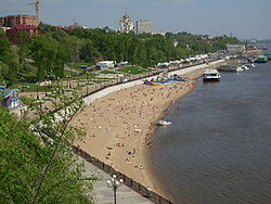
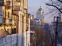
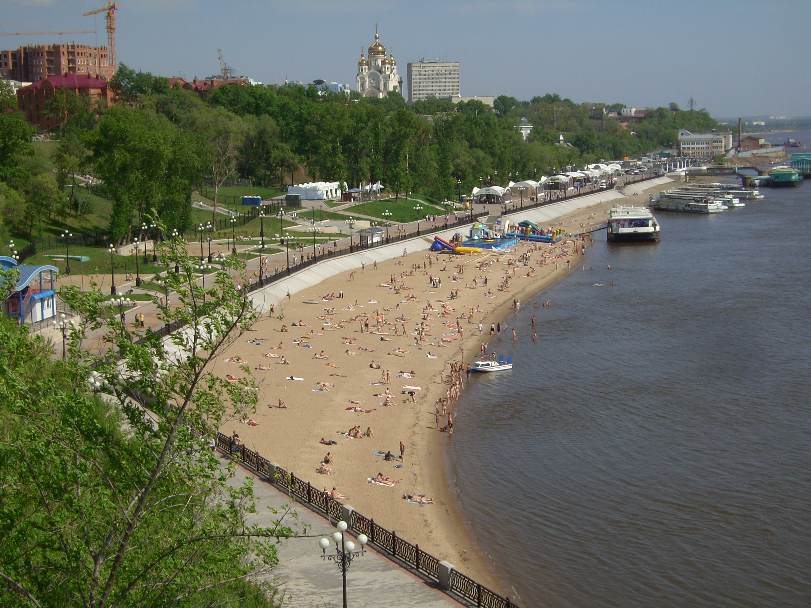
A riverside beach in the city center, with the Saviour Transfiguration Cathedral seen on the background
 Khabarovsk
Coordinates: 48°29′N 135°04′E / 48.483°N 135.067°ECoordinates: 48°29′N 135°04′E / 48.483°N 135.067°E 
Coat of arms City Day Last Sunday of May[citation needed] Administrative status Country Russia Federal subject Khabarovsk Krai Administrative center of Khabarovsk Krai, Khabarovsky District[citation needed] Municipal status Urban okrug Khabarovsk Urban Okrug[citation needed] Mayor[citation needed] Alexander Sokolov[citation needed] Representative body City Duma[citation needed] Statistics Area 372 km2 (144 sq mi)[citation needed] Population (2010 Census,
preliminary)577,700 inhabitants[1] - Rank in 2010 27th Population (2002 Census) 583,072 inhabitants[2] - Rank in 2002 25th Density 1,553 /km2 (4,020 /sq mi)[3] Time zone VLAST (UTC+11:00)[4] Founded May 31, 1858[citation needed] Postal code(s) 680xxx[citation needed] Dialing code(s) +7 4212[citation needed] Official website 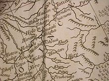 Native villages near the site of the future Khabarovsk according to an English map of 1773. The map is based on an earlier French map by d'Anville, which in its turn makes use of the data collected by Jesuit cartographers in 1709. The village closest to today's Khabarovsk is labeled Hitcha. Maack's "Cape Kyrma" site (thought by B.P. Polyakov to be the site of Stepanov's Kosogorsky Ostrog) is Heremo
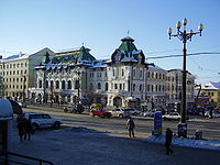 Old City Duma in Khabarovsk
 Russian Orthodox Assumption (Uspensky) Cathedral on Komsomol'skaya Square
Khabarovsk (Russian: Хабаровск, IPA: [xɐˈbarəfsk]) is the largest city and the administrative center of Khabarovsk Krai, Russia. It is located some 30 kilometres (19 mi) from the Chinese border. It is the second largest city in the Russian Far East, after Vladivostok. The city became the administrative center of the Far Eastern Federal District of Russia in 2002. Population: 577,700 (2010 Census preliminary results);[1] 583,072 (2002 Census);[2] 600,623 (1989 Census).[5]
The city lies at the confluence of the Amur and Ussuri Rivers, about 800 kilometres (500 mi) north of Vladivostok and is accessible from there by an overnight train running along the Trans-Siberian railway. Rail distance from Moscow is 8,523 kilometres (5,296 mi).
Contents
History
Earliest history of the region
The lands near the confluence of the Ussuri and the Amur, where today's Khabarovsk stands, have been populated by many centuries by Tungusic people, probably related to the Jurchens of the past and/or the Nanais of the present day. Chinese expeditions reached this area as early as the first half of the 15th century, when the fleets of the Ming eunuch Yishiha sailed several times from Jilin City all the way to Tyr on the lower Amur.
17th century Russian explorers
In the middle of the 17th century the Amur Valley became the scene of hostilities between the Russian Cossacks, trying to expand into the region and to collect tribute from the natives, and the rising Manchu Qing Dynasty, intent on securing the region for itself.
Khabarov's Achansk
The Russian explorers and raiders of the 1650s set up a number of more or less fortified camps (ostrogs) on the Amur; most of them were in use for only a few months, and later destroyed. It is usually thought that the first such camp in the general area of today's Khabarovsk was the fortified winter camp named Achansk (Ачанск, or Ачанский городок), built by the Cossacks of Yerofey Khabarov in September 1651 after they had sailed to the area from the upper Amur. The fort was named after the local tribe whom Khabarov's people called "Achans".[6] [7] Already on October 8 the fort was unsuccessfully attacked by joint forces of Achans and Duchers (who had good reasons to hate the Cossacks, due to their rather heavy-handed tribute-extraction tactics[8]), while many Russians were out fishing.[7] In late November, Khabarov's people undertook a three-day campaign against the local chief Zhakshur (Жакшур) (whose name is also known in a more Russian version, Zaksor (Заксор)), collecting a large amount of tribute and announcing that the locals were now subjects of the Russian Czar. Similar campaign was waged later in winter against the Ducher chief Nechiga (Нечига), farther away from Achansk.[7] On March 24 (or 26) 1652, Fort Achansk was attacked by Manchu cavalry, led by Ninguta's commander Haise, reinforced by Ducher auxiliaries, but the Cossacks stood their ground in a day-long battle and even managed to seize the attackers' supply train.[7] Once the ice on the Amur broke in the spring of 1652, Khabarov's people destroyed their fort and sailed away.[7]
The exact location of Khabarov's Achansk has long been a subject for the debate among Russian historians and geographers.[8][9] A number of locations, both upstream and downstream of today's Khabarovsk, have been proposed since Richard Maack, one of the first Russian scholars to visit the region, identified Achansk in 1859 with the ruins on Cape Kyrma, which is located on the southern (Chinese) shore of the Amur, upstream of Khabarovsk.[8] The most widely accepted point of view is probably that of B.P. Polevoy, who believed that Khabarov's Achansk was located in the Nanai village later known as Odzhal-Bolon (Russian: Оджал-Болонь), located on the left bank of the Amur, closer to Amursk than to Khabarovsk. One of his arguments was that both Khabarov's Achan (sometimes also spelled by the explorer as Otshchan, Отщан), and Wuzhala (乌扎拉) of the Chinese records of the 1652 engagement are based on the name of the Nanai clan "Odzhal" (Оджал), corresponding to the 20th-century name of the village as well. (The name of the clan was also written as "Uzala", as in the name of its best known member, Dersu Uzala).[8]
B.P. Polevoy's view appeared to gain wide support among the Russian georgrapher community; petitioned by the Amur Branch of the Russian Geographical Society, the Russian Government renamed the village of Odzhal to Achan in 1977, to celebrate its connection with Khabarov's raid.[8]
As to the Cape Kyrma ruins, thought by Maack to be the remains of Achansk, B.P. Polevoy identified them as the remains of another ostrog - namely, Kosogorsky Ostrog, where Onufriy Stepanov stayed a few years later.[9]
Stepanov's raids
Another large group of Cossacks, led by Onufriy Stepanov, appeared in the area soon after Khabarov's departure from the Amur, and was active there until its destruction in 1658. Their attempts to penetrate into the Sungari to collect a tribute of grain suffered a setback in 1654, when a joint Manchu-Korean army met the Russian forces at the Battle of Hutong (hangul: 후퉁강 hanja: 厚通江 (混同江)), which was won by Manchu-Korean allied forces.
Four years later, in 1658, Manchu forces commanded by the military governor of Ninguta, Sarhuda and reinforced by the Korean contingent of 260 Korean musketeers and cannoneers sent by King Hyojong and commanded by Shin Ryu, met Onufriy Stepanov's near the mouth of the Sungari River, killing 270 Russians and driving them out of Manchu territory. Those campaigns are better known in Korean chronicles as "Suppression of the Russians" (Nasun Jeongbeol; hangul: 나선정벌 hanja: 羅禪征伐).
Qing Empire
After the Treaty of Nerchinsk (1689), the area became an uncontested part of the Qing Empire for the next century and a half. Modern historical maps of the Qing period published in China mark the site of future Khabarovsk as "Boli". All of the middle and lower Amur region was nominally part of the Jilin Province, run first out of Ninguta and later out of Jilin City.
French Jesuits who sailed along the Ussury and the Amur in 1709, preparing the first more or less precise map of the region. According to them, the indigenous Nanai people living on the Ussury and on the Amur down to the mouth of the Dondon River (i.e., in the region including the site of the future Khabarovsk) were known to the Chinese as Yupi Dazi ("Fishskin Tartars")[10]
From Khabarovka to Khabarovsk
In 1858, the area was ceded to Russia under the Treaty of Aigun. The Russians founded the military outpost of Khabarovka (Хаба́ровка),[11] named after a Russian explorer Yerofey Khabarov. The post later became an important industrial centre for the region. Town status was granted in 1880.
In 1894, a department of Russian Geographical Society was formed in Khabarovsk and began initiating the foundation of libraries, theaters, and museums in the city. Since then, Khabarovsk's cultural life has flourished. Much of the local indigenous history has been well-preserved in the Regional Lore Museum and Natural History Museum and in places like near the Nanai settlement of Sikhachi-Alyan, where cliff drawings from more than 13 000 years ago can be found. The Khabarovsk Art Museum exhibits a rare collection of old Russian icons.
In 1916, Khabarovsk Bridge across the Amur was completed, allowing Transsiberian trains to cross the river without using ferries (or temporary rail tracks over the frozen river in winter). By 1941 a rail tunnel was constructed as well.
After the defeat of Japan in World War II, Khabarovsk was the site of the Khabarovsk War Crime Trials, in which twelve former members of the Japanese Kwantung Army and Unit 731 were put on trial for the manufacture and use of biological weapons during World War II.
Chinese Emperor Puyi, captured by Soviet troops in Manchuria was relocated to Khabarovsk and lived here from 1945 up to 1950, when he was returned to China.[5]
Climate
Khabarovsk experiences a monsoonal dry-winter humid continental climate (Köppen climate classification Dwb).
Climate data for Khabarovsk (1971 - 2000) Month Jan Feb Mar Apr May Jun Jul Aug Sep Oct Nov Dec Year Record high °C (°F) 0.6
(33.1)6.3
(43.3)17.0
(62.6)28.9
(84.0)31.6
(88.9)35.4
(95.7)38.3
(100.9)35.6
(96.1)29.8
(85.6)25.8
(78.4)15.5
(59.9)6.6
(43.9)38.3
(100.9)Average high °C (°F) −16.5
(2.3)−11.3
(11.7)−1.9
(28.6)9.7
(49.5)18.1
(64.6)23.5
(74.3)26.6
(79.9)24.4
(75.9)18.6
(65.5)9.7
(49.5)−3.2
(26.2)−13.8
(7.2)7.0 Average low °C (°F) −24.1
(−11.4)−20.2
(−4.4)−11.4
(11.5)−0.2
(31.6)6.8
(44.2)12.9
(55.2)17.0
(62.6)15.7
(60.3)9.2
(48.6)0.7
(33.3)−10.8
(12.6)−20.8
(−5.4)−2.1 Record low °C (°F) −38.9
(−38.0)−35.1
(−31.2)−28.9
(−20.0)−15.1
(4.8)−3.1
(26.4)2.4
(36.3)7.9
(46.2)4.8
(40.6)−3.3
(26.1)−15.6
(3.9)−27.4
(−17.3)−36.7
(−34.1)−38.9
(−38.0)Precipitation mm (inches) 15
(0.59)11
(0.43)17
(0.67)43
(1.69)58
(2.28)82
(3.23)144
(5.67)154
(6.06)89
(3.5)51
(2.01)23
(0.91)18
(0.71)705
(27.76)% humidity 73 71 65 60 60 71 77 79 74 63 65 72 69.2 Avg. precipitation days 3.3 3.2 4.2 7.0 8.8 9.1 10.3 11.0 9.5 6.5 5.1 4.6 82.6 Sunshine hours 145.7 182.0 232.5 213.0 234.0 261.0 248.0 217.0 213.0 189.1 159.0 145.7 2,440 Source no. 1: Pogoda.ru.net[12] Source no. 2: HKO Transportation
Khabarovsk is served by Khabarovsk Novy Airport with international flights to East Asia, Southeast Asia, European Russia, and Central Asia. It is also served by the Trans-Siberian Railway, the Trans-Siberian Highway (M58 and M60 Highways) and the Amur River and Ussuri River waterways.
Education
There are the following institutions of higher education in Khabarovsk.[13][14]
- Pacific National University (former Khabarovsk State University of Technology)
- Far Eastern State University of Humanities (former Khabarovsk State Teachers Training University)
- Far Eastern State Medical University
- Khabarovsk State Academy of Economics and Law
- Far Eastern State Transport University
- Far Eastern Academy of Government Services
- Far Eastern State Physical Education University
- Khabarovsk State Institute of Arts and Culture
Tourism
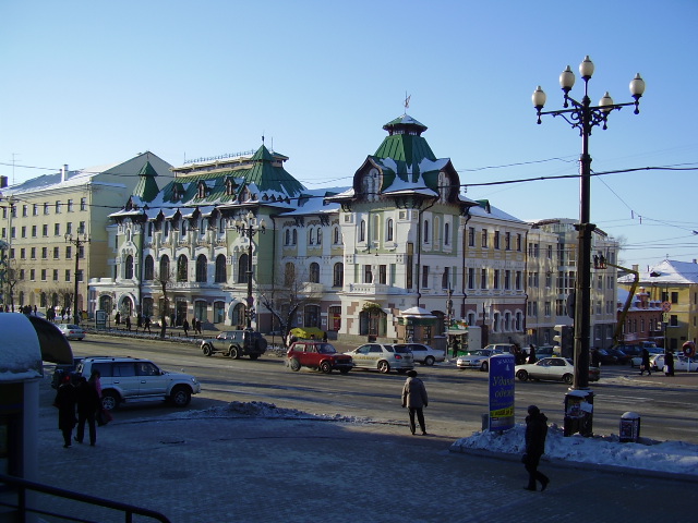
 A view along Turgenev Street toward the Savior Transfiguration (Spaso-Preobrazhenskiy) Cathedral
Visitors to the picturesque city of Khabarovsk are likely to enjoy walking the broad Amursky Boulevard with its many vibrant shops and perhaps visit the local market. The city's five districts stretch for 45 kilometres (28 mi) along the Amur River.
Recently, there have been many renovations in the city's central part, rebuilding with historical perspective. A popular attraction for visitors is a walking tour from the Lenin Square to Utyos on Amur via Muravyov-Amursky Street, where visitors can find traditional Russian cuisine restaurants and shops with souvenirs. There are many night clubs and pubs in this area. In Wintertime ice sculptures are on display on the cities squares and parks. Artists come from as far as Harbin in China.
Unlike Vladivostok, the city has never been closed to foreigners, despite it being the headquarters of the Far East Military District, and retains its historically international flavour. Once the capital of the Soviet Far East (from 1926 to 1938), since the demise of the Soviet Union it has experienced an increased Asian presence. It is estimated that over one million Chinese travel to and through Khabarovsk yearly, and foreign investment by Japanese and Korean corporations has grown in recent years. The city has a multi-storey shopping mall and about a dozen hotels.
To introduce oneself to the culture of local aborigines, Nanai people, as well as to learn more about neolithic origines of tribes there is a notable destination Sikhachi-Alyan.
Sports
- Khabarovsk is home to a Kontinental Hockey League franchise, Amur Khabarovsk, which plays its home games at the Platinum Arena. It is the easternmost-based team in the league.
- FC SKA-Energiya Khabarovsk is the city's best football team, playing in the Russian First Division which is the second tier of Russian football since 2002 season.
- SKA Neftyanik[15] plays in the highest division of the Russian Bandy League.
In 1981 the city hosted the Bandy World Championships. An indoor arena for bandy will be built as one of the first in Russia.[6]
Notable residents
- Birthplace of NHL and Russian hockey great Alexander Mogilny
- Birthplace of 2005 Miss Russia winner Alexandra Ivanovskaya
- Birthplace of Russian filmmaker Sergei Bodrov
- Birthplace of professional cycler Andrei Tchmil
- Birthplace of speed skater Ivan Skobrev
- Birthplace of mathematician Efim Zelmanov
- Birthplace of Olympic champion, figure skater Evgeni Plushenko
- Residence of two time European Champion, World Champion, Olympic silver medalist in shooting Aleksandr Blinov.
International relations
Twin towns — sister cities
Khabarovsk is twinned with the following sister cities:[16]

 Bucheon, South Korea
 Niigata, Niigata, Japan
 Harbin, Heilongjiang, China
 Villeurbanne, Rhône, France
 Anchorage, Alaska, United States
-
 Portland, Oregon, United States
 Victoria, British Columbia, Canada
- Mudanjiang, Heilongjiang, China
Trivia
- Khabarovsk placed first in different categories of "Most Developed and Comfortable City of Russia" in 2006,[17] 2008[18] and 2009.
- In 2010 Khabarovsk got second place in Forbes list of most suitable cities for private business in Russia,[19] first place went to Krasnodar.
References
- ^ a b Федеральная служба государственной статистики (Federal State Statistics Service) (2011). "Предварительные итоги Всероссийской переписи населения 2010 года (Preliminary results of the 2010 All-Russian Population Census)" (in Russian). Всероссийская перепись населения 2010 года (All-Russia Population Census of 2010). Federal State Statistics Service. http://www.perepis-2010.ru/results_of_the_census/results-inform.php. Retrieved 2011-04-25.
- ^ a b Федеральная служба государственной статистики (Federal State Statistics Service) (2004-05-21). "Численность населения России, субъектов Российской Федерации в составе федеральных округов, районов, городских поселений, сельских населённых пунктов – районных центров и сельских населённых пунктов с населением 3 тысячи и более человек (Population of Russia, its federal districts, federal subjects, districts, urban localities, rural localities—administrative centers, and rural localities with population of over 3,000)" (in Russian). Всероссийская перепись населения 2002 года (All-Russia Population Census of 2002). Federal State Statistics Service. http://www.perepis2002.ru/ct/doc/1_TOM_01_04.xls. Retrieved 2010-03-23.
- ^ The value of density was calculated automatically by dividing the 2010 Census population by the area specified in the infobox. Please note that this value may not be accurate as the area specified in the infobox does not necessarily correspond to the area of the entity proper or is reported for the same year as the population.
- ^ Правительство Российской Федерации. Постановление №725 от 31 августа 2011 г. «О составе территорий, образующих каждую часовую зону, и порядке исчисления времени в часовых зонах, а также о признании утратившими силу отдельных Постановлений Правительства Российской Федерации». Вступил в силу по истечении 7 дней после дня официального опубликования. Опубликован: "Российская Газета", №197, 6 сентября 2011 г. (Government of the Russian Federation. Resolution #725 of August 31, 2011 On the Composition of the Territories Included into Each Time Zone and on the Procedures of Timekeeping in the Time Zones, as Well as on Abrogation of Several Resolutions of the Government of the Russian Federation. Effective as of after 7 days following the day of the official publication).
- ^ "Всесоюзная перепись населения 1989 г. Численность наличного населения союзных и автономных республик, автономных областей и округов, краёв, областей, районов, городских поселений и сёл-райцентров. (All Union Population Census of 1989. Present population of union and autonomous republics, autonomous oblasts and okrugs, krais, oblasts, districts, urban settlements, and villages serving as district administrative centers.)" (in Russian). Всесоюзная перепись населения 1989 года (All-Union Population Census of 1989). Demoscope Weekly (website of the Institute of Demographics of the State University—Higher School of Economics. 1989. http://demoscope.ru/weekly/ssp/rus89_reg.php. Retrieved 2010-03-23.
- ^ АРХЕОЛОГИ ОБНАРУЖИЛИ НА АМУРЕ ТАИНСТВЕННЫЙ ГОРОДОК. Возможно, это первое русское поселение в данном регионе (Mysterious fort found by archaeologists on the Amur. Possibly, this is the first Russian settlement in this region) (Russian)
- ^ a b c d e Оксана ГАЙНУТДИНОВА (Oksana Gainutdinova) Загадка Ачанского городка (The mystery of Fort Achansk)
- ^ a b c d e B.P. Polevoy (Б.П. Полевой), Изветная челобитная С. В. Полякова 1653 г. и ее значение для археологов Приамурья (S.V. Polyakov's denouncing letter (1653), and its significance for the archaelogists of the Amur Valley), in: Русские первопроходцы на Дальнем Востоке в XVII-XIX вв. (Историко-археологические исследования) (First Russian explorers in the Far East in the 17th-19th centuries: Historical and archaeological research - B.P.Polevoy's preface to the document), vol. 2, Vladisvostok, Russian Academy of Sciences, 1995. (This article also contains references to Polevoy's earlier publications) (Russian)
- ^ a b Б.П. Полевой (B.P. Polevoy) О ПОДЛИННОМ МЕСТОПОЛОЖЕНИИ КОСОГОРСКОГО ОСТРОГА 50-Х гг. XVII ВЕКА (About the true location of the Kosogorsky Ostrog of the 1650s) (Russian)
- ^ Du Halde, Jean-Baptiste (1735). Description géographique, historique, chronologique, politique et physique de l'empire de la Chine et de la Tartarie chinoise. Volume IV. Paris: P.G. Lemercier. p. 7. http://web2.bium.univ-paris5.fr/livanc/?cote=00992x04&do=chapitre. Numerous later editions are available as well, including one on Google Books
- ^ [1]
- ^ "Pogoda.ru.net" (in Russian). http://pogoda.ru.net/climate/31735.htm. Retrieved May 26, 2009.
- ^ The Institutions of Higher Education in Khabarovsk Krai
- ^ The Universities in Khabarovsk
- ^ http://dvbandy.narod.ru/ska.html
- ^ Khabarovsk city administration
- ^ [2]
- ^ [3]
- ^ [4]
- A.M. Bodisko. From life of Khabarovsk. Khabarovsk, 1913.
- Nikolay P. Kradin. It is protected by the state: The Monuments of Architecture in Khabarovsk. Khabarovsk: Chastnaya kollektsiya, 1999. 192 p. ISBN 5-7875-0011-3
External links
- Khabarovsk city Administration
- Khabarovsk travel guide from Wikitravel
- (Korean) Manchu-Korean expedition against Russian expansion (나선정벌 (羅禪征伐)
- (Korean) map of the Manchu-Korean expedition against Russian expansion (나선정벌 (羅禪征伐)
- (Russian) Major problems of Russian-Korean relationship
- (Russian) CHINA AND RUSSIA relationship and history
Administrative center: Khabarovsk 
Cities and towns 
Administrative districts Amursky · Ayano-Maysky · Bikinsky · Khabarovsky · Komsomolsky · imeni Lazo · Nanaysky · Nikolayevsky · Okhotsky · imeni Poliny Osipenko · Solnechny · Sovetsko-Gavansky · Tuguro-Chumikansky · Ulchsky · Vaninsky · Verkhnebureinsky · VyazemskyRussian Far East Topics Federal subjects Largest cities Vladivostok · Khabarovsk · Komsomolsk-on-Amur · Blagoveshchensk · Yakutsk · Petropavlovsk-Kamchatsky · Yuzhno-Sakhalinsk · Nakhodka · Ussuriysk · Magadan · BirobidzhanCategories:- Khabarovsk
- Geography of Northeast Asia
- Russian Far East


Wikimedia Foundation. 2010.