- Jilin
-
For the city, see Jilin City.
Coordinates: 43°42′N 126°12′E / 43.7°N 126.2°E
Jilin Province Chinese : 吉林省 Jílín Shěng Abbreviations: 吉 (pinyin: Jí) 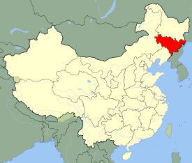
Origin of name from girin ula, a Manchu phrase meaning "along the river" Administration type Province Capital
(and largest city)Changchun CPC Ctte Secretary Sun Zhengcai Governor Wang Rulin Area 187,400 km2 (72,400 sq mi) (13th) - Latitude 40° 52' to 46° 18' N - Longitude 121° 38' to 131° 19' E Population (2010)
- Density27,462,297 (21st)
145 /km2 (380 /sq mi) (23rd)GDP (2010)
- per capitaCNY 857.7 billion (US$126.7 billion) (22st)
CNY 26,289 (11th)HDI (2008) 0.815 (high) (9th) Ethnic composition Han - 91%
Korean - 4%
Manchu - 4%
Mongol - 0.6%
Hui - 0.5%Spoken dialects {{{Dialects}}} Prefectural level 9 divisions County level 60 divisions Township level* 1006 divisions ISO 3166-2 CN-22 Official website
http://www.jl.gov.cn
(Simplified Chinese)Source for population and GDP data: 《中国统计年鉴—2005》 China Statistical Yearbook 2005Source for nationalities data:
ISBN 7503747382《2000年人口普查中国民族人口资料》 Tabulation on nationalities of 2000 population census of China*As at December 31, 2004
ISBN 7105054255Template ■ Discussion ■ WikiProject China Jilin (Chinese: 吉林; pinyin: Jílín; Wade–Giles: Chi-lin, IPA: [tɕǐlǐn] (
 listen); Postal map spelling: Kirin), is a province of the People's Republic of China located in the northeastern part of the country. Jilin borders North Korea and Russia to the east, Heilongjiang to the north, Liaoning to the south, and Inner Mongolia to the west. The name was transliterated to Kirin before standardization to pinyin.
The name "Jilin" probably originates from Girin ula ᡤᡳ᠍ᡵᡳ᠌ᠨ ᡠᠯᠠ, a Manchu term meaning "along the river"; this was transcribed into Jilin wula (T: 吉林烏拉 / S: 吉林乌拉) in Chinese, then shortened to Jilin.[1] The literal meaning of the Chinese characters for "Jilin" is "auspicious forest".
Contents
History
Main article: History of JilinIn ancient times Jilin was inhabited by various peoples, notably the Xianbei, Koreans, the Mohe and the Wùjí (勿吉).[2] Various Korean kingdoms, including the Buyeo, Goguryeo and Balhae, were established in this area.
The region then fell successively under the domination of the Khitan Liao Dynasty, the Jurchen Jin Dynasty, and the Mongol Yuan Dynasty. During the Qing Dynasty, much of the area was under the control of the General of Jilin, whose area of control extended to the Sea of Japan to encompass much of what is Russia's Primorsky Krai today. Immigration of Han Chinese was strictly controlled.
But, after the Primorsky Krai area was ceded to Russia in 1860, the Qing government began to open the area up to Han Chinese migrants, most of whom came from Shandong. By the beginning of the twentieth century, Han Chinese had become the dominant ethnic group of the region. In 1932, the area was incorporated into Manchukuo, a puppet state set up by Japan. Changchun (then called Hsinking), capital of Jilin today, was made the capital of Manchukuo. After the defeat of Japan in 1945, the region, together with the rest of northeastern China, was ceded to the Communists by the Soviet Union. Manchuria was the staging ground from which the communists eventually conquered the rest of China (see Chinese Civil War#Post-war power struggle (1945–1947)).
In 1949, Jilin province was smaller, encompassing only the environs of Changchun and Jilin City, and the capital was at Jilin City, while Changchun was a municipality independent from the province. In the 1950s, Jilin was expanded to its present borders. During the Cultural Revolution, Jilin was expanded again to include a part of Inner Mongolia, giving it a border with the independent state of Mongolia, though this was later reversed. In recent times Jilin has, together with the rest of heavy industry-based Northeast China, been facing economic difficulties with privatization. This has prompted the central government to undertake a campaign called “Revitalize the Northeast”.
Geography
Jilin lies in the central part of northeastern China, bordering Russia and North Korea in the east and southeast respectively. Jilin has a total area of 190,000 square kilometers and a total population of 27.3 million. Its capital is Changchun, which lies 113 kilometers west of Jilin city.[3] Jilin province is rich in natural mineral deposits with 136 different types of minerals, of which 70 have already been extracted. Jilin has abundance of Traditional Chinese medicine resources, with approximately 27,000 kinds of wild plants and 9,000 kinds of medicinal herbs.[4] Also the province is rich in large reserves of oil, gas, coal, iron mine, nickel, molybdenum, talc, graphite, gypsum, cement rock, gold and silver; its reserves of oil shale are the largest in the country.[5]
Jilin is highest in altitude in the southeast, and drops gently towards the northwest. The Changbai Mountains run through its southeastern regions, and contains the highest peak of the province, Baiyun Peak at 2691 m. Other mountain ranges include the Jilinhada Mountains, Zhang Guangcai Mountains, and Longgang Mountains.
Jilin is drained by the Yalu and Tumen Rivers in the extreme southwest (which together form the border between the People's Republic of China and North Korea), by tributaries of the Liao River along the southern border, and by the Songhua and Nen rivers, both eventually flowing into the Amur.
Jilin has a northerly continental monsoon climate, with long, cold winters and short, warm summers. Average January temperatures range from -20 to -14°C. Rainfall averages at 350 to 1000 mm.
Major cities in this province include Changchun, Jilin City, Baishan, Baicheng, Siping, Yanji, Songyuan, Tonghua and Liaoyuan[5]
Administrative divisions
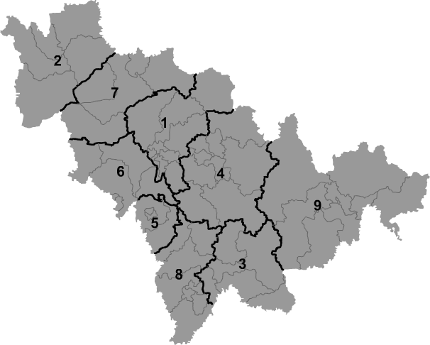
Jilin consists of eight prefecture-level cities and one autonomous prefecture:
Map # Name Hanzi Hanyu Pinyin Administrative Seat 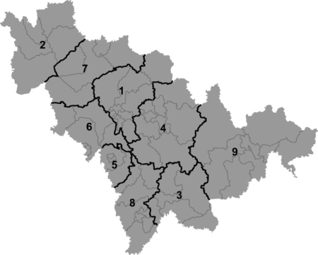
— Sub-provincial city — 1 Changchun 长春市 Chángchūn Shì Chaoyang District — Prefecture-level city — 2 Baicheng 白城市 Báichéng Shì Taobei District 3 Baishan 白山市 Báishān Shì Badaojiang District 4 Jilin 吉林市 Jílín Shì Chuanying District 5 Liaoyuan 辽源市 Liáoyuán Shì Longshan District 6 Siping 四平市 Sìpíng Shì Tiexi District 7 Songyuan 松原市 Sōngyuán Shì Ningjiang District 8 Tonghua 通化市 Tōnghuà Shì Dongchang District — Autonomous Prefecture — 9 Yanbian (Korean) 延边朝鲜族自治州 Yánbiān Cháoxiǎnzú Zìzhìzhōu Yanji For a complete list of the county-level divisions of Jilin, see List of administrative divisions of Jilin. These administrative divisions are explained in greater detail at Administrative divisions of the People's Republic of China.
Politics
Main article: Politics of JilinThe politics of Jilin is structured in a dual party-government system like all other governing institutions in mainland China.
The Governor of Jilin is the highest ranking official in the People's Government of Jilin. However, in the province's dual party-government governing system, the Governor has less power than the Jilin Communist Party of China Provincial Committee Secretary, colloquially termed the "Jilin CPC Party Chief".
Economy
Main article: Economy of JilinIn 2009, the nominal GDP of Jilin province totaled RMB 720.3 billion (US$105.5 billion). Its GDP has been rising at double-digit rate since 2003 growing 51 percent from 2003 to 2007. Per capita nominal GDP increased to RMB 26,289 (US$3,848) in 2009. Meanwhile, the incremental value and profit of large enterprises witnessed a sharp increase of 19 percent and 30 percent respectively, compared with 2005 figures.[5]
Jilin's agricultural production is centered upon rice, maize, and sorghum. Rice is mostly cultivated in the eastern parts, such as Yanbian Prefecture. The Changbai Mountains are an important source of lumber. Herding of sheep is an important activity in the western parts, such as Baicheng.
Among it's natural resources, Jilin has the largest reserves of shale oil and one of the top five largest mineral reserves in all of China[6] Compared to other provinces of China, Jilin has extensive deposits of Kieselguhr, wollastonite, floatstone, and molybdenum.
Industry in Jilin is concentrated on automobiles, train carriages, and iron alloy.
Jilin is one of the most important commodity grain bases in China[3] Ranked 6th in timber production[5] Traditionally, Jilin has been known as a major pharmaceutical center, with yields of ginseng and deer antlers among the largest in China, being used extensively in Traditional Chinese medicine [4][7]
Economic and Technological Development Zones
- Jilin New and Hi-tech Industry Development Zone
The zone was founded in 1992 and is located in Jilin city covering 818 square kilometers of planned area with 242 square kilometers already established. The leading industries in the zone are new materials, refined chemical products, integration of photoelectron and mechanism, electronics, medicine and bioengineering.[3] A mere 14 km away from Songhua Lake, the nearest bus and train stations are located within 3 km.[8]
The Jilin Economic and Technological Development Zone was founded in May 1998 and is situated in the northeast of Jilin city. The zone has a total planned area of 28 square kilometers. It is located 90 kilometers from Changchun, five kilometers from Jilin Airport, and eight kilometers from Jilin Railway Station. Major industries include refined chemicals, bioengineering, fine processing of chemical fiber, and farm products. It is divided into four parts, namely, the Chemical Industrial Park, the Food Industrial Park, the Textile Industrial Park and the Medical Industrial Park. The latter specializes in the development of traditional Chinese pharmaceuticals, mini molecule medicine, bio-pharmaceuticals and health products.[3]
Other zones include:
- State-level ETDZs Changchun Economic and Technological Development Zone
In 1993, with the approval of the state, Changchun Economic & Technological Development Zone (CETDZ) became a state level economic and technological development zone. The total area of CETDZ is 112.72 sqkm, of which 30 sqkm has been set aside for development and utilization. By the end of 2006, the total fixed assets investment of Changchun economic and technological development zone reached 38.4 billion Yuan. There are 1656 registered enterprises in this zone including 179 foreign-funded enterprises. The regional gross product of the zone reached 101.8 billion Yuan; industrial output value reached 233.0 billion Yuan; overall financial revenue reached 15.7 billion Yuan.[9]
- State-level HIDZs Changchun High-Tech Industrial Development Area
Changchun High-Tech Industrial Development Area is connected by four roads and one light-rail to the downtown area. The nearest train station, Changchun Station, is twenty minutes away by light rail. In 2002, Changchun HDA became the first park in North-East China to qualify for the environmental certification of ISO14001. Its landscaping ratio reaches 38%.[10]
- Hunchun Border Economic Cooperation Zone
Huichun Border Economic Cooperation Zone was approved to be national-level border economic cooperation zone in 1992, with a planning area of 24 sqkm. In 2002 and 2001, Huichun Export Processing Zone and Huichun Sino-Russia Trade Zone was set up in it. Being located in the junction of China, Russia and Korea, it enjoys strategic location. The infrastructures are available. It focuses on the development of sea food processing, electronic product manufacture, bio-pharmacy, textile industry and other industry.[11]
- Hunchun Export Processing Zone
Huichun Export Processing Zone is located in 5 sqkm area in Hun Chun Border Economic Cooperation Zone. Its planned area is 2.44 sqkm. It enjoys the good infrastructure and policies its parent zone does.[12]
Infrastructure
There are 35,216 kilometers of highways, including over 500 kilometers of expressways. The province has an excellent rail network, originally built by the Japanese, with Changchun as its main hub. There are four major new railway projects which started construction in 2007. They will include the middle section of a massively invested north-south railway trunk line connecting Harbin and Dalian, and a 96.5 kilometer inter-city railway line from Changchun, capital city of Jilin province, and Jilin city. The four railway projects are estimated to cost RMB13 billion and the province is urging foreign investors to invest in the new project. The Changchun-Jilin line, expected to be completed in 2010, will cut the journey times between the cities from the current 96 minutes to 30.[3]
The only commercial airport is Changchun International Airport, other non-commercial airports are Jilin Airport, Yanji Airport and Tonghua Liuhe Airport. [4]
Jilin is landlocked. However, river navigation is possible from April to November. The major river ports are at Da'an, Jilin city and Fuyu. In 2007, Jilin started construction on a two-phase RMB60 million comprehensive river port; the first phase of this is finished. The port is located on the Songhua River and has an annual throughput of two million tons and will connect to the waterways of Northeast China.[5]
Demographics
Jilin is inhabited by Han Chinese, Manchus, Hui, Mongols and Xibe. Most ethnic Koreans live in the Yanbian Korean Autonomous Prefecture.
Ethnic groups in Jilin (2000 census) Nationality Population Percentage Han Chinese 24,348,815 90.85% Koreans 1,145,688 4.27% Manchu 993,112 3.71% Mongol 172,026 0.64% Hui 125,620 0.47% Excludes members of the People's Liberation Army in active service.
Source: Department of Population, Social, Science and Technology Statistics of the National Bureau of Statistics of China (国家统计局人口和社会科技统计司) and Department of Economic Development of the State Ethnic Affairs Commission of China (国家民族事务委员会经济发展司), eds. Tabulation on Nationalities of 2000 Population Census of China (《2000年人口普查中国民族人口资料》). 2 vols. Beijing: Nationalities Publishing House (民族出版社), 2003. (ISBN 7-105-05425-5)Culture
Jilin is part of Northeast China, so shares many similarities in culture to neighbouring regions, such as Er ren zhuan, Stilts and Yangge. But among its music, Jiju, or Jilin Opera, is a form of traditional entertainment that Jilin has innovated over its short migrant history.
The ethnic Koreans of Jilin have their own distinct culture. See also: Yanbian Korean Autonomous Prefecture, Culture of Korea.
Tourism
The Goguryeo sites and tombs found in Ji'an, Jilin, including Wandu, Gungnae Fortress, and the pyramidal General's Tomb, have been listed as part of a UNESCO World Heritage Site.
The Baekdu Mountain, especially Heaven Lake on the border with North Korea, are popular tourist destinations due to their natural scenery.
Ancient Tombs at Longtou Mountain, including the Mausoleum of Princess Zhenxiao, are royal tombs of the Balhae kingdom found in Yanbian Korean Autonomous Prefecture.
Education
Universities and colleges
See also: List of universities and colleges in Jilin- Jilin University (吉林大学)
- Northeast Normal University (东北师范大学)
- Jilin Agricultural University (吉林农业大学)
- Jilin Normal University (吉林师范大学)
- Changchun University of Science and Technology (长春理工大学)
- Changchun University of Technology (长春工业大学)
- Changchun Normal University (长春师范大学)
- Changchun University[disambiguation needed
 ] (长春大学)
 - Changchun Taxation College (长春税务学院)
- Yanbian University of Science and Technology (延边科技大学)
- Yanbian University (延边大学)
- Northeast China Institute of Electric Power Engineering (东北电力学院)
- Jilin College of Electrification
- Changchun Institute of Post & Telecommunications (长春邮政学院)
- Changchun Institute of Optics and Fine Mechanics
Sports
Professional Sports Teams
Notes
- ^ (Chinese) Origin of the Names of China's Provinces, People's Daily Online.
- ^ 前言
- ^ a b c d e "Dezan Shira & Associates". Dezan Shira & Associates. 2009. http://www.dezshira.com. Retrieved 2009-02-08.
- ^ a b c "China Expat city Guide Jilin". China Expat. 2008. http://www.chinaexpat.com/city/jilin-city. Retrieved 2009-02-08.
- ^ a b c d e "China Briefing Business Reports". Asia Briefing. 2007. http://shopping.china-briefing.com/index_eproduct_view.php?products_id=21. Retrieved 2009-02-12.[dead link]
- ^ http://thechinaperspective.com/topics/province/jilin-province/
- ^ http://thechinaperspective.com/topics/province/jilin-province/
- ^ RightSite.asia | Jilin Hi-Tech Development Zone
- ^ RightSite.asia | Changchun Economic and Technology Development Zone
- ^ RightSite.asia | Changchun High-Tech Industrial Development Area
- ^ RightSite.asia | Huichun Border Economic Cooperation Zone
- ^ RightSite.asia | Huichun Export Processing Zone
External links
- Jilin Government website
- Jilin Administration of Industry and Commerce
- Development zones and ports
- Jilin travel guide from Wikitravel

Heilongjiang  Russia
Inner Mongolia 
 Jilin
Jilin 

Liaoning  Rasŏn, North Hamgyong, Ryanggang, and Chagang, North Korea
Jilin topics General Geography Education Culture Visitor attractions Gungnae Fortress • Tomb of the General • Baekdu Mountain • Heaven Lake • Ancient Tombs at Longtou Mountain • Mausoleum of Princess ZhenxiaoJilin Province county-level divisions Changchun: Chaoyang District · Kuancheng District · Erdao District · Nanguan District · Luyuan District · Shuangyang District · Jiutai City · Yushu City · Dehui City · Nong'an County Jilin in China
Jilin City: Chuanying District · Changyi District · Longtan District · Fengman District · Shulan City · Huadian City · Jiaohe City · Panshi City · Yongji County
Siping: Tiexi District · Tiedong District · Gongzhuling City · Shuangliao City · Lishu County · Yitong Manchu Autonomous County
Liaoyuan: Longshan District · Xi'an District · Dongliao County · Dongfeng County
Tonghua: Dongchang District · Erdaojiang District · Meihekou City · Ji'an City · Tonghua County · Huinan County · Liuhe County
Baishan: Hunjiang District · Jiangyuan District · Linjiang City · Jingyu County · Fusong County · Changbai County
Songyuan: Ningjiang District · Qian'an County · Changling County · Fuyu County · Qian Gorlos County (Mongol Autonomous)
Baicheng: Taobei District · Da'an City · Taonan City · Zhenlai County · Tongyu County
Yanbian: Yanji City · Tumen City · Dunhua City · Longjing City · Hunchun City · Helong City · Antu County · Wangqing CountyProvincial level divisions of the People's Republic of China Provinces 
Autonomous regions Municipalities Special Administrative Regions Territorial disputes - Paracel, Spratly, Zhongsha Islands (see Paracels, Spratlys, & Zhongsha Iss. Authority)
- Pratas Islands
- Senkaku Islands
- South Tibet
- Taiwan, Kinmen & Matsu (see Legal status of Taiwan)
Categories:


Wikimedia Foundation. 2010.