- Senkaku Islands
-
"Diaoyutai" redirects here. For the Chinese state guesthouse, see Diaoyutai State Guesthouse.
Senkaku Islands Disputed islands
Other names: Japanese: 尖閣諸島
Chinese: 釣魚台列嶼 or 钓鱼岛及其附属岛屿
Pinnacle Islands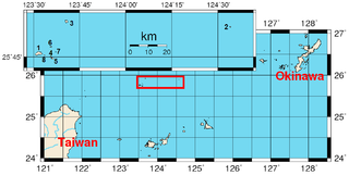
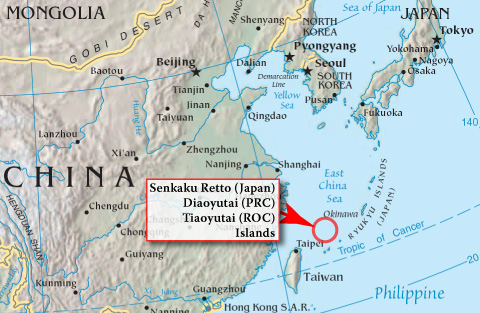
Location of the islands (inside red rectangle and inset). Geography 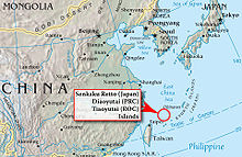
Location Pacific Ocean Coordinates 25°47′53″N 124°03′21″E / 25.79806°N 124.05583°E Total islands 5 + 3 rocks Major islands Uotsuri Jima / Diaoyu Dao
Taisho Jima / Chiwei Yu
Kuba Jima / Huangwei Yu
Kita Kojima / Bei Xiaodao
Minami Kojima / Nan XiaodaoArea 7 square kilometres (1,700 acres) Administered by  Japan
JapanCity Ishigaki, Okinawa Claimed by JapanCity Ishigaki, Okinawa  People's Republic of China
Township Toucheng, Yilan County, Taiwan Province  Republic of China (Taiwan)
Township Toucheng, Yilan County, Taiwan Province The Senkaku Islands (尖閣諸島 Senkaku Shotō, variants: Senkaku-guntō[1] and Senkaku-rettō[2]), also known as the Diaoyu Islands or Diaoyutai Islands (simplified Chinese: 钓鱼岛及其附属岛屿; traditional Chinese: 釣魚台群島; pinyin: Diàoyútái Qúndǎo) or the Pinnacle Islands, are a group of disputed uninhabited islands in the East China Sea. They are located roughly due east of mainland China, northeast of Taiwan, west of Okinawa Island, and north of the southwestern end of the Ryukyu Islands.
Japan controlled these islands from 1895 until her surrender at the end of World War II. The United States administered them as part of the United States Civil Administration of the Ryukyu Islands from 1945 until 1972, when the islands reverted to Japanese control under the Okinawa Reversion Treaty between the United States and Japan. Since 1971, they have been actively claimed by both the People's Republic of China and the Republic of China (Taiwan). The Chinese claim the discovery and control of the islands from the 14th century.[3]
The islands are a major issue in foreign relations between Japan and the PRC and between Japan and the ROC.[4] Despite the complexity of relations between the PRC and ROC, both governments agree that the islands are part of Taiwan as part of Toucheng Township in Yilan County of their respective divisions. The Japanese government regards these islands as a part of Ishigaki, Okinawa Prefecture.
Contents
Early historical context
Records of these islands date back to as early as the 15th century. They were referred as Diaoyu in books such as Voyage with a Tail Wind (simplified Chinese: 顺风相送; traditional Chinese: 順風相送; pinyin: Shǜnfēng Xiāngsòng) (1403) [5] and Record of the Imperial Envoy's Visit to Ryūkyū (simplified Chinese: 使琉球录; traditional Chinese: 使琉球錄; pinyin: Shĭ Liúqiú Lù) (1534). Adopted by the Chinese Imperial Map of the Ming Dynasty, both the Chinese name for the island group (Diaoyu) and the Japanese name for the main island (Uotsuri) both literally mean "angling".[citation needed]
The first published description of the islands in Europe was in a book imported by Isaac Titsingh in 1796. His small library of Japanese books included Sangoku Tsūran Zusetsu (三国通覧図説 An Illustrated Description of Three Countries) by Hayashi Shihei.[6] This text, which was published in Japan in 1785, described the Ryūkyū Kingdom.[7] In 1832, the Oriental Translation Fund of Great Britain and Ireland supported the posthumous abridged publication of Titsingh's French translation.[8]
The first reference to the islands in a book published in English was Edward Belcher's 1848 account of the voyages of HMS Sammarang.[9] Captain Belcher observed that "the names assigned in this region have been too hastily admitted."[10] Belcher reported anchoring off Pinnacle Island in March 1845.[11]
In 1870s and 1880s, the English name Pinnacle Islands was used by the British navy for the rocks adjacent to the largest island Uotsuri Jima/Diaoyu Dao (then called Hoa-pin-su); Kuba Jima/Huangwei Yu (then called Ti-a-usu); and Taishō Jima/Chiwei Yu.[12] The name "Pinnacle Islands" is used by some as an English-language equivalent to "Senkaku" or "Diaoyu".[13]
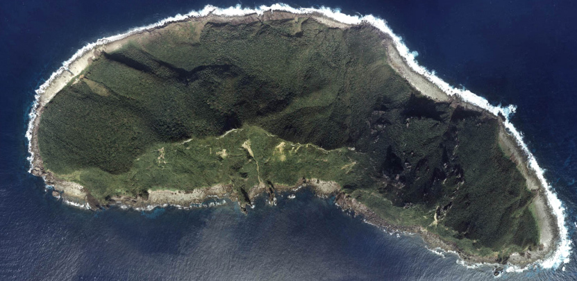
 One islet of the group–Uotsuri Jima
In 1900, when Tsune Kuroiwa, a teacher at the Okinawa Prefecture Normal School, visited the islands, he adopted the name Senkaku Retto (simplified Chinese: 尖阁列岛; traditional Chinese: 尖閣列島; pinyin: Jiāngéliè Dăo), literally Pinnacle Islands, to refer the whole island group, based on the British name. The first official document recording the name Senkaku Retto was by the Japanese Ministry of Foreign Affairs in Nihon Gaiko Monjo (日本外交文書, Documents on Japanese Foreign Relations) in the 1950s.[citation needed] In Japanese, Sentō Shosho (尖頭諸嶼) and Senkaku Shosho (尖閣諸嶼) were translations used for these "Pinnacle Islands" by various Japanese sources. Subsequently, the entire island group came to be called Senkaku Rettō, which later evolved into Senkaku Shotō.[citation needed]
The collective use of the name "Senkaku" to denote the entire group began with the advent of the controversy in the 1970s.[14]
History under Japanese and US control
 Japanese workers at a bonito fisheries processing plant on Uotsurishima sometime around 1910[15]
The Japanese central government formerly annexed the islands on January 14, 1895. Around 1900, Japanese entrepreneur Koga Tatsushiro constructed a bonito processing plant on the islands with 200 workers. The business failed in 1940 and the islands have remained deserted ever since. The plots of land on the islands still technically belong as private property to Koga's descendants.[15]
The islands were under US government occupation authority from 1945 until 1972.[15] Since the islands reverted to Japanese government control in 1972, the mayor of Ishigaki has been given civic authority over the territory. The Japanese central government, however, has prohibited Ishigaki from surveying or developing the islands.[15] On December 17, 2010, Ishigaki declared January 14 as "Pioneering Day". China condemned Ishigaki's actions.[16]
Geography
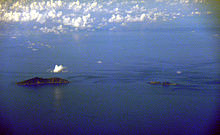 A cluster of islets–Uotsuri Jima (left), Kita Kojima and Minami Kojima (right)
The island group consists of five uninhabited islets and three barren rocks.
These minor features in the East China Sea are located approximately 120 nautical miles northeast of Taiwan, 200 nautical miles east of the Chinese mainland and 200 nautical miles southwest of the Japanese island of Okinawa.[17]
In ascending order of distances, the island cluster is located:
- 140 kilometres (76 nmi; 87 mi) east of Pengjia Islet, ROC [18]
- 170 kilometres (92 nmi; 110 mi) north of Ishigaki Island, Japan
- 186 kilometres (100 nmi; 116 mi) northeast of Keelung, ROC
- 410 kilometres (220 nmi; 250 mi) west of Okinawa Island, Japan
Table: Islands in the group Japanese name Chinese name Coordinates Area (km2) Highest elevation (m) Uotsuri Jima (魚釣島)[19] Diaoyu Dao (釣魚島) 25°46′N 123°31′E / 25.767°N 123.517°E 4.32 383 Kuba Jima (久場島)[20] Huangwei Yu (黃尾嶼) 25°56′N 123°41′E / 25.933°N 123.683°E 1.08 117 Taishō Jima (大正島)[21] Chiwei Yu (赤尾嶼) 25°55′N 124°34′E / 25.917°N 124.567°E 0.0609 75 Minami Kojima (南小島)[22] Nan Xiaodao(南小島) 25°45′N 123°36′E / 25.75°N 123.6°E 0.4592 149 Kita Kojima (北小島)[23] Bei Xiaodao(北小島) 25°45′N 123°36′E / 25.75°N 123.6°E 0.3267 135 Okino Kitaiwa(沖ノ北岩)[24] Da Bei Xiaodao(大北小島/北岩) 25°49′N 123°36′E / 25.817°N 123.6°E 0.0183 nominal Okino Minami-iwa(沖ノ南岩)[25] Da Nan Xiaodao (大南小島/南岩) 25°47′N 123°37′E / 25.783°N 123.617°E 0.0048 nominal Tobise (飛瀬)[26] Fei Jiao Yan (飛礁岩/飛岩) 25°45′N 123°33′E / 25.75°N 123.55°E 0.0008 nominal The depth of the surrounding waters of the continental shelf is approximately 100–150 metres (328–492 ft) except for the Okinawa Trough on the south.[27]
The existence of the back-arc basin complicates descriptive issues. According to Professor Ji Guoxing of the Asia-Pacific Department at Shanghai Institute for International Studies,
 The Okinawa trough in context of back-arc basins of the world.
- China's interpretation of the geography is that
"...the Okinawa Trough proves that the continental shelves of China and Japan are not connected, that the Trough serves as the boundary between them, and that the Trough should not be ignored ...."[28]
- Japan's interpretation of the geography is that
"...the trough is just an incidental depression in a continuous continental margin between the two countries ... [and] the trough should be ignored ...."[28]
Flora and fauna
Permission for collecting herbs on three of the islands was recorded in an Imperial Chinese edict of 1893.[29]
Uotsuri Jima, the largest island, has a number of endemic species such as the Senkaku Mole (Mogera uchidai) and Okinawa-kuro-oo-ari ant. The Senkaku mole is an endangered species; and its existence is threatened by domestic goats which were introduced to the island in 1978.[30]
Albatross are observed in the islands.[31] Amongst all islands, Minami Kojima is one of the few breeding places of the rare Short-tailed Albatross (Phoebastria albatrus).
Dispute over island ownership
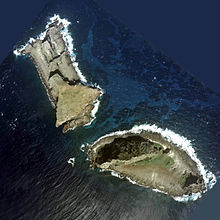 Two of the disputed islets–Kita Kojima (left) and Minami Kojima (right)Main article: Senkaku Islands dispute
The PRC and ROC claim that the islands have been a part of Chinese territory since at least 1534. They acknowledge that Japan took control of the islands in 1894–1895 during the first Sino-Japanese War, through the signature of the Treaty of Shimonoseki. They assert that the Potsdam Declaration (which Japan accepted as part of the San Francisco Peace Treaty) required that Japan relinquish control of all islands except for "the islands of Honshū, Hokkaidō, Kyūshū, Shikoku and such minor islands as we determine", and they state that this means control of the islands should pass to China.
Japan does not accept that there is any ownership dispute, asserting that the islands are an integral part of Japan.[32] Japan has rejected claims that the islands were under China's control prior to 1895, and that these islands were contemplated by the Potsdam Declaration or affected by the San Francisco Peace Treaty.[33]
The controversy has at least two dimensions: (a) territorial sovereignty, which is a legacy of history; and (b) relevant jurisdictional rights and interests in maritime boundaries, which is marked by differing interpretations of the law of the sea.[34]
2010 collision incident
Main article: 2010 Senkaku boat collision incidentOn September 7, 2010, a Chinese fishing boat collided with patrol boats of the Japan Coast Guard near the islands. The trawler was taken by the Japan Coast Guard, and the captain and crew were held in custody in Japan pending possible charges.[35][36] China strongly protested, and demanded an immediate release of the Chinese fishermen.[37] The crew was released on September 13, 2010, while the captain was held until September 24, and none were charged. The incident disrupted official and non-official exchanges and activities between the two countries.
See also
- Sino-Japanese relations
- China Federation for Defending the Diaoyu Islands
- Action Committee for Defending the Diaoyu Islands
- Kuril Islands
- Okinotorishima
- Spratly Islands
- Paracel Islands
Footnotes
- ^ National Geospatial-Intelligence Agency, Senkaku-guntō, Japan, retrieved September 20, 2010.
- ^ National Geospatial-Intelligence Agency, Senkaku-rettō, Japan, retrieved September 20, 2010.
- ^ Lee, Seokwoo. (2002). Territorial Disputes Among Japan, China and Taiwan Concerning the Senkaku Islands, pp. 10–13. at Google Books
- ^ McDorman, Ted L. (2005). "Central Pacific and East Asian Maritime Boundaries" in International Maritime Boundaries, Vol. 5, pp. 3441. at Google Books
- ^ Title: Liang zhong hai dao zhen jing / [Xiang Da jiao zhu].Imprint: Beijing : Zhonghua shu ju : Xin hua shu dian Beijing fa xing suo fa xing, 2000 reprint edition. Contents: Shun feng xiang song--Zhi nan zheng fa. (順風相送--指南正法). ISBN ISBN 7-101-02025-9. pp96 and pp253. The full text is available on wikisource.
- ^ WorldCat, Sangoku Tsūran Zusetsu; alternate romaji Sankoku Tsūran Zusetsu
- ^ Cullen, Louis M. (2003). A History of Japan, 1582–1941: Internal and External Worlds, p. 137. at Google Books
- ^ Klaproth, Julius. (1832). San kokf tsou ran to sets, ou Aperçu général des trois royaumes, pp. 169–180. at Google Books
- ^ Suganuma, Unryu. (2001). Sovereign Rights and Territorial Space in Sino-Japanese Relations, at Google Books
- ^ Belcher, Edward. (1848). Narrative of the Voyage of H.M.S. Samarang, Vol. I, pp. 315. at Google Books; Belcher, Vol. II, pp. 572–574. at Google Books.
- ^ Belcher, Vol. I, at Google Books; excerpt at p. 317, "On the 16th, we endeavoured to obtain observations on Tia-usu; a landing was effected, but the absence of sun prevented our obtaining satisfactory observations, and bad weather coming on hastened our departure. This group, comprehending Hoa-pin-san (Uotsuri Jima), Pinnacle Rocks, and Tias-usu (Kuba Jima), form a triangle, of which the hypothenuse, or distance between Hoa-pin-san and Tia-usu, extends about fourteen miles, and that between Hoa-pinsan and the Southern Pinnacle, about two miles."
- ^ Suganuma, p. 90. at Google Books; Jarrad, Frederick W. (1873). The China Sea Directory, Vol. IV, pp. 141–142. at Google Books
- ^ Hagström, Linus. (2005). Japan's China Policy: A Relational Power Analysis, at Google Books
- ^ Koo, Min Gyo (2009). Disputes and Maritime Regime Building in East Asia, p. 103 n2. citing Park (1973) "Oil under Troubled Waters: The Northeast Asia Seabed Controversy," 14 HILJ (Harvard International Law Journal) 212, 248–249; also Park, Choon-Ho. (1972)Continental Shelf Issues in the Yellow Sea and the East China Sea. Kingston, Rhode Island: Law of the Sea Institute, pp. 1–64.
- ^ a b c d Kaneko, Maya, (Kyodo News) "Ishigaki fishermen fret over Senkaku encroachment", Japan Times, December 8, 2010, p. 3.
- ^ Agence France-Presse, "Senkaku memorial day riles China", Japan Times, December 19, 2010, p. 1. Retrieved January 29, 2011.
- ^ UC Berkeley: UC Institute on Global Conflict and Cooperation; retrieved November 15, 2010.
- ^ Agreement on the Conservation of Albatrosses and Petrals (ACAP), Breeding site details: Agincourt/P'eng-chia-Hsu
- ^ Geospatial Information Authority of Japan (GSI), 魚釣島 (Uotsuri Jima).
- ^ GSI, 久場島 (Kuba Jima).
- ^ GSI, 大正島 (Taishō Jima).
- ^ Google Maps, 南小島 (Minami Kojima)
- ^ Google Maps, 北小島 (Kita Kojima); GSI, 北小島 (Kita Kojima).
- ^ GSI, 沖ノ北岩 (Okino Kitaiwa).
- ^ GSI, 沖ノ南岩 (Okino Minami-iwa).
- ^ GSI, 飛瀬 (Tobise).
- ^ Ji, Guoxing. (1995). "Maritime Jurisdiction in the Three China Seas," p. 11; Sibuet, Jean-Claude et al. "Back arc extension in the Okinawa Trough," Journal of Geophysical Research, Vol. 92, Issue B13, p. 14041-14063.
- ^ a b Ji, p. 11.
- ^ Ji, p. 11; excerpt, "In 1893, Empress Dowager Tsu Shih of the Qing Dynasty issued an imperial edict .... China argues that discovery accompanied by some formal act of usage is sufficient to establish sovereignty over the islands."
- ^ Zoological Society of London, EDGE (Evolutionary Distinct & Globally Endangered) Senkaku mole, 2006; retrieved November 15, 2010.
- ^ Porcasi, Judith F. (1999). "Prehistoric Exploitation of Albatross on the Southern California Channel Islands," Journal of California and Great Basin Anthropology. Vol. 21 (1), pp. 109, citing Hasegawa, Hiroshi. (1979). "Status of the Short-tailed Albatross of Torishimia and in the Senkaku Retto in 1978/79. Pacific Seabird Group Bulletin 6:23–25; and Hasegawa, Hiroshi and Anthony R. Degange. (1982). "The Short-tailed Albatross, 'Diamedea albatrus, Its Status, Distribution and Natural History." American Birds, 36(5):806–814.
- ^ Netherlands Institute for the Law of the Sea (NILOS). (2000). International Organizations and the Law of the Sea, p. 108. at Google Books
- ^ Ji, pp. 11–12, 19.
- ^ Ji, p. 3.
- ^ Wallace, Rick (September 9, 2010). "Chinese fishing boat in diplomatic snare". The Australian. http://www.theaustralian.com.au/news/world/chinese-fishing-boat-in-diplomatic-snare/story-e6frg6so-1225916091902. Retrieved October 8, 2010.
- ^ "High-seas collisions trigger Japan-China spat". Agence France-Presse. Google. September 7, 2010. http://www.google.com/hostednews/afp/article/ALeqM5gfux6suEvEhsCmNJgxMYAYK68ZIQ. Retrieved October 8, 2010.
- ^ Anna, Cara (September 22, 2010). "China premier threatens Japan over boat dispute". Associated Press. Yahoo! News. http://news.yahoo.com/s/ap/20100922/ap_on_re_as/as_china_japan_ships_collide. Retrieved September 22, 2010.
References
- Belcher, Edward and Arthur Adams. (1848). Narrative of the Voyage of H.M.S. Samarang, During the Years 1843–46: Employed Surveying the Islands of the Eastern Archipelago. London : Reeve, Benham, and Reeve. OCLC 192154
- Charney, Jonathan I., David A. Colson, Robert W. Smith. (2005). International Maritime Boundaries, 5 vols. Hotei Publishing: Leiden. 10-ISBN 0792311876/13-ISBN 9780792311874; 10-ISBN 904111954X/13-ISBN 9789041119544; 10-ISBN 9041103457/13-ISBN 9789041103451; 10-ISBN 9004144617/13-ISBN 9789004144613; 10-ISBN 900414479X/13-ISBN 9789004144798; OCLC 23254092
- Findlay, Alexander George. (1889). A Directory for the Navigation of the Indian Archipelago and the Coast of China. London: R. H. Laurie. OCLC 55548028
- Hagström, Linus. (2005). Japan's China Policy: A Relational Power Analysis. London: Routledge. ISBN 9780415346795; OCLC 475020946
- Inoue, Kiyoshi. (1972) Senkaku Letto /Diaoyu Islands The Historical Treatise. Kyoto: Daisan Publisher (出版社: 第三書館) (1996/10)「尖閣」列島―釣魚諸島の史的解明 [単行本]. ISBN 978-4807496129; also hosted in here for online reading (set to Shift-JIS character code), with English synopsis here. Chinese translation by Ying Hui, Published by Commercial Press Hong Kong (1973) 釣魚列島的歷史和主權問題 / 井上清著 ; 英慧譯, ISBN 9622574734.
- Jarrad, Frederick W. (1873). The China Sea Directory, Vol. IV. Comprising the Coasts of Korea, Russian Tartary, the Japan Islands, Gulfs of Tartary and Amúr, and the Sea of Okhotsk. London: Hydrographic Office, Admiralty. OCLC 557221949
- Lee, Seokwoo, Shelagh Furness and Clive Schofield. (2002). Territorial disputes among Japan, China and Taiwan concerning the Senkaku Islands. Durham: University of Durham, International Boundaries Research Unit (IBRU). ISBN 9781897643501; OCLC 249501645
- Suganuma, Unryu. (2000). Sovereign Rights and Territorial Space in Sino-Japanese Relations. Honolulu: University of Hawaii Press. ISBN 9780824821593; OCLC 170955369
- Valencia, Mark J. (2001). Maritime Regime Building: Lessons Learned and Their Relevance for Northeast Asia. The Hague: Martinus Nijhoff. 10-ISBN 9041115803/13-ISBN 9789041115805; OCLC 174100966
Further reading
- Donaldson, John and Alison Williams. "Understanding Maritime Jurisdictional Disputes: The East China Sea and Beyond," Journal of International Affairs, Vol. 59, No. 1.
- Dzurek, Daniel. "The Senkaku/Diaoyu Islands Dispute," International Boundaries Research Unit (IBRU). October 18, 1996.
- Helflin, William B. "Daiyou/Senkaku Islands Dispute: Japan and China, Oceans Apart," 1 Asian-Pacific Law & Policy Journal 1–22 (2000).
- Peterson, Alexander M. "Sino-Japanese Cooperation in the East China Sea: A Lasting Arrangement?" 42 Cornell International Law Journal 441–474 (2009).
- Ramos-Mrosovsky, Carlos. "International Law's Unhelpful Role in the Senkaku Islands,", 29 University of Pennsylvania Journal of International Law 903-946 (2008).
External links
- Google maps, Senkaku Islands
- "Q&A China Japan island row," BBC News Asia-Pacific. September 24, 2010.
- Globalsecurity.org — "Senkaku/Diaoyutai Islands"; References, Links
- Inventory of Conflict and Environment (ICE), Diaoyu Islands Dispute
- Waseda University — Hayashi Shihei. (1785). 三国通覧図説 (Sangoku Tsuran Zusetsu)
Categories:- Archipelagoes of Japan
- Cross-Strait relations
- Disputed islands
- Uninhabited islands of China
- Uninhabited islands of Japan
- Islands of Taiwan
- Territorial disputes of Japan
- Territorial disputes of the People's Republic of China
- Territorial disputes of the Republic of China


Wikimedia Foundation. 2010.