- Aksai Chin
-
Coordinates: 35°7′N 79°8′E / 35.117°N 79.133°E
Aksai Chin 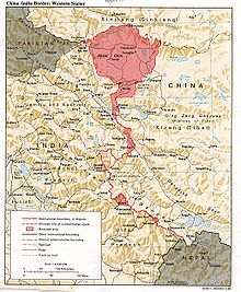
India - China border showing Aksai Chin (अक्साई चिन) Traditional Chinese 阿克賽欽 Simplified Chinese 阿克赛钦 Transcriptions Mandarin - Hanyu Pinyin Ākèsàiqīn Aksai Chin (Hindi: अक्साई चिन; Urdu: اکسائی چن; Chinese: 阿克赛钦; pinyin: Ākèsàiqīn) is one of the two main disputed border areas between the People's Republic of China and India, the other being South Tibet. It is administered by China as part of Hotan County in the Hotan Prefecture of Xinjiang Autonomous Region, but is also claimed by India as a part of the Ladakh district of the state of Jammu and Kashmir. In 1962 China and India fought a brief war over Aksai Chin and South Tibet, but in 1993 and 1996 the two countries signed agreements to respect the Line of Actual Control.[1]
Contents
Geography
Aksai Chin is one of the two main disputed border areas between India and the People's Republic of China, the other being Arunachal Pradesh, whose claim in 1914 and seizure in 1947 by the British Empire the Chinese government does not recognize. India claims Aksai Chin as the eastern-most part of the Jammu and Kashmir state. The line that separates Indian-administered areas of Jammu and Kashmir from Aksai Chin is known as the Line of Actual Control (LAC) and is concurrent with the Chinese Aksai Chin claim line.
The etymology of Aksai Chin is uncertain regarding the word "Chin". As a word of Turk origin, aksai literally means "white brook" but whether the word Chin refers to Chinese or pass is disputed. The area is largely a vast high-altitude desert including some salt lakes from 4,800 metres (15,700 ft) to 5,500 metres (18,000 ft) above sea level. It covers an area of 37,244 square kilometres (14,380 sq mi).
The Chinese spelling of the region's name, 阿克赛钦, is composed of Chinese characters chosen for their phonetic values,[2] irrespective of their meaning.
Topographically, Aksai Chin is a high altitude desert. In the southwest, the Karakoram range form the de facto border (Line of Actual Control) between Aksai Chin and Indian-controlled Kashmir. Glaciated peaks in the mid portion of this boundary reach heights of 6,950 metres (22,800 ft).
In the north, the Kunlun Range separates Aksai Chin from the Tarim Basin, where the rest of Hotan County is situated. According to a recent detailed Chinese map, no roads cross the Kunlun Range within Hotan Prefecture, and only one track does so, over the Hindutash Pass.[3]
The northern part of Aksai Chin is referred to as the Soda Plain and contains Aksai Chin's largest river, the Karakosh, The river, which receives meltwater from a number of glaciers, crosses the Kunlun farther northwest, in Pishan County and enters the Tarim Basin, where it serves as one of the main sources of water for Karakax and Hotan Counties.
The eastern part of the region contains several small endorheic basins. The largest of them is that of the Aksai Chin Lake, which is fed by the river of the same name.
The region is almost uninhabited, has no permanent settlements, and receives little precipitation as the Himalayas and the Karakoram block the rains from the Indian monsoon.
History

At an elevation of 5,000m, the desolation of Aksai Chin had no human importance other than an ancient trade route that crossed over it, providing a brief pass during summer for caravans of yaks between Xinjiang and Tibet.[4]
One of the earliest treaties regarding the boundaries in the western sector was issued in 1842. The Sikh Confederacy of the Punjab region in India had annexed Ladakh into the state of Jammu in 1834. In 1841, they invaded Tibet with an army. Chinese forces defeated the Sikh army and in turn entered Ladakh and besieged Leh. After being checked by the Sikh forces, the Chinese and the Sikhs signed a treaty in September 1842, which stipulated no transgressions or interference in the other country's frontiers.[5] The British defeat of the Sikhs in 1846 resulted in transfer of sovereignty over Ladakh to the British, and British commissioners attempted to meet with Chinese officials to discuss the border they now shared. However, both sides were apparently sufficiently satisfied that a traditional border was recognized and defined by natural delements, and the border was not demarcated.[5] The boundaries at the two extremities, Pangong Lake and Karakoram Pass, were well-defined, but the Aksai Chin area in between lay undefined.[4][6]
The Johnson Line
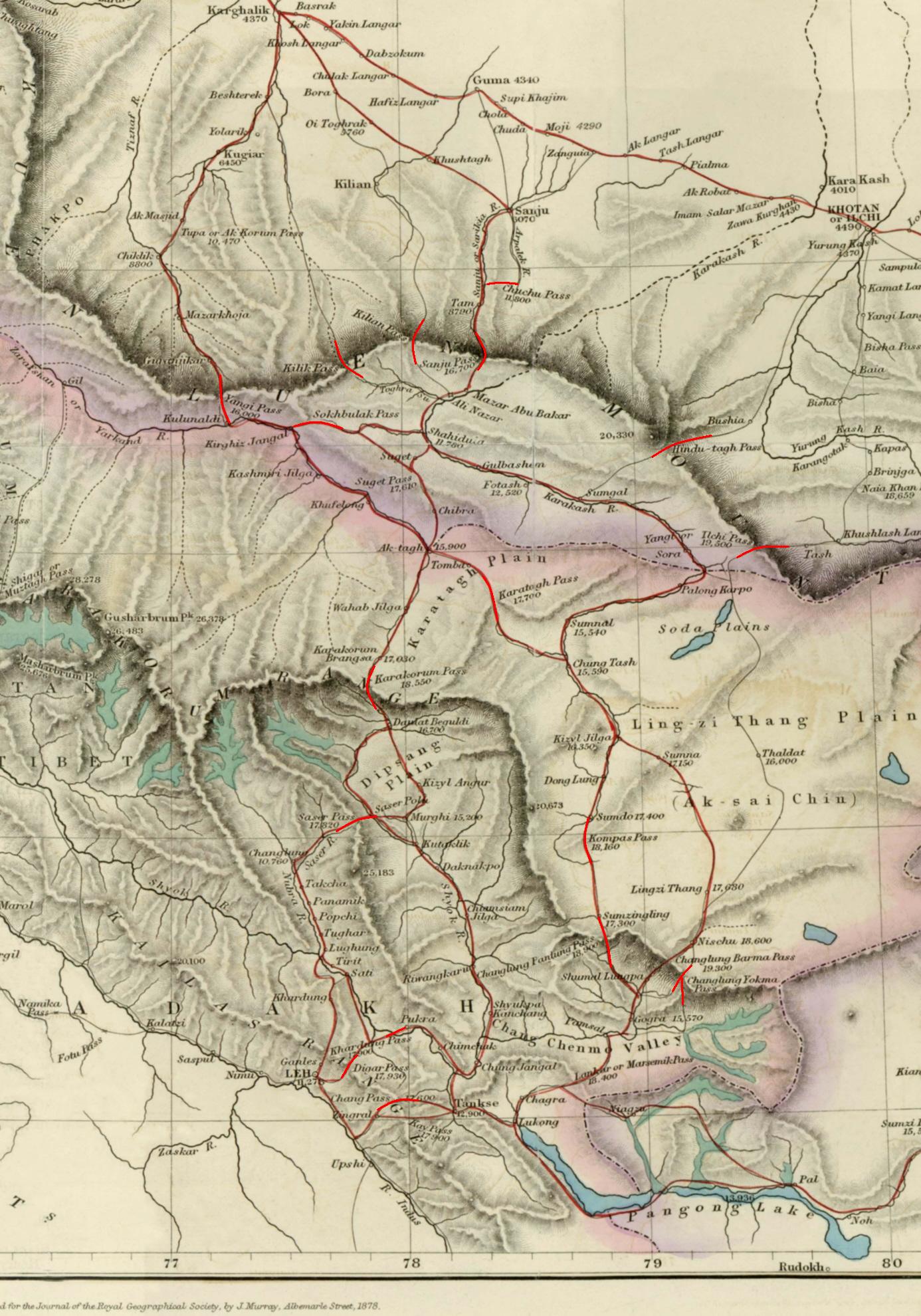
 Map of Central Asia (1878) showing Khotan (near top right corner). The previous border claimed by the British Indian Empire is shown in the two-toned purple and pink band with Shahidulla and the Kilik, Kilian and Sanju Passes clearly north of the border.
W. H. Johnson, a civil servant with the Survey of India proposed the "Johnson Line" in 1865, which put Aksai Chin in Kashmir.[7] This was the time of the Dungan revolt, when China did not control Xinjiang, so this line was never presented to the Chinese.[7] Johnson presented this line to the Maharaja of Kashmir, who then claimed the 18,000 square kilometres contained within,[7] and by some accounts territory further north as far as the Sanju Pass in the Kun Lun Mountains. Johnson's work was severely criticized for gross inaccuracies, with description of his boundary as "patently absurd".[8] Johnson was reprimanded by the British Government and resigned from the Survey.[8][7][9] The Maharajah of Kashmir apparently sent a few soldiers to man the abandoned fort at Shahidulla (modern-day Xaidulla) at one point, by the time most sources placed Shahidulla and the upper Karakash River firmly within the territory of Xinjiang (see accompanying map). According to Francis Younghusband, who explored the region in the late 1880s, there was only an abandoned fort and not one inhabited house at Shahidulla when he was there - it was just a convenient staging post and a convenient headquarters for the nomadic Kirghiz.[10] The abandoned fort had apparently been built a few years earlier by the Kashmiris.[11] In 1878 the Chinese had reconquered Xinjiang, and by 1890 they already had Shahidulla before the issue was decided.[7] By 1892, China had erected boundary markers at Karakoram Pass.[8]
In 1897 a British military officer, Sir John Ardagh, proposed a boundary line along the crest of the Kun Lun Mountains north of the Yarkand River.[12] At the time Britain was concerned at the danger of Russian expansion as China weakened, and Ardagh argued that his line was more defensible. The Ardagh line was effectively a modification of the Johnson line, and became known as the "Johnson-Ardagh Line".
The Macartney-Macdonald Line
In the 1890s Britain and China were allies and Britain was principally concerned that Aksai Chin not fall into Russian hands.[7] In 1899, when China showed an interest in Aksai Chin, Britain proposed a revised boundary, initially suggested by George Macartney,[8] which put most of Aksai Chin in Chinese territory.[7] This border, along the Karakoram Mountains, was proposed and supported by British officials for a number of reasons. The Karakoram Mountains formed a natural boundary, which would set the British borders up to the Indus River watershed while leaving the Tarim River watershed in Chinese control, and Chinese control of this tract would present a further obstacle to Russian advance in Central Asia.[9] The British presented this line to the Chinese in a Note by Sir Claude MacDonald. The Chinese did not respond to the Note, and the British took that as Chinese acquiescence.[7] This line, known as the Macartney-MacDonald line, is approximately the same as the current Line of Actual Control.[7]
1899 to 1947
Both the Johnson-Ardagh and the Macartney-MacDonald lines were used on British maps of India.[7] Until at least 1908, the British took the Macdonald line to be the boundary,[13] but in 1911, the Xinhai Revolution resulted in the collapse of central power in China, and by the end of World War I, the British officially used the Johnson Line. However they took no steps to establish outposts or assert actual control on the ground.[8] In 1927, the line was adjusted again as the government of British India abandoned the Johnson line in favor of a line along the Karakoram range further south.[8] However, the maps were not updated and still showed the Johnson Line.[8]
When British officials learned of Soviet officials surveying the Aksai Chin for Sheng Shicai, warlord of Xinjiang in 1940-1941, they again advocated the Johnson Line.[7] At this point the British had still made no attempts to establish outposts or control over the Aksai Chin, nor was the issue ever discussed with the governments of China or Tibet, and the boundary remained undemarcated at India's independence.[7][8]
Since 1947
Upon independence in 1947, the government of India used the Johnson Line as the basis for its official boundary in the west, which included the Aksai Chin[8] From the Karakoram Pass (which is not under dispute), the Indian claim line extends northeast of the Karakoram Mountains through the salt flats of the Aksai Chin, to set a boundary at the Kunlun Mountains, and incorporating part of the Karakash River and Yarkand River watersheds. From there, it runs east along the Kunlun Mountains, before turning southwest through the Aksai Chin salt flats, through the Karakoram Mountains, and then to Panggong Lake.[4]
On July 1, 1954 Prime Minister Nehru wrote a memo directing that the maps of India be revised to show definite boundaries on all frontiers. Up to this point, the boundary in the Aksai Chin sector, based on the Johnson Line, had been described as "undemarcated."[9]
During the 1950s, the People's Republic of China built a 1,200 km (750 mi) road connecting Xinjiang and western Tibet, of which 179 km (112 mi) ran south of the Johnson Line through the Aksai Chin region claimed by India.[4][7][8] Aksai Chin was easily accessible to the Chinese, but was more difficult for the Indians on the other side of the Karakorams to reach.[4] The Indians did not learn of the existence of the road until 1957, which was confirmed when the road was shown in Chinese maps published in 1958.[14]
The Indian position, as stated by prime minister Jawalharlal Nehru, was that the Aksai Chin was "part of the Ladakh region of India for centuries" and that this northern border was a "firm and definite one which was not open to discussion with anybody".[4]
The Chinese minister, Zhou Enlai argued that the western border had never been delimited, that the Macartney-MacDonald Line, which left the Aksai Chin within Chinese borders was the only line ever proposed to a Chinese government, and that the Aksai Chin was already under Chinese jurisdiction, and that negotiations should take into account the status quo.[4]
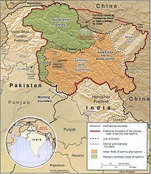
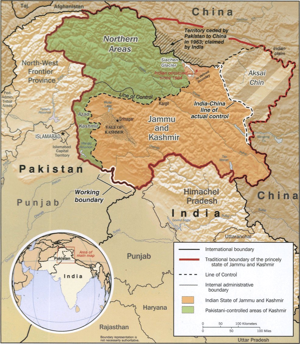
Trans Karakoram Tract
Main article: Trans Karakoram TractThe Johnson Line is not used west of the Karakoram Pass, where China adjoins Pakistan-administered Gilgit-Baltistan. On October 13, 1962, China and Pakistan began negotiations over the boundary west of the Karakoram Pass. In 1963, the two countries settled their boundaries largely on the basis of the Macartney-MacDonald Line, which left the Trans Karakoram Tract in China, although the agreement provided for renegotiation in the event of a settlement of the Kashmir dispute. India does not recognise that Pakistan and China have a common border, and claims the tract as part of the domains of the pre-1947 state of Kashmir and Jammu. However, India's claim line in that area does not extend as far north of the Karakoram Mountains as the Johnson Line[4]
Strategic Importance
China National Highway 219 runs through Aksai Chin connecting Lazi and Xinjiang in the Tibet Autonomous Region. Despite this region being nearly uninhabitable and having no resources, it remains strategically important for China as it connects Tibet and Xinjiang. Construction started in 1951 and the road was completed in 1957. The construction of this highway was one of the triggers for the Sino-Indian War of 1962.[citation needed]
Chinese terrain model
In June 2006, satellite imagery on the Google Earth service revealed a 1:500[15] scale terrain model [1] of eastern Aksai Chin and adjacent Tibet, built near the town of Huangyangtan, about 35 kilometres (22 mi) southwest of Yinchuan, the capital of the autonomous region of Ningxia in China.[16] A visual side-by-side comparison shows a very detailed duplication of Aksai Chin in the camp.[17] The 900 × 700 m (3,000 × 2,300 ft)[citation needed] model was surrounded by a substantial facility, with rows of red-roofed buildings, scores of olive-colored trucks and a large compound with elevated lookout posts and a large communications tower. Such terrain models are known to be used in military training and simulation, although usually on a much smaller scale.
Local authorities in Ningxia point out that their model of Aksai Chin is part of a tank training ground, built in 1998 or 1999.[15]
See also
- South Tibet
References
- ^ "India-China Border Dispute". GlobalSecurity.org. http://www.globalsecurity.org/military/world/war/india-china_conflicts.htm.
- ^ All these characters can be seen in Chinese Wikipedia's standard transcription table for foreign names, which in its turn is based on the standard transcription guide, 世界人名翻译大辞典 (The Great Dictionary of Foreign Personal Names' Translations), 1993, ISBN 7-5001-0221-6(first edition); 1997, ISBN 7-5001-0799-4 (revised edition)
- ^ Xinjiang Uyghur Autonomous Region Road Atlas (中国分省公路丛书:新疆维吾尔自治区), published by 星球地图出版社 Xingqiu Ditu Chubanshe, 2008, ISBN 978-7-80212-469-1. Map of Hotan Prefecture, pp. 18-19.
- ^ a b c d e f g h Maxwell, Neville, India's China War, New York, Pantheon, 1970.
- ^ a b The Sino-Indian Border Disputes, by Alfred P. Rubin, The International and Comparative Law Quarterly, Vol. 9, No. 1. (Jan., 1960), pp. 96-125.
- ^ Guruswamy, Mohan (January 2006). Emerging Trends in India-China Relations. India: Hope India Publications. p. 222. ISBN 9788178711010. http://books.google.com/books?id=trAb0KxP_ocC&pg=PA222. Retrieved 2009-09-12.
- ^ a b c d e f g h i j k l m Mohan Guruswamy, Mohan, "The Great India-China Game", Rediff, June 23, 2003.
- ^ a b c d e f g h i j Calvin, James Barnard (April 1984). "The China-India Border War". Marine Corps Command and Staff College. http://www.globalsecurity.org/military/library/report/1984/CJB.htm. Retrieved 2011-10-14.
- ^ a b c Noorani, A.G. (30 August-12 September 2003), "Fact of History", Frontline (Madras: The Hindu group) 26 (18), http://frontlineonnet.com/fl2018/stories/20030912002104800.htm, retrieved 24 August 2011
- ^ Younghusband, Francis E. (1896). The Heart of a Continent. John Murray, London. Facsimile reprint: (2005) Elbiron Classics, pp. 223-224.
- ^ Grenard, Fernand (1904). Tibet: The Country and its Inhabitants. Fernand Grenard. Translated by A. Teixeira de Mattos. Originally published by Hutchison and Co., London. 1904. Reprint: Cosmo Publications. Delhi. 1974, pp. 28-30.
- ^ Woodman, Dorothy (1969). Himalayan Frontiers. Barrie & Rockcliff. pp. 101 and 360ff.
- ^ Woodman (1969), p.79
- ^ China's Decision for War with India in 1962 by John W. Garver
- ^ a b "Chinese X-file not so mysterious after all". Melbourne: The Age. 2006-07-23. http://www.theage.com.au/news/web/chinese-xfile-not-so-mysterious-after-all/2006/07/23/1153593217781.html. Retrieved 2008-12-17.
- ^ Indian Express website
- ^ Google Earth Community posting, 10 April 2007
External links
- China and Kashmir, by Jabin T. Jacob, published in The Future of Kashmir, special issue of ACDIS Swords and Ploughshares, Program in Arms Control, Disarmament, and International Security, University of Illinois, winter 2007-8.
- China, India, and the fruits of Nehru's folly by Venkatesan Vembu, Daily News & Analysis, 6 June 2007
- Facing the truth Pakistan has solved its border problem with China, but India is caught in a prolonged dispute.
- The Great China-India Game An informative history of the always-ambiguous China-India border in Aksai Chin.
- Conflict in Kashmir: Selected Internet Resources by the Library, University of California, Berkeley, USA; University of California, Berkeley Library Bibliographies and Web-Bibliographies list
- Satellite image of large scale terrain model of Aksai Chin
- Diagram explaining the situation
- Landscape photos of Aksai Chin by a cyclist
- Why China is playing hardball in Arunachal by Venkatesan Vembu, Daily News & Analysis, 13 May 2007
Categories:- Independent India
- History of Jammu and Kashmir
- Territorial disputes of the People's Republic of China
- Kashmir
- Geography of Xinjiang
- Territorial disputes of India
- China–India relations

Wikimedia Foundation. 2010.