- Origins of the Sino-Indian border dispute
-
Sovereignty over two separated pieces of territory was contested during the Sino-Indian War. One is Aksai Chin is located either in the Indian province of Kashmir or the Chinese province of Xinjiang in the west. It is a virtually uninhabited high-altitude wasteland crossed by the Xinjiang-Tibet Highway. The other disputed area lies to the east is referred to as Arunachal Pradesh by India and South Tibet by China. It is a sparsely inhabited area with numerous local tribes.
Contents
Aksai Chin
Main article: Aksai Chin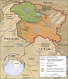 The western portion of the disputed boundary.
At 17,000 feet elevation, the desolation of Aksai Chin had no human importance other than an ancient trade route that crossed over it, providing a brief pass during summer for caravans of yaks between Xinjiang and Tibet.[1]
One of the earliest treaties regarding the boundaries in the western sector was issued in 1842. The Sikh Confederacy of the Punjab region in India had annexed Ladakh into the state of Jammu in 1834. In 1841, they invaded Tibet with an army. Chinese forces defeated the Sikh army and in turn entered Ladakh and besieged Leh. After being checked by the Sikh forces, the Chinese and the Sikhs signed a treaty in September 1842, which stipulated no transgressions or interference in the other country's frontiers.[2] The British defeat of the Sikhs in 1846 resulted in transfer of sovereignty over Ladakh to the British, and British commissioners attempted to meet with Chinese officials to discuss the border they now shared. However, both sides were apparently sufficiently satisfied that a traditional border was recognized and defined by natural delements, and the border was not demarcated.[2] The boundaries at the two extremities, Pangong Lake and Karakoram Pass, were well-defined, but the Aksai Chin area in between lay undefined.[1][3]
The Johnson Line
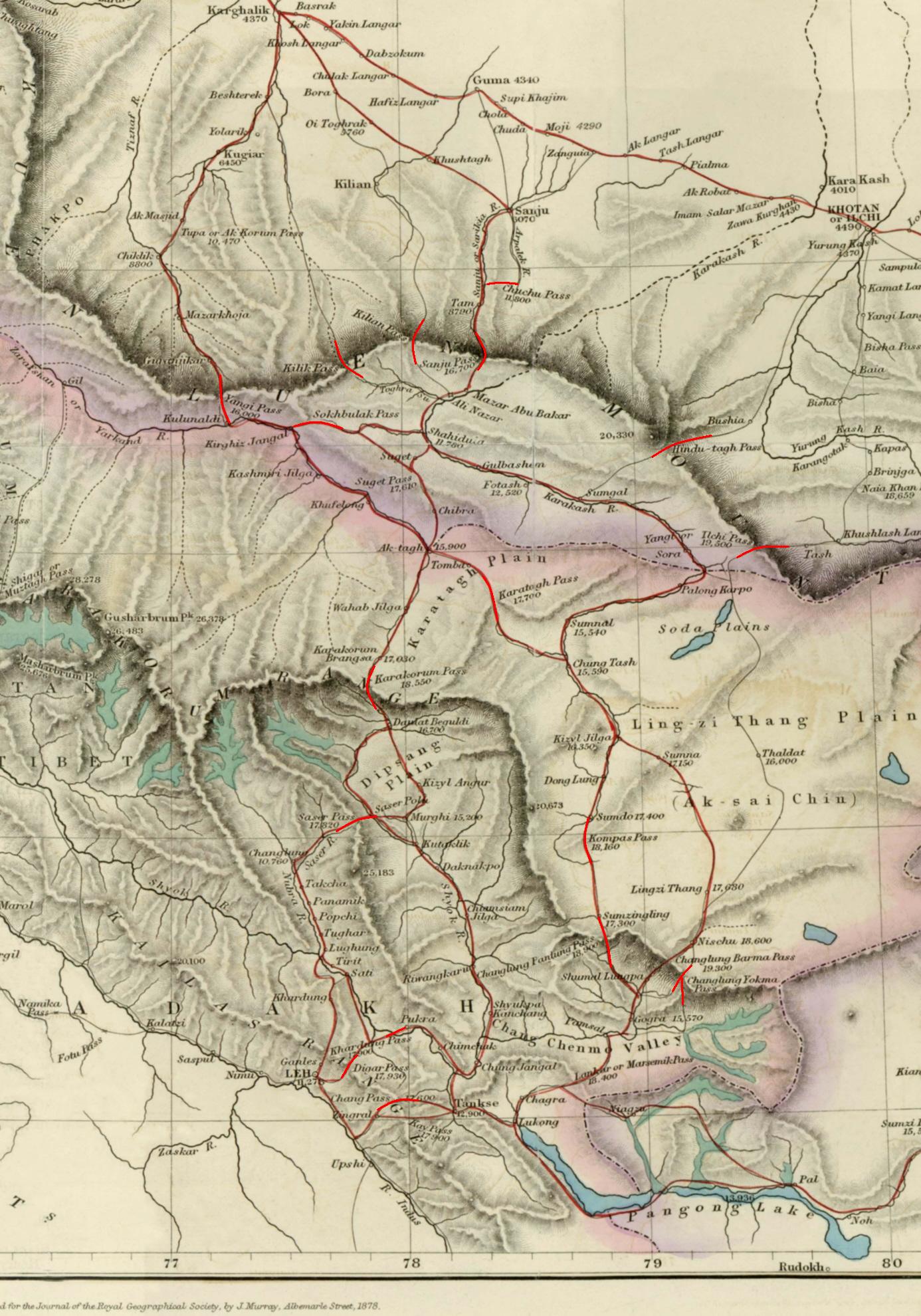
 Map of Central Asia (1878) showing Khotan (near top right corner). The previous border claimed by the British Indian Empire is shown in the two-toned purple and pink band with Shahidulla and the Kilik, Kilian and Sanju Passes clearly north of the border.
W. H. Johnson, a civil servant with the Survey of India proposed the "Johnson Line" in 1865, which put Aksai Chin in Kashmir.[4] This was the time of the Dungan revolt, when China did not control Xinjiang, so this line was never presented to the Chinese.[4] Johnson presented this line to the Maharaja of Kashmir, who then claimed the 18,000 square kilometres contained within,[4] and by some accounts territory further north as far as the Sanju Pass in the Kun Lun Mountains. Johnson's work was severely criticized for gross inaccuracies, with description of his boundary as "patently absurd",[5] and he was reprimanded by the British Government and resigned from the Survey.[5][4][6] The Maharajah of Kashmir apparently sent a few soldiers to man the abandoned fort at Shahidulla (modern-day Xaidulla) at one point, by the time most sources placed Shahidulla and the upper Karakash River firmly within the territory of Xinjiang (see accompanying map). According to Francis Younghusband, who explored the region in the late 1880s, there was only an abandoned fort and not one inhabited house at Shahidulla when he was there - it was just a convenient staging post and a convenient headquarters for the nomadic Kirghiz.[7] The abandoned fort had apparently been built a few years earlier by the Kashmiris.[8] In 1878 the Chinese had reconquered Xinjiang, and by 1890 they already had Shahidulla before the issue was decided.[4] By 1892, China had erected boundary markers at Karakoram Pass.[5]
In 1897 a British military officer, Sir John Ardagh, proposed a boundary line along the crest of the Kun Lun Mountains north of the Yarkand River.[9] At the time Britain was concerned at the danger of Russian expansion as China weakened, and Ardagh argued that his line was more defensible. The Ardagh line was effectively a modification of the Johnson line, and became known as the "Johnson-Ardagh Line".
The Macartney-Macdonald Line
In the 1890s Britain and China were allies and Britain was principally concerned that Aksai Chin not fall into Russian hands.[4] In 1899, when China showed an interest in Aksai Chin, Britain proposed a revised boundary, initially suggested by George Macartney,[5] which put most of Aksai Chin in Chinese territory.[4] This border, along the Karakoram Mountains, was proposed and supported by British officials for a number of reasons. The Karakoram Mountains formed a natural boundary, which would set the British borders up to the Indus River watershed while leaving the Tarim River watershed in Chinese control, and Chinese control of this tract would present a further obstacle to Russian advance in Central Asia.[6] The British presented this line to the Chinese in a Note by Sir Claude MacDonald. The Chinese did not respond to the Note, and the British took that as Chinese acquiescence.[4] This line, known as the Macartney-MacDonald line, is approximately the same as the current Line of Actual Control.[4]
1899 to 1947
Both the Johnson-Ardagh and the Macartney-MacDonald lines were used on British maps of India.[4] Until at least 1908, the British took the Macdonald line to be the boundary,[10] but in 1911, the Xinhai Revolution resulted in the collapse of central power in China, and by the end of World War I, the British officially used the Johnson Line. However they took no steps to establish outposts or assert actual control on the ground.[5] In 1927, the line was adjusted again as the government of British India abandoned the Johnson line in favor of a line along the Karakoram range further south.[5] However, the maps were not updated and still showed the Johnson Line.[5]
When British officials learned of Soviet officials surveying the Aksai Chin for Sheng Shicai, warlord of Xinjiang in 1940-1941, they again advocated the Johnson Line.[4] At this point the British had still made no attempts to establish outposts or control over the Aksai Chin, nor was the issue ever discussed with the governments of China or Tibet, and the boundary remained undemarcated at India's independence.[4][5]
Since 1947
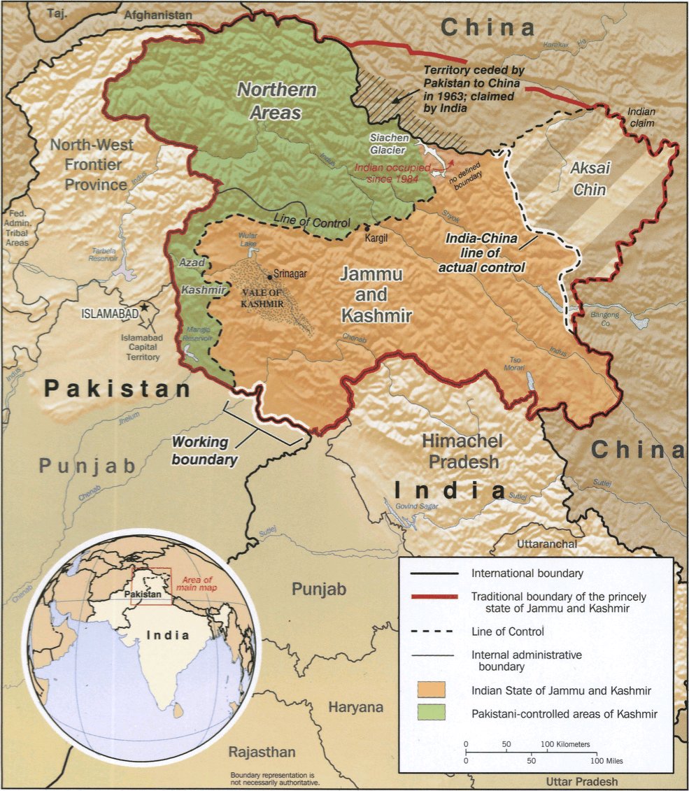
Upon independence in 1947, the government of India used the Johnson Line as the basis for its official boundary in the west, which included the Aksai Chin[5] From the Karakoram Pass (which is not under dispute), the Indian claim line extends northeast of the Karakoram Mountains through the salt flats of the Aksai Chin, to set a boundary at the Kunlun Mountains, and incorporating part of the Karakash River and Yarkand River watersheds. From there, it runs east along the Kunlun Mountains, before turning southwest through the Aksai Chin salt flats, through the Karakoram Mountains, and then to Panggong Lake.[1]
On July 1, 1954 Prime Minister Nehru wrote a memo directing that the maps of India be revised to show definite boundaries on all frontiers. Up to this point, the boundary in the Aksai Chin sector, based on the Johnson Line, had been described as "undemarcated."[6]
During the 1950s, the People's Republic of China built a 1,200 km (750 mi) road connecting Xinjiang and western Tibet, of which 179 km (112 mi) ran south of the Johnson Line through the Aksai Chin region claimed by India.[1][4][5] Aksai Chin was easily accessible to the Chinese, but was more difficult for the Indians on the other side of the Karakorams to reach.[1] The Indians did not learn of the existence of the road until 1957, which was confirmed when the road was shown in Chinese maps published in 1958.[11]
The Indian position, as stated by prime minister Jawalharlal Nehru, was that the Aksai Chin was "part of the Ladakh region of India for centuries" and that this northern border was a "firm and definite one which was not open to discussion with anybody".[1]
The Chinese minister, Zhou Enlai argued that the western border had never been delimited, that the Macartney-MacDonald Line, which left the Aksai Chin within Chinese borders was the only line ever proposed to a Chinese government, and that the Aksai Chin was already under Chinese jurisdiction, and that negotiations should take into account the status quo.[1]
Trans Karakoram Tract
Main article: Trans Karakoram TractThe Johnson Line is not used west of the Karakoram Pass, where China adjoins Pakistan-administered Gilgit-Baltistan. On October 13, 1962, China and Pakistan began negotiations over the boundary west of the Karakoram Pass. In 1963, the two countries settled their boundaries largely on the basis of the Macartney-MacDonald Line, which left the Trans Karakoram Tract in China, although the agreement provided for renegotiation in the event of a settlement of the Kashmir dispute. India does not recognise that Pakistan and China have a common border, and claims the tract as part of the domains of the pre-1947 state of Kashmir and Jammu. However, India's claim line in that area does not extend as far north of the Karakoram Mountains as the Johnson Line[1]
The McMahon Line
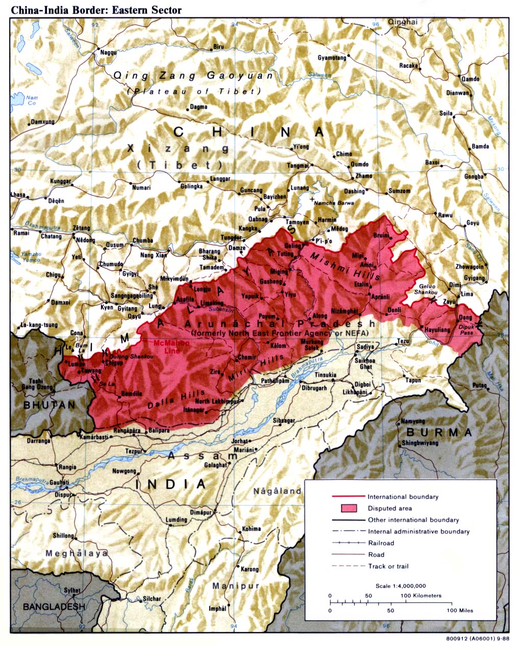
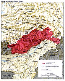 The McMahon Line is the red line marking the northern boundary of the disputed area.Main article: McMahon Line
British India and China gained a common border in 1826, with British annexation of Assam in the Treaty of Yandabo at the conclusion of the First Anglo-Burmese War (1824–1826). Subsequent annexations in further Anglo-Burmese Wars expanded China's borders with British India eastwards, to include the border with what is now Myanmar.
In 1913-14, representatives of Britain, China, and Tibet attended a conference in Simla, India and drew up an agreement concerning Tibet's status and borders. The McMahon Line, a proposed boundary between Tibet and India for the eastern sector, was drawn by British negotiator Henry McMahon on a map attached to the agreement. All three representatives initiated the agreement, but Beijing immediately objected to the proposed Sino-Tibet boundary and repudiated the agreement. After approving a note which stated that China could not enjoy rights under the agreement unless she ratified it, the British and Tibetan negotiators signed the Simla Convention as a bilateral accord. Neville Maxwell states that McMahon had been instructed not to sign bilaterally with Tibetans if China refused, but he did so without the Chinese representative present and then kept the declaration secret.[1]
V.K. Singh argues that the basis of these boundaries, accepted by British India and Tibet, were that the historical boundaries of India were the Himalayas and the areas south of the Himalayas were traditionally Indian and associated with India.[12] The high watershed of the Himalayas was proposed as the border between India and its northern neighbours.[12] India's government held the view that the Himalayas were the ancient boundaries of the Indian subcontinent and thus should be the modern boundaries of British India and later the Republic of India.[12]
Chinese boundary markers, including one set up by the newly created Chinese Republic, stood near Walong until January 1914, when T. O'Callaghan, an assistant administrator of NEFA's eastern sector, relocated them north to locations closer to the McMahon Line (albeit still South of the Line).[5] He then went to Rima, met with Tibetan officials, and saw no Chinese influence in the area.[5]
By signing the Simla Agreement with Tibet, the British had violated the Anglo-Russian Convention of 1907, in which both parties were not to negotiate with Tibet, "except through the intermediary of the Chinese Government", as well as the Anglo-Chinese Convention of 1906, which bound the British government "not to annex Tibetan territory."[13] Because of doubts concerning the legal status of the accord, the British did not put the McMahon Line on their maps until 1937, nor did they publish the Simla Convention in the treaty record until 1938. Rejecting Tibet's 1913 declaration of independence, China argued that the Simla Convention and McMahon Line were illegal and that Tibetan government was merely a local government without treaty-making powers. In 1947, Tibet requested that India recognize Tibetan authority in the trading town of Tawang, south of the McMahon Line. Tibet did not object to any other portion of the McMahon line. In reply, the Indians asked Tibet to continue the relationship on the basis of the previous British Government.[1]
Tibetan officials continued to administer Tawang and refused to concede territory during negotiations in 1938.[5] The governor of Assam asserted that Tawang was "undoubtedly British" but noted that it was "controlled by Tibet, and none of its inhabitants have any idea that they are not Tibetan."[5] During World War II, with India's east threatened by Japanese troops and with the threat of Chinese expansionism, British troops secured Tawang for extra defense.[5]
China's claim on areas south of the McMahon Line, encompassed in the North East Frontier Agency, were based on traditional boundaries.[12] India believes that the boundaries China proposed in Ladakh and Arunachal Pradesh have no written basis and no documentation of acceptance by anyone apart from China.[12] Indians argue that China claims the territory on the basis that it was under Chinese imperial control in the past,[12] while Chinese argue that India claims the territory on the basis that it was under British imperial control in the past[14] The last Qing emperor's 1912 edict of abdication authorized its succeeding republican government to form a union of "five peoples, namely, Manchus, Han Chinese, Mongols, Muslims, and Tibetans together with their territory in its integrity"[15] However, V.K. Singh cites the presence of the Mauryan Empire and Chola Dynasty in regions India does not place a claim to but which were heavily influenced by Indian culture.[12]
Parts of India's claim line in the eastern sector follows a modified version of the McMahon Line. The original line drawn up by Henry McMahon on the Simla Treaty map starts at 27°44’30’’N, starting a trijunction between Bhutan, China, and India, and from there, extends eastwards.[1] Most of the fighting in the eastern sector before the start of the war would take place north of this line.[5][16] However, India claims that the intent of the treaty was to follow the highest ridges of the Himalayas. They claimed that South of the high ridges should be Indian territory and North of the high ridges should be Chinese territory. In the Indian claim, the two armies would be separated from each other by the highest mountains in the world.
Starting from the 1950s, when India began patrolling this area, they found that they at multiple locations, the highest ridges fell north of the McMahon Line as shown in the treaty map and their own maps, and they modified their maps to extend northwards to include features such as Thag La, Longju, and Khinzemane as Indian territory.[1] Thus, the Indian version of the McMahon Line moves the Bhutan-China-India trijunction north to 27°48’N.[1] India would claim that the treaty map ran along features such as Thag La, though the actual treaty map itself is topographically vague (as the treaty was not accompanied with demarcation), and the treaty includes no verbal description of geographic features nor description of the highest ridges.[1][17]
See also
References
- ^ a b c d e f g h i j k l m n Maxwell, Neville, India's China War, New York, Pantheon, 1970.
- ^ a b The Sino-Indian Border Disputes, by Alfred P. Rubin, The International and Comparative Law Quarterly, Vol. 9, No. 1. (Jan., 1960), pp. 96-125.
- ^ Guruswamy, Mohan (January 2006). Emerging Trends in India-China Relations. India: Hope India Publications. p. 222. ISBN 9788178711010. http://books.google.com/books?id=trAb0KxP_ocC&pg=PA222. Retrieved 2009-09-12.
- ^ a b c d e f g h i j k l m Mohan Guruswamy, Mohan, "The Great India-China Game", Rediff, June 23, 2003.
- ^ a b c d e f g h i j k l m n o p Calvin, James Barnard (April 1984). "The China-India Border War". Marine Corps Command and Staff College. http://www.globalsecurity.org/military/library/report/1984/CJB.htm. Retrieved 2011-10-14.
- ^ a b c Noorani, A.G. (30 August-12 September 2003), "Fact of History", Frontline (Madras: The Hindu group) 26 (18), http://frontlineonnet.com/fl2018/stories/20030912002104800.htm, retrieved 24 August 2011
- ^ Younghusband, Francis E. (1896). The Heart of a Continent. John Murray, London. Facsimile reprint: (2005) Elbiron Classics, pp. 223-224.
- ^ Grenard, Fernand (1904). Tibet: The Country and its Inhabitants. Fernand Grenard. Translated by A. Teixeira de Mattos. Originally published by Hutchison and Co., London. 1904. Reprint: Cosmo Publications. Delhi. 1974, pp. 28-30.
- ^ Woodman, Dorothy (1969). Himalayan Frontiers. Barrie & Rockcliff. pp. 101 and 360ff.
- ^ Woodman (1969), p.79
- ^ China's Decision for War with India in 1962 by John W. Garver
- ^ a b c d e f g VK Singh resolving the boundary dispute
- ^ Karunakar Gupta. "The McMahon Line 1911-45: The British Legacy". The China Quarterly, No. 47. (Jul. - Sep., 1971), pp. 521-545.
- ^ "The Place of International Law in Chinese Strategy and Tactics: The Case of the Sino-Indian Boundary Dispute", by Arthur A. Stahnke. The Journal of Asian Studies. Vol. 30, No. 1, Nov 1970. pg. 95-119
- ^ Qing Dynasty Edict of Abdication, translated by Bertram Lenox Putnam Weale, The Fight For The Republic in China, London: Hurst & Blackett, Ltd. Paternoster House, E.C. 1918. - Emphasis added, "Muslims" rendered as "Mohammedans" in original translation
- ^ A.G. Noorani, "Perseverance in peace process". India's National Magazine, August 29, 2003.
- ^ Tawang and "The Un-Negotiated Dispute", T. S. Murty, Neville Maxwell. The China Quarterly, No. 46. (Apr. - Jun., 1971), pp. 357-362.
Categories:- Sino-Indian War
- Causes of war
- China–India border
Wikimedia Foundation. 2010.