- National Highway 1D (India)
-
National Highway 1D

1D
Route information Length: 422 km (262 mi) Major junctions From: Srinagar, Jammu & Kashmir NH 1A in Srinagar To: Leh, Ladakh Location States: Jammu & Kashmir: 422 km (262 mi) Primary
destinations:Srinagar - Zoji La - Kargil - Leh Highway system Indian Road Network
National • Expressways • State
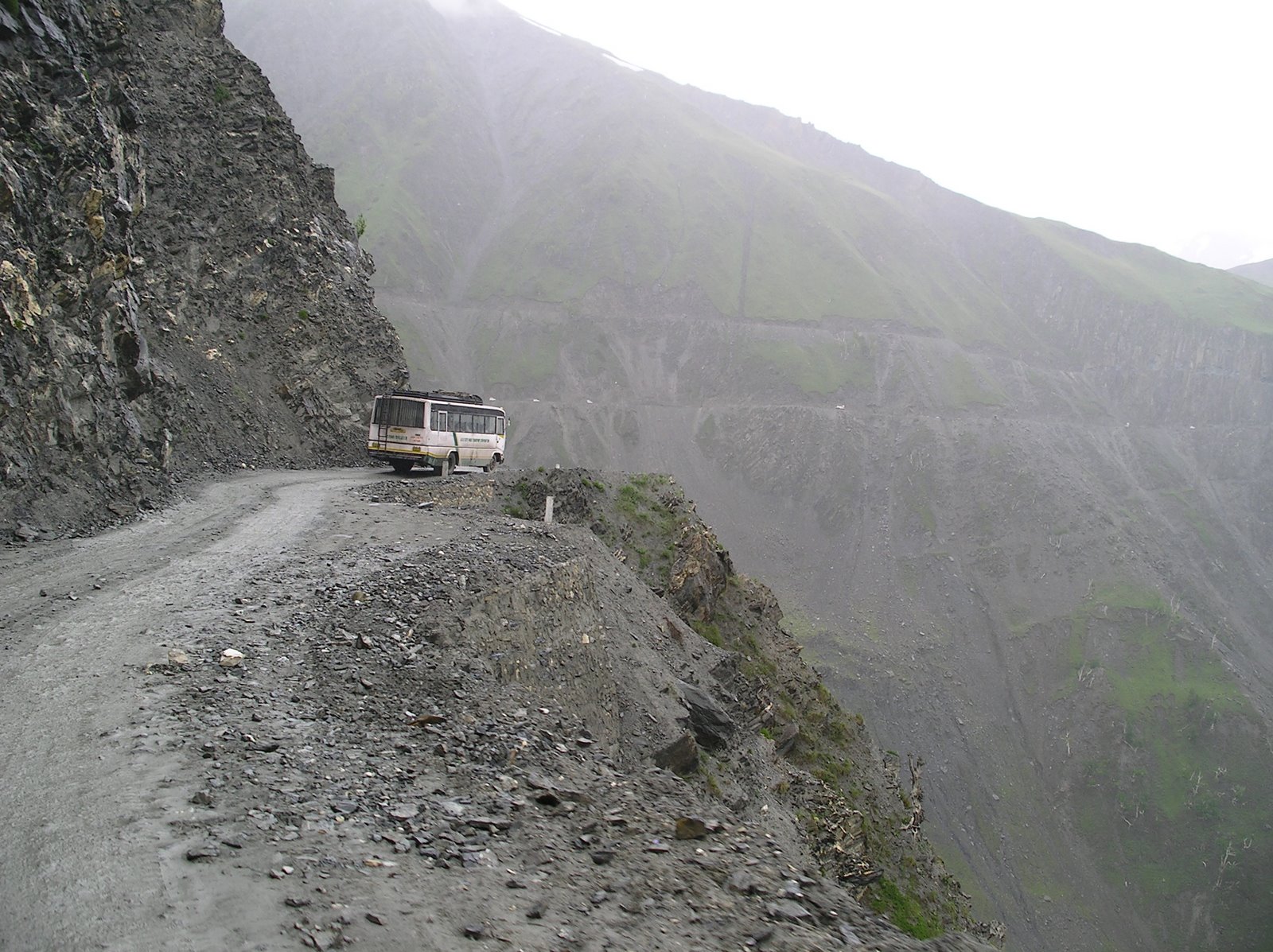
State Highways in ¬← NH 1C NH 2 → National Highway 1D (NH 1D), also known as Srinagar-Leh Highway, is a National Highway entirely within the state of Jammu & Kashmir in North India that connects Srinagar to Leh in Ladakh. It is one of the only two roads that connect Ladakh with the rest of India, the other being Leh-Manali Highway. The Srinagar-Leh Highway was declared as National Highway in 2006.[1][2]
The old Central Asian trade route Srinagar-Leh-Yarkand was also known as the Treaty Road, after a commercial treaty signed in 1870[3] between Maharaja Ranbir Singh and Thomas Douglas Forsyth.[4]
Contents
Weather conditions
Even nowadays, heavy snowfall at highest passes blocks traffic, cutting Leh from Ladakh for some six months each year. During springtime, the Border Roads Organisation (BRO) plows snow and repairs damages caused by landslides.[5] Zoji La pass received reportedly some 18 m (59 ft) of snowfall in 2008.[6]
Geography
For most part, NH 1D runs through extremely treacherous terrain and follows the historic trade route along the Indus River, thus giving modern travelers a glimpse of villages which are historically and culturally important[7]. The road generally remains open for traffic from early June to mid-November. The total length of NH 1D is 422 km (262 mi). [8]
The two highest passes on NH 1D include Fotu La at 4,108 m (13,478 ft) elevation and Zoji La at 3,528 m (11,575 ft) elevation.
Between Fotu La pass and Leh, a government checkpoint is stationed in the village of Khalatse.[9]
Dras, located some 170 km (110 mi) from Srinagar at elevation of 3,249 m (10,659 ft), is the first major village over the Zoji La pass. The village is inhabited by a population of mixed Kashmiri and Dard origins, having a reputation of being the second coldest permanent inhabited spot in the world after Siberia, with temperatures dropping to −45 °C (−49 °F).[9]
History
In the 17th and 18th centuries, the road was only a track, impassable even with ponies. Goods, mainly pashmina wool, were carried by porters from Yarkand and Tibet for Kashmir shawl industry.[4]
In 19th century, the route was improved, allowing pony caravans to pass.[9] This work was started after[4] Dogra General Zorawar Singh conquered Ladakh region from the Sikh Empire during 1836–1840 Trans-Himalayan campaign and princely state of Jammu and Kashmir was formed when the British sold Kashmir to maharaja Gulab Singh in 1846 Treaty of Amritsar.
In April 1873, the Kashmir government allocated 2,500 rupees annually for upkeep of the Treaty Road and associated serais.[4]
During the 1950s, tensions rose in Ladakh region. China had quietly been building a military road spanning some 1,200 km (750 mi) from Xinjiang to western Tibet. The road was discovered by Indians in 1957 and this was confirmed by Chinese maps showing the road in 1958. The political situation eroded, culminating in 1962 in the Sino-Indian War.
The road on the Chinese side gave PLA an advantage as a reliable supply line, giving the Indian Army impetus to build a road for supply and mobilisation of their own troops. The building started from Sringar in 1962, reaching Kargil in two years. This was the basis of modern Srinagar-Leh Highway. Building the road was hazardous task, given the challenging geographical location, and maintaining the road is still unenviable task.[6][9]
Restrictions on civilian traffic were lifted in 1974.[9]
This highway was used as mobilisation route by the Indian Army during Pakistani occupation of Kargil in 1999, known as Operation Vijay.
Gallery
References
- ^ Government of Jammu and Kashmir, Ladakh Autonomous Hill Development Council Kargil (April, 2006). "Monthly News Letter". http://kargil.nic.in/news/news.htm#Srinagar_Kargil-Leh_Road_Declares_as_National_Highway. Retrieved 2009-06-30.
- ^ ExpressIndia.com (April 23, 2006). "Srinagar-Leh road gets National Highway status". ExpressIndia.com. http://www.expressindia.com/news/fullstory.php?newsid=66549.
- ^ Jyoteeshwar Pathik (1997). Glimpses of History of Jammu & Kashmir. New Delhi, India: Anmol Publications. pp. 117. ISBN 81-7488-480-7. http://books.google.com/?id=OLvIvL5dcOQC&pg=PA117&lpg=PA117. Retrieved 2009-06-30.
- ^ a b c d Henry Osmaston (Editor), Philip Denwood (Editor) (1993). Recent Research on Ladakh 4 & 5: Proceedings of the Fourth and Fifth International Colloquia on Ladakh. Delhi, India: Motilal Banarsidass. pp. 236. ISBN 978-8120814042. http://books.google.com/?id=mCy2mBVNqSoC&pg=PA236&lpg=PA236. Retrieved 2009-06-30.
- ^ Thaindian.com (March 20, 2009). "Srinagar-Leh highway to reopen after remaining closed for six months". http://www.thaindian.com/newsportal/india-news/srinagar-leh-highway-to-reopen-after-remaining-closed-for-six-months_100169129.html. Retrieved 2009-06-30.
- ^ a b Thaindian.com (March 28, 2008). "Srinagar-Leh highway to reopen after remaining closed for six months". http://www.thaindian.com/newsportal/lifestyle/srinagar-leh-highway-to-be-opened-soon_10032210.html. Retrieved 2009-06-30.
- ^ [1] Ladakh, the Road journey
- ^ [2] Details of National Highways in India-Source-Govt. of India
- ^ a b c d e Hilary Keating (July/August 1993). [[3] "The Road to Leh"]. Saudi Aramco World (Houston, Texas: Aramco Services Company) 44 (4): 8–17. ISSN 1530-5821. [4]. Retrieved 2009-06-29.
External links
See also
- List of National Highways in India (by Highway Number)
- National Highways Development Project
- Origins of the Sino-Indian border dispute
- Sino-Indian War
Indian Highways Network National Expressways NE 1 • NE 2


State Expressways Mumbai-Pune • Delhi-Gurgaon • DND Flyway • Bengaluru-Mysore • Chennai HSCTC • Hyderabad Elevated ExpresswaysNational Highways 1 • 1A • 1B • 1C • 1D • 2 • 2A • 3 • 4 • 4A • 4B • 5 • 5A • 6 • 7 • 7A • 8 • 8A • 8B • 8C • 8D • 8E • 9 • 10 • 11 • 11A • 11B • 12 • 12A • 13 • 14 • 15 • 16 • 17 • 17A • 17B • 18 • 19 • 20 • 21 • 21A • 22 • 23 • 24 • 24A • 24B • 25 • 25A • 26 • 26A • 27 • 28 • 28A • 28B • 28C • 29 • 30 • 30A • 31 • 31A • 31B • 31C • 31D • 32 • 33 • 34 • 35 • 36 • 37 • 37A • 38 • 39 • 40 • 41 • 42 • 43 • 44 • 44A • 45 • 45A • 45B • 45C • 46 • 47 • 47A • 47B • 47C • 48 • 49 • 50 • 51 • 52 • 52A • 52B • 53 • 54 • 54A • 55 • 56 • 57 • 57A • 58 • 59 • 59A • 60 • 60A • 61 • 62 • 63 • 64 • 65 • 66 • 67 • 68 • 69 • 70 • 71 • 71A • 71B • 72 • 72A • 73 • 73A • 74 • 75 • 76 • 77 • 78 • 79 • 79A • 80 • 81 • 82 • 83 • 84 • 85 • 86 • 86A • 87 • 88 • 89 • 90 • 91 • 91A • 92 • 93 • 94 • 95 • 96 • 97 • 98 • 99 • 100 • 101 • 102 • 103 • 104 • 105 • 106 • 107 • 108 • 109 • 110 • 111 • 112 • 113 • 114 • 116 • 117 • 119 • 121 • 123 • 125 • 126 • 127 • 128 • 129 • 150 • 151 • 152 • 153 • 154 • 155 • 200 • 201 • 202 • 203 • 203A • 204 • 205 • 206 • 207 • 208 • 209 • 210 • 211 • 212 • 213 • 214 • 214A • 215 • 216 • 217 • 218 • 219 • 220 • 221 • 222 • 223 • 224 • 226 • 227 • 228 • 229 • 234 • 235State Highways Andhra Pradesh • Arunachal Pradesh • Assam • Bihar • Chhattisgarh • Goa • Gujarat • Haryana • Himachal Pradesh • Jammu and Kashmir • Jharkhand • Karnataka • Kerala • Madhya Pradesh • Maharashtra • Manipur • Meghalaya • Mizoram • Nagaland • Orissa • Punjab • Rajasthan • Sikkim • Tamil Nadu • Tripura • Uttarakhand • Uttar Pradesh • West BengalNotable Categories:- National Highways in Jammu and Kashmir
- Indian National Highways
-


Wikimedia Foundation. 2010.