- National Highway 68 (India)
-
National Highway 68

68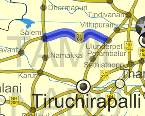
Road map of India with National Highway 68 highlighted in solid blue colorRoute information Length: 134 km (83 mi) Major junctions East end: Ulundurpettai, Tamil Nadu West end: Salem, Tamil Nadu Location States: Tamil Nadu Primary
destinations:Ulundrupet - Kallakkurichchi - Attur - Vazhapadi - Salem Highway system Indian Road Network
National • Expressways • State
State Highways in ¬← NH 67 NH 69 → National Highway 68 (NH 68) is a National Highway in India entirely within the state of Tamil Nadu. It runs between Ulundurpettai and Salem in the Indian state of Tamil Nadu for a total of 134 km (83 mi).[1] It connects with NH 7 and NH 47 at Salem. NH 68 connects NH 45 and SH 69 at Ulundurpettai.
Contents
Traffic
NH 68 is one of the under maintained road with lots of pot holes formed during the monsoon. The stretch between Thalaivasal and Attur used to smell due to discharges from Sago factories. This has been eliminated by economic development and enforcement.
This NH is currently planned to be upgraded to 4 Lane. Reliance Energy has won this project and have started the work. This includes 7 by pass roads in major town areas across the NH.[2]
NH 68 connects Salem, Coimbatore, Erode, Tirupur and the cities around these areas with Chennai.
Towns connected
Ulundurpettai, Elavanasur, Tiyagai Durgam, Kallakurichi, Chinnasalem, Thalaivasal, Kattukottai, Attur, Vazhapadi & Salem
See also
References
- ^ [1] Details of National Highways in India-Source-Govt. of India
- ^ [2] Salem to Ulunurpet road widening work-Source-National Highways Authority of India (NHAI)
Indian Highways Network National Expressways NE 1 • NE 2


State Expressways Mumbai-Pune • Delhi-Gurgaon • DND Flyway • Bengaluru-Mysore • Chennai HSCTC • Hyderabad Elevated ExpresswaysNational Highways 1 • 1A • 1B • 1C • 1D • 2 • 2A • 3 • 4 • 4A • 4B • 5 • 5A • 6 • 7 • 7A • 8 • 8A • 8B • 8C • 8D • 8E • 9 • 10 • 11 • 11A • 11B • 12 • 12A • 13 • 14 • 15 • 16 • 17 • 17A • 17B • 18 • 19 • 20 • 21 • 21A • 22 • 23 • 24 • 24A • 24B • 25 • 25A • 26 • 26A • 27 • 28 • 28A • 28B • 28C • 29 • 30 • 30A • 31 • 31A • 31B • 31C • 31D • 32 • 33 • 34 • 35 • 36 • 37 • 37A • 38 • 39 • 40 • 41 • 42 • 43 • 44 • 44A • 45 • 45A • 45B • 45C • 46 • 47 • 47A • 47B • 47C • 48 • 49 • 50 • 51 • 52 • 52A • 52B • 53 • 54 • 54A • 55 • 56 • 57 • 57A • 58 • 59 • 59A • 60 • 60A • 61 • 62 • 63 • 64 • 65 • 66 • 67 • 68 • 69 • 70 • 71 • 71A • 71B • 72 • 72A • 73 • 73A • 74 • 75 • 76 • 77 • 78 • 79 • 79A • 80 • 81 • 82 • 83 • 84 • 85 • 86 • 86A • 87 • 88 • 89 • 90 • 91 • 91A • 92 • 93 • 94 • 95 • 96 • 97 • 98 • 99 • 100 • 101 • 102 • 103 • 104 • 105 • 106 • 107 • 108 • 109 • 110 • 111 • 112 • 113 • 114 • 116 • 117 • 119 • 121 • 123 • 125 • 126 • 127 • 128 • 129 • 150 • 151 • 152 • 153 • 154 • 155 • 200 • 201 • 202 • 203 • 203A • 204 • 205 • 206 • 207 • 208 • 209 • 210 • 211 • 212 • 213 • 214 • 214A • 215 • 216 • 217 • 218 • 219 • 220 • 221 • 222 • 223 • 224 • 226 • 227 • 228 • 229 • 234 • 235State Highways Andhra Pradesh • Arunachal Pradesh • Assam • Bihar • Chhattisgarh • Goa • Gujarat • Haryana • Himachal Pradesh • Jammu and Kashmir • Jharkhand • Karnataka • Kerala • Madhya Pradesh • Maharashtra • Manipur • Meghalaya • Mizoram • Nagaland • Orissa • Punjab • Rajasthan • Sikkim • Tamil Nadu • Tripura • Uttarakhand • Uttar Pradesh • West BengalNotable Categories:- National Highways in Tamil Nadu
- Indian National Highways
- India road stubs


Wikimedia Foundation. 2010.