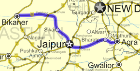
- National Highway 11 (India)
-
National Highway 11 
Route information Length: 582 km (362 mi) Major junctions From: Agra, Uttar Pradesh To: Bikaner, Rajasthan Location States: Uttar Pradesh: 51 km (32 mi)
Rajasthan: 531 km (330 mi)Primary
destinations:Agra -Bharatpur- Jaipur - Sikar - Bikaner Highway system Indian Road Network
National • Expressways • State← NH 10 NH 11A → National Highway 11 or NH 11 is a National Highway in India that links Agra in Uttar Pradesh with Bikaner in Rajasthan. This 582 km (362 mi)-long highway passes through Bharatpur, Dausa, Jaipur, Sikar and Fatehpur before terminating on National Highway 15 at Bikaner.
Of its total length, the National Highway 11 traverses 51 km (32 mi) in Uttar Pradesh and the rest 531 km (330 mi) in Rajasthan. NH 11 is an important tourism highway because it connects two of the most popular tourist destination of India i.e Agra and Jaipur.The world famous Keoladeo National Park of Bharatpur also lies on this highway which is also a UNESCO's world heritage site.
Road Construction
Serial No Chainage Length (in km) NHDP Phase Category Concessionaire Funded By State 1 Reengus - Sikar 43.887 NHDP Phase III G.R.Infraprojects Annuity Rajasthan See also
- List of National Highways in India (by Highway Number)
- National Highways Development Project
External links
 Media related to NH 11 (India) at Wikimedia Commons
- [1] Map of NH 11
Indian Highways Network National Expressways NE 1 • NE 2

State Expressways Mumbai-Pune • Delhi-Gurgaon • DND Flyway • Bengaluru-Mysore • Chennai HSCTC • Hyderabad Elevated ExpresswaysNational Highways 1 • 1A • 1B • 1C • 1D • 2 • 2A • 3 • 4 • 4A • 4B • 5 • 5A • 6 • 7 • 7A • 8 • 8A • 8B • 8C • 8D • 8E • 9 • 10 • 11 • 11A • 11B • 12 • 12A • 13 • 14 • 15 • 16 • 17 • 17A • 17B • 18 • 19 • 20 • 21 • 21A • 22 • 23 • 24 • 24A • 24B • 25 • 25A • 26 • 26A • 27 • 28 • 28A • 28B • 28C • 29 • 30 • 30A • 31 • 31A • 31B • 31C • 31D • 32 • 33 • 34 • 35 • 36 • 37 • 37A • 38 • 39 • 40 • 41 • 42 • 43 • 44 • 44A • 45 • 45A • 45B • 45C • 46 • 47 • 47A • 47B • 47C • 48 • 49 • 50 • 51 • 52 • 52A • 52B • 53 • 54 • 54A • 55 • 56 • 57 • 57A • 58 • 59 • 59A • 60 • 60A • 61 • 62 • 63 • 64 • 65 • 66 • 67 • 68 • 69 • 70 • 71 • 71A • 71B • 72 • 72A • 73 • 73A • 74 • 75 • 76 • 77 • 78 • 79 • 79A • 80 • 81 • 82 • 83 • 84 • 85 • 86 • 86A • 87 • 88 • 89 • 90 • 91 • 91A • 92 • 93 • 94 • 95 • 96 • 97 • 98 • 99 • 100 • 101 • 102 • 103 • 104 • 105 • 106 • 107 • 108 • 109 • 110 • 111 • 112 • 113 • 114 • 116 • 117 • 119 • 121 • 123 • 125 • 126 • 127 • 128 • 129 • 150 • 151 • 152 • 153 • 154 • 155 • 200 • 201 • 202 • 203 • 203A • 204 • 205 • 206 • 207 • 208 • 209 • 210 • 211 • 212 • 213 • 214 • 214A • 215 • 216 • 217 • 218 • 219 • 220 • 221 • 222 • 223 • 224 • 226 • 227 • 228 • 229 • 234 • 235State Highways Andhra Pradesh • Arunachal Pradesh • Assam • Bihar • Chhattisgarh • Goa • Gujarat • Haryana • Himachal Pradesh • Jammu and Kashmir • Jharkhand • Karnataka • Kerala • Madhya Pradesh • Maharashtra • Manipur • Meghalaya • Mizoram • Nagaland • Orissa • Punjab • Rajasthan • Sikkim • Tamil Nadu • Tripura • Uttarakhand • Uttar Pradesh • West BengalNotable Categories:- National Highways in Uttar Pradesh
- National Highways in Rajasthan
- Indian National Highways
- India road stubs
Wikimedia Foundation. 2010.


