- National Highway 56 (India)
-
National Highway 56

56
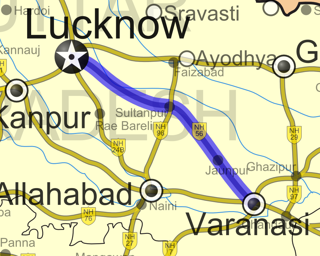
Road map of India with National Highway 56 highlighted in solid blue colorRoute information Length: 285 km (177 mi) Major junctions Northwest end: Lucknow, Uttar Pradesh Southeast end: Varanasi, Uttar Pradesh Location States: Uttar Pradesh Primary
destinations:Lucknow - Sultanpur - Jaunpur - Varanasi Highway system Indian Road Network
National • Expressways • State
State Highways in ¬← NH 55 NH 57 → National Highway 56 (NH 56) is a National Highway in Northern India entirely within the state of Uttar Pradesh. NH 56 links State Capital Lucknow with Varanasi. The total length of NH 56 is 285 km (177 mi).[1]
Starting from Mahatma Gandhi Marg in Lucknow, NH 56 ends at Sarnath road at Varanasi. The road is called Jaunpur road and Kautilya Kon road as it approaches Varanasi.
Route
Lucknow, Gosaiganj, Amethi, Haldagarh, Inhauna, Sultanpur, Lambhua, Chanda, Badlapur, Jaunpur, Phulpur and Varanasi.[2]
References
- ^ [1] Details of National Highways in India-Source-Government of India
- ^ Google Maps Route Map on Google Maps
External Links
- [2] Driving Directions for NH56, Map of National Highway 56-Source-MapsofIndia.com
Indian Highways Network National Expressways NE 1 • NE 2


State Expressways Mumbai-Pune • Delhi-Gurgaon • DND Flyway • Bengaluru-Mysore • Chennai HSCTC • Hyderabad Elevated ExpresswaysNational Highways 1 • 1A • 1B • 1C • 1D • 2 • 2A • 3 • 4 • 4A • 4B • 5 • 5A • 6 • 7 • 7A • 8 • 8A • 8B • 8C • 8D • 8E • 9 • 10 • 11 • 11A • 11B • 12 • 12A • 13 • 14 • 15 • 16 • 17 • 17A • 17B • 18 • 19 • 20 • 21 • 21A • 22 • 23 • 24 • 24A • 24B • 25 • 25A • 26 • 26A • 27 • 28 • 28A • 28B • 28C • 29 • 30 • 30A • 31 • 31A • 31B • 31C • 31D • 32 • 33 • 34 • 35 • 36 • 37 • 37A • 38 • 39 • 40 • 41 • 42 • 43 • 44 • 44A • 45 • 45A • 45B • 45C • 46 • 47 • 47A • 47B • 47C • 48 • 49 • 50 • 51 • 52 • 52A • 52B • 53 • 54 • 54A • 55 • 56 • 57 • 57A • 58 • 59 • 59A • 60 • 60A • 61 • 62 • 63 • 64 • 65 • 66 • 67 • 68 • 69 • 70 • 71 • 71A • 71B • 72 • 72A • 73 • 73A • 74 • 75 • 76 • 77 • 78 • 79 • 79A • 80 • 81 • 82 • 83 • 84 • 85 • 86 • 86A • 87 • 88 • 89 • 90 • 91 • 91A • 92 • 93 • 94 • 95 • 96 • 97 • 98 • 99 • 100 • 101 • 102 • 103 • 104 • 105 • 106 • 107 • 108 • 109 • 110 • 111 • 112 • 113 • 114 • 116 • 117 • 119 • 121 • 123 • 125 • 126 • 127 • 128 • 129 • 150 • 151 • 152 • 153 • 154 • 155 • 200 • 201 • 202 • 203 • 203A • 204 • 205 • 206 • 207 • 208 • 209 • 210 • 211 • 212 • 213 • 214 • 214A • 215 • 216 • 217 • 218 • 219 • 220 • 221 • 222 • 223 • 224 • 226 • 227 • 228 • 229 • 234 • 235State Highways Andhra Pradesh • Arunachal Pradesh • Assam • Bihar • Chhattisgarh • Goa • Gujarat • Haryana • Himachal Pradesh • Jammu and Kashmir • Jharkhand • Karnataka • Kerala • Madhya Pradesh • Maharashtra • Manipur • Meghalaya • Mizoram • Nagaland • Orissa • Punjab • Rajasthan • Sikkim • Tamil Nadu • Tripura • Uttarakhand • Uttar Pradesh • West BengalNotable Categories:- National Highways in Uttar Pradesh
- Indian National Highways
- India road stubs


Wikimedia Foundation. 2010.