- National Highway 63 (India)
-
National Highway 63

63राष्ट्रीय राजमार्ग ६३/ ರಾಷ್ಟ್ರೀಯ ಹೆದ್ದಾರಿ ೬೩ 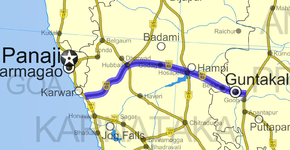
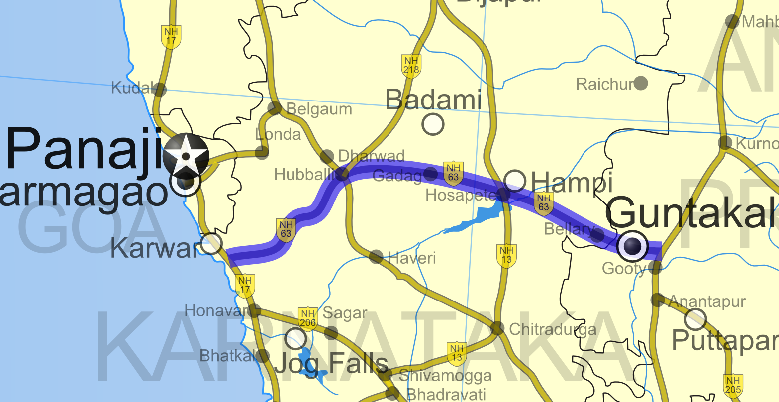
Road map of India with National Highway 63 highlighted in solid blue colorRoute information Length: 432 km (268 mi) Major junctions West end: Ankola, Karnataka NH 17 in Ankola
NH 7 in Gooty
NH 4 in Hubballi
NH 218 in Hubballi
NH 13 in HosapeteEast end: Gooty, Andhra Pradesh Location States: Karnataka: 370 km (230 mi)
Andhra Pradesh: 62 km (39 mi)Primary
destinations:Ankola - Yellapur - Hubballi - Gadag - Koppal - Hosapete - Toranagallu - Bellary - Gooty Highway system Indian Road Network
National • Expressways • State
State Highways in ¬← NH 62 NH 64 → National Highway 63 ( NH-63 ) (Hindi: राष्ट्रीय राजमार्ग ६३ Kannada: ರಾಷ್ಟ್ರೀಯ ಹೆದ್ದಾರಿ ೬೩) is a National highway within the two southern states of Karnataka and Andhra Pradesh in India. It connects Ankola on NH 17 in Karnataka to Gooty NH 7 on in Andhra Pradesh. This highway was previously a state highway. The Total length of NH 63 runs to 432 km (268 mi). [1]
NH-63 passes through Yellapura, Hubli, Gadag, Koppal, Hosapete, Toranagallu, Bellary and Guntakal and usually traveses east-west. This highway is heavily used by trucks carrying ores of iron and manganese to New Mangalore Port and Karwar port from mining areas of Bellary district and other parts of northern Karnataka.
See also
- List of National Highways in India (by Highway Number)
- National Highways Development Project
References
- ^ "National Highways and their lengths". Ministry of Road Transport & Highways, Government of India. National Highways Authority of India. http://www.nhai.org/nh.asp. Retrieved 2009-02-12.
External links
- [1] NH-63 map
Indian Highways Network National Expressways NE 1 • NE 2


State Expressways Mumbai-Pune • Delhi-Gurgaon • DND Flyway • Bengaluru-Mysore • Chennai HSCTC • Hyderabad Elevated ExpresswaysNational Highways 1 • 1A • 1B • 1C • 1D • 2 • 2A • 3 • 4 • 4A • 4B • 5 • 5A • 6 • 7 • 7A • 8 • 8A • 8B • 8C • 8D • 8E • 9 • 10 • 11 • 11A • 11B • 12 • 12A • 13 • 14 • 15 • 16 • 17 • 17A • 17B • 18 • 19 • 20 • 21 • 21A • 22 • 23 • 24 • 24A • 24B • 25 • 25A • 26 • 26A • 27 • 28 • 28A • 28B • 28C • 29 • 30 • 30A • 31 • 31A • 31B • 31C • 31D • 32 • 33 • 34 • 35 • 36 • 37 • 37A • 38 • 39 • 40 • 41 • 42 • 43 • 44 • 44A • 45 • 45A • 45B • 45C • 46 • 47 • 47A • 47B • 47C • 48 • 49 • 50 • 51 • 52 • 52A • 52B • 53 • 54 • 54A • 55 • 56 • 57 • 57A • 58 • 59 • 59A • 60 • 60A • 61 • 62 • 63 • 64 • 65 • 66 • 67 • 68 • 69 • 70 • 71 • 71A • 71B • 72 • 72A • 73 • 73A • 74 • 75 • 76 • 77 • 78 • 79 • 79A • 80 • 81 • 82 • 83 • 84 • 85 • 86 • 86A • 87 • 88 • 89 • 90 • 91 • 91A • 92 • 93 • 94 • 95 • 96 • 97 • 98 • 99 • 100 • 101 • 102 • 103 • 104 • 105 • 106 • 107 • 108 • 109 • 110 • 111 • 112 • 113 • 114 • 116 • 117 • 119 • 121 • 123 • 125 • 126 • 127 • 128 • 129 • 150 • 151 • 152 • 153 • 154 • 155 • 200 • 201 • 202 • 203 • 203A • 204 • 205 • 206 • 207 • 208 • 209 • 210 • 211 • 212 • 213 • 214 • 214A • 215 • 216 • 217 • 218 • 219 • 220 • 221 • 222 • 223 • 224 • 226 • 227 • 228 • 229 • 234 • 235State Highways Andhra Pradesh • Arunachal Pradesh • Assam • Bihar • Chhattisgarh • Goa • Gujarat • Haryana • Himachal Pradesh • Jammu and Kashmir • Jharkhand • Karnataka • Kerala • Madhya Pradesh • Maharashtra • Manipur • Meghalaya • Mizoram • Nagaland • Orissa • Punjab • Rajasthan • Sikkim • Tamil Nadu • Tripura • Uttarakhand • Uttar Pradesh • West BengalNotable Categories:- National Highways in Karnataka
- National Highways in Andhra Pradesh
- Indian National Highways
- India road stubs


Wikimedia Foundation. 2010.