- National Highway 62 (India)
-
National Highway 62

62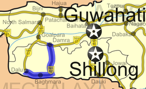
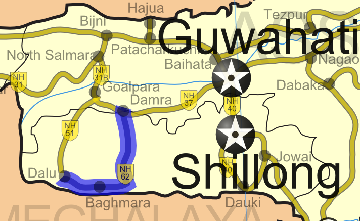
Road map of India with National Highway 62 highlighted in blueRoute information Length: 195 km (121 mi) Major junctions From: Damra, Assam To: Dalu, Meghalaya Location States: Assam: 5 km (3.1 mi)
Meghalaya: 190 km (120 mi)Primary
destinations:Baghmara Highway system Indian Road Network
National • Expressways • State
State Highways in ¬← NH 61 NH 63 → National Highway 62 (NH 62) is a National Highway in Northeast India. It starts from Damra in Assam and ends at Dalu, in Meghalaya. The highway is 195 km (121 mi) long, of which 5 km (3.1 mi) is in Assam and 190 is in Meghalaya. [1]
Contents
Concerned Issues
NH 62 is the route which many coal traders use to bring coals from the minefields of nangal, dubu located in Meghalaya. These trucks are always overloaded and they carry 35 to 40 Tons of coal while the set limit by the government is only 15 tons, and the local administration is helping the truck owners and coal merchants by taking a sum of Rs 300 only without imposing any fines for overloading which otherwise would have been around Rs 20000 per truck, and averagely 300 coal loaded trucks uses NH 62 everyday. Moreover the NHAI has not taken any measures to end this overloading of trucks and the corrupt police officers which also includes the high ranked personnel are eating the money which otherwise would have gone to the government treasury.[citation needed]
NH 62 is a highly commercial route and setting up a Toll Plaza is very important both to stop this illegal overloading, Maintenance of the highway. And it will also help in killing the other problems caused by overloading such as high emission of pollution by the overloaded trucks. And looking at the current environmental issues the government should take serious steps in regulating the trucks transporting coals.[citation needed]
Route
See also
- List of National Highways in India (by Highway Number)
- List of National Highways in India
- National Highways Development Project
References
External links
- [2] NH network map of India
Indian Highways Network National Expressways NE 1 • NE 2


State Expressways Mumbai-Pune • Delhi-Gurgaon • DND Flyway • Bengaluru-Mysore • Chennai HSCTC • Hyderabad Elevated ExpresswaysNational Highways 1 • 1A • 1B • 1C • 1D • 2 • 2A • 3 • 4 • 4A • 4B • 5 • 5A • 6 • 7 • 7A • 8 • 8A • 8B • 8C • 8D • 8E • 9 • 10 • 11 • 11A • 11B • 12 • 12A • 13 • 14 • 15 • 16 • 17 • 17A • 17B • 18 • 19 • 20 • 21 • 21A • 22 • 23 • 24 • 24A • 24B • 25 • 25A • 26 • 26A • 27 • 28 • 28A • 28B • 28C • 29 • 30 • 30A • 31 • 31A • 31B • 31C • 31D • 32 • 33 • 34 • 35 • 36 • 37 • 37A • 38 • 39 • 40 • 41 • 42 • 43 • 44 • 44A • 45 • 45A • 45B • 45C • 46 • 47 • 47A • 47B • 47C • 48 • 49 • 50 • 51 • 52 • 52A • 52B • 53 • 54 • 54A • 55 • 56 • 57 • 57A • 58 • 59 • 59A • 60 • 60A • 61 • 62 • 63 • 64 • 65 • 66 • 67 • 68 • 69 • 70 • 71 • 71A • 71B • 72 • 72A • 73 • 73A • 74 • 75 • 76 • 77 • 78 • 79 • 79A • 80 • 81 • 82 • 83 • 84 • 85 • 86 • 86A • 87 • 88 • 89 • 90 • 91 • 91A • 92 • 93 • 94 • 95 • 96 • 97 • 98 • 99 • 100 • 101 • 102 • 103 • 104 • 105 • 106 • 107 • 108 • 109 • 110 • 111 • 112 • 113 • 114 • 116 • 117 • 119 • 121 • 123 • 125 • 126 • 127 • 128 • 129 • 150 • 151 • 152 • 153 • 154 • 155 • 200 • 201 • 202 • 203 • 203A • 204 • 205 • 206 • 207 • 208 • 209 • 210 • 211 • 212 • 213 • 214 • 214A • 215 • 216 • 217 • 218 • 219 • 220 • 221 • 222 • 223 • 224 • 226 • 227 • 228 • 229 • 234 • 235State Highways Andhra Pradesh • Arunachal Pradesh • Assam • Bihar • Chhattisgarh • Goa • Gujarat • Haryana • Himachal Pradesh • Jammu and Kashmir • Jharkhand • Karnataka • Kerala • Madhya Pradesh • Maharashtra • Manipur • Meghalaya • Mizoram • Nagaland • Orissa • Punjab • Rajasthan • Sikkim • Tamil Nadu • Tripura • Uttarakhand • Uttar Pradesh • West BengalNotable Categories:- National Highways in Assam
- National Highways in Meghalaya
- Indian National Highways
- India road stubs


Wikimedia Foundation. 2010.