- National Highway 202 (India)
-
National Highway 202 
Route information Length: 280 km (170 mi) Major junctions From: Hyderabad, Andhra Pradesh National Highway 7 in Hyderabad
National Highway 9 in Hyderabad
National Highway 16 at BhopalpatnamTo: Bhopalpatnam, Chhattisgarh Location States: Andhra Pradesh: 244 km
Chhattisgarh: 36 kmPrimary
destinations:Warangal - Venkatapuram Highway system Indian Road Network
National • Expressways • State
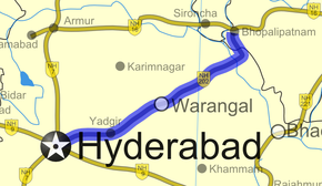
State Highways in ¬← NH 201 NH 203 → National Highway 202 (NH 202) is a National Highway in India that links Hyderabad in Andhra Pradesh and Bhopalpatnam in Chattisgarh. The road till Warangal was already a state highway. It was extended and upgraded to a NH as the shortest route to connect Chattisgarh to an important city.
Route
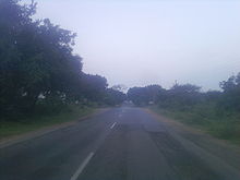
 National Highway 202 (India) on the outskirts of Uppal Kalan
- In Hyderabad city, the highway passes through Golnaka, Amberpet, Ramanthapur and Uppal Kalan areas along the northern banks of River Musi.
- The highway passes through Ghatkesar, Bhongir, Aleru, Jangaon, Raghunathpalle, Station Ghanpur, Warangal, Atmakur, Mallampalli, Mulug, Eturu Nagaram, Chandrupatla and Bhadrakali.[1]
- It is arbitrarily calculated about 280 kilometers, in which the stretch in Andhra Pradesh is about 244 kilometers and in Chattisgarh 36 kilometers.
- The highway joins National Highway 16 (India) at Bhopalpatnam, but there is no bridge across River Godavari at Nagaram village so travellers have to go all the way to Bhadrachalam to get into chattisgarh.
- The highway joins National Highway 7 (India) at Hyderabad.
References
Indian Highways Network National Expressways NE 1 • NE 2

State Expressways Mumbai-Pune • Delhi-Gurgaon • DND Flyway • Bengaluru-Mysore • Chennai HSCTC • Hyderabad Elevated ExpresswaysNational Highways 1 • 1A • 1B • 1C • 1D • 2 • 2A • 3 • 4 • 4A • 4B • 5 • 5A • 6 • 7 • 7A • 8 • 8A • 8B • 8C • 8D • 8E • 9 • 10 • 11 • 11A • 11B • 12 • 12A • 13 • 14 • 15 • 16 • 17 • 17A • 17B • 18 • 19 • 20 • 21 • 21A • 22 • 23 • 24 • 24A • 24B • 25 • 25A • 26 • 26A • 27 • 28 • 28A • 28B • 28C • 29 • 30 • 30A • 31 • 31A • 31B • 31C • 31D • 32 • 33 • 34 • 35 • 36 • 37 • 37A • 38 • 39 • 40 • 41 • 42 • 43 • 44 • 44A • 45 • 45A • 45B • 45C • 46 • 47 • 47A • 47B • 47C • 48 • 49 • 50 • 51 • 52 • 52A • 52B • 53 • 54 • 54A • 55 • 56 • 57 • 57A • 58 • 59 • 59A • 60 • 60A • 61 • 62 • 63 • 64 • 65 • 66 • 67 • 68 • 69 • 70 • 71 • 71A • 71B • 72 • 72A • 73 • 73A • 74 • 75 • 76 • 77 • 78 • 79 • 79A • 80 • 81 • 82 • 83 • 84 • 85 • 86 • 86A • 87 • 88 • 89 • 90 • 91 • 91A • 92 • 93 • 94 • 95 • 96 • 97 • 98 • 99 • 100 • 101 • 102 • 103 • 104 • 105 • 106 • 107 • 108 • 109 • 110 • 111 • 112 • 113 • 114 • 116 • 117 • 119 • 121 • 123 • 125 • 126 • 127 • 128 • 129 • 150 • 151 • 152 • 153 • 154 • 155 • 200 • 201 • 202 • 203 • 203A • 204 • 205 • 206 • 207 • 208 • 209 • 210 • 211 • 212 • 213 • 214 • 214A • 215 • 216 • 217 • 218 • 219 • 220 • 221 • 222 • 223 • 224 • 226 • 227 • 228 • 229 • 234 • 235State Highways Andhra Pradesh • Arunachal Pradesh • Assam • Bihar • Chhattisgarh • Goa • Gujarat • Haryana • Himachal Pradesh • Jammu and Kashmir • Jharkhand • Karnataka • Kerala • Madhya Pradesh • Maharashtra • Manipur • Meghalaya • Mizoram • Nagaland • Orissa • Punjab • Rajasthan • Sikkim • Tamil Nadu • Tripura • Uttarakhand • Uttar Pradesh • West BengalNotable Categories:- National Highways in Andhra Pradesh
- National Highways in Chhattisgarh
- Indian National Highways
- India road stubs
Wikimedia Foundation. 2010.


