- National Highway 13 (India)
-
National Highway 13

13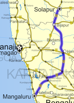
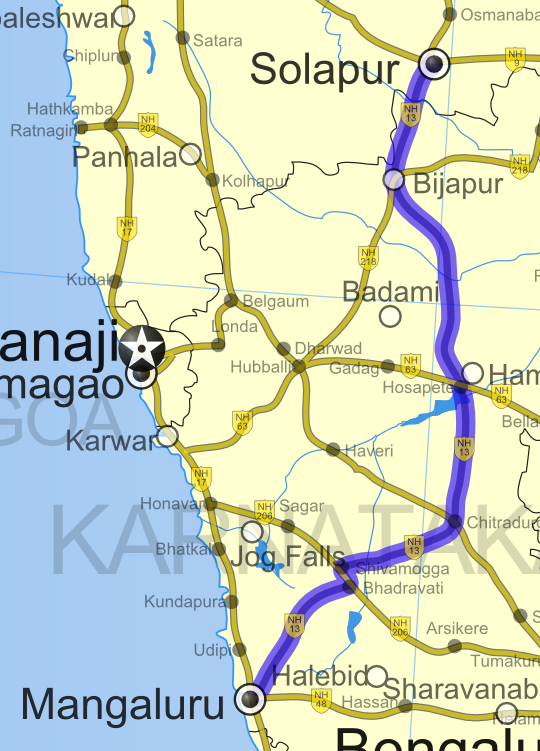
Route information Length: 691 km (429 mi) Major junctions From: Solapur, Maharashtra NH 9 in Solapur
NH 48 in Mangalore
NH 211 in Solapur
NH 63 in Hospet
NH 4 in Chitradurga
NH 206 in Shimoga
NH 17 in MangaloreTo: Mangalore, Karnataka Location States: Maharashtra: 43 km (27 mi)
Karnataka: 648 km (403 mi)Primary
destinations:Solapur - Bijapur - Chitradurga - Mangalore Highway system Indian Road Network
National • Expressways • State← NH 12A NH 14 → National Highway 13 ('NH 13), now renamed as NH 169[1] is a National Highway in India that runs from Solapur in Maharashtra to Mangalore in Karnataka. The total length of NH 13 is 691 km (429 mi). The original NH 13 ran from Solapur to Chitradurga at the intersection of NH 4. It has recently been extended to Mangalore. [2]
NH 13 passes through towns of Bijapur, Basavana Bagewadi, Hosapete and Shivamogga. It passes through all geographical regions of Karnataka state namely Bayaluseemae, Malenadu and Karavali.
Though road is marked as a national highway, it is narrow along many stretches causing frequent mishaps.In particular, the stretch between Chitradurga and Hospet is extremely bad and with heavy truck traffic. Driving this stretch in a car, particularly in the nights, is not advisable due to the bad condition of the road.
See also
- List of National Highways in India (by Highway Number)
- National Highways Development Project
References
- ^ http://www.bellevision.com/index.php?action=topnews&type=1853
- ^ [1] Details of National Highways in India-Source-Govt. of India
External links
- [2] NH 13 Map]
Indian Highways Network National Expressways NE 1 • NE 2


State Expressways Mumbai-Pune • Delhi-Gurgaon • DND Flyway • Bengaluru-Mysore • Chennai HSCTC • Hyderabad Elevated ExpresswaysNational Highways 1 • 1A • 1B • 1C • 1D • 2 • 2A • 3 • 4 • 4A • 4B • 5 • 5A • 6 • 7 • 7A • 8 • 8A • 8B • 8C • 8D • 8E • 9 • 10 • 11 • 11A • 11B • 12 • 12A • 13 • 14 • 15 • 16 • 17 • 17A • 17B • 18 • 19 • 20 • 21 • 21A • 22 • 23 • 24 • 24A • 24B • 25 • 25A • 26 • 26A • 27 • 28 • 28A • 28B • 28C • 29 • 30 • 30A • 31 • 31A • 31B • 31C • 31D • 32 • 33 • 34 • 35 • 36 • 37 • 37A • 38 • 39 • 40 • 41 • 42 • 43 • 44 • 44A • 45 • 45A • 45B • 45C • 46 • 47 • 47A • 47B • 47C • 48 • 49 • 50 • 51 • 52 • 52A • 52B • 53 • 54 • 54A • 55 • 56 • 57 • 57A • 58 • 59 • 59A • 60 • 60A • 61 • 62 • 63 • 64 • 65 • 66 • 67 • 68 • 69 • 70 • 71 • 71A • 71B • 72 • 72A • 73 • 73A • 74 • 75 • 76 • 77 • 78 • 79 • 79A • 80 • 81 • 82 • 83 • 84 • 85 • 86 • 86A • 87 • 88 • 89 • 90 • 91 • 91A • 92 • 93 • 94 • 95 • 96 • 97 • 98 • 99 • 100 • 101 • 102 • 103 • 104 • 105 • 106 • 107 • 108 • 109 • 110 • 111 • 112 • 113 • 114 • 116 • 117 • 119 • 121 • 123 • 125 • 126 • 127 • 128 • 129 • 150 • 151 • 152 • 153 • 154 • 155 • 200 • 201 • 202 • 203 • 203A • 204 • 205 • 206 • 207 • 208 • 209 • 210 • 211 • 212 • 213 • 214 • 214A • 215 • 216 • 217 • 218 • 219 • 220 • 221 • 222 • 223 • 224 • 226 • 227 • 228 • 229 • 234 • 235State Highways Andhra Pradesh • Arunachal Pradesh • Assam • Bihar • Chhattisgarh • Goa • Gujarat • Haryana • Himachal Pradesh • Jammu and Kashmir • Jharkhand • Karnataka • Kerala • Madhya Pradesh • Maharashtra • Manipur • Meghalaya • Mizoram • Nagaland • Orissa • Punjab • Rajasthan • Sikkim • Tamil Nadu • Tripura • Uttarakhand • Uttar Pradesh • West BengalNotable Categories:- National Highways in Maharashtra
- National Highways in Karnataka
- Transport in Mangalore
- Indian National Highways
- India road stubs


Wikimedia Foundation. 2010.