- National Highway 16 (India)
-
National Highway 16

16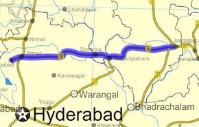
Route information Length: 179 km (111 mi) Major junctions From: Nizamabad, Andhra Pradesh To: Jagdalpur, Chhattisgarh Location States: Andhra Pradesh: 220 km
Maharashtra: 30 km
Chhattisgarh: 210 kmPrimary
destinations:Armur - Metpalli - Yelgonda - Jaipuram - Chinnoor - Sironcha - Pathagudam - Bhopalpatnam - Bijapur - Bhairamgarh - Gidam - Bagmundi - Jagdalpur Highway system Indian Road Network
National • Expressways • State
State Highways in ¬← NH 15 NH 17 → National Highway 16 or NH 16 a National Highway in India, total length 460 km (290 mi) that connects Nizamabad in Andhra Pradesh and Jagdalpur in Chhattisgarh. It passes through the states of Andhra Pradesh, Maharashtra and Chhattisgarh.[1]
Route
- The highway passes through
- The highway crosses National Highway 7 at Armoor.
- National Highway 202 joins this highway at Bhopalpatnam.
The highway crosses Pranahita River on border of Maharashtra and Andhra Pradesh and Indravati River on border of Maharashtra and Chhattisgarh.
Additional Traveler Information
NH 16 currently has a missing link. The Pranahita River has not been bridged across at Sironcha. So at present NH 16 breaks on the Andhra Pradesh side of Pranahita. There is a ferry service but it does not carry cars and other vehicles. The highway passes through dense forests and the most of the course of the highway is through the naxalites affected areas.
References
- ^ [1] Details of National Highways in India-Source-Govt. of India
- ^ Maps of India.NH16
Indian Highways Network National Expressways NE 1 • NE 2


State Expressways Mumbai-Pune • Delhi-Gurgaon • DND Flyway • Bengaluru-Mysore • Chennai HSCTC • Hyderabad Elevated ExpresswaysNational Highways 1 • 1A • 1B • 1C • 1D • 2 • 2A • 3 • 4 • 4A • 4B • 5 • 5A • 6 • 7 • 7A • 8 • 8A • 8B • 8C • 8D • 8E • 9 • 10 • 11 • 11A • 11B • 12 • 12A • 13 • 14 • 15 • 16 • 17 • 17A • 17B • 18 • 19 • 20 • 21 • 21A • 22 • 23 • 24 • 24A • 24B • 25 • 25A • 26 • 26A • 27 • 28 • 28A • 28B • 28C • 29 • 30 • 30A • 31 • 31A • 31B • 31C • 31D • 32 • 33 • 34 • 35 • 36 • 37 • 37A • 38 • 39 • 40 • 41 • 42 • 43 • 44 • 44A • 45 • 45A • 45B • 45C • 46 • 47 • 47A • 47B • 47C • 48 • 49 • 50 • 51 • 52 • 52A • 52B • 53 • 54 • 54A • 55 • 56 • 57 • 57A • 58 • 59 • 59A • 60 • 60A • 61 • 62 • 63 • 64 • 65 • 66 • 67 • 68 • 69 • 70 • 71 • 71A • 71B • 72 • 72A • 73 • 73A • 74 • 75 • 76 • 77 • 78 • 79 • 79A • 80 • 81 • 82 • 83 • 84 • 85 • 86 • 86A • 87 • 88 • 89 • 90 • 91 • 91A • 92 • 93 • 94 • 95 • 96 • 97 • 98 • 99 • 100 • 101 • 102 • 103 • 104 • 105 • 106 • 107 • 108 • 109 • 110 • 111 • 112 • 113 • 114 • 116 • 117 • 119 • 121 • 123 • 125 • 126 • 127 • 128 • 129 • 150 • 151 • 152 • 153 • 154 • 155 • 200 • 201 • 202 • 203 • 203A • 204 • 205 • 206 • 207 • 208 • 209 • 210 • 211 • 212 • 213 • 214 • 214A • 215 • 216 • 217 • 218 • 219 • 220 • 221 • 222 • 223 • 224 • 226 • 227 • 228 • 229 • 234 • 235State Highways Andhra Pradesh • Arunachal Pradesh • Assam • Bihar • Chhattisgarh • Goa • Gujarat • Haryana • Himachal Pradesh • Jammu and Kashmir • Jharkhand • Karnataka • Kerala • Madhya Pradesh • Maharashtra • Manipur • Meghalaya • Mizoram • Nagaland • Orissa • Punjab • Rajasthan • Sikkim • Tamil Nadu • Tripura • Uttarakhand • Uttar Pradesh • West BengalNotable Categories:- National Highways in Andhra Pradesh
- National Highways in Maharashtra
- National Highways in Chhattisgarh
- Indian National Highways


Wikimedia Foundation. 2010.