- National Highway 47 (India)
-
National Highway 47

47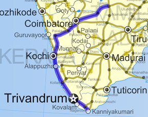
Road map of India with National Highway 47 highlighted in solid blue colorRoute information Length: 640 km (400 mi) Major junctions North end: Salem, Tamil Nadu Coimbatore (NH 67),
Edapally (NH 17),
Kundannoor (NH 49)South end: Kanyakumari, Tamil Nadu Location States: Kerala: 416 km (258 mi)
Tamil Nadu: 224 km (139 mi)Primary
destinations:Salem - Coimbatore - Palakkad - Thrissur - Kochi - Thiruvananthapuram - Nagercoil - Kanyakumari Highway system Indian Road Network
National • Expressways • State
State Highways in ¬← NH 46 NH 47A → National Highway 47, commonly referred to as NH 47, is a 650 km (400 mi) long highway connecting the city of Salem to Kanyakumari town in southern India. The highway runs through the states of Kerala and Tamil Nadu,[1] connecting various important cities and towns such as Salem, Coimbatore, Palakkad, Thrissur, Kochi, Alappuzha, Kollam, Thiruvananthapuram, Nagercoil and Kanyakumari.[2]
The NH 47 runs within a few kilometers of , Coimbatore International Airport (within Coimbatore city limits), Cochin International Airport (Nedumbassery) and the Thiruvananthapuram (Trivandrum) International Airport.
The Salem-Coimbatore-Kochi stretch of the highway is included in the North-South Corridor of the Indian highway system. It is currently undergoing conversion to 4 lane, with some sections 6 lane.[3][4] At the end of 2010, 40% of this stretch is 4 laned, and 35% under implementation.
Contents
Traffic
The stretch between the Industrial city of Coimbatore and the Port city of Kochi is one of the busiest in the Indian Highway system. Most of the traffic in this stretch comprises of trucks carrying consumer goods, construction materials, container lorries (bound for Kochi Port and Kochi International Container Transhipment Terminal) and passenger vehicles. During night, the highway experiences a huge volume of traffic. On an average, around 8,000 lorries use this highway to reach Coimbatore every night.The highway has several motels and restaurants along the entire stretch. Fatal accidents frequently happen in this highway, mostly due to irresponsible bus drivers and over-speeding lorries colliding head on. The National Highway 47 which was going through the lengths and breadths of Coimbatore, now completely bypasses the city, with the commissioning of L&T by-pass Road. The Avinashi Road stretch from Neelambur through Ukkadam is now transferred to State Highways Department, and is not part of the NH-47 anymore.In case of any mishaps on the highway, the emergency services get delayed by at least 3 – 5 hours, due to the volume of traffic in the Coimbatore-Salem Industrial Corridor, many of the textile and other industries are located in this highway.
Cities & Towns connected
Salem, Sankari, Komarapalayam, Bhavani, Chithode (Erode Bypass), Nasiyanur, Perundurai, Vijayamangalam, Perumanallur, Avinashi, Karumathampatti, Kaniyur, Neelambur (Coimbatore Bypass), Kuniyamuthur, Madukkarai, Walayar, (Tamil Nadu-Kerala Border), Chandranagar (Palakkad Bypass), Alathur, Vadakkanchery, Mannuthy (Thrissur Bypass), Chalakkudy, Angamaly, Aluva, Kalamassery, Edapally (Kochi Bypass), Vytilla (Kochi Bypass), Aroor, Vayalar, Cherthala, Alappuzha, Kalarcode, Punnapra, Ambalappuzha, Haripad, Kayamkulam, Oachira, Karunagappally, Kollam, Chathannoor, Attingal, Kazhakkuttam(Thiruvananthapuram Bypass), Nemom, Balaramapuram, Neyyattinkara, Parassala, (Kerala-Tamil Nadu Border), Kaliyakkavilai, Kuzhithurai, Marthandam, Thuckalay, Parvathipuram, Nagercoil, Kottar, Suchindram and Kanyakumari.[5]
Status
Though the Government of India is investing in widening the National Highways, NH47 is predominantly a two-lane highway for most parts. The stretch from Angamaly (in Ernakulam District) to Cherthala (in Alappuzha District) is almost completely four-laned along the Bypass to Cochin city. However, the junction at Edappally with NH-17(which runs to Mumbai via Kozhikkode, Mangalore and Goa) is a very congested junction.
Road Improvement
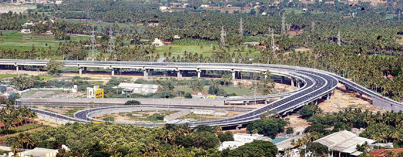
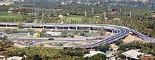 Salem ByPass NH 47 trumpet Grade interchange
 NH-47 Coimbatore-Salem stretch of North-South Corridor
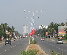 Kochi Bypass
Nearly 400 km (250 mi) of NH 47 between Cherthala and Salem passing through Kochi, Thrissur and Coimbatore is under various stages of expansion. The stretch from Thrissur to Cherthala passing through Kochi city has been widened to multiple lanes with with six-lanes in many stretches. The road widening has started at the Salem End of the Highway and the 4 lane work has been completed in the Salem-Chengapalli (Km 0 to 100) stretch and there is a new bridge built on the Cauvery river at Bhavani Kooduthurai. Widening to six lanes is in progress between Perumanallur and Coimbatore city). Also, widening is in progress from Thrissur to Walayar (Kerala- Tamil Nadu Border, Palakkad District, Kerala). Of this, the stretch from Mannuthy in Thrissur to Vadakkanchery in Palakkad District (30 km) would facilitate six-lane traffic while the 58 km segment from Vadakkanchery to Walayar would be four-lane. However, delays in land acquisition has put on hold the widening of NH47 from Cherthala to Kanyakumari through Kollam and Thiruvananthapuram.[6] The widening of Chengapalli-Walayar stretch of North-South corridor is in process,Of this, the first stretch from Chengapalli to Nilambur(Coimbatore) (42.705 km), where it would touch the already widened Coimbatore bypass, would facilitate six-lane traffic while the 12 km segment from Madukkarai(Coimbatore) to Walayar would be four-lane. Six laning from Chengapalli starts from Coimbatore Bypass section of NH-47 and Four lane from Madukarai on end of Coimbatore Bypass to Tamil nadu/Kerala Border up to Walayar section of NH-47 in the State of Tamil Nadu.[6]
New Number
As part of the rationalization of numbering effort, the govt has re-structured the highways in the country. The section of this highway between Salem and Kochi has been assigned the number NH 544, being a spur of the North-South corridor highway NH 44. The segment from Kochi to Kanyakumari is merged with NH 66, which was formerly called NH-17.
See also
- National Highways Development Project
- Coimbatore-Salem Industrial Corridor
References
- Openstreetmap
- ^ [1] National Highway 47
- ^ "National Highways and their lengths". National Highways Authority of India. http://www.nhai.org/nh.asp. Retrieved 2009-02-12.
- ^ "NS&EW Corridor Map". National Highway Authority of India. http://www.nhai.org/images/Nov10/NSEW%20%20%20Eng%20.jpg. Retrieved 2011-02-10.
- ^ "NS&EW Corridor Chainage Chart". National Highway Authority of India. http://www.nhai.org/chain_NS.asp. Retrieved 2011-02-10.
- ^ National Highway No. 47 Route: Maps of India
- ^ a b "Land acquisition issues may delay widening of NH 47". http://www.hindu.com/2009/12/04/stories/2009120451700300.htm.
Indian Highways Network National Expressways NE 1 • NE 2


State Expressways Mumbai-Pune • Delhi-Gurgaon • DND Flyway • Bengaluru-Mysore • Chennai HSCTC • Hyderabad Elevated ExpresswaysNational Highways 1 • 1A • 1B • 1C • 1D • 2 • 2A • 3 • 4 • 4A • 4B • 5 • 5A • 6 • 7 • 7A • 8 • 8A • 8B • 8C • 8D • 8E • 9 • 10 • 11 • 11A • 11B • 12 • 12A • 13 • 14 • 15 • 16 • 17 • 17A • 17B • 18 • 19 • 20 • 21 • 21A • 22 • 23 • 24 • 24A • 24B • 25 • 25A • 26 • 26A • 27 • 28 • 28A • 28B • 28C • 29 • 30 • 30A • 31 • 31A • 31B • 31C • 31D • 32 • 33 • 34 • 35 • 36 • 37 • 37A • 38 • 39 • 40 • 41 • 42 • 43 • 44 • 44A • 45 • 45A • 45B • 45C • 46 • 47 • 47A • 47B • 47C • 48 • 49 • 50 • 51 • 52 • 52A • 52B • 53 • 54 • 54A • 55 • 56 • 57 • 57A • 58 • 59 • 59A • 60 • 60A • 61 • 62 • 63 • 64 • 65 • 66 • 67 • 68 • 69 • 70 • 71 • 71A • 71B • 72 • 72A • 73 • 73A • 74 • 75 • 76 • 77 • 78 • 79 • 79A • 80 • 81 • 82 • 83 • 84 • 85 • 86 • 86A • 87 • 88 • 89 • 90 • 91 • 91A • 92 • 93 • 94 • 95 • 96 • 97 • 98 • 99 • 100 • 101 • 102 • 103 • 104 • 105 • 106 • 107 • 108 • 109 • 110 • 111 • 112 • 113 • 114 • 116 • 117 • 119 • 121 • 123 • 125 • 126 • 127 • 128 • 129 • 150 • 151 • 152 • 153 • 154 • 155 • 200 • 201 • 202 • 203 • 203A • 204 • 205 • 206 • 207 • 208 • 209 • 210 • 211 • 212 • 213 • 214 • 214A • 215 • 216 • 217 • 218 • 219 • 220 • 221 • 222 • 223 • 224 • 226 • 227 • 228 • 229 • 234 • 235State Highways Andhra Pradesh • Arunachal Pradesh • Assam • Bihar • Chhattisgarh • Goa • Gujarat • Haryana • Himachal Pradesh • Jammu and Kashmir • Jharkhand • Karnataka • Kerala • Madhya Pradesh • Maharashtra • Manipur • Meghalaya • Mizoram • Nagaland • Orissa • Punjab • Rajasthan • Sikkim • Tamil Nadu • Tripura • Uttarakhand • Uttar Pradesh • West BengalNotable Categories:- National Highways in Tamil Nadu
- National Highways in Kerala
- Indian National Highways


Wikimedia Foundation. 2010.