- National Highway 52 (India)
-
National Highway 52

52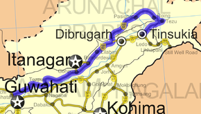
Road map of India with National Highway 52 highlighted in blueRoute information Length: 850 km (530 mi) Major junctions From: Baihata, Assam To: NH 37 Location States: Assam: 540 km (340 mi)
Arunachal Pradesh: 310 km (190 mi)Primary
destinations:Guwahati - Charali - Tezpur - Gohpur – North Lakhimpur - Pasighat - Tezu - Sitapani Junction with NH 37 near Saikhoaghat Highway system Indian Road Network
National • Expressways • State
State Highways in ¬← NH 51 NH 52A → National Highway 52 (NH 44) is a National Highway in the Northeastern Indian states of Assam and Arunachal Pradesh. NH 52 starts at the intersection of NH 31 north of Guwahati and generally traverses east and northeast. It runs for a distance of 850 km (530 mi), of which 540 km (340 mi) is in Assam and the rest in Arunachal Pradesh. [1]
NH 52A that links the Arunachal Pradesh state capital Itanagar is a spur route of NH 52.
See also
- List of National Highways in India (by Highway Number)
- National Highways Development Project
External links
- [1] NH 52 Map
References
- ^ "National Highways and their lengths". National Highways Authority of India. http://www.nhai.org/nh.asp. Retrieved 2009-02-12.
Indian Highways Network National Expressways NE 1 • NE 2


State Expressways Mumbai-Pune • Delhi-Gurgaon • DND Flyway • Bengaluru-Mysore • Chennai HSCTC • Hyderabad Elevated ExpresswaysNational Highways 1 • 1A • 1B • 1C • 1D • 2 • 2A • 3 • 4 • 4A • 4B • 5 • 5A • 6 • 7 • 7A • 8 • 8A • 8B • 8C • 8D • 8E • 9 • 10 • 11 • 11A • 11B • 12 • 12A • 13 • 14 • 15 • 16 • 17 • 17A • 17B • 18 • 19 • 20 • 21 • 21A • 22 • 23 • 24 • 24A • 24B • 25 • 25A • 26 • 26A • 27 • 28 • 28A • 28B • 28C • 29 • 30 • 30A • 31 • 31A • 31B • 31C • 31D • 32 • 33 • 34 • 35 • 36 • 37 • 37A • 38 • 39 • 40 • 41 • 42 • 43 • 44 • 44A • 45 • 45A • 45B • 45C • 46 • 47 • 47A • 47B • 47C • 48 • 49 • 50 • 51 • 52 • 52A • 52B • 53 • 54 • 54A • 55 • 56 • 57 • 57A • 58 • 59 • 59A • 60 • 60A • 61 • 62 • 63 • 64 • 65 • 66 • 67 • 68 • 69 • 70 • 71 • 71A • 71B • 72 • 72A • 73 • 73A • 74 • 75 • 76 • 77 • 78 • 79 • 79A • 80 • 81 • 82 • 83 • 84 • 85 • 86 • 86A • 87 • 88 • 89 • 90 • 91 • 91A • 92 • 93 • 94 • 95 • 96 • 97 • 98 • 99 • 100 • 101 • 102 • 103 • 104 • 105 • 106 • 107 • 108 • 109 • 110 • 111 • 112 • 113 • 114 • 116 • 117 • 119 • 121 • 123 • 125 • 126 • 127 • 128 • 129 • 150 • 151 • 152 • 153 • 154 • 155 • 200 • 201 • 202 • 203 • 203A • 204 • 205 • 206 • 207 • 208 • 209 • 210 • 211 • 212 • 213 • 214 • 214A • 215 • 216 • 217 • 218 • 219 • 220 • 221 • 222 • 223 • 224 • 226 • 227 • 228 • 229 • 234 • 235State Highways Andhra Pradesh • Arunachal Pradesh • Assam • Bihar • Chhattisgarh • Goa • Gujarat • Haryana • Himachal Pradesh • Jammu and Kashmir • Jharkhand • Karnataka • Kerala • Madhya Pradesh • Maharashtra • Manipur • Meghalaya • Mizoram • Nagaland • Orissa • Punjab • Rajasthan • Sikkim • Tamil Nadu • Tripura • Uttarakhand • Uttar Pradesh • West BengalNotable Categories:- National Highways in Assam
- National Highways in Arunachal Pradesh
- Indian National Highways
- India road stubs


Wikimedia Foundation. 2010.