- National Highway 9 (India)
-
National Highway 9 
Road map of India with National Highway 9 highlighted in solid blue colorRoute information Length: 841 km (523 mi) Major junctions West end: Pune, Maharashtra NH 4 in Pune
NH 5 in Vijayawada
NH 13 in Solapur
NH 211 in Solapur
NH 7 in Hyderabad
NH 202 in HyderabadEast end: Machilipatnam, Andhra Pradesh Location States: Maharashtra: 336 km
Karnataka: 75 km
Andhra Pradesh: 430 km (270 mi)Primary
destinations:Pune - Solapur - Zaheerabad - Hyderabad - Vijayawada - Machilipatnam Highway system Indian Road Network
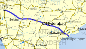
National • Expressways • State← NH 8E NH 10 → National Highway 9 (NH 9) is a major National Highway in central India passing through the states of Maharashtra, Karnataka and Andhra Pradesh. Its eastern terminal is in Machilipatnam in Andhra Pradesh and its western terminal is in Pune with a total length of 841 km (523 mi)[1].
Contents
Major Cities on the Route
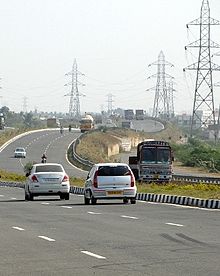
Major cities and towns on NH 9 are Pune, Indapur, Solapur, Umarga, Zahirabad, Hyderabad, Narketpally, Suryapet, Kodada, Vijayawada and Machilipatnam.The stretch from Zahirabad to Solapur is in a poor condition and it is going to be widen from Sangareddy to Zaheerabad this year. The stretches from Vijayawada to Hyderabad, Hyderabad to Sangareddi crossroads, and from Daund to Pune are well maintained.
The present road conditions from Daund to the state border of Maharashtra/Karnataka border has not been upgraded / maintained as the roads in the states of Karnataka and Andhra Pradesh. The road is not suitable for the large number of heavy trucks traveling between Pune and Vijayawada.
The NH-9, which begins at Pune in Maharashtra, extends over 841 km (523 mi) with 336 km (209 mi) in Maharashtra, 75 km (47 mi) in Karnataka and 430 km (270 mi) in Andhra Pradesh and ends at Machilipatnam. From Pune a 40 km (25 mi) stretch has been developed into a good quality 4 lane highway, a similar development has taken place 40 km (25 mi)before and after Hyderabad and 50 km (31 mi) before Vijayawada had been developed into 4 lane. However, waiting is for the development of the remaining 700 km (430 mi).
The highway number is now changed to National Highway #65.
Four / Six Laning
The long-awaited four/six-laning of Hyderabad-Vijayawada section of NH 9 has started following the laying of foundation stone on 21st March 2010[2]. Once four/six-laning work is completed, it would fulfill long cherished dream of people of the Eastern parts of Andhra Pradesh to have faster access to the capital. It would help a lot in reducing the travel time between Hyderabad and Vijayawada.
Once the implementation of the project is complete, there would be substantial decrease in vehicle operating costs like reduced travel time between Hyderabad and Vijayawada from four to three hours for private car users and from six to four hours for public transport users considering the stop at Suryapet and Kodada and other towns to pick up passengers. There are six bypasses through Narketpally, Nakrekal, Kodad, Akupamula, Sher Mohammed Peta and Navabpet. The expansion project from Hyderabad to Vijayawada on NH-9 was taken up at an estimated cost of Rs 1,170 crore on Build, Operate and Transfer (BOT) basis. The project also envisages augmenting the four-lane facility to six-lane standards before 14th year. This project which was sanctioned in November 2007 was delayed a lot thanks to Reliance Infrastructure and other companies[3] which created legal problems in addition to technical reasons besides land acquisition delays.Work on Hyderabad-Vijayawada section to be completed by Oct. 2012.
References
External links
- NH 9 Map
- Feasibility and Detailed Project Report for 4/6 Laning of Hyderabad-Vijayawada and Vijayawada-Machilipatnam Under NHDP Phase III
See also
- List of National Highways in India (by Highway Number)
- National Highways Development Project
Indian Highways Network National Expressways NE 1 • NE 2

State Expressways Mumbai-Pune • Delhi-Gurgaon • DND Flyway • Bengaluru-Mysore • Chennai HSCTC • Hyderabad Elevated ExpresswaysNational Highways 1 • 1A • 1B • 1C • 1D • 2 • 2A • 3 • 4 • 4A • 4B • 5 • 5A • 6 • 7 • 7A • 8 • 8A • 8B • 8C • 8D • 8E • 9 • 10 • 11 • 11A • 11B • 12 • 12A • 13 • 14 • 15 • 16 • 17 • 17A • 17B • 18 • 19 • 20 • 21 • 21A • 22 • 23 • 24 • 24A • 24B • 25 • 25A • 26 • 26A • 27 • 28 • 28A • 28B • 28C • 29 • 30 • 30A • 31 • 31A • 31B • 31C • 31D • 32 • 33 • 34 • 35 • 36 • 37 • 37A • 38 • 39 • 40 • 41 • 42 • 43 • 44 • 44A • 45 • 45A • 45B • 45C • 46 • 47 • 47A • 47B • 47C • 48 • 49 • 50 • 51 • 52 • 52A • 52B • 53 • 54 • 54A • 55 • 56 • 57 • 57A • 58 • 59 • 59A • 60 • 60A • 61 • 62 • 63 • 64 • 65 • 66 • 67 • 68 • 69 • 70 • 71 • 71A • 71B • 72 • 72A • 73 • 73A • 74 • 75 • 76 • 77 • 78 • 79 • 79A • 80 • 81 • 82 • 83 • 84 • 85 • 86 • 86A • 87 • 88 • 89 • 90 • 91 • 91A • 92 • 93 • 94 • 95 • 96 • 97 • 98 • 99 • 100 • 101 • 102 • 103 • 104 • 105 • 106 • 107 • 108 • 109 • 110 • 111 • 112 • 113 • 114 • 116 • 117 • 119 • 121 • 123 • 125 • 126 • 127 • 128 • 129 • 150 • 151 • 152 • 153 • 154 • 155 • 200 • 201 • 202 • 203 • 203A • 204 • 205 • 206 • 207 • 208 • 209 • 210 • 211 • 212 • 213 • 214 • 214A • 215 • 216 • 217 • 218 • 219 • 220 • 221 • 222 • 223 • 224 • 226 • 227 • 228 • 229 • 234 • 235State Highways Andhra Pradesh • Arunachal Pradesh • Assam • Bihar • Chhattisgarh • Goa • Gujarat • Haryana • Himachal Pradesh • Jammu and Kashmir • Jharkhand • Karnataka • Kerala • Madhya Pradesh • Maharashtra • Manipur • Meghalaya • Mizoram • Nagaland • Orissa • Punjab • Rajasthan • Sikkim • Tamil Nadu • Tripura • Uttarakhand • Uttar Pradesh • West BengalNotable Categories:- National Highways in Maharashtra
- National Highways in Karnataka
- National Highways in Andhra Pradesh
- Indian National Highways
- India road stubs
Wikimedia Foundation. 2010.


