- National Highway 35 (India)
-
National Highway 35 
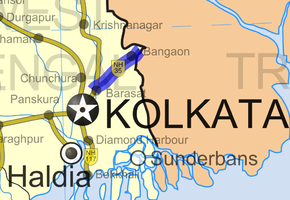
Road map of India with National Highway 35 highlighted in blueRoute information Part of AH1 Length: 60 km (40 mi) Major junctions From: Barasat To: Petrapole Location States: West Bengal Primary
destinations:Habra–Gaighata–Bangaon Highway system Indian Road Network
National • Expressways • State
State Highways in ¬← NH 34 NH 36 → National Highway 35 or NH 35 runs from Barasat to Petrapole on the India–Bangladesh border. It links to Benapole in Bangladesh. Earlier, the road from Dum Dum to Jessore was called Jessore Road. While the Dum Dum–Barasat sector is now part of NH 34, the Barasat–Petrapole sector is now part of NH 35.
Total length of NH 35 is 60 kilometres (37 mi).[1]
Contents
Bus service
There is a regular bus service between Dhaka and Kolkata along this national highway. The Government sponsored bus service was launched on June 19, 1999; the inaugural bus was received in Dhaka by Sheikh Hasina, the then-Prime Minister of Bangladesh.[2]
Traffic
According to study by RITES in 2006, the goods traffic at Petrapole was approximately 400 trucks per day both ways, while the 2006 passenger traffic was about 1,159 people per day (both incoming and outgoing). The total traffic in 2029-30 has been projected as 2,938 trucks per day and the passenger traffic by then will be 3,924 people per day. [3]
References
- ^ "National Highways and their lengths". National Highways Authority of India. http://www.nhai.org/nh.asp. Retrieved 2009-02-12.
- ^ Malhotra, Jyoti (June 18, 1999). "Bus maps the route to better Indo-Bangla ties". expressindia.com (The Indian Express). http://www.indianexpress.com/res/web/pIe/ie/daily/19990618/ige18050.html. Retrieved 2009-02-12.
- ^ "Petrapole infrastructure to be beefed up". The Hindu Business Line 18 June 2006. http://www.thehindubusinessline.com/2006/06/18/stories/2006061802970300.htm. Retrieved 2009-02-12.
See also
- List of National Highways in India
- List of National Highways in India (by Highway Number)
- National Highways Development Project
Indian Highways Network National Expressways NE 1 • NE 2

State Expressways Mumbai-Pune • Delhi-Gurgaon • DND Flyway • Bengaluru-Mysore • Chennai HSCTC • Hyderabad Elevated ExpresswaysNational Highways 1 • 1A • 1B • 1C • 1D • 2 • 2A • 3 • 4 • 4A • 4B • 5 • 5A • 6 • 7 • 7A • 8 • 8A • 8B • 8C • 8D • 8E • 9 • 10 • 11 • 11A • 11B • 12 • 12A • 13 • 14 • 15 • 16 • 17 • 17A • 17B • 18 • 19 • 20 • 21 • 21A • 22 • 23 • 24 • 24A • 24B • 25 • 25A • 26 • 26A • 27 • 28 • 28A • 28B • 28C • 29 • 30 • 30A • 31 • 31A • 31B • 31C • 31D • 32 • 33 • 34 • 35 • 36 • 37 • 37A • 38 • 39 • 40 • 41 • 42 • 43 • 44 • 44A • 45 • 45A • 45B • 45C • 46 • 47 • 47A • 47B • 47C • 48 • 49 • 50 • 51 • 52 • 52A • 52B • 53 • 54 • 54A • 55 • 56 • 57 • 57A • 58 • 59 • 59A • 60 • 60A • 61 • 62 • 63 • 64 • 65 • 66 • 67 • 68 • 69 • 70 • 71 • 71A • 71B • 72 • 72A • 73 • 73A • 74 • 75 • 76 • 77 • 78 • 79 • 79A • 80 • 81 • 82 • 83 • 84 • 85 • 86 • 86A • 87 • 88 • 89 • 90 • 91 • 91A • 92 • 93 • 94 • 95 • 96 • 97 • 98 • 99 • 100 • 101 • 102 • 103 • 104 • 105 • 106 • 107 • 108 • 109 • 110 • 111 • 112 • 113 • 114 • 116 • 117 • 119 • 121 • 123 • 125 • 126 • 127 • 128 • 129 • 150 • 151 • 152 • 153 • 154 • 155 • 200 • 201 • 202 • 203 • 203A • 204 • 205 • 206 • 207 • 208 • 209 • 210 • 211 • 212 • 213 • 214 • 214A • 215 • 216 • 217 • 218 • 219 • 220 • 221 • 222 • 223 • 224 • 226 • 227 • 228 • 229 • 234 • 235State Highways Andhra Pradesh • Arunachal Pradesh • Assam • Bihar • Chhattisgarh • Goa • Gujarat • Haryana • Himachal Pradesh • Jammu and Kashmir • Jharkhand • Karnataka • Kerala • Madhya Pradesh • Maharashtra • Manipur • Meghalaya • Mizoram • Nagaland • Orissa • Punjab • Rajasthan • Sikkim • Tamil Nadu • Tripura • Uttarakhand • Uttar Pradesh • West BengalNotable Categories:- India road stubs
- National Highways in West Bengal
- Indian National Highways
Wikimedia Foundation. 2010.


