- National Highway 6 (India)
-
National Highway 6

6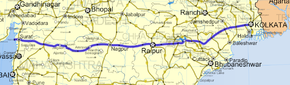
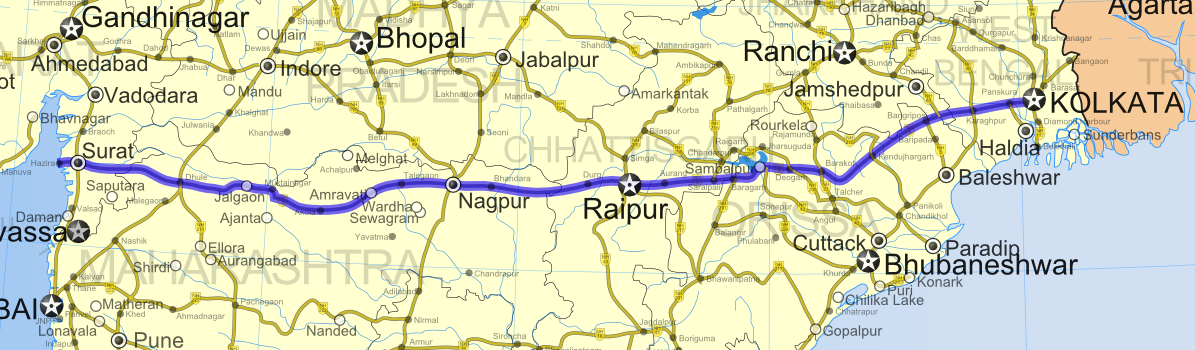
Road map of India with National Highway 6 highlighted in solid blue colorRoute information Length: 1,949 km (1,211 mi)
GQ: 117 km (73 mi) (Kolkata - Kharagpur)
Phase III: 358 km (222 mi)Major junctions West end: Hajira, Gujarat East end: Kolkata, West Bengal Location States: Gujarat: 177 km (110 mi)
Maharashtra: 813 km (505 mi)
Chhatisgarh: 314 km (195 mi)
Orissa: 412 km (256 mi)
Jharkhand: 22 km (14 mi)
West Bengal: 161 km (100 mi)Primary
destinations:Surat - Dhule - Amravati - Nagpur - Durg - Raipur - Sambalpur - Baharagora - Kolkata Highway system Indian Road Network
National • Expressways • State
State Highways in ¬← NH 5A NH 7 → National Highway 6, commonly referred to as NH 6 or the G.E. Road (Great Eastern Road), is a busy National Highway in India that runs through Gujarat, Maharashtra, Chhattisgarh, Orissa, Jharkhand and West Bengal state in India. The highway passes through the cities of Surat, Dhule, Nagpur, Durg, Raipur, Sambalpur, Kolkata. The road is the part of National Highway network of India, and it is officially listed as running over 1,949 km (1,211 mi)from Hazira to Kolkata. [1]
Contents
Junctions
- At Kadodara Near Surat with NH 8 connecting Delhi - Jaipur - Ahmedabad - Mumbai
- At Dhule with NH 3 connecting Agra - Indore - Mumbai
- At Dhule with NH 211 connecting Solapur - Aurangabad - Dhule
- At Nagpur with NH 7 connecting Varanasi - Jabalpur - Nagpur - Hyderabad - Bangalore - Kanyakumari
- At Nagpur with NH 69 connecting Nagpur - Betul - Obedullaganj near Bhopal
- At Raipur with NH 43 connecting Raipur - Jagdalpur - Borigumma - Koraput - Salur - Vizianagaram on NH 5
- At Raipur with NH 200 connecting Raipur - Bilaspur - Raigarh - Deogarh- Talcher - Chandikhol
- At Raipur with NH 217 connecting Raipur - Titlagarh - Asika - Gopalpur
- At Bargarh with NH 201 connecting Borigumma on NH 43 - Bhawanipatna - Balangir - Bargarh
- At Sambalpur with NH 42 connecting Sambalpur - Angul - Dhenkanal - Cuttack on NH 5
- Near Deogarh with NH 200 ( for Second time ) connecting Raipur - Bilaspur - Raigarh - Deogarh - Talcher - Chandikhol on NH 5
- Near Barkote with NH 23 connecting Chas on NH 32 - Ranchi - Raurkela - Barkote - Pal Lahara - Talcher - Nauhata on NH 42
- At Pal Lahara with NH 23 connecting Chas on NH 32 - Ranchi - Raurkela - Barkote - Pal Lahara - Talcher - Nauhata on NH 42
- At Kendujhargarh with NH 215 connecting Panikoili - Anandapur - Kendujhargarh - Rajamunda on NH 23
- At Jharpokharia with NH 5 connectioning Jharpokharia - Cuttack - Vijayawada - Chennai
- At Baharagora with NH 33 connecting Baharagora - Jamshedpur - Ranchi - Hazaribag - Barhi on NH 2
- At Kharagpur with NH 60 connecting Balasore on NH 5 - Jaleswar - Kharagpur - Bankura - Raniganj - junction with NH 2
- At Kolaghat with NH 41 connecting Tamluk - Haldia
- At Kolkata with NH 2 connecting Kolkata - Varanasi - Kanpur - Delhi
States, Districts, Cities, towns and villages connected
 NH 6
NH 6
Many cities and towns in various districts in the States of Gujrat, Maharashtra, Chhatisgarh, Orissa, Jharkhand and West Bengal are connected by National Highway 6.
Gujarat
- Surat district
- Hajira - Surat - Sachin, Gujarat - Palsana - Bardoli
- Tapi district
Maharashtra
- Nandurbar District
- Dhule District
- Jalgaon District
- Buldhana District
- Akola District
- Balapur - Akola - BorgaonManju - Kurankhed - Murtajapur
- Amravati District
- Wardha District
- Talegaon - Karanja
- Nagpur District
- Bhandara District
- Gondia District
- Kohmara - Duggipar - Deori
Chhattisgarh
- Rajnandgaon District
- Baghnadi - Chichola - Rajnandgaon
- Durg District
- Raipur District
- Raipur - Arang
- Mahasamund District
Orissa
- Bargarh District
- Lobarchatti - Sohela - Bargarh - Attabira
- Sambalpur District
- Debagarh District
- Angul District
- Kendujhargarh District
- Govindpur - Kuanr - Kendujhargarh
- Mayurbhanj District
- Jashipur - Manda - Bangriposi - Jharpokharia
Jharkhand
- East Singhbhum District
West Bengal
- Paschim Medinipur District
- Purba Medinipur District
- Howrah District
- Kolkata District
Trivia
- The stretch between Barkote and Pal Lahara looks common between NH 6 and NH 23
- NH 200 crosses NH 6 at two locations, one at starting point at Raipur and second at Deogarh
External links
See also
- List of National Highways in India (by Highway Number)
References
Indian Highways Network National Expressways NE 1 • NE 2


State Expressways Mumbai-Pune • Delhi-Gurgaon • DND Flyway • Bengaluru-Mysore • Chennai HSCTC • Hyderabad Elevated ExpresswaysNational Highways 1 • 1A • 1B • 1C • 1D • 2 • 2A • 3 • 4 • 4A • 4B • 5 • 5A • 6 • 7 • 7A • 8 • 8A • 8B • 8C • 8D • 8E • 9 • 10 • 11 • 11A • 11B • 12 • 12A • 13 • 14 • 15 • 16 • 17 • 17A • 17B • 18 • 19 • 20 • 21 • 21A • 22 • 23 • 24 • 24A • 24B • 25 • 25A • 26 • 26A • 27 • 28 • 28A • 28B • 28C • 29 • 30 • 30A • 31 • 31A • 31B • 31C • 31D • 32 • 33 • 34 • 35 • 36 • 37 • 37A • 38 • 39 • 40 • 41 • 42 • 43 • 44 • 44A • 45 • 45A • 45B • 45C • 46 • 47 • 47A • 47B • 47C • 48 • 49 • 50 • 51 • 52 • 52A • 52B • 53 • 54 • 54A • 55 • 56 • 57 • 57A • 58 • 59 • 59A • 60 • 60A • 61 • 62 • 63 • 64 • 65 • 66 • 67 • 68 • 69 • 70 • 71 • 71A • 71B • 72 • 72A • 73 • 73A • 74 • 75 • 76 • 77 • 78 • 79 • 79A • 80 • 81 • 82 • 83 • 84 • 85 • 86 • 86A • 87 • 88 • 89 • 90 • 91 • 91A • 92 • 93 • 94 • 95 • 96 • 97 • 98 • 99 • 100 • 101 • 102 • 103 • 104 • 105 • 106 • 107 • 108 • 109 • 110 • 111 • 112 • 113 • 114 • 116 • 117 • 119 • 121 • 123 • 125 • 126 • 127 • 128 • 129 • 150 • 151 • 152 • 153 • 154 • 155 • 200 • 201 • 202 • 203 • 203A • 204 • 205 • 206 • 207 • 208 • 209 • 210 • 211 • 212 • 213 • 214 • 214A • 215 • 216 • 217 • 218 • 219 • 220 • 221 • 222 • 223 • 224 • 226 • 227 • 228 • 229 • 234 • 235State Highways Andhra Pradesh • Arunachal Pradesh • Assam • Bihar • Chhattisgarh • Goa • Gujarat • Haryana • Himachal Pradesh • Jammu and Kashmir • Jharkhand • Karnataka • Kerala • Madhya Pradesh • Maharashtra • Manipur • Meghalaya • Mizoram • Nagaland • Orissa • Punjab • Rajasthan • Sikkim • Tamil Nadu • Tripura • Uttarakhand • Uttar Pradesh • West BengalNotable Categories:- National Highways in Gujarat
- National Highways in Maharashtra
- National Highways in Chhattisgarh
- National Highways in Orissa
- National Highways in Jharkhand
- National Highways in West Bengal
- Golden Quadrilateral
- Indian National Highways
- Transport in Sambalpur


Wikimedia Foundation. 2010.