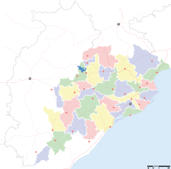
- Debagarh district
-
Debagarh — district — Coordinates 21°31′59″N 84°43′59″E / 21.533°N 84.733°ECoordinates: 21°31′59″N 84°43′59″E / 21.533°N 84.733°E Country India State Orissa Headquarters Debagarh Collector Sri Ambika Prasad Mishra, I.A.S Assembly constituency 1, Debagarh Population
• Density
312,164 (30) (2011[update])
• 106 /km2 (275 /sq mi)
Sex ratio 976 ♂/♀ Literacy
• Male
• Female73.07%
• 82.62%
• 63.36%Official languages Oriya, Hindi, English Time zone IST (UTC+05:30) Area 2,781.66 square kilometres (1,074.00 sq mi) Climate
Aw (Köppen)
• 1,014.2 mm (39.93 in)
Codes-
• Pincode • 768 xxx
Website deogarh.nic.in Debagarh District, also known as Deogarh District, is a district of Orissa state, India. It is located in the northern part of the state. Debagarh is the district headquarters. The district covers an area of 2781.66 km². The district has a population of 274,095 (2001 Census). As of 2011 it is the least populous district of Orissa (out of 30).[1]
Contents
History
The district was created on 1 January 1994 by bifurcating the erstwhile Sambalpur district. It is currently a part of the Red Corridor.[2]
Economy
In 2006 the Ministry of Panchayati Raj named Debagarh one of the country's 250 most backward districts (out of a total of 640).[3] It is one of the 19 districts in Orissa currently receiving funds from the Backward Regions Grant Fund Programme (BRGF).[3]
Education
There are a number of educational institutes are present out of which Raja Basu Dev High School(Oriya: ରାଜା ଵାସୁ ଦେବ ଉଚ୍ଚ ବିଦ୍ୟାଳୟ) and Govt. collage at Debagarh town are some of them.
Demographics
According to the 2011 census Debagarh district has a population of 312,164 ,[1] roughly equal to the nation of Iceland.[4] This gives it a ranking of 571st in India (out of a total of 640).[1] The district has a population density of 106 inhabitants per square kilometre (270 /sq mi) .[1] Its population growth rate over the decade 2001-2011 was 13.88 %.[1] Debagarh has a sex ratio of 976 females for every 1000 males,[1] and a literacy rate of 73.07 %.[1]
References
- ^ a b c d e f g "District Census 2011". Census2011.co.in. 2011. http://www.census2011.co.in/district.php. Retrieved 2011-09-30.
- ^ "83 districts under the Security Related Expenditure Scheme". IntelliBriefs. 2009-12-11. http://intellibriefs.blogspot.com/2009/12/naxal-menace-83-districts-under.html. Retrieved 2011-09-17.
- ^ a b Ministry of Panchayati Raj (September 8, 2009). "A Note on the Backward Regions Grant Fund Programme". National Institute of Rural Development. http://www.nird.org.in/brgf/doc/brgf_BackgroundNote.pdf. Retrieved September 27, 2011.
- ^ US Directorate of Intelligence. "Country Comparison:Population". https://www.cia.gov/library/publications/the-world-factbook/rankorder/2119rank.html. Retrieved 2011-10-01. "Iceland 311,058 July 2011 est."
External links

Sundargarh district 

 Debagarh district

Sambalpur district Anugul district State of Orissa · 
Capital 
Topics Districts Angul · Balasore · Bargarh · Bhadrak · Balangir · Boudh · Cuttack · Debagarh · Dhenkanal · Gajapati · Ganjam · Jagatsinghpur · Jajpur · Jharsuguda · Kalahandi · Kandhamal · Kendrapara · Kendujhar · Khordha · Koraput · Malkangiri · Mayurbhanj · Nabarangpur · Nayagarh · Nuapada · Puri · Rayagada · Sambalpur · Subarnapur · Sundargarh
Cities Cities and towns in Debagarh district Debagarh Cities and towns
in other districtsAngul · Balangir · Balasore · Bargarh · Boudh · Bhadrak · Cuttack · Dhenkanal · Gajapati · Ganjam · Jagatsinghpur · Jajpur · Jharsuguda · Kalahandi · Kandhamal · Kendrapara · Kendujhar · Khordha · Koraput · Malkangiri · Mayurbhanj · Nabarangpur · Nayagarh · Nuapada · Puri · Rayagada · Sambalpur · Subarnapur · Sundergarh
Districts of Orissa Angul · Balangir · Balasore · Bargarh · Bhadrak · Boudh · Cuttack · Debagarh · Dhenkanal · Gajapati · Ganjam · Jagatsinghpur · Jajpur · Jharsuguda · Kalahandi · Kandhamal · Kendrapara · Kendujhar · Khordha · Koraput · Malkangiri · Mayurbhanj · Nabarangpur · Nayagarh · Nuapada · Puri · Rayagada · Sambalpur · Subarnapur · SundergarhCategories:- Debagarh district
- Orissa geography stubs
-
Wikimedia Foundation. 2010.


