- States and territories of India
-
India is a federal union of states[1] comprising twenty-eight states and seven union territories. The states and territories are further subdivided into districts and so on.[1]
Contents
List of states and territories
A clickable map of India exhibiting its 28 states and 7 union territories.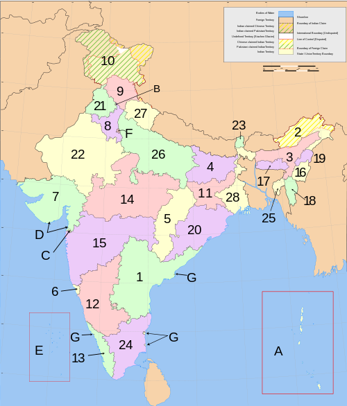

The Census 2011 codes given in the table have been assigned by Census India from North-West to South-East.
States of India Name ISO 3266-2 code Andhra Pradesh AP 280 84,665,533 275,045 Telugu, Urdu Hyderabad 23 28,123 210 308 67.66 27.3 992na 961 Arunachal Pradesh AR 120 1,382,611 83,743 Itanagar 16 4,065 17 17 66.95 20.8 920 964 Assam AS 180 31,169,272 78,550 Assamese, Bodo, Rabha dialect, Deori, Bengali Dispur Guwahati 23 26,312 125 397 73.18 12.9 954 965 Bihar BR 100 103,804,637 99,200 Hindi, Bhojpuri, Maithili, Magadhi Patna 37 45,098 130 1102 63.82 10.5 916 942 Chhattisgarh CT 220 25,540,196 135,194 Chattisgarhi, Hindi Raipur 16 20,308 97 189 71.04 20.1 991 975 Goa GA 300 1,457,723 3,702 Konkani, Marathi Panaji Vasco da Gama 2 359 44 394 87.40 49.8 968 938 Gujarat GJ 240 60,383,628 196,024 Gujarati Gandhinagar Ahmedabad 25 18,539 242 308 79.31 37.4 918 883 Haryana HR 060 25,353,081 44,212 Haryanvi (Western Hindi) Chandigarh
(shared, Union Territory)Faridabad 21 6,955 106 573 76.64 28.9 877 819 Himachal Pradesh HP 020 6,856,509 55,673 Western Hindi Shimla 12 20,118 57 123 83.78 9.8 920 896 Jammu and Kashmir JK 010 12,548,926 222,236 Kashmiri, Dogri Srinagar (summer)
Jammu (winter)14 6,652 75 124 68.74 24.8 883 941 Jharkhand JH 200 32,966,238 74,677 Hindi Ranchi Jamshedpur 24 32,615 152 414 67.63 22.2 947 965 Karnataka KA 290 61,130,704 191,791 Kannada Bengaluru 30 29,406 270 319 75.60 34.0 968 946 Kerala KL 320 33,387,677 38,863 Malayalam Thiruvananthapuram 14 1,364 159 859 93.91 26.0 1,084 960 Madhya Pradesh MP 230 72,597,565 308,252 Hindi Bhopal 45 55,393 394 236 70.63 26.5 930 932 Maharashtra MH 270 112,372,972 307,713 Marathi Mumbai 35 43,711 378 365 82.91 42.4 925 913 Manipur MN 140 2,721,756 22,347 Manipuri Imphal 9 2,391 33 122 79.85 25.1 987 957 Meghalaya ML 170 2,964,007 22,720 Khasi, Pnar Shillong 7 6,026 16 132 75.48 19.6 986 973 Mizoram MZ 150 1,091,014 21,081 Mizo Aizawl 8 817 22 52 91.58 49.6 975 964 Nagaland NL 130 1,980,602 16,579 Angami, Ao languages, Chang, Chakhesang, Konyak, and Sema Kohima Dimapur 11 1,317 9 119 80.11 17.2 931 964 Orissa OR 210 41,947,358 155,820 Oriya Bhubaneswar 30 51,349 138 269 73.45 15.0 978 953 Punjab PJ 030 27,704,236 50,362 Punjabi Chandigarh
(shared, Union Territory)Ludhiana 17 12,673 157 550 76.68 33.9 893 798 Rajasthan RJ 080 68,621,012 342,269 Rajasthani
(Western Hindi)Jaipur 32 41,353 222 201 67.06 23.4 926 909 Sikkim SK 110 607,688 7,096 Nepali Gangtok 4 452 9 86 82.20 11.1 889 963 Tamil Nadu TN 330 72,138,958 130,058 Tamil Chennai 30 16,317 832 480 80.33 44.0 995 942 Tripura TR 160 3,671,032 10,491.69 Bengali Agartala 4 870 23 555 87.75 17.1 961 966 Uttar Pradesh UP 090 199,581,477 243,286 Hindi, Urdu[2] Lucknow Kanpur 72 107,452 704 828 69.72 20.8 908 916 Uttarakhand UL 050 10,116,752 53,566 Western Hindi Dehradun (interim) 13 16,826 86 189 79.63 25.7 963 908 West Bengal WB 190 91,347,736 88,752 Bengali, Urdu, Nepali, Santali Kolkata 18 40,782 375 1,029 77.08 28.0 947 960 -Total- 637,643 5,082 Union Territories Name Population Language Capital Largest city No. of Districts No. of Villages No. of Towns Population density Literacy Rate(%) Percentage of Urban Population to total Population Sex Ratio Sex Ratio(0-6) Andaman and Nicobar Islands 379,944 Bengali Port Blair 2 547 3 46 86.27 32.6 878 957 Chandigarh 1,054,686 Punjabi Chandigarh 1 24 1 9,252 86.43 89.8 818 845 Dadra and Nagar Haveli 342,853 Marathi and Gujarati Silvassa 1 70 2 698 77.65 22.9 775 979 Daman and Diu 242,911 Gujarati Daman 2 23 2 2169 87.07 36.2 618 926 Lakshadweep 64,429 Malayalam Kavaratti Andrott 1 24 3 2013 92.28 44.5 946 959 National Capital Territory of Delhi 16,753,235 Hindi New Delhi 9 165 62 11,297 86.34 93.2 866 868 Puducherry 1,244,464 French and Tamil Pondicherry 4 92 6 2,598 86.55 66.6 1,038 967 Responsibilities and authorities of the states compared to the national government
The Constitution of India distributes the sovereign powers exercisable with respect to the territory of any State between the Union and that State. "Article 73 broadly stated, provides that the executive power of the Union shall extend to the matters with respect to which Parliament has power to make laws. Article 162 similarly provides that the executive power of a State shall extend to the matters with respect to which the Legislature of a State has power to make laws. The Supreme Court has reiterated this position when it ruled in the Ramanaiah case that the executive power of the Union or of the State broadly speaking, is coextensive and coterminous with its respective legislative power." (italics in original)[3]
History
Pre-1956
States and
territories of India by:Area Population Highest Point GDP HDI Tax revenues Voters Abbreviations Natural growth rate Sex ratio Vaccination Literacy rate Electricity Capitals Media exposure Origin of name HIV awareness Household size Underweight people Place of worship TV ownership Transport network Power capacity Institutional Delivery Life Expectancy at birth
The subcontinent of India has been ruled by many different ethnic groups throughout its history, each imposing their own administrative divisions on the region.[citation needed]After 1956
The former French and Portuguese colonies in India were incorporated into the Republic as the union territories of Puducherry, Dadra and Nagar Haveli, Goa, Daman and Diu in 1962.
Several new states and union territories have been created out of existing states since 1956. Bombay State was split into the linguistic states of Gujarat and Maharashtra on 1 May 1960[4] by the Bombay Reorganization Act. Nagaland was made a state on 1 December 1963.[5] The Punjab Reorganization Act of 1966 divided the Punjab along linguistic lines, creating a new Hindi-speaking state of Haryana on 1 November,[6] transferring the northern districts of Punjab to Himachal Pradesh, and designating Chandigarh, the shared capital of Punjab and Haryana, a union territory.[citation needed]
Statehood was conferred upon Himachal Pradesh[7] on 25 January 1971, Manipur, Meghalaya and Tripura[8] on 21 January 1972 the Kingdom of Sikkim joined the Indian Union as a state on 26 April 1975.[9] In 1987, Arunachal Pradesh and Mizoram became states on 20 February, followed by Goa on 30 May, while Goa's northern exclaves of Daman and Diu became a separate union territory.[10]
In 2000 three new states were created; Chhattisgarh (1 November 2000) was created out of eastern Madhya Pradesh, Uttaranchal (9 November 2000), since renamed Uttarakhand, was created out of the Hilly regions of northwest Uttar Pradesh, and Jharkhand (15 November 2000) was created out of the southern districts of Bihar.[citation needed] The Union Territories of Delhi and Puducherry have since been given the right to elect their own legislatures and they are now counted as small states
Proposals
Ahead of the 2009 General Elections in India, all the major parties in Andhra Pradesh supported statehood for Telangana. On 11:30 PM 9 December 2009, Mr. P. Chidambaram, Union Minister of Home Affairs, on behalf of the Government of India, announced that a resolution in the Andhra Pradesh assembly for the creation of a separate Telangana state would be passed. Mr. Chidambaram also stated that the process for the formation of a separate Telangana state would be initiated. It was not clear if this initiation of the process meant discussion with everyone involved on how to divide the state or whether the division of the state was being officially announced.
As a result of this unilateral decision by the Government of India, several members of Andhra Pradesh's legislature submitted their resignations to protest the creation of the new state owing to the pressure from the people in their constituencies.[11] As of 11 December, at least 117 legislators and many Members of Parliament had resigned in protest of the Government's decision to carve out a new state of Telangana.[12]
Due to the unexpected turn of events, after the parties which promised support to the Telangana state formation on 7 December 2009 in a unanimous all-party meeting at the State level, presided by CM, Rosaiah, and later the party members of these parties made a U-turn on their support bowing to the pressure from the people in their constituency following the 9 December statement (in support of Telangana state process initiation), the federal government made another statement on 23 December to clarify its intention on the process that it would consult with all groups, political and non-political, before moving forward. It then formed the Justice Sri Krishna committee which has been touring the state consulting with different sections of the society. A report recommending a solution suitable to all constituents is expected to be submitted before 31 December 2010.[13]
In November 2011 Mayawati, the chief minister of Uttar Pradesh, proposed dividing it into four states, Avadh Pradesh, Bundelkhand, Paschim Pradesh, and Purvanchal. On 21 November this movement was backed through a "voice vote" by the state assembly, despite criticism from the opposition and claims that the move was made to gain support for the next state election. It must gain the approval of the federal government, however this may be difficult due to the opposition to the creation of Telangana.[14]
See also
- Adjectivals and demonyms for states and territories of India
- Aspirant states of India
- Autonomous regions of India
- Emblems of Indian States
- ISO 3166-2:IN
- List of states and union territories of India by population
- Subdivisions of India
References
- ^ a b "States and union territories". http://www.india.gov.in/knowindia/state_uts.php. Retrieved 2007-09-07.
- ^ http://uplegassembly.nic.in/UPLL.HTML
- ^ Territoriality of executive powers of states in India, Balwant Singh Malik, Constitutional Law, 1998.
- ^ J.C. Aggarwal and S.P. Agrawal, editors, Uttarakhand: Past, Present, and Future (New Delhi: Concept Publishing, 1995), p89-90
- ^ Nagaland History & Geography-Source india.gov.in
- ^ The Punjab Reorganization Act 1966
- ^ Statehood Himachal Pradesh
- ^ Snapshot of North Eastern States
- ^ Sikkim joins Indian Inion
- ^ Goa Chronology
- ^ Press Trust of India (10 December 2009). "60 AP MLAs submit resignation to protest Telangana creation". Business Standard. http://www.business-standard.com/india/news/60-ap-mlas-submit-resignation-to-protest-telangana-creation/80453/on. Retrieved 10 December 2009.
- ^ "Telangana: Shutdown in Andhra Pradesh, 117 legislators quit". Times of India. 11 December 2009. http://timesofindia.indiatimes.com/india/Telangana-Shutdown-in-Andhra-Pradesh-117-legislators-quit/articleshow/5325650.cms. Retrieved 10 December 2009.
- ^ "Srikrishna report by Dec. 31". Deccan Chronicle. 27 October 2010. http://www.deccanchronicle.com/hyderabad/srikrishna-report-dec-31-897. Retrieved 10 November 2010.
- ^ "India: Uttar Pradesh assembly backs state division". BBC News. 21 November 2011. http://www.bbc.co.uk/news/world-asia-15814828. Retrieved 21 November 2011.
External links
States and territories of India States 
Union Territories Topics related to Geography of India Climate Geology Geology · Geological historyLandforms Beaches · Desert · Extreme points · Glaciers · Islands · Lakes · Mountains · Rivers · Valleys · Volcanoes · Waterfalls
Plains (Gangetic Plains · Eastern Coastal · Western Coastal)Regions Subdivisions Environment Biosphere Reserves · Ecoregions · Fauna · Flora · National Parks · Protected Areas · Sanctuaries · WildlifeArticles on first-level administrative divisions of Asian countries Afghanistan · Armenia · Azerbaijan1 · Bahrain · Bangladesh · Bhutan · Brunei · Burma · Cambodia · People's Republic of China · Cyprus · Egypt1 · Georgia1 · India · Indonesia1 · Iran · Iraq · Israel · Japan · Jordan · Kazakhstan1 · North Korea · South Korea · Kuwait · Kyrgyzstan · Laos · Lebanon · Malaysia · Maldives · Mongolia · Nepal · Oman · Pakistan · Palestine · Philippines · Qatar · Russia1 · Saudi Arabia · Singapore · Sri Lanka · Syria · Republic of China (Taiwan) · Tajikistan · Thailand · Timor-Leste (East Timor)1 · Turkey1 · Turkmenistan · United Arab Emirates · Uzbekistan · Vietnam · Yemen1
1 Country spanning more than one continent (transcontinental country).Categories:- States and territories of India-related lists
- States and territories of India
- Subdivisions of India
- Lists of country subdivisions
- Country subdivisions of Asia
- First-level administrative country subdivisions
- India-related lists

Wikimedia Foundation. 2010.